Up to this point A GIS vector data in any sort of digital science or art, is simply denoting a type of graphical representation using straight lines to construct the outlines of objects geometry type which is made up of just one vertex pl. vertices One of a set of ordered x,y coordinate pairs that defines the shape of a line or polygon feature. , marking a single XY location in any given geographic or projected coordinate system. , we've spent a lot of time looking at how we mathematically measure and model the Earth. We learned that:
- the topographic surface a detailed map of the surface features of land. It includes the mountains, hills, creeks, and other bumps and lumps on a particular hunk of earth. The word is a Greek-rooted combo of topos meaning "place" and graphein "to write." is the actual Earth surface upon which we walk;
- a geoid a model of the variation between global mean (average) sea level and local mean sea level the measurement above or below the global average at a single point A GIS vector data in any sort of digital science or art, is simply denoting a type of graphical representation using straight lines to construct the outlines of objects geometry type which is made up of just one vertex pl. vertices One of a set of ordered x,y coordinate pairs that defines the shape of a line or polygon feature. , marking a single XY location in any given geographic or projected coordinate system. on the Earth's surface used for recording the elevation of topographic surface a detailed map of the surface features of land. It includes the mountains, hills, creeks, and other bumps and lumps on a particular hunk of earth. The word is a Greek-rooted combo of topos meaning "place" and graphein "to write." 's relief the difference between the highest and lowest point within a particular area while landforms are the descriptive words for individual features , which is used to measure precise elevations on the topographic surface a detailed map of the surface features of land. It includes the mountains, hills, creeks, and other bumps and lumps on a particular hunk of earth. The word is a Greek-rooted combo of topos meaning "place" and graphein "to write." is a model of gravity, representing local mean sea level the measurement above or below the global average at a single point A GIS vector data in any sort of digital science or art, is simply denoting a type of graphical representation using straight lines to construct the outlines of objects geometry type which is made up of just one vertex pl. vertices One of a set of ordered x,y coordinate pairs that defines the shape of a line or polygon feature. , marking a single XY location in any given geographic or projected coordinate system. on the Earth's surface used for recording the elevation of topographic surface a detailed map of the surface features of land. It includes the mountains, hills, creeks, and other bumps and lumps on a particular hunk of earth. The word is a Greek-rooted combo of topos meaning "place" and graphein "to write." 's relief the difference between the highest and lowest point within a particular area while landforms are the descriptive words for individual features to establish a proper zero point A GIS vector data in any sort of digital science or art, is simply denoting a type of graphical representation using straight lines to construct the outlines of objects geometry type which is made up of just one vertex pl. vertices One of a set of ordered x,y coordinate pairs that defines the shape of a line or polygon feature. , marking a single XY location in any given geographic or projected coordinate system. for elevation the vertical distance between local mean sea level the measurement above or below the global average at a single point A GIS vector data in any sort of digital science or art, is simply denoting a type of graphical representation using straight lines to construct the outlines of objects geometry type which is made up of just one vertex pl. vertices One of a set of ordered x,y coordinate pairs that defines the shape of a line or polygon feature. , marking a single XY location in any given geographic or projected coordinate system. on the Earth's surface used for recording the elevation of topographic surface a detailed map of the surface features of land. It includes the mountains, hills, creeks, and other bumps and lumps on a particular hunk of earth. The word is a Greek-rooted combo of topos meaning "place" and graphein "to write." 's relief the difference between the highest and lowest point within a particular area while landforms are the descriptive words for individual features and a single point A GIS vector data in any sort of digital science or art, is simply denoting a type of graphical representation using straight lines to construct the outlines of objects geometry type which is made up of just one vertex pl. vertices One of a set of ordered x,y coordinate pairs that defines the shape of a line or polygon feature. , marking a single XY location in any given geographic or projected coordinate system. on the Earth's surface measurements;
- reference ellipsoids comes in two varieties - local and global - and upon those reference ellipsoids a geographic grid the result of using an established angular unit of measure to label the intersections of north-south and east-west lines on the surface of the Earth starting the labels at a principal meridian the north-south line from which the labeling begins. East-west lines have a very obvious start point: the equator. North-south lines must start somewhere, so when it is established for a particular geographic grid, it can be considered the principal meridian. is drawn;
- geographic grids require an Earth-centered, Earth-fixed coordinate system and an affine transformation;
- Earth-centered, Earth-fixed coordinate systems require an angular unit of measure the selected units for measuring angles. Choices include degree and radians. and a principle meridian;
- local reference ellipsoids fit inside the geoid a model of the variation between global mean (average) sea level and local mean sea level the measurement above or below the global average at a single point A GIS vector data in any sort of digital science or art, is simply denoting a type of graphical representation using straight lines to construct the outlines of objects geometry type which is made up of just one vertex pl. vertices One of a set of ordered x,y coordinate pairs that defines the shape of a line or polygon feature. , marking a single XY location in any given geographic or projected coordinate system. on the Earth's surface used for recording the elevation of topographic surface a detailed map of the surface features of land. It includes the mountains, hills, creeks, and other bumps and lumps on a particular hunk of earth. The word is a Greek-rooted combo of topos meaning "place" and graphein "to write." 's relief the difference between the highest and lowest point within a particular area while landforms are the descriptive words for individual features , which is used to measure precise elevations on the topographic surface a detailed map of the surface features of land. It includes the mountains, hills, creeks, and other bumps and lumps on a particular hunk of earth. The word is a Greek-rooted combo of topos meaning "place" and graphein "to write." really great somewhere and really poorly everywhere else;
- global reference ellipsoids fit everywhere inside a geoid a model of the variation between global mean (average) sea level and local mean sea level the measurement above or below the global average at a single point A GIS vector data in any sort of digital science or art, is simply denoting a type of graphical representation using straight lines to construct the outlines of objects geometry type which is made up of just one vertex pl. vertices One of a set of ordered x,y coordinate pairs that defines the shape of a line or polygon feature. , marking a single XY location in any given geographic or projected coordinate system. on the Earth's surface used for recording the elevation of topographic surface a detailed map of the surface features of land. It includes the mountains, hills, creeks, and other bumps and lumps on a particular hunk of earth. The word is a Greek-rooted combo of topos meaning "place" and graphein "to write." 's relief the difference between the highest and lowest point within a particular area while landforms are the descriptive words for individual features , which is used to measure precise elevations on the topographic surface a detailed map of the surface features of land. It includes the mountains, hills, creeks, and other bumps and lumps on a particular hunk of earth. The word is a Greek-rooted combo of topos meaning "place" and graphein "to write." , however, the fit pretty okay everywhere but not really great anywhere;
- latitude also known as 'parallels' the east-west portion of a geographic grid measured with angles between 0 and 90° and longitude, which happen to use an Earth-centered, Earth-fixed coordinate system utilizing the Prime Meridian the name of the principal meridian the north-south line from which the labeling begins. East-west lines have a very obvious start point: the equator. North-south lines must start somewhere, so when it is established for a particular geographic grid, it can be considered the principal meridian. in the latitude/longitude system as the principle meridian and degrees measurement of plane angle, representing 1⁄360 of a full rotation (circle). In full, a degree of arc or arc degree. Usually denoted by ° as the angular unit of measure the selected units for measuring angles. Choices include degree and radians. , is just one example (albeit the most common) of a geographic grid the result of using an established angular unit of measure to label the intersections of north-south and east-west lines on the surface of the Earth starting the labels at a principal meridian the north-south line from which the labeling begins. East-west lines have a very obvious start point: the equator. North-south lines must start somewhere, so when it is established for a particular geographic grid, it can be considered the principal meridian. ;
- geographic grids are not, by themselves, a datum, nor a geographic coordinate system;
- benchmarks Benchmarks are real-world locations which have been carefully surveyed with locations to match a specific geoid a model of the variation between global mean (average) sea level and local mean sea level the measurement above or below the global average at a single point A GIS vector data in any sort of digital science or art, is simply denoting a type of graphical representation using straight lines to construct the outlines of objects geometry type which is made up of just one vertex pl. vertices One of a set of ordered x,y coordinate pairs that defines the shape of a line or polygon feature. , marking a single XY location in any given geographic or projected coordinate system. on the Earth's surface used for recording the elevation of topographic surface a detailed map of the surface features of land. It includes the mountains, hills, creeks, and other bumps and lumps on a particular hunk of earth. The word is a Greek-rooted combo of topos meaning "place" and graphein "to write." 's relief the difference between the highest and lowest point within a particular area while landforms are the descriptive words for individual features , which is used to measure precise elevations on the topographic surface a detailed map of the surface features of land. It includes the mountains, hills, creeks, and other bumps and lumps on a particular hunk of earth. The word is a Greek-rooted combo of topos meaning "place" and graphein "to write." . are real world objects, found on the topographic surface a detailed map of the surface features of land. It includes the mountains, hills, creeks, and other bumps and lumps on a particular hunk of earth. The word is a Greek-rooted combo of topos meaning "place" and graphein "to write." , which are the base of datums. These benchmarks Benchmarks are real-world locations which have been carefully surveyed with locations to match a specific geoid a model of the variation between global mean (average) sea level and local mean sea level the measurement above or below the global average at a single point A GIS vector data in any sort of digital science or art, is simply denoting a type of graphical representation using straight lines to construct the outlines of objects geometry type which is made up of just one vertex pl. vertices One of a set of ordered x,y coordinate pairs that defines the shape of a line or polygon feature. , marking a single XY location in any given geographic or projected coordinate system. on the Earth's surface used for recording the elevation of topographic surface a detailed map of the surface features of land. It includes the mountains, hills, creeks, and other bumps and lumps on a particular hunk of earth. The word is a Greek-rooted combo of topos meaning "place" and graphein "to write." 's relief the difference between the highest and lowest point within a particular area while landforms are the descriptive words for individual features , which is used to measure precise elevations on the topographic surface a detailed map of the surface features of land. It includes the mountains, hills, creeks, and other bumps and lumps on a particular hunk of earth. The word is a Greek-rooted combo of topos meaning "place" and graphein "to write." . allow for a series of points to connect the XY coordinates of a reference ellipsoid an ellipsoid that is drawn to best-fit an area. World reference ellipsoids are drawn to best-fit the entire geoid; local ellipsoids are best fit on one side to a single place of the geoid with the XY coordinates and Z values of the geoid a model of the variation between global mean (average) sea level and local mean sea level the measurement above or below the global average at a single point A GIS vector data in any sort of digital science or art, is simply denoting a type of graphical representation using straight lines to construct the outlines of objects geometry type which is made up of just one vertex pl. vertices One of a set of ordered x,y coordinate pairs that defines the shape of a line or polygon feature. , marking a single XY location in any given geographic or projected coordinate system. on the Earth's surface used for recording the elevation of topographic surface a detailed map of the surface features of land. It includes the mountains, hills, creeks, and other bumps and lumps on a particular hunk of earth. The word is a Greek-rooted combo of topos meaning "place" and graphein "to write." 's relief the difference between the highest and lowest point within a particular area while landforms are the descriptive words for individual features , which is used to measure precise elevations on the topographic surface a detailed map of the surface features of land. It includes the mountains, hills, creeks, and other bumps and lumps on a particular hunk of earth. The word is a Greek-rooted combo of topos meaning "place" and graphein "to write." . Once several benchmarks Benchmarks are real-world locations which have been carefully surveyed with locations to match a specific geoid a model of the variation between global mean (average) sea level and local mean sea level the measurement above or below the global average at a single point A GIS vector data in any sort of digital science or art, is simply denoting a type of graphical representation using straight lines to construct the outlines of objects geometry type which is made up of just one vertex pl. vertices One of a set of ordered x,y coordinate pairs that defines the shape of a line or polygon feature. , marking a single XY location in any given geographic or projected coordinate system. on the Earth's surface used for recording the elevation of topographic surface a detailed map of the surface features of land. It includes the mountains, hills, creeks, and other bumps and lumps on a particular hunk of earth. The word is a Greek-rooted combo of topos meaning "place" and graphein "to write." 's relief the difference between the highest and lowest point within a particular area while landforms are the descriptive words for individual features , which is used to measure precise elevations on the topographic surface a detailed map of the surface features of land. It includes the mountains, hills, creeks, and other bumps and lumps on a particular hunk of earth. The word is a Greek-rooted combo of topos meaning "place" and graphein "to write." . connect the geoid a model of the variation between global mean (average) sea level and local mean sea level the measurement above or below the global average at a single point A GIS vector data in any sort of digital science or art, is simply denoting a type of graphical representation using straight lines to construct the outlines of objects geometry type which is made up of just one vertex pl. vertices One of a set of ordered x,y coordinate pairs that defines the shape of a line or polygon feature. , marking a single XY location in any given geographic or projected coordinate system. on the Earth's surface used for recording the elevation of topographic surface a detailed map of the surface features of land. It includes the mountains, hills, creeks, and other bumps and lumps on a particular hunk of earth. The word is a Greek-rooted combo of topos meaning "place" and graphein "to write." 's relief the difference between the highest and lowest point within a particular area while landforms are the descriptive words for individual features , which is used to measure precise elevations on the topographic surface a detailed map of the surface features of land. It includes the mountains, hills, creeks, and other bumps and lumps on a particular hunk of earth. The word is a Greek-rooted combo of topos meaning "place" and graphein "to write." to the reference ellipsoid an ellipsoid that is drawn to best-fit an area. World reference ellipsoids are drawn to best-fit the entire geoid; local ellipsoids are best fit on one side to a single place of the geoid , all of the remaining control points can be found utilizing a Cartesian Coordinate System;
- benchmarks Benchmarks are real-world locations which have been carefully surveyed with locations to match a specific geoid a model of the variation between global mean (average) sea level and local mean sea level the measurement above or below the global average at a single point A GIS vector data in any sort of digital science or art, is simply denoting a type of graphical representation using straight lines to construct the outlines of objects geometry type which is made up of just one vertex pl. vertices One of a set of ordered x,y coordinate pairs that defines the shape of a line or polygon feature. , marking a single XY location in any given geographic or projected coordinate system. on the Earth's surface used for recording the elevation of topographic surface a detailed map of the surface features of land. It includes the mountains, hills, creeks, and other bumps and lumps on a particular hunk of earth. The word is a Greek-rooted combo of topos meaning "place" and graphein "to write." 's relief the difference between the highest and lowest point within a particular area while landforms are the descriptive words for individual features , which is used to measure precise elevations on the topographic surface a detailed map of the surface features of land. It includes the mountains, hills, creeks, and other bumps and lumps on a particular hunk of earth. The word is a Greek-rooted combo of topos meaning "place" and graphein "to write." . are a real world objects that are converted into control points within the datum. Some, but not all, control points within a datums started out as benchmarks Benchmarks are real-world locations which have been carefully surveyed with locations to match a specific geoid a model of the variation between global mean (average) sea level and local mean sea level the measurement above or below the global average at a single point A GIS vector data in any sort of digital science or art, is simply denoting a type of graphical representation using straight lines to construct the outlines of objects geometry type which is made up of just one vertex pl. vertices One of a set of ordered x,y coordinate pairs that defines the shape of a line or polygon feature. , marking a single XY location in any given geographic or projected coordinate system. on the Earth's surface used for recording the elevation of topographic surface a detailed map of the surface features of land. It includes the mountains, hills, creeks, and other bumps and lumps on a particular hunk of earth. The word is a Greek-rooted combo of topos meaning "place" and graphein "to write." 's relief the difference between the highest and lowest point within a particular area while landforms are the descriptive words for individual features , which is used to measure precise elevations on the topographic surface a detailed map of the surface features of land. It includes the mountains, hills, creeks, and other bumps and lumps on a particular hunk of earth. The word is a Greek-rooted combo of topos meaning "place" and graphein "to write." . . The rest were mathematically derived;
- datums, horizontal or vertical, are the product of connecting a geoid a model of the variation between global mean (average) sea level and local mean sea level the measurement above or below the global average at a single point A GIS vector data in any sort of digital science or art, is simply denoting a type of graphical representation using straight lines to construct the outlines of objects geometry type which is made up of just one vertex pl. vertices One of a set of ordered x,y coordinate pairs that defines the shape of a line or polygon feature. , marking a single XY location in any given geographic or projected coordinate system. on the Earth's surface used for recording the elevation of topographic surface a detailed map of the surface features of land. It includes the mountains, hills, creeks, and other bumps and lumps on a particular hunk of earth. The word is a Greek-rooted combo of topos meaning "place" and graphein "to write." 's relief the difference between the highest and lowest point within a particular area while landforms are the descriptive words for individual features , which is used to measure precise elevations on the topographic surface a detailed map of the surface features of land. It includes the mountains, hills, creeks, and other bumps and lumps on a particular hunk of earth. The word is a Greek-rooted combo of topos meaning "place" and graphein "to write." to a chosen geographic grid the result of using an established angular unit of measure to label the intersections of north-south and east-west lines on the surface of the Earth starting the labels at a principal meridian the north-south line from which the labeling begins. East-west lines have a very obvious start point: the equator. North-south lines must start somewhere, so when it is established for a particular geographic grid, it can be considered the principal meridian. via control points;
- horizontal datums used to reference location on the Earth's surface, regardless of elevation (the focus of Introduction to GIS Geographic Information Systems the software used to create, store, and manage spatial data Data that deals with location, such as lists of addresses, the footprint of a building, the boundaries of cities and counties, etc. , analyze spatial problems, and display the data in cartographic layouts Geographic Information Sciences ) contain only X and Y coordinates, assuming the entire world exists at an equal elevation the vertical distance between local mean sea level the measurement above or below the global average at a single point A GIS vector data in any sort of digital science or art, is simply denoting a type of graphical representation using straight lines to construct the outlines of objects geometry type which is made up of just one vertex pl. vertices One of a set of ordered x,y coordinate pairs that defines the shape of a line or polygon feature. , marking a single XY location in any given geographic or projected coordinate system. on the Earth's surface used for recording the elevation of topographic surface a detailed map of the surface features of land. It includes the mountains, hills, creeks, and other bumps and lumps on a particular hunk of earth. The word is a Greek-rooted combo of topos meaning "place" and graphein "to write." 's relief the difference between the highest and lowest point within a particular area while landforms are the descriptive words for individual features and a single point A GIS vector data in any sort of digital science or art, is simply denoting a type of graphical representation using straight lines to construct the outlines of objects geometry type which is made up of just one vertex pl. vertices One of a set of ordered x,y coordinate pairs that defines the shape of a line or polygon feature. , marking a single XY location in any given geographic or projected coordinate system. on the Earth's surface ;
- and vertical datums used to reference locations and distances above mean sea level; elevation. contain just Z values, while three-dimensional datums(used inside GPS Global Positioning System: A satellite-based navigation system owned and operated by the United States Department of Defense that provides location and time information anywhere on Earth. receivers)are made up of XY and Z coordinates/values .
Geographic coordinate systems are the whole sha-bang - a datum connected paired with a geographic grid the result of using an established angular unit of measure to label the intersections of north-south and east-west lines on the surface of the Earth starting the labels at a principal meridian the north-south line from which the labeling begins. East-west lines have a very obvious start point: the equator. North-south lines must start somewhere, so when it is established for a particular geographic grid, it can be considered the principal meridian. - and their purpose in cartography, geodesy the science of measuring and monitoring the size and shape of the Earth and the location of points on its surface , GIS Geographic Information Systems the software used to create, store, and manage spatial data Data that deals with location, such as lists of addresses, the footprint of a building, the boundaries of cities and counties, etc. , analyze spatial problems, and display the data in cartographic layouts Geographic Information Sciences , and navigation is to represent all of the land and ocean masses graphically and give an "address" to every point A GIS vector data in any sort of digital science or art, is simply denoting a type of graphical representation using straight lines to construct the outlines of objects geometry type which is made up of just one vertex pl. vertices One of a set of ordered x,y coordinate pairs that defines the shape of a line or polygon feature. , marking a single XY location in any given geographic or projected coordinate system. on the Earth's surface. Much like grocery store down the street which has an address of 123 Bob Street, Boston Mass., it also has an address for it's location on the Earth's surface. This GCS address is measured not in an odd-even value/street name/city like it's Post Office address, but in - most commonly - latitude also known as 'parallels' the east-west portion of a geographic grid measured with angles between 0 and 90° and longitude, degrees measurement of plane angle, representing 1⁄360 of a full rotation (circle). In full, a degree of arc or arc degree. Usually denoted by ° , minutes "arc minute" 1/60th of a degree. Usually denoted by " , seconds arc minute. 1/60th of an arc minute; 1/3600 of a degree. Usually denoted by ' . Long after the grocery store goes out of business and the street is demolished and replaced by a speed train track, the latitude also known as 'parallels' the east-west portion of a geographic grid measured with angles between 0 and 90° and longitude - the GCS address - will continue to be true. Since the point A GIS vector data in any sort of digital science or art, is simply denoting a type of graphical representation using straight lines to construct the outlines of objects geometry type which is made up of just one vertex pl. vertices One of a set of ordered x,y coordinate pairs that defines the shape of a line or polygon feature. , marking a single XY location in any given geographic or projected coordinate system. found on the GCS is tied to the topographic surface a detailed map of the surface features of land. It includes the mountains, hills, creeks, and other bumps and lumps on a particular hunk of earth. The word is a Greek-rooted combo of topos meaning "place" and graphein "to write." , even is if a huge hole or man-made mountain is put in place, the X and Y coordinates will never change (if we make a huge hole or mountain, the Z value will change - not to be confused with the gravitational pull, but the distance above local sea level).
Often, in Intro to GIS Geographic Information Systems the software used to create, store, and manage spatial data Data that deals with location, such as lists of addresses, the footprint of a building, the boundaries of cities and counties, etc. , analyze spatial problems, and display the data in cartographic layouts Geographic Information Sciences classes, datums and geographic coordinate systems are mixed up and the words used interchangeably, which is incorrect. Geographic coordinate systems require a complete and labeled geographic grid the result of using an established angular unit of measure to label the intersections of north-south and east-west lines on the surface of the Earth starting the labels at a principal meridian the north-south line from which the labeling begins. East-west lines have a very obvious start point: the equator. North-south lines must start somewhere, so when it is established for a particular geographic grid, it can be considered the principal meridian. paired with a datum. The datum is, indeed, a reference ellipsoid an ellipsoid that is drawn to best-fit an area. World reference ellipsoids are drawn to best-fit the entire geoid; local ellipsoids are best fit on one side to a single place of the geoid connected to a geoid a model of the variation between global mean (average) sea level and local mean sea level the measurement above or below the global average at a single point A GIS vector data in any sort of digital science or art, is simply denoting a type of graphical representation using straight lines to construct the outlines of objects geometry type which is made up of just one vertex pl. vertices One of a set of ordered x,y coordinate pairs that defines the shape of a line or polygon feature. , marking a single XY location in any given geographic or projected coordinate system. on the Earth's surface used for recording the elevation of topographic surface a detailed map of the surface features of land. It includes the mountains, hills, creeks, and other bumps and lumps on a particular hunk of earth. The word is a Greek-rooted combo of topos meaning "place" and graphein "to write." 's relief the difference between the highest and lowest point within a particular area while landforms are the descriptive words for individual features , which is used to measure precise elevations on the topographic surface a detailed map of the surface features of land. It includes the mountains, hills, creeks, and other bumps and lumps on a particular hunk of earth. The word is a Greek-rooted combo of topos meaning "place" and graphein "to write." via control points, which are transferred from the topographic surface a detailed map of the surface features of land. It includes the mountains, hills, creeks, and other bumps and lumps on a particular hunk of earth. The word is a Greek-rooted combo of topos meaning "place" and graphein "to write." to the geoid a model of the variation between global mean (average) sea level and local mean sea level the measurement above or below the global average at a single point A GIS vector data in any sort of digital science or art, is simply denoting a type of graphical representation using straight lines to construct the outlines of objects geometry type which is made up of just one vertex pl. vertices One of a set of ordered x,y coordinate pairs that defines the shape of a line or polygon feature. , marking a single XY location in any given geographic or projected coordinate system. on the Earth's surface used for recording the elevation of topographic surface a detailed map of the surface features of land. It includes the mountains, hills, creeks, and other bumps and lumps on a particular hunk of earth. The word is a Greek-rooted combo of topos meaning "place" and graphein "to write." 's relief the difference between the highest and lowest point within a particular area while landforms are the descriptive words for individual features , which is used to measure precise elevations on the topographic surface a detailed map of the surface features of land. It includes the mountains, hills, creeks, and other bumps and lumps on a particular hunk of earth. The word is a Greek-rooted combo of topos meaning "place" and graphein "to write." and mathematically derived via a temporary grid drawn on the reference ellipsoid an ellipsoid that is drawn to best-fit an area. World reference ellipsoids are drawn to best-fit the entire geoid; local ellipsoids are best fit on one side to a single place of the geoid , but that without a complete geographic grid the result of using an established angular unit of measure to label the intersections of north-south and east-west lines on the surface of the Earth starting the labels at a principal meridian the north-south line from which the labeling begins. East-west lines have a very obvious start point: the equator. North-south lines must start somewhere, so when it is established for a particular geographic grid, it can be considered the principal meridian. , it's still just a datum and not a Geographic Coordinate System. It's not until a datum is selected and a geographic grid the result of using an established angular unit of measure to label the intersections of north-south and east-west lines on the surface of the Earth starting the labels at a principal meridian the north-south line from which the labeling begins. East-west lines have a very obvious start point: the equator. North-south lines must start somewhere, so when it is established for a particular geographic grid, it can be considered the principal meridian. is "stretched" and "conformed" to match a reference ellipsoid an ellipsoid that is drawn to best-fit an area. World reference ellipsoids are drawn to best-fit the entire geoid; local ellipsoids are best fit on one side to a single place of the geoid , using the control points of the datum as the "anchors" that a Geographic Coordinate System is created.
Every geographic coordinate system is based upon a datum and when you look at the properties of that GCS, you can find the name of the datum (as well as the geoid a model of the variation between global mean (average) sea level and local mean sea level the measurement above or below the global average at a single point A GIS vector data in any sort of digital science or art, is simply denoting a type of graphical representation using straight lines to construct the outlines of objects geometry type which is made up of just one vertex pl. vertices One of a set of ordered x,y coordinate pairs that defines the shape of a line or polygon feature. , marking a single XY location in any given geographic or projected coordinate system. on the Earth's surface used for recording the elevation of topographic surface a detailed map of the surface features of land. It includes the mountains, hills, creeks, and other bumps and lumps on a particular hunk of earth. The word is a Greek-rooted combo of topos meaning "place" and graphein "to write." 's relief the difference between the highest and lowest point within a particular area while landforms are the descriptive words for individual features , which is used to measure precise elevations on the topographic surface a detailed map of the surface features of land. It includes the mountains, hills, creeks, and other bumps and lumps on a particular hunk of earth. The word is a Greek-rooted combo of topos meaning "place" and graphein "to write." , for that fact). Knowing which datum a geographic coordinate system is based on (and how to look it up) is pretty important when it comes to accuracy (for now, we will leave it at that, as the full explanation will make more sense later). It is important to note that geographic coordinate systems are a stand alone thing - there is no need to move any further forward if your goal is to simply navigate around using GPS Global Positioning System: A satellite-based navigation system owned and operated by the United States Department of Defense that provides location and time information anywhere on Earth. unit (as the job of a GPS Global Positioning System: A satellite-based navigation system owned and operated by the United States Department of Defense that provides location and time information anywhere on Earth. unit is to find places in the real world on the topographic surface a detailed map of the surface features of land. It includes the mountains, hills, creeks, and other bumps and lumps on a particular hunk of earth. The word is a Greek-rooted combo of topos meaning "place" and graphein "to write." ). In the next section, we will learn what it takes to get the round earth to be a flat map utilizing a method where we project the data from a 3D object to a 2D object. This is necessary if we need to measure things such as area (since we think better in units like feet and meters squared instead of degrees measurement of plane angle, representing 1⁄360 of a full rotation (circle). In full, a degree of arc or arc degree. Usually denoted by ° squared) or wish to accurately navigate without drawing on a globe.
| FIGURE 2.20: A Graphical Breakdown of the Parts of a Geographic Coordinate System |
|---|
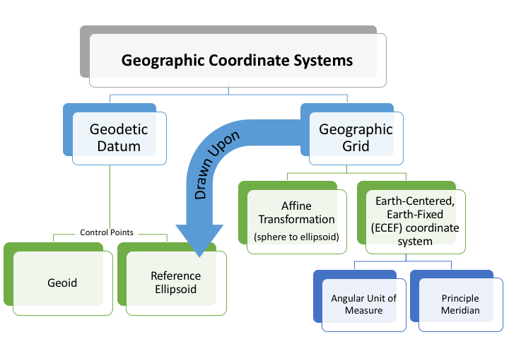 |
| Geographic Coordinate Systems are a complete package: A datum with a specific geographic grid the result of using an established angular unit of measure to label the intersections of north-south and east-west lines on the surface of the Earth starting the labels at a principal meridian the north-south line from which the labeling begins. East-west lines have a very obvious start point: the equator. North-south lines must start somewhere, so when it is established for a particular geographic grid, it can be considered the principal meridian. laid over the reference ellipsoid an ellipsoid that is drawn to best-fit an area. World reference ellipsoids are drawn to best-fit the entire geoid; local ellipsoids are best fit on one side to a single place of the geoid . While it is important to understand how each part is made, this graphic is a simple breakdown of the parts and how they connect. |
| The Main Point... |
|---|
| Creating a Geographic Coordinate System: Select a specific geodetic datum the result of attaching a "free-floating" reference ellipsoid an ellipsoid that is drawn to best-fit an area. World reference ellipsoids are drawn to best-fit the entire geoid; local ellipsoids are best fit on one side to a single place of the geoid to a specifically measured geoid a model of the variation between global mean (average) sea level and local mean sea level the measurement above or below the global average at a single point A GIS vector data in any sort of digital science or art, is simply denoting a type of graphical representation using straight lines to construct the outlines of objects geometry type which is made up of just one vertex pl. vertices One of a set of ordered x,y coordinate pairs that defines the shape of a line or polygon feature. , marking a single XY location in any given geographic or projected coordinate system. on the Earth's surface used for recording the elevation of topographic surface a detailed map of the surface features of land. It includes the mountains, hills, creeks, and other bumps and lumps on a particular hunk of earth. The word is a Greek-rooted combo of topos meaning "place" and graphein "to write." 's relief the difference between the highest and lowest point within a particular area while landforms are the descriptive words for individual features , which is used to measure precise elevations on the topographic surface a detailed map of the surface features of land. It includes the mountains, hills, creeks, and other bumps and lumps on a particular hunk of earth. The word is a Greek-rooted combo of topos meaning "place" and graphein "to write." via control points and benchmarks. (attaching a reference ellipsoid an ellipsoid that is drawn to best-fit an area. World reference ellipsoids are drawn to best-fit the entire geoid; local ellipsoids are best fit on one side to a single place of the geoid to a geoid a model of the variation between global mean (average) sea level and local mean sea level the measurement above or below the global average at a single point A GIS vector data in any sort of digital science or art, is simply denoting a type of graphical representation using straight lines to construct the outlines of objects geometry type which is made up of just one vertex pl. vertices One of a set of ordered x,y coordinate pairs that defines the shape of a line or polygon feature. , marking a single XY location in any given geographic or projected coordinate system. on the Earth's surface used for recording the elevation of topographic surface a detailed map of the surface features of land. It includes the mountains, hills, creeks, and other bumps and lumps on a particular hunk of earth. The word is a Greek-rooted combo of topos meaning "place" and graphein "to write." 's relief the difference between the highest and lowest point within a particular area while landforms are the descriptive words for individual features , which is used to measure precise elevations on the topographic surface a detailed map of the surface features of land. It includes the mountains, hills, creeks, and other bumps and lumps on a particular hunk of earth. The word is a Greek-rooted combo of topos meaning "place" and graphein "to write." via control points) and match it to a geographic grid the result of using an established angular unit of measure to label the intersections of north-south and east-west lines on the surface of the Earth starting the labels at a principal meridian the north-south line from which the labeling begins. East-west lines have a very obvious start point: the equator. North-south lines must start somewhere, so when it is established for a particular geographic grid, it can be considered the principal meridian. (a labeled grid combining an Earth-Centered, Earth-Fixed coordinate system (a principle meridian and an angular unit of measure the selected units for measuring angles. Choices include degree and radians. ) and an affine transformation). The output is an a means to locate and label specific locations on the Earth’s surface. Once these places are labeled, tools such as GPS Global Positioning System: A satellite-based navigation system owned and operated by the United States Department of Defense that provides location and time information anywhere on Earth. units can lead you right to them. The term Geographic Coordinate System is often incorrectly used interchangeably with datum. While they seem similar, a geographic coordinate system is the whole package: a geographic grid the result of using an established angular unit of measure to label the intersections of north-south and east-west lines on the surface of the Earth starting the labels at a principal meridian the north-south line from which the labeling begins. East-west lines have a very obvious start point: the equator. North-south lines must start somewhere, so when it is established for a particular geographic grid, it can be considered the principal meridian. and a datum, while a datum is just the part which links a reference ellipsoid an ellipsoid that is drawn to best-fit an area. World reference ellipsoids are drawn to best-fit the entire geoid; local ellipsoids are best fit on one side to a single place of the geoid to a geoid a model of the variation between global mean (average) sea level and local mean sea level the measurement above or below the global average at a single point A GIS vector data in any sort of digital science or art, is simply denoting a type of graphical representation using straight lines to construct the outlines of objects geometry type which is made up of just one vertex pl. vertices One of a set of ordered x,y coordinate pairs that defines the shape of a line or polygon feature. , marking a single XY location in any given geographic or projected coordinate system. on the Earth's surface used for recording the elevation of topographic surface a detailed map of the surface features of land. It includes the mountains, hills, creeks, and other bumps and lumps on a particular hunk of earth. The word is a Greek-rooted combo of topos meaning "place" and graphein "to write." 's relief the difference between the highest and lowest point within a particular area while landforms are the descriptive words for individual features , which is used to measure precise elevations on the topographic surface a detailed map of the surface features of land. It includes the mountains, hills, creeks, and other bumps and lumps on a particular hunk of earth. The word is a Greek-rooted combo of topos meaning "place" and graphein "to write." . |
Supported Geographic Coordinate Systems
Open in a Separate Page| GCS Name | WKID | Area of Use | Minimum Latitude | Minimum Longitude | Maximum Latitude | Maximum Longitude |
|---|---|---|---|---|---|---|
| 1_Ceres_2015 | 104972 | World | -90 | -180 | 90 | 180 |
| 4_Vesta_2015 | 104973 | World | -90 | -180 | 90 | 180 |
| GCS_Abidjan_1987 | 4143 | Cote d'Ivoire (Ivory Coast) | 1.02 | -8.61 | 10.74 | -2.48 |
| AbInvA96_2020-IRF | 9384 | UK - Aberdeen to Inverness | 57.1 | -4.31 | 57.71 | -2.1 |
| GCS_Accra | 4168 | Ghana | 1.4 | -3.79 | 11.16 | 2.1 |
| GCS_Aden_1925 | 6881 | Yemen - South Yemen - mainland | 12.54 | 43.37 | 19 | 53.14 |
| GCS_Adindan | 4201 | Africa - Eritrea, Ethiopia, South Sudan and Sudan | 3.4 | 21.82 | 22.24 | 47.99 |
| GCS_Adrastea_2000 | 104909 | World | -90 | -180 | 90 | 180 |
| GCS_Afgooye | 4205 | Somalia - onshore | -1.71 | 40.99 | 12.03 | 51.47 |
| GCS_Agadez | 4206 | Niger | 11.69 | 0.16 | 23.53 | 16 |
| GCS_Ain_el_Abd_1970 | 4204 | Asia - Middle East - Bahrain, Kuwait and Saudi Arabia | 16.37 | 34.51 | 32.16 | 55.67 |
| GCS_Airy_1830 | 4001 | Not specified | -90 | -180 | 90 | 180 |
| GCS_Airy_Modified | 4002 | Not specified | -90 | -180 | 90 | 180 |
| GCS_Alaskan_Islands | 37260 | USA - Alaska | 51.3 | 172.42 | 71.4 | -129.99 |
| GCS_Albanian_1987 | 4191 | Albania - onshore | 39.64 | 19.22 | 42.67 | 21.06 |
| GCS_Amalthea_2000 | 104910 | World | -90 | -180 | 90 | 180 |
| GCS_American_Samoa_1962 | 4169 | American Samoa - 2 main island groups | -14.43 | -170.88 | -14.11 | -169.38 |
| AbInvA96_2020-IRF | 9384 | UK - Aberdeen to Inverness | 57.1 | -4.3 | 57.7 | -2.1 |
| GCS_Amersfoort | 4289 | Netherlands - onshore | 50.75 | 3.2 | 53.7 | 7.22 |
| GCS_Ammassalik_1958 | 4196 | Greenland - Ammassalik area | 65.52 | -38.86 | 65.91 | -36.81 |
| GCS_Ananke_2000 | 104911 | World | -90 | -180 | 90 | 180 |
| GCS_Anguilla_1957 | 4600 | Anguilla - onshore | 18.11 | -63.22 | 18.33 | -62.92 |
| GCS_Anna_1_1965 | 4708 | Cocos (Keeling) Islands - onshore | -12.27 | 96.76 | -11.76 | 96.99 |
| GCS_Antigua_1943 | 4601 | Antigua - onshore | 16.94 | -61.95 | 17.22 | -61.61 |
| GCS_Aratu | 4208 | Brazil - Aratu | -35.71 | -53.38 | 4.26 | -26 |
| GCS_Arc_1950 | 4209 | Africa - Botswana, Malawi, Zambia, Zimbabwe | -26.88 | 19.99 | -8.19 | 35.93 |
| GCS_Arc_1960 | 4210 | Africa - Burundi, Kenya, Rwanda, Tanzania and Uganda | -11.75 | 28.85 | 4.63 | 41.91 |
| GCS_Ariel_2000 | 104945 | World | -90 | -180 | 90 | 180 |
| GCS_Ascension_Island_1958 | 4712 | St Helena - Ascension Island | -8.03 | -14.46 | -7.83 | -14.24 |
| GCS_Astro_1952 | 4711 | Japan - Minamitori-shima (Marcus Island) - onshore | 24.22 | 153.91 | 24.35 | 154.05 |
| GCS_ATF_Paris | 4901 | France - mainland onshore | 42.33 | -4.87 | 51.14 | 8.23 |
| GCS_Atlas_2000 | 104926 | World | -90 | -180 | 90 | 180 |
| ATRF2014 | 9309 | Australia - GDA | -60.55 | 93.41 | -8.47 | 173.34 |
| GCS_ATS_1977 | 4122 | Canada - Maritime Provinces | 43.41 | -69.05 | 48.07 | -59.73 |
| GCS_Australian | 4003 | Not specified | -90 | -180 | 90 | 180 |
| GCS_Australian_1966 | 4202 | Australasia - Australia and PNG - AGD66 | -47.2 | 109.23 | -1.3 | 163.2 |
| GCS_Australian_1984 | 4203 | Australia - AGD84 | -38.53 | 109.23 | -9.37 | 153.61 |
| GCS_Australian_Antarctic_1998 | 4176 | Antarctica - Australian sector | -90 | 45 | -60 | 160 |
| GCS_Ayabelle | 4713 | Djibouti | 10.94 | 41.75 | 12.72 | 44.15 |
| GCS_Azores_Central_1948 | 4183 | Portugal - Azores C - onshore | 38.32 | -28.9 | 39.14 | -26.97 |
| GCS_Azores_Central_1995 | 4665 | Portugal - Azores C - onshore | 38.32 | -28.9 | 39.14 | -26.97 |
| GCS_Azores_Occidental_1939 | 4182 | Portugal - Azores W - onshore | 39.3 | -31.34 | 39.77 | -31.02 |
| GCS_Azores_Oriental_1940 | 4184 | Portugal - Azores E - onshore | 36.87 | -25.92 | 37.96 | -24.62 |
| GCS_Azores_Oriental_1995 | 4664 | Portugal - Azores E - onshore | 36.87 | -25.92 | 37.96 | -24.62 |
| GCS_Bab_South | 104112 | Palau | 1.64 | 129.48 | 11.45 | 136.98 |
| GCS_Barbados_1938 | 4212 | Barbados - onshore | 13 | -59.71 | 13.39 | -59.37 |
| GCS_Batavia | 4211 | Indonesia - Java, Java Sea and western Sumatra | -8.91 | 95.16 | 5.97 | 117.01 |
| GCS_Batavia_Jakarta | 4813 | Indonesia - Bali, Java and western Sumatra onshore | -8.91 | 95.16 | 5.97 | 115.77 |
| GCS_Beacon_E_1945 | 4709 | Japan - Iwo Jima | 24.67 | 141.2 | 24.89 | 141.42 |
| GCS_Beduaram | 4213 | Niger - southeast | 12.8 | 7.81 | 16.7 | 14.9 |
| GCS_Beijing_1954 | 4214 | China | 16.7 | 73.62 | 53.56 | 134.77 |
| GCS_Bekaa_Valley_1920 | 6882 | Lebanon - onshore | 33.06 | 35.04 | 34.65 | 36.63 |
| GCS_Belge_1950 | 4215 | Belgium - onshore | 49.5 | 2.5 | 51.51 | 6.4 |
| GCS_Belge_1950_Brussels | 4809 | Belgium - onshore | 49.5 | 2.5 | 51.51 | 6.4 |
| GCS_Belge_1972 | 4313 | Belgium - onshore | 49.5 | 2.5 | 51.51 | 6.4 |
| GCS_Belinda_2000 | 104946 | World | -90 | -180 | 90 | 180 |
| GCS_Bellevue_IGN | 4714 | Vanuatu - southern islands | -20.31 | 168.09 | -17.37 | 169.95 |
| GCS_Bermuda_1957 | 4216 | Bermuda - onshore | 32.21 | -64.89 | 32.43 | -64.61 |
| GCS_Bermuda_2000 | 4762 | Bermuda | 28.91 | -68.83 | 35.73 | -60.7 |
| GCS_Bern_1898_Bern | 4801 | Europe - Liechtenstein and Switzerland | 45.82 | 5.96 | 47.81 | 10.49 |
| GCS_Bern_1938 | 4306 | Europe - Liechtenstein and Switzerland | 45.82 | 5.96 | 47.81 | 10.49 |
| GCS_Bessel_1841 | 4004 | Not specified | -90 | -180 | 90 | 180 |
| GCS_Bessel_Modified | 4005 | Not specified | -90 | -180 | 90 | 180 |
| GCS_Bessel_Namibia | 4006 | Not specified | -90 | -180 | 90 | 180 |
| BGS2005 | 7798 | Bulgaria | 41.24 | 22.36 | 44.23 | 31.35 |
| GCS_Bianca_2000 | 104947 | World | -90 | -180 | 90 | 180 |
| GCS_Bioko | 6883 | Equatorial Guinea - Bioko | 3.14 | 8.37 | 3.82 | 9.02 |
| GCS_Bissau | 4165 | Guinea-Bissau - onshore | 10.87 | -16.77 | 12.69 | -13.64 |
| GCS_Bogota | 4218 | Colombia - mainland and offshore Caribbean | -4.23 | -79.1 | 13.68 | -66.87 |
| GCS_Bogota_Bogota | 4802 | Colombia - mainland | -4.23 | -79.1 | 12.52 | -66.87 |
| GCS_Bukit_Rimpah | 4219 | Indonesia - Banga & Belitung Islands | -3.3 | 105.07 | -1.44 | 108.35 |
| GCS_Cadastre_1997 | 4475 | Mayotte - onshore | -13.05 | 44.98 | -12.61 | 45.35 |
| California_SRS_Epoch_2017.50_(NAD 83) | 104024 | USA - California and borders of NV, AZ, OR and MX | 32.25 | -124.44 | 42.53 | -113.6 |
| GCS_Callisto_2000 | 104912 | World | -90 | -180 | 90 | 180 |
| GCS_Calypso_2000 | 104927 | World | -90 | -180 | 90 | 180 |
| GCS_Camacupa | 4220 | Angola - Angola proper | -18.02 | 8.2 | -5.82 | 24.09 |
| Camacupa_2015 | 8694 | Angola | -18.02 | 8.2 | -4.38 | 24.09 |
| GCS_Camp_Area | 4715 | Antarctica - Camp McMurdo area | -77.94 | 165.73 | -77.17 | 167.43 |
| GCS_Campo_Inchauspe | 4221 | Argentina - mainland onshore and offshore Tierra del Fuego | -54.93 | -73.59 | -21.78 | -53.65 |
| GCS_Canton_1966 | 4716 | Kiribati - Phoenix Islands | -4.76 | -174.6 | -2.68 | -170.66 |
| GCS_Cape | 4222 | Africa - Botswana, Eswatini, Lesotho and South Africa | -34.88 | 16.45 | -17.78 | 32.95 |
| GCS_Cape_Canaveral | 4717 | North America - Bahamas and USA - Florida - onshore | 20.86 | -82.33 | 30.83 | -72.68 |
| GCS_Carme_2000 | 104913 | World | -90 | -180 | 90 | 180 |
| GCS_Carthage | 4223 | Tunisia | 30.23 | 7.49 | 38.41 | 13.67 |
| GCS_Carthage_Grad | 37225 | Tunisia | 30.23 | 7.49 | 38.41 | 13.67 |
| GCS_Carthage_Paris | 4816 | Tunisia - onshore | 30.23 | 7.49 | 37.4 | 11.59 |
| GCS_CGRS_1993 | 6311 | Cyprus - onshore | 34.59 | 32.2 | 35.74 | 34.65 |
| GCS_CH1903 | 4149 | Europe - Liechtenstein and Switzerland | 45.82 | 5.96 | 47.81 | 10.49 |
| GCS_CH1903+ | 4150 | Europe - Liechtenstein and Switzerland | 45.82 | 5.96 | 47.81 | 10.49 |
| GCS_Charon_2000 | 104970 | World | -90 | -180 | 90 | 180 |
| GCS_Chatham_Island_1971 | 4672 | New Zealand - Chatham Islands group | -44.64 | -177.25 | -43.3 | -175.54 |
| GCS_Chatham_Islands_1979 | 4673 | New Zealand - Chatham Islands group | -44.64 | -177.25 | -43.3 | -175.54 |
| GCS_China_Geodetic_Coordinate_ System_2000 | 4490 | China | 16.7 | 73.62 | 53.56 | 134.77 |
| GCS_Chos_Malal_1914 | 4160 | Argentina - Neuquen province | -41.1 | -71.96 | -36.14 | -68.01 |
| GCS_Chua | 4224 | South America - Brazil - south of 18° S and west of 54° W + Distrito Federal; N Paraguay | -31.91 | -62.57 | -15.37 | -47.1 |
| GCS_CIGD11 | 6135 | Cayman Islands | 17.58 | -83.6 | 20.68 | -78.72 |
| GCS_Clarke_1858 | 4007 | Not specified | -90 | -180 | 90 | 180 |
| GCS_Clarke_1866 | 4008 | Not specified | -90 | -180 | 90 | 180 |
| GCS_Clarke_1866_Michigan | 4009 | Not specified | -90 | -180 | 90 | 180 |
| GCS_Clarke_1880 | 4034 | Not specified | -90 | -180 | 90 | 180 |
| GCS_Clarke_1880_Arc | 4013 | Not specified | -90 | -180 | 90 | 180 |
| GCS_Clarke_1880_Benoit | 4010 | Not specified | -90 | -180 | 90 | 180 |
| GCS_Clarke_1880_IGN | 4011 | Not specified | -90 | -180 | 90 | 180 |
| GCS_Clarke_1880_RGS | 4012 | Not specified | -90 | -180 | 90 | 180 |
| GCS_Clarke_1880_SGA | 4014 | Not specified | -90 | -180 | 90 | 180 |
| GCS_Combani_1950 | 4632 | Mayotte - onshore | -13.05 | 44.98 | -12.61 | 45.35 |
| GCS_Conakry_1905 | 4315 | Guinea - onshore | 7.19 | -15.13 | 12.68 | -7.65 |
| GCS_Cordelia_2000 | 104948 | World | -90 | -180 | 90 | 180 |
| GCS_Corrego_Alegre | 4225 | Brazil - Corrego Alegre 1970- 1972 | -33.78 | -58.16 | -2.68 | -34.74 |
| GCS_Corrego_Alegre_1961 | 5524 | Brazil - Corrego Alegre 1961 | -27.5 | -58.16 | -14.99 | -38.82 |
| GCS_Cote_d_Ivoire | 4226 | Cote d'Ivoire (Ivory Coast) | 1.02 | -8.61 | 10.74 | -2.48 |
| GCS_CR05 | 5365 | Costa Rica | 2.15 | -90.45 | 11.77 | -81.43 |
| CR-SIRGAS | 8907 | Costa Rica | 2.15 | -90.45 | 11.77 | -81.43 |
| GCS_Cressida_2000 | 104949 | World | -90 | -180 | 90 | 180 |
| GCS_CSG_1967 | 4623 | French Guiana - coastal area | 3.43 | -54.45 | 5.81 | -51.61 |
| GCS_D48 | 104131 | Slovenia | 45.42 | 13.38 | 46.88 | 16.61 |
| GCS_Dabola_1981 | 4155 | Guinea - onshore | 7.19 | -15.13 | 12.68 | -7.65 |
| GCS_Datum_73 | 4274 | Portugal - mainland - onshore | 36.95 | -9.56 | 42.16 | -6.19 |
| GCS_Datum_Lisboa_Bessel | 104105 | Portugal | 29.24 | -35.58 | 43.07 | -6.19 |
| GCS_Datum_Lisboa_Hayford | 104106 | Portugal | 29.24 | -35.58 | 43.07 | -6.19 |
| GCS_DB_REF | 5681 | Germany - onshore | 47.27 | 5.86 | 55.09 | 15.04 |
| GCS_Dealul_Piscului_1933 | 4316 | Romania - onshore | 43.62 | 20.26 | 48.27 | 29.74 |
| GCS_Dealul_Piscului_1970 | 4317 | Romania | 43.44 | 20.26 | 48.27 | 31.41 |
| GCS_Deception_Island | 4736 | Antarctica - Deception Island | -63.08 | -60.89 | -62.82 | -60.35 |
| GCS_Deimos_2000 | 104906 | World | -90 | -180 | 90 | 180 |
| GCS_Deir_ez_Zor | 4227 | Asia - Middle East - Lebanon and Syria onshore | 32.31 | 35.04 | 37.3 | 42.38 |
| GCS_Desdemona_2000 | 104950 | World | -90 | -180 | 90 | 180 |
| GCS_Despina_2000 | 104961 | World | -90 | -180 | 90 | 180 |
| GCS_Deutsches_Hauptdreiecksnetz | 4314 | Germany | 47.27 | 3.34 | 55.92 | 15.04 |
| GCS_DGN_1995 | 4755 | Indonesia | -13.95 | 92.01 | 7.79 | 141.46 |
| GCS_Dione_2000 | 104928 | World | -90 | -180 | 90 | 180 |
| GCS_Dominica_1945 | 4602 | Dominica - onshore | 15.14 | -61.55 | 15.69 | -61.2 |
| GCS_DOS_1968 | 37218 | Solomon Islands - New Georgia - Ghizo (Gizo) | -8.86 | 156.44 | -7.52 | 158.2 |
| GCS_DOS_71_4 | 4710 | St Helena - St Helena Island | -16.08 | -5.85 | -15.85 | -5.58 |
| GCS_Douala | 4228 | Cameroon | 1.65 | 8.32 | 13.09 | 16.21 |
| GCS_Douala_1948 | 4192 | Cameroon - coastal area | 2.16 | 8.45 | 4.99 | 10.4 |
| GCS_DRUKREF_03 | 5264 | Bhutan | 26.7 | 88.74 | 28.33 | 92.13 |
| GCS_Easter_Island_1967 | 4719 | Chile - Easter Island onshore | -27.25 | -109.51 | -27.01 | -109.16 |
| ECML14_NB-IRF | 9758 | UK - Newcastle to Ashington | 54.85 | -1.9 | 55.3 | -1.3 |
| GCS_Egypt_1907 | 4229 | Egypt | 21.89 | 24.7 | 33.82 | 37.91 |
| GCS_Egypt_1930 | 4199 | Egypt - onshore | 21.97 | 24.7 | 31.68 | 36.95 |
| GCS_Egypt_Gulf_of_Suez_S-650_TL | 4706 | Egypt - Gulf of Suez | 27.19 | 32.34 | 30.01 | 34.27 |
| GCS_Elara_2000 | 104914 | World | -90 | -180 | 90 | 180 |
| GCS_Enceladus_2000 | 104929 | World | -90 | -180 | 90 | 180 |
| EOS21-IRF | 9739 | UK - Tweedmouth to Aberdeen | 55.55 | -3.55 | 57.2 | -1.95 |
| GCS_Epimetheus_2000 | 104930 | World | -90 | -180 | 90 | 180 |
| GCS_Estonia_1937 | 104101 | Estonia | 57.52 | 20.37 | 60 | 28.2 |
| GCS_Estonia_1992 | 4133 | Estonia - onshore | 57.52 | 21.74 | 59.75 | 28.2 |
| GCS_Estonia_1997 | 4180 | Estonia | 57.52 | 20.37 | 60 | 28.2 |
| ETRF2000 | 9067 | Europe - ETRF by country | 32.88 | -16.1 | 84.73 | 40.18 |
| ETRF2000-PL | 9702 | Poland | 49 | 14.14 | 55.93 | 24.15 |
| ETRF2005 | 9068 | Europe - ETRF by country | 32.88 | -16.1 | 84.73 | 40.18 |
| ETRF2014 | 9069 | Europe - ETRF by country | 32.88 | -16.1 | 84.73 | 40.18 |
| GCS_ETRF_1989 | 9059 | Europe - ETRF by country | 32.88 | -16.1 | 84.73 | 40.18 |
| ETRF90 | 9060 | Europe - ETRF by country | 32.88 | -16.1 | 84.73 | 40.18 |
| ETRF91 | 9061 | Europe - ETRF by country | 32.88 | -16.1 | 84.73 | 40.18 |
| ETRF92 | 9062 | Europe - ETRF by country | 32.88 | -16.1 | 84.73 | 40.18 |
| ETRF93 | 9063 | Europe - ETRF by country | 32.88 | -16.1 | 84.73 | 40.18 |
| ETRF94 | 9064 | Europe - ETRF by country | 32.88 | -16.1 | 84.73 | 40.18 |
| ETRF96 | 9065 | Europe - ETRF by country | 32.88 | -16.1 | 84.73 | 40.18 |
| ETRF97 | 9066 | Europe - ETRF by country | 32.88 | -16.1 | 84.73 | 40.18 |
| GCS_ETRS_1989 | 4258 | Europe - ETRF by country | 32.88 | -16.1 | 84.73 | 40.18 |
| GCS_EUREF_FIN | 104129 | Finland | 58.84 | 19.08 | 70.09 | 31.59 |
| GCS_Europa_2000 | 104915 | World | -90 | -180 | 90 | 180 |
| GCS_European_1950 | 4230 | Europe - ED50 by country | 25.71 | -16.1 | 84.73 | 48.61 |
| GCS_European_1950_ED77 | 4154 | Iran | 23.34 | 44.03 | 39.78 | 63.34 |
| GCS_European_1979 | 4668 | Europe - west | 34.88 | -10.56 | 84.73 | 39.65 |
| GCS_European_1987 | 4231 | Europe - west | 34.88 | -10.56 | 84.73 | 39.65 |
| GCS_European_Libyan_Datum_1979 | 4159 | Libya | 19.49 | 9.31 | 35.23 | 26.21 |
| GCS_Everest_1830 | 4042 | Not specified | -90 | -180 | 90 | 180 |
| GCS_Everest_Adj_1937 | 4015 | Not specified | -90 | -180 | 90 | 180 |
| GCS_Everest_Bangladesh | 37202 | Bangladesh | 18.56 | 88.01 | 26.64 | 92.67 |
| GCS_Everest_def_1962 | 4044 | Not specified | -90 | -180 | 90 | 180 |
| GCS_Everest_def_1967 | 4016 | Not specified | -90 | -180 | 90 | 180 |
| GCS_Everest_def_1975 | 4045 | Not specified | -90 | -180 | 90 | 180 |
| GCS_Everest_India_Nepal | 37203 | India | 3.87 | 65.6 | 35.51 | 97.42 |
| GCS_Everest_Modified | 4018 | Not specified | -90 | -180 | 90 | 180 |
| GCS_Everest_Modified_1969 | 37006 | World | -90 | -180 | 90 | 180 |
| GCS_Fahud | 4232 | Oman - mainland | 16.59 | 51.99 | 26.42 | 59.91 |
| GCS_Fatu_Iva_1972 | 4688 | French Polynesia - Marquesas Islands - Fatu Hiva | -10.6 | -138.75 | -10.36 | -138.54 |
| GCS_FD_1954 | 4741 | Faroe Islands - onshore | 61.33 | -7.49 | 62.41 | -6.33 |
| GCS_FD_1958 | 4132 | Iran - FD58 | 26.21 | 47.13 | 33.22 | 53.61 |
| GCS_FEH2010 | 5593 | Europe - Fehmarnbelt outer | 54.33 | 10.66 | 54.83 | 12.01 |
| GCS_Fiji_1956 | 4721 | Fiji - main islands | -19.22 | 176.81 | -16.1 | -179.77 |
| GCS_Fiji_1986 | 4720 | Fiji - onshore | -20.81 | 176.81 | -12.42 | -178.15 |
| GCS_Fischer_1960 | 37002 | World | -90 | -180 | 90 | 180 |
| GCS_Fischer_1968 | 37003 | World | -90 | -180 | 90 | 180 |
| GCS_Fischer_Modified | 37004 | World | -90 | -180 | 90 | 180 |
| GCS_fk89 | 4753 | Faroe Islands - onshore | 61.33 | -7.49 | 62.41 | -6.33 |
| GCS_Fort_Desaix | 4625 | Martinique - onshore | 14.35 | -61.29 | 14.93 | -60.76 |
| GCS_Fort_Marigot | 4621 | Guadeloupe - St Martin and St Barthelemy - onshore | 17.82 | -63.21 | 18.17 | -62.73 |
| GCS_Fort_Thomas_1955 | 37240 | St Kitts and Nevis | 16.34 | -63.63 | 17.67 | -62.2 |
| GCS_Galatea_2000 | 104962 | World | -90 | -180 | 90 | 180 |
| GCS_Gambia | 6894 | Gambia - onshore | 13.05 | -16.88 | 13.83 | -13.79 |
| GCS_Gan_1970 | 4684 | Maldives - onshore | -0.69 | 72.81 | 7.08 | 73.69 |
| GCS_Ganymede_2000 | 104916 | World | -90 | -180 | 90 | 180 |
| GCS_Garoua | 4197 | Cameroon - Garoua area | 8.92 | 12.9 | 9.87 | 14.19 |
| GBK19-IRF | 9453 | UK - Glasgow to Kilmarnock | 55.55 | -4.65 | 55.95 | -4.05 |
| GCS_GDA_1994 | 4283 | Australia - GDA | -60.55 | 93.41 | -8.47 | 173.34 |
| GDA2020 | 7844 | Australia - GDA | -60.55 | 93.41 | -8.47 | 173.34 |
| GCS_GDBD2009 | 5246 | Brunei | 4.01 | 112.37 | 6.31 | 115.37 |
| GCS_GDM_2000 | 4742 | Malaysia | 0.85 | 98.02 | 7.81 | 119.61 |
| GDM2008 | 104028 | Mauritius | -23.81 | 53.8 | -8.43 | 67.05 |
| GCS_GEM_10C | 4031 | Not specified | -90 | -180 | 90 | 180 |
| GGD | 104022 | Georgia - onshore | 41.04 | 39.99 | 43.59 | 46.72 |
| GCS_GGRS_1987 | 4121 | Greece - onshore | 34.88 | 19.57 | 41.75 | 28.3 |
| GCS_Graciosa_Base_SW_1948 | 37241 | Portugal - Azores C - onshore | 38.32 | -28.9 | 39.14 | -26.97 |
| GCS_Grand_Cayman_1959 | 4723 | Cayman Islands - Grand Cayman | 19.21 | -81.46 | 19.41 | -81.04 |
| GCS_Grand_Comoros | 4646 | Comoros - Njazidja (Grande Comore) | -11.99 | 43.16 | -11.31 | 43.55 |
| GCS_Greek | 4120 | Greece - onshore | 34.88 | 19.57 | 41.75 | 28.3 |
| GCS_Greek_Athens | 4815 | Greece - onshore | 34.88 | 19.57 | 41.75 | 28.3 |
| GCS_Greenland_1996 | 4747 | Greenland | 56.38 | -75 | 87.03 | 7.99 |
| GCS_Grenada_1953 | 4603 | Grenada and southern Grenadines - onshore | 11.94 | -61.84 | 12.57 | -61.35 |
| GCS_GRS_1967 | 4036 | Not specified | -90 | -180 | 90 | 180 |
| GCS_GRS_1980 | 4019 | Not specified | -90 | -180 | 90 | 180 |
| GSK-2011 | 7683 | Russia | 39.87 | 18.92 | 85.2 | -168.97 |
| GCS_Guam_1963 | 4675 | Pacific - US interests Mariana plate | 1.64 | 129.48 | 23.9 | 149.55 |
| GCS_Gulshan_303 | 4682 | Bangladesh | 18.56 | 88.01 | 26.64 | 92.67 |
| GCS_Gunung_Segara | 4613 | Indonesia - Kalimantan E | -4.24 | 114.55 | 4.29 | 119.06 |
| GCS_Gunung_Segara_Jakarta | 4820 | Indonesia - Kalimantan E | -4.24 | 114.55 | 4.29 | 119.06 |
| Gusterberg(Ferro) | 8042 | Europe - Upper Austria, Salzburg and Bohemia | 46.93 | 12.07 | 51.06 | 16.83 |
| GCS_GUX_1 | 37221 | Solomon Islands - Guadalcanal Island | -9.98 | 159.55 | -9.2 | 160.88 |
| GCS_Guyane_Francaise | 4235 | French Guiana | 2.11 | -54.61 | 8.88 | -49.45 |
| GCS_Hanoi_1972 | 4147 | Vietnam - onshore | 8.33 | 102.14 | 23.4 | 109.53 |
| GCS_Hartebeesthoek_1994 | 4148 | South Africa | -50.32 | 13.33 | -22.13 | 42.85 |
| GCS_HD1909 | 3819 | Hungary | 45.74 | 16.11 | 48.58 | 22.9 |
| GCS_Helene_2000 | 104931 | World | -90 | -180 | 90 | 180 |
| GCS_Helle_1954 | 4660 | Jan Mayen - onshore | 70.75 | -9.17 | 71.24 | -7.87 |
| GCS_Helmert_1906 | 4020 | Not specified | -90 | -180 | 90 | 180 |
| GCS_Herat_North | 4255 | Afghanistan | 29.4 | 60.5 | 38.48 | 74.92 |
| GCS_Hermannskogel | 104102 | Europe - Austria and former Yugoslavia onshore | 40.85 | 9.53 | 49.02 | 23.04 |
| GCS_Himalia_2000 | 104917 | World | -90 | -180 | 90 | 180 |
| GCS_Hito_XVIII_1963 | 4254 | South America - Tierra del Fuego | -55.96 | -74.83 | -51.65 | -63.73 |
| GCS_Hjorsey_1955 | 4658 | Iceland - onshore | 63.34 | -24.66 | 66.59 | -13.38 |
| GCS_Hong_Kong_1963 | 4738 | China - Hong Kong | 22.13 | 113.76 | 22.58 | 114.51 |
| GCS_Hong_Kong_1963_67 | 4739 | China - Hong Kong | 22.13 | 113.76 | 22.58 | 114.51 |
| GCS_Hong_Kong_1980 | 4611 | China - Hong Kong | 22.13 | 113.76 | 22.58 | 114.51 |
| Hong_Kong_Geodetic_CS | 8427 | China - Hong Kong | 22.13 | 113.76 | 22.58 | 114.51 |
| GCS_Hough_1960 | 37005 | World | -90 | -180 | 90 | 180 |
| HS2-IRF | 9299 | UK - London to Birmingham and Crewe | 51.45 | -2.75 | 53.3 | 0 |
| GCS_HTRS96 | 4761 | Croatia | 41.62 | 13 | 46.54 | 19.43 |
| GCS_Hughes_1980 | 4054 | Not specified | -90 | -180 | 90 | 180 |
| GCS_Hungarian_1972 | 4237 | Hungary | 45.74 | 16.11 | 48.58 | 22.9 |
| GCS_Hu_Tzu_Shan | 4236 | Taiwan - onshore - mainland and Penghu | 21.87 | 119.25 | 25.34 | 122.06 |
| GCS_Hyperion_2000 | 104932 | World | -90 | -180 | 90 | 180 |
| GCS_Iapetus_2000 | 104933 | World | -90 | -180 | 90 | 180 |
| IG05(2012)_Intermediate_CRS | 6990 | Asia - Middle East - Israel and Palestine Territory onshore | 29.45 | 34.17 | 33.28 | 35.69 |
| IG05_Intermediate_CRS | 6983 | Asia - Middle East - Israel and Palestine Territory onshore | 29.45 | 34.17 | 33.28 | 35.69 |
| IGb00 | 9009 | World | -90 | -180 | 90 | 180 |
| IGb08 | 9017 | World | -90 | -180 | 90 | 180 |
| IGb14 | 9380 | World | -90 | -180 | 90 | 180 |
| GCS_IGC_1962_6th_Parallel_South | 4697 | Congo DR (Zaire) - 6th parallel south | -7.36 | 12.17 | -3.29 | 29.64 |
| GCS_IGCB_1955 | 4701 | Congo DR (Zaire) - Bas Congo | -6.04 | 12.17 | -4.28 | 16.28 |
| IGD05 | 7136 | Israel | 29.45 | 32.99 | 33.53 | 35.69 |
| IGD05(2012) | 7139 | Israel | 29.45 | 32.99 | 33.53 | 35.69 |
| GCS_IGM_1995 | 4670 | Italy - including San Marino and Vatican | 34.76 | 5.93 | 47.1 | 18.99 |
| GCS_IGN53_Mare | 4641 | New Caledonia - Mare | -21.71 | 167.75 | -21.32 | 168.19 |
| GCS_IGN56_Lifou | 4633 | New Caledonia - Lifou | -21.24 | 166.98 | -20.62 | 167.52 |
| GCS_IGN63_Hiva_Oa | 4689 | French Polynesia - Marquesas Islands - Hiva Oa and Tahuata | -10.08 | -139.23 | -9.64 | -138.75 |
| GCS_IGN72_Grande_Terre | 4662 | New Caledonia - Grande Terre | -22.45 | 163.92 | -20.03 | 167.09 |
| GCS_IGN72_Nuku_Hiva | 4630 | French Polynesia - Marquesas Islands - Nuku Hiva, Ua Huka and Ua Pou | -9.57 | -140.31 | -8.72 | -139.44 |
| GCS_IGN_Astro_1960 | 4700 | Mauritania - onshore | 14.72 | -17.08 | 27.3 | -4.8 |
| GCS_IGRS | 3889 | Iraq | 29.06 | 38.79 | 37.39 | 48.75 |
| IGS00 | 9006 | World | -90 | -180 | 90 | 180 |
| IGS05 | 9012 | World | -90 | -180 | 90 | 180 |
| GCS_IGS08 | 9014 | World (by country) | -90 | -180 | 90 | 180 |
| IGS14 | 9019 | World | -90 | -180 | 90 | 180 |
| IGS97 | 9003 | World | -90 | -180 | 90 | 180 |
| GCS_IKBD_1992 | 4667 | Asia - Middle East - Iraq- Kuwait boundary | 29.06 | 46.36 | 30.32 | 48.61 |
| GCS_Indian_1954 | 4239 | Asia - Myanmar and Thailand onshore | 5.63 | 92.2 | 28.55 | 105.64 |
| GCS_Indian_1960 | 4131 | Asia - Cambodia and Vietnam - onshore & Cuu Long basin | 7.99 | 102.14 | 23.4 | 110 |
| GCS_Indian_1975 | 4240 | Thailand - onshore and Gulf of Thailand | 5.63 | 97.34 | 20.46 | 105.64 |
| GCS_Indonesian | 4021 | Not specified | -90 | -180 | 90 | 180 |
| GCS_Indonesian_1974 | 4238 | Indonesia - onshore | -10.98 | 95.16 | 5.97 | 141.01 |
| GCS_International_1924 | 4022 | Not specified | -90 | -180 | 90 | 180 |
| GCS_Io_2000 | 104918 | World | -90 | -180 | 90 | 180 |
| GCS_IRENET95 | 4173 | Europe - Ireland (Republic and Ulster) - onshore | 51.39 | -10.56 | 55.43 | -5.34 |
| GCS_ISN_1993 | 4659 | Iceland | 59.96 | -30.87 | 69.59 | -5.55 |
| GCS_ISN_2004 | 5324 | Iceland | 59.96 | -30.87 | 69.59 | -5.55 |
| ISN2016 | 8086 | Iceland | 59.96 | -30.87 | 69.59 | -5.55 |
| GCS_Israel | 4141 | Israel, Palestine Territory, and Jordan | 29.19 | 32.99 | 33.53 | 39.3 |
| GCS_ISTS_061_1968 | 4722 | South Georgia - onshore | -54.95 | -38.08 | -53.93 | -35.74 |
| GCS_ISTS_073_1969 | 4724 | British Indian Ocean Territory - Diego Garcia | -7.49 | 72.3 | -7.18 | 72.55 |
| GCS_ITRF_1988 | 8988 | World | -90 | -180 | 90 | 180 |
| GCS_ITRF_1989 | 8989 | World | -90 | -180 | 90 | 180 |
| GCS_ITRF_1990 | 8990 | World | -90 | -180 | 90 | 180 |
| GCS_ITRF_1991 | 8991 | World | -90 | -180 | 90 | 180 |
| GCS_ITRF_1992 | 8992 | World | -90 | -180 | 90 | 180 |
| GCS_ITRF_1993 | 8993 | World | -90 | -180 | 90 | 180 |
| GCS_ITRF_1994 | 8994 | World | -90 | -180 | 90 | 180 |
| GCS_ITRF_1996 | 8995 | World | -90 | -180 | 90 | 180 |
| GCS_ITRF_1997 | 8996 | World | -90 | -180 | 90 | 180 |
| GCS_ITRF_2000 | 8997 | World | -90 | -180 | 90 | 180 |
| GCS_ITRF_2005 | 8998 | World | -90 | -180 | 90 | 180 |
| GCS_ITRF_2008 | 8999 | World (by country) | -90 | -180 | 90 | 180 |
| ITRF2014 | 9000 | World | -90 | -180 | 90 | 180 |
| GCS_JAD_2001 | 4758 | Jamaica | 14.08 | -80.6 | 19.36 | -74.51 |
| GCS_Jamaica_1875 | 4241 | Jamaica - onshore | 17.64 | -78.43 | 18.58 | -76.17 |
| GCS_Jamaica_1969 | 4242 | Jamaica - onshore | 17.64 | -78.43 | 18.58 | -76.17 |
| GCS_Janus_2000 | 104934 | World | -90 | -180 | 90 | 180 |
| GCS_JGD_2000 | 4612 | Japan | 17.09 | 122.38 | 46.05 | 157.65 |
| GCS_JGD_2011 | 6668 | Japan | 17.09 | 122.38 | 46.05 | 157.65 |
| GCS_Johnston_Island_1961 | 4725 | Johnston Island | 16.67 | -169.59 | 16.79 | -169.47 |
| GCS_Jordan | 104130 | Jordan | 29.18 | 34.88 | 33.38 | 39.31 |
| GCS_Jouik_1961 | 4679 | Mauritania - north coast | 19.37 | -17.08 | 21.34 | -15.88 |
| GCS_Juliet_2000 | 104951 | World | -90 | -180 | 90 | 180 |
| GCS_Jupiter_2000 | 104908 | World | -90 | -180 | 90 | 180 |
| GCS_Kalianpur_1880 | 4243 | Asia - Bangladesh; India; Myanmar; Pakistan - onshore | 8.02 | 60.86 | 37.07 | 101.17 |
| GCS_Kalianpur_1937 | 4144 | Asia - Bangladesh; India; Myanmar; Pakistan - onshore; Moattama offshore | 8.02 | 60.86 | 37.07 | 101.17 |
| GCS_Kalianpur_1962 | 4145 | Pakistan | 21.05 | 60.86 | 37.07 | 77.83 |
| GCS_Kalianpur_1975 | 4146 | India - mainland | 8.02 | 68.13 | 35.51 | 97.42 |
| GCS_Kandawala | 4244 | Sri Lanka - onshore | 5.86 | 79.64 | 9.88 | 81.95 |
| GCS_Karbala_1979_Polservice | 4743 | Iraq - onshore | 29.06 | 38.79 | 37.39 | 48.61 |
| GCS_Kasai_1953 | 4696 | Congo DR (Zaire) - Kasai - SE | -7.31 | 21.5 | -5.01 | 26.26 |
| GCS_Katanga_1955 | 4695 | Congo DR (Zaire) - Katanga | -13.46 | 21.74 | -4.99 | 30.78 |
| GCS_Kerguelen_Island_1949 | 4698 | French Southern Territories - Kerguelen onshore | -49.78 | 68.69 | -48.6 | 70.62 |
| GCS_Kertau | 4245 | Asia - Malaysia (west including SCS) and Singapore | 1.13 | 99.59 | 7.81 | 105.82 |
| GCS_Kertau_RSO | 4751 | Asia - Malaysia (west) and Singapore | 1.13 | 99.59 | 6.72 | 104.6 |
| GCS_KKJ | 4123 | Finland - onshore | 59.75 | 19.24 | 70.09 | 31.59 |
| GCS_Korea_2000 | 4737 | Korea, Republic of (South Korea) | 28.6 | 122.71 | 40.27 | 134.28 |
| GCS_Korean_Datum_1985 | 4162 | Korea, Republic of (South Korea) - onshore | 33.14 | 124.53 | 38.64 | 131.01 |
| GCS_Korean_Datum_1995 | 4166 | Korea, Republic of (South Korea) - onshore | 33.14 | 124.53 | 38.64 | 131.01 |
| KOSOVAREF01 | 9140 | Kosovo | 41.85 | 19.97 | 43.25 | 21.8 |
| GCS_Kousseri | 4198 | Cameroon - N'Djamena area | 11.7 | 14.17 | 12.77 | 15.09 |
| GCS_Krasovsky_1940 | 4024 | Not specified | -90 | -180 | 90 | 180 |
| KSA-GRF17 | 9333 | Saudi Arabia | 16.29 | 34.44 | 32.16 | 55.67 |
| GCS_KUDAMS | 4319 | Kuwait | 28.53 | 46.54 | 30.09 | 49.53 |
| GCS_Kusaie_1951 | 4735 | Micronesia - Kosrae (Kusaie) | 5.21 | 162.85 | 5.43 | 163.1 |
| GCS_Kuwait_Oil_Company | 4246 | Kuwait - onshore | 28.53 | 46.54 | 30.09 | 48.48 |
| GCS_Kyrg-06 | 104009 | Kyrgyzstan | 39.19 | 69.24 | 43.22 | 80.29 |
| GCS_La_Canoa | 4247 | Venezuela - onshore | 0.64 | -73.38 | 12.25 | -59.8 |
| GCS_Lake | 4249 | Venezuela - Lake Maracaibo | 8.72 | -72.4 | 11.04 | -70.78 |
| GCS_Lao_1993 | 4677 | Laos | 13.92 | 100.09 | 22.5 | 107.64 |
| GCS_Lao_1997 | 4678 | Laos | 13.92 | 100.09 | 22.5 | 107.64 |
| GCS_Larissa_2000 | 104963 | World | -90 | -180 | 90 | 180 |
| GCS_LC5_1961 | 37243 | Cayman Islands - Cayman Brac and Little Cayman | 19.63 | -80.14 | 19.78 | -79.69 |
| GCS_Leda_2000 | 104919 | World | -90 | -180 | 90 | 180 |
| GCS_Leigon | 4250 | Ghana | 1.4 | -3.79 | 11.16 | 2.1 |
| GCS_Le_Pouce_1934 | 4699 | Mauritius - mainland | -20.57 | 57.25 | -19.94 | 57.85 |
| GCS_LGD2006 | 4754 | Libya | 19.49 | 9.31 | 35.23 | 26.21 |
| GCS_Liberia_1964 | 4251 | Liberia - onshore | 4.29 | -11.52 | 8.52 | -7.36 |
| GCS_Lisbon | 4207 | Portugal - mainland - onshore | 36.95 | -9.56 | 42.16 | -6.19 |
| GCS_Lisbon_1890 | 4666 | Portugal - mainland - onshore | 36.95 | -9.56 | 42.16 | -6.19 |
| GCS_Lisbon_1890_Lisbon | 4904 | Portugal - mainland - onshore | 36.95 | -9.56 | 42.16 | -6.19 |
| GCS_Lisbon_Lisbon | 4803 | Portugal - mainland - onshore | 36.95 | -9.56 | 42.16 | -6.19 |
| GCS_Little_Cayman_1961 | 4726 | Cayman Islands - Little Cayman and Cayman Brac | 19.63 | -80.14 | 19.78 | -79.69 |
| GCS_LKS_1992 | 4661 | Latvia | 55.67 | 19.06 | 58.09 | 28.24 |
| GCS_LKS_1994 | 4669 | Lithuania | 53.89 | 19.02 | 56.45 | 26.82 |
| GCS_Locodjo_1965 | 4142 | Cote d'Ivoire (Ivory Coast) | 1.02 | -8.61 | 10.74 | -2.48 |
| GCS_Loma_Quintana | 4288 | Venezuela - north of 7° 45'N | 7.75 | -73.38 | 12.25 | -59.8 |
| GCS_Lome | 4252 | Togo | 2.91 | -0.15 | 11.14 | 2.42 |
| LTF2004(G) | 9547 | Europe - Lyon-Turin | 44.87 | 4.65 | 45.89 | 7.88 |
| GCS_Luxembourg_1930 | 4181 | Luxembourg | 49.44 | 5.73 | 50.19 | 6.53 |
| GCS_Luzon_1911 | 4253 | Philippines - onshore | 4.99 | 116.89 | 19.45 | 126.65 |
| GCS_Lysithea_2000 | 104920 | World | -90 | -180 | 90 | 180 |
| Macao_1920 | 8428 | China - Macao | 22.06 | 113.52 | 22.23 | 113.68 |
| GCS_MACAO_2008 | 8431 | China - Macao | 22.06 | 113.52 | 22.23 | 113.68 |
| GCS_Madeira_1936 | 4185 | Portugal - Madeira archipelago onshore | 32.35 | -17.31 | 33.15 | -16.23 |
| GCS_Madrid_1870_Madrid | 4903 | Spain - mainland onshore | 35.95 | -9.37 | 43.82 | 3.39 |
| GCS_Madzansua | 4128 | Mozambique - west - Tete province | -17.76 | 30.21 | -14.01 | 35.37 |
| GCS_MAGNA | 4686 | Colombia | -4.23 | -84.77 | 15.51 | -66.87 |
| GCS_Mahe_1971 | 4256 | Seychelles - Mahe Island | -4.86 | 55.3 | -4.5 | 55.59 |
| GCS_Majuro | 104113 | Marshall Islands | 1.77 | 157.47 | 17.88 | 175.52 |
| GCS_Makassar | 4257 | Indonesia - Sulawesi SW | -6.54 | 118.71 | -1.88 | 120.78 |
| GCS_Makassar_Jakarta | 4804 | Indonesia - Sulawesi SW | -6.54 | 118.71 | -1.88 | 120.78 |
| GCS_Malongo_1987 | 4259 | Africa - Angola (Cabinda) and DR Congo (Zaire) - offshore | -6.04 | 10.53 | -5.05 | 12.37 |
| GCS_Manoca | 4260 | Cameroon | 1.65 | 8.32 | 13.09 | 16.21 |
| GCS_Manoca_1962 | 4193 | Cameroon - coastal area | 2.16 | 8.45 | 4.99 | 10.4 |
| GCS_MARCARIO_SOLIS | 5371 | Panama | 5 | -84.32 | 12.51 | -77.04 |
| GCS_MARGEN | 5354 | Bolivia | -22.91 | -69.66 | -9.67 | -57.52 |
| GCS_Mars_1979 | 104904 | World | -90 | -180 | 90 | 180 |
| GCS_Mars_2000 | 104905 | World | -90 | -180 | 90 | 180 |
| Mars_2000_(Sphere) | 104971 | World | -90 | -180 | 90 | 180 |
| GCS_Massawa | 4262 | Eritrea | 12.36 | 36.44 | 18.1 | 43.31 |
| GCS_Maupiti_1983 | 4692 | French Polynesia - Society Islands - Maupiti | -16.57 | -152.39 | -16.34 | -152.14 |
| GCS_Mauritania_1999 | 4702 | Mauritania | 14.72 | -20.04 | 27.3 | -4.8 |
| GCS_Merchich | 4261 | Morocco - onshore | 27.66 | -13.24 | 35.97 | -1.01 |
| GCS_Merchich_Degree | 104261 | Morocco - onshore | 27.66 | -13.24 | 35.97 | -1.01 |
| GCS_Mercury_2000 | 104900 | World | -90 | -180 | 90 | 180 |
| Mercury_2015 | 104974 | World | -90 | -180 | 90 | 180 |
| GCS_Metis_2000 | 104921 | World | -90 | -180 | 90 | 180 |
| GCS_Mexican_Datum_of_1993 | 4483 | Mexico | 12.1 | -122.19 | 32.72 | -84.64 |
| GCS_Mexico_ITRF2008 | 6365 | Mexico | 12.1 | -122.19 | 32.72 | -84.64 |
| GCS_MGI | 4312 | Europe - Austria and former Yugoslavia onshore | 40.85 | 9.53 | 49.02 | 23.04 |
| GCS_MGI_1901 | 3906 | Europe - former Yugoslavia onshore | 40.85 | 13.38 | 46.88 | 23.04 |
| GCS_MGI_Ferro | 4805 | Europe - Austria and former Yugoslavia onshore | 40.85 | 9.53 | 49.02 | 23.04 |
| GCS_Mhast_1951 | 4703 | Angola - Cabinda | -6.04 | 10.53 | -4.38 | 13.1 |
| GCS_Mhast_Offshore | 4705 | Africa - Angola (Cabinda) and DR Congo (Zaire) - offshore | -6.04 | 10.53 | -5.05 | 12.37 |
| GCS_Mhast_Onshore | 4704 | Africa - Angola (Cabinda) and DR Congo (Zaire) - coastal | -6.04 | 10.53 | -4.38 | 13.1 |
| GCS_Midway_1961 | 4727 | Midway Islands - Sand and Eastern Islands | 28.13 | -177.45 | 28.28 | -177.31 |
| GCS_Mimas_2000 | 104935 | World | -90 | -180 | 90 | 180 |
| GCS_Minna | 4263 | Nigeria | 1.92 | 2.66 | 13.9 | 14.65 |
| GCS_Miranda_2000 | 104952 | World | -90 | -180 | 90 | 180 |
| MML07-IRF | 9372 | UK - London to Sheffield | 51.46 | -1.89 | 53.41 | 0.15 |
| MMN | 9251 | Argentina - Tierra del Fuego onshore | -55.11 | -68.64 | -52.59 | -63.73 |
| MMS | 9253 | Argentina - Tierra del Fuego onshore | -55.11 | -68.64 | -52.59 | -63.73 |
| GCS_MOLDREF99 | 4023 | Moldova | 45.44 | 26.63 | 48.47 | 30.13 |
| GCS_MONREF_1997 | 104134 | Mongolia | 41.58 | 87.76 | 52.15 | 119.94 |
| GCS_Monte_Mario | 4265 | Italy - including San Marino and Vatican | 34.76 | 5.93 | 47.1 | 18.99 |
| GCS_Monte_Mario_Rome | 4806 | Italy - including San Marino and Vatican | 34.76 | 5.93 | 47.1 | 18.99 |
| GCS_Montserrat_1958 | 4604 | Montserrat - onshore | 16.62 | -62.29 | 16.87 | -62.08 |
| GCS_Moon_2000 | 104903 | World | -90 | -180 | 90 | 180 |
| GCS_Moorea_1987 | 4691 | French Polynesia - Society Islands - Moorea | -17.63 | -150 | -17.41 | -149.73 |
| GCS_MOP78 | 4639 | Wallis and Futuna - Wallis | -13.41 | -176.25 | -13.16 | -176.07 |
| GCS_Mount_Dillon | 4157 | Trinidad and Tobago - Tobago - onshore | 11.08 | -60.9 | 11.41 | -60.44 |
| GCS_Moznet | 4130 | Mozambique | -27.71 | 30.21 | -10.09 | 43.03 |
| GCS_Mporaloko | 4266 | Gabon | -6.37 | 7.03 | 2.32 | 14.52 |
| GCS_MSK_1942 | 104135 | Mongolia | 41.58 | 87.76 | 52.15 | 119.94 |
| MTRF-2000 | 8818 | Saudi Arabia | 16.29 | 34.44 | 32.16 | 55.67 |
| GCS_NAD_1927_CGQ77 | 4609 | Canada - Quebec | 44.99 | -79.85 | 62.62 | -57.1 |
| GCS_NAD_1927_Definition_1976 | 4608 | Canada - Ontario | 41.67 | -95.16 | 56.9 | -74.35 |
| NAD_1983_(FBN) | 8860 | USA - FBN | -14.59 | 144.58 | 49.38 | -64.51 |
| NAD_1983_(HARN_Corrected) | 8545 | Caribbean - PR and US VI - onshore | 17.62 | -67.97 | 18.57 | -64.51 |
| GCS_NAD_1983_2011 | 6318 | USA - CONUS and Alaska; PRVI | 14.92 | 167.65 | 74.71 | -63.88 |
| GCS_NAD_1983_CORS96 | 6783 | USA - CONUS and Alaska; PRVI | 14.92 | 167.65 | 74.71 | -63.88 |
| NAD83(CSRS96) | 8232 | Canada | 38.21 | -141.01 | 86.46 | -40.73 |
| NAD83(CSRS)v2 | 8237 | Canada | 38.21 | -141.01 | 86.46 | -40.73 |
| NAD83(CSRS)v3 | 8240 | Canada | 38.21 | -141.01 | 86.46 | -40.73 |
| NAD83(CSRS)v4 | 8246 | Canada | 38.21 | -141.01 | 86.46 | -40.73 |
| NAD83(CSRS)v5 | 8249 | Canada | 38.21 | -141.01 | 86.46 | -40.73 |
| NAD83(CSRS)v6 | 8252 | Canada | 38.21 | -141.01 | 86.46 | -40.73 |
| NAD83(CSRS)v7 | 8255 | Canada | 38.21 | -141.01 | 86.46 | -40.73 |
| GCS_NAD_1983_HARN_Adj_MN_ Anoka | 104700 | USA - Minnesota | 43.49 | -97.22 | 49.38 | -89.49 |
| GCS_NAD_1983_HARN_Adj_MN_ Becker | 104701 | USA - Minnesota | 43.49 | -97.22 | 49.38 | -89.49 |
| GCS_NAD_1983_HARN_Adj_MN_ Beltrami_North | 104702 | USA - Minnesota | 43.49 | -97.22 | 49.38 | -89.49 |
| GCS_NAD_1983_HARN_Adj_MN_ Beltrami_South | 104703 | USA - Minnesota | 43.49 | -97.22 | 49.38 | -89.49 |
| GCS_NAD_1983_HARN_Adj_MN_ Benton | 104704 | USA - Minnesota | 43.49 | -97.22 | 49.38 | -89.49 |
| GCS_NAD_1983_HARN_Adj_MN_ Big_Stone | 104705 | USA - Minnesota | 43.49 | -97.22 | 49.38 | -89.49 |
| GCS_NAD_1983_HARN_Adj_MN_ Blue_Earth | 104706 | USA - Minnesota | 43.49 | -97.22 | 49.38 | -89.49 |
| GCS_NAD_1983_HARN_Adj_MN_ Brown | 104707 | USA - Minnesota | 43.49 | -97.22 | 49.38 | -89.49 |
| GCS_NAD_1983_HARN_Adj_MN_ Carlton | 104708 | USA - Minnesota | 43.49 | -97.22 | 49.38 | -89.49 |
| GCS_NAD_1983_HARN_Adj_MN_ Carver | 104709 | USA - Minnesota | 43.49 | -97.22 | 49.38 | -89.49 |
| GCS_NAD_1983_HARN_Adj_MN_ Cass_North | 104710 | USA - Minnesota | 43.49 | -97.22 | 49.38 | -89.49 |
| GCS_NAD_1983_HARN_Adj_MN_ Cass_South | 104711 | USA - Minnesota | 43.49 | -97.22 | 49.38 | -89.49 |
| GCS_NAD_1983_HARN_Adj_MN_ Chippewa | 104712 | USA - Minnesota | 43.49 | -97.22 | 49.38 | -89.49 |
| GCS_NAD_1983_HARN_Adj_MN_ Chisago | 104713 | USA - Minnesota | 43.49 | -97.22 | 49.38 | -89.49 |
| GCS_NAD_1983_HARN_Adj_MN_ Cook_North | 104714 | USA - Minnesota | 43.49 | -97.22 | 49.38 | -89.49 |
| GCS_NAD_1983_HARN_Adj_MN_ Cook_South | 104715 | USA - Minnesota | 43.49 | -97.22 | 49.38 | -89.49 |
| GCS_NAD_1983_HARN_Adj_MN_ Cottonwood | 104716 | USA - Minnesota | 43.49 | -97.22 | 49.38 | -89.49 |
| GCS_NAD_1983_HARN_Adj_MN_ Crow_Wing | 104717 | USA - Minnesota | 43.49 | -97.22 | 49.38 | -89.49 |
| GCS_NAD_1983_HARN_Adj_MN_ Dakota | 104718 | USA - Minnesota | 43.49 | -97.22 | 49.38 | -89.49 |
| GCS_NAD_1983_HARN_Adj_MN_ Dodge | 104719 | USA - Minnesota | 43.49 | -97.22 | 49.38 | -89.49 |
| GCS_NAD_1983_HARN_Adj_MN_ Douglas | 104720 | USA - Minnesota | 43.49 | -97.22 | 49.38 | -89.49 |
| GCS_NAD_1983_HARN_Adj_MN_ Faribault | 104721 | USA - Minnesota | 43.49 | -97.22 | 49.38 | -89.49 |
| GCS_NAD_1983_HARN_Adj_MN_ Fillmore | 104722 | USA - Minnesota | 43.49 | -97.22 | 49.38 | -89.49 |
| GCS_NAD_1983_HARN_Adj_MN_ Freeborn | 104723 | USA - Minnesota | 43.49 | -97.22 | 49.38 | -89.49 |
| GCS_NAD_1983_HARN_Adj_MN_ Goodhue | 104724 | USA - Minnesota | 43.49 | -97.22 | 49.38 | -89.49 |
| GCS_NAD_1983_HARN_Adj_MN_ Grant | 104725 | USA - Minnesota | 43.49 | -97.22 | 49.38 | -89.49 |
| GCS_NAD_1983_HARN_Adj_MN_ Hennepin | 104726 | USA - Minnesota | 43.49 | -97.22 | 49.38 | -89.49 |
| GCS_NAD_1983_HARN_Adj_MN_ Houston | 104727 | USA - Minnesota | 43.49 | -97.22 | 49.38 | -89.49 |
| GCS_NAD_1983_HARN_Adj_MN_ Isanti | 104728 | USA - Minnesota | 43.49 | -97.22 | 49.38 | -89.49 |
| GCS_NAD_1983_HARN_Adj_MN_ Itasca_North | 104729 | USA - Minnesota | 43.49 | -97.22 | 49.38 | -89.49 |
| GCS_NAD_1983_HARN_Adj_MN_ Itasca_South | 104730 | USA - Minnesota | 43.49 | -97.22 | 49.38 | -89.49 |
| GCS_NAD_1983_HARN_Adj_MN_ Jackson | 104731 | USA - Minnesota | 43.49 | -97.22 | 49.38 | -89.49 |
| GCS_NAD_1983_HARN_Adj_MN_ Kanabec | 104732 | USA - Minnesota | 43.49 | -97.22 | 49.38 | -89.49 |
| GCS_NAD_1983_HARN_Adj_MN_ Kandiyohi | 104733 | USA - Minnesota | 43.49 | -97.22 | 49.38 | -89.49 |
| GCS_NAD_1983_HARN_Adj_MN_ Kittson | 104734 | USA - Minnesota | 43.49 | -97.22 | 49.38 | -89.49 |
| GCS_NAD_1983_HARN_Adj_MN_ Koochiching | 104735 | USA - Minnesota | 43.49 | -97.22 | 49.38 | -89.49 |
| GCS_NAD_1983_HARN_Adj_MN_ Lac_Qui_Parle | 104736 | USA - Minnesota | 43.49 | -97.22 | 49.38 | -89.49 |
| GCS_NAD_1983_HARN_Adj_MN_ Lake_of_the_Woods_North | 104737 | USA - Minnesota | 43.49 | -97.22 | 49.38 | -89.49 |
| GCS_NAD_1983_HARN_Adj_MN_ Lake_of_the_Woods_South | 104738 | USA - Minnesota | 43.49 | -97.22 | 49.38 | -89.49 |
| GCS_NAD_1983_HARN_Adj_MN_ Le_Sueur | 104739 | USA - Minnesota | 43.49 | -97.22 | 49.38 | -89.49 |
| GCS_NAD_1983_HARN_Adj_MN_ Lincoln | 104740 | USA - Minnesota | 43.49 | -97.22 | 49.38 | -89.49 |
| GCS_NAD_1983_HARN_Adj_MN_ Lyon | 104741 | USA - Minnesota | 43.49 | -97.22 | 49.38 | -89.49 |
| GCS_NAD_1983_HARN_Adj_MN_ Mahnomen | 104743 | USA - Minnesota | 43.49 | -97.22 | 49.38 | -89.49 |
| GCS_NAD_1983_HARN_Adj_MN_ Marshall | 104744 | USA - Minnesota | 43.49 | -97.22 | 49.38 | -89.49 |
| GCS_NAD_1983_HARN_Adj_MN_ Martin | 104745 | USA - Minnesota | 43.49 | -97.22 | 49.38 | -89.49 |
| GCS_NAD_1983_HARN_Adj_MN_ McLeod | 104742 | USA - Minnesota | 43.49 | -97.22 | 49.38 | -89.49 |
| GCS_NAD_1983_HARN_Adj_MN_ Meeker | 104746 | USA - Minnesota | 43.49 | -97.22 | 49.38 | -89.49 |
| GCS_NAD_1983_HARN_Adj_MN_ Morrison | 104747 | USA - Minnesota | 43.49 | -97.22 | 49.38 | -89.49 |
| GCS_NAD_1983_HARN_Adj_MN_ Mower | 104748 | USA - Minnesota | 43.49 | -97.22 | 49.38 | -89.49 |
| GCS_NAD_1983_HARN_Adj_MN_ Murray | 104749 | USA - Minnesota | 43.49 | -97.22 | 49.38 | -89.49 |
| GCS_NAD_1983_HARN_Adj_MN_ Nicollet | 104750 | USA - Minnesota | 43.49 | -97.22 | 49.38 | -89.49 |
| GCS_NAD_1983_HARN_Adj_MN_ Nobles | 104751 | USA - Minnesota | 43.49 | -97.22 | 49.38 | -89.49 |
| GCS_NAD_1983_HARN_Adj_MN_ Norman | 104752 | USA - Minnesota | 43.49 | -97.22 | 49.38 | -89.49 |
| GCS_NAD_1983_HARN_Adj_MN_ Olmsted | 104753 | USA - Minnesota | 43.49 | -97.22 | 49.38 | -89.49 |
| GCS_NAD_1983_HARN_Adj_MN_ Ottertail | 104754 | USA - Minnesota | 43.49 | -97.22 | 49.38 | -89.49 |
| GCS_NAD_1983_HARN_Adj_MN_ Pennington | 104755 | USA - Minnesota | 43.49 | -97.22 | 49.38 | -89.49 |
| GCS_NAD_1983_HARN_Adj_MN_ Pine | 104756 | USA - Minnesota | 43.49 | -97.22 | 49.38 | -89.49 |
| GCS_NAD_1983_HARN_Adj_MN_ Pipestone | 104757 | USA - Minnesota | 43.49 | -97.22 | 49.38 | -89.49 |
| GCS_NAD_1983_HARN_Adj_MN_ Polk | 104758 | USA - Minnesota | 43.49 | -97.22 | 49.38 | -89.49 |
| GCS_NAD_1983_HARN_Adj_MN_ Pope | 104759 | USA - Minnesota | 43.49 | -97.22 | 49.38 | -89.49 |
| GCS_NAD_1983_HARN_Adj_MN_ Ramsey | 104760 | USA - Minnesota | 43.49 | -97.22 | 49.38 | -89.49 |
| GCS_NAD_1983_HARN_Adj_MN_ Red_Lake | 104761 | USA - Minnesota | 43.49 | -97.22 | 49.38 | -89.49 |
| GCS_NAD_1983_HARN_Adj_MN_ Redwood | 104762 | USA - Minnesota | 43.49 | -97.22 | 49.38 | -89.49 |
| GCS_NAD_1983_HARN_Adj_MN_ Renville | 104763 | USA - Minnesota | 43.49 | -97.22 | 49.38 | -89.49 |
| GCS_NAD_1983_HARN_Adj_MN_ Rice | 104764 | USA - Minnesota | 43.49 | -97.22 | 49.38 | -89.49 |
| GCS_NAD_1983_HARN_Adj_MN_ Rock | 104765 | USA - Minnesota | 43.49 | -97.22 | 49.38 | -89.49 |
| GCS_NAD_1983_HARN_Adj_MN_ Roseau | 104766 | USA - Minnesota | 43.49 | -97.22 | 49.38 | -89.49 |
| GCS_NAD_1983_HARN_Adj_MN_ Scott | 104770 | USA - Minnesota | 43.49 | -97.22 | 49.38 | -89.49 |
| GCS_NAD_1983_HARN_Adj_MN_ Sherburne | 104771 | USA - Minnesota | 43.49 | -97.22 | 49.38 | -89.49 |
| GCS_NAD_1983_HARN_Adj_MN_ Sibley | 104772 | USA - Minnesota | 43.49 | -97.22 | 49.38 | -89.49 |
| GCS_NAD_1983_HARN_Adj_MN_ Stearns | 104773 | USA - Minnesota | 43.49 | -97.22 | 49.38 | -89.49 |
| GCS_NAD_1983_HARN_Adj_MN_ Steele | 104774 | USA - Minnesota | 43.49 | -97.22 | 49.38 | -89.49 |
| GCS_NAD_1983_HARN_Adj_MN_ Stevens | 104775 | USA - Minnesota | 43.49 | -97.22 | 49.38 | -89.49 |
| GCS_NAD_1983_HARN_Adj_MN_ St_Louis | 104786 | USA - Minnesota | 43.49 | -97.22 | 49.38 | -89.49 |
| GCS_NAD_1983_HARN_Adj_MN_ St_Louis_Central | 104768 | USA - Minnesota | 43.49 | -97.22 | 49.38 | -89.49 |
| GCS_NAD_1983_HARN_Adj_MN_ St_Louis_North | 104767 | USA - Minnesota | 43.49 | -97.22 | 49.38 | -89.49 |
| GCS_NAD_1983_HARN_Adj_MN_ St_Louis_South | 104769 | USA - Minnesota | 43.49 | -97.22 | 49.38 | -89.49 |
| GCS_NAD_1983_HARN_Adj_MN_ Swift | 104776 | USA - Minnesota | 43.49 | -97.22 | 49.38 | -89.49 |
| GCS_NAD_1983_HARN_Adj_MN_ Todd | 104777 | USA - Minnesota | 43.49 | -97.22 | 49.38 | -89.49 |
| GCS_NAD_1983_HARN_Adj_MN_ Traverse | 104778 | USA - Minnesota | 43.49 | -97.22 | 49.38 | -89.49 |
| GCS_NAD_1983_HARN_Adj_MN_ Wabasha | 104779 | USA - Minnesota | 43.49 | -97.22 | 49.38 | -89.49 |
| GCS_NAD_1983_HARN_Adj_MN_ Wadena | 104780 | USA - Minnesota | 43.49 | -97.22 | 49.38 | -89.49 |
| GCS_NAD_1983_HARN_Adj_MN_ Waseca | 104781 | USA - Minnesota | 43.49 | -97.22 | 49.38 | -89.49 |
| GCS_NAD_1983_HARN_Adj_MN_ Watonwan | 104782 | USA - Minnesota | 43.49 | -97.22 | 49.38 | -89.49 |
| GCS_NAD_1983_HARN_Adj_MN_ Winona | 104783 | USA - Minnesota | 43.49 | -97.22 | 49.38 | -89.49 |
| GCS_NAD_1983_HARN_Adj_MN_ Wright | 104784 | USA - Minnesota | 43.49 | -97.22 | 49.38 | -89.49 |
| GCS_NAD_1983_HARN_Adj_MN_ Yellow_Medicine | 104785 | USA - Minnesota | 43.49 | -97.22 | 49.38 | -89.49 |
| GCS_NAD_1983_HARN_Adj_WI_Chip pewa | 104808 | USA - Wisconsin | 42.48 | -92.89 | 47.31 | -86.25 |
| GCS_NAD_1983_MA11 | 6325 | Pacific - US interests Mariana plate | 1.64 | 129.48 | 23.9 | 149.55 |
| GCS_NAD_1983_MARP00 | 9072 | Pacific - US interests Mariana plate | 1.64 | 129.48 | 23.9 | 149.55 |
| GCS_NAD_1983_NSRS2007 | 4759 | USA - CONUS and Alaska; PRVI | 14.92 | 167.65 | 74.71 | -63.88 |
| GCS_NAD_1983_PA11 | 6322 | Pacific - US interests Pacific plate | -17.56 | 157.47 | 31.8 | -151.27 |
| GCS_NAD_1983_PACP00 | 9075 | Pacific - US interests Pacific plate | -17.56 | 157.47 | 31.8 | -151.27 |
| GCS_Nahrwan_1934 | 4744 | Asia - Middle East -SE Iraq and SW Iran | 29.06 | 38.79 | 37.39 | 51.06 |
| GCS_Nahrwan_1967 | 4270 | Asia - Middle East - Qatar offshore and UAE | 22.63 | 50.55 | 27.05 | 57.13 |
| GCS_Naiad_2000 | 104964 | World | -90 | -180 | 90 | 180 |
| GCS_Nakhl-e_Ghanem | 4693 | Iran - Kangan district | 27.3 | 51.8 | 28.2 | 53.01 |
| GCS_Naparima_1955 | 4158 | Trinidad and Tobago - Trinidad - onshore | 9.99 | -61.98 | 10.9 | -60.85 |
| GCS_Naparima_1972 | 4271 | Trinidad and Tobago - Tobago - onshore | 11.08 | -60.9 | 11.41 | -60.44 |
| GCS_NEA74_Noumea | 4644 | New Caledonia - Grande Terre - Noumea | -22.37 | 166.35 | -22.19 | 166.54 |
| GCS_Nepal_Nagarkot | 6207 | Nepal | 26.34 | 80.06 | 30.43 | 88.21 |
| GCS_Neptune_2000 | 104960 | World | -90 | -180 | 90 | 180 |
| GCS_Nereid_2000 | 104965 | World | -90 | -180 | 90 | 180 |
| GCS_New_Beijing | 4555 | China - onshore | 18.11 | 73.62 | 53.56 | 134.77 |
| GCS_New_Zealand_1949 | 4272 | New Zealand - onshore and nearshore | -47.65 | 165.87 | -33.89 | 179.27 |
| GCS_NGN | 4318 | Kuwait - onshore | 28.53 | 46.54 | 30.09 | 48.48 |
| GCS_NGO_1948 | 4273 | Norway - onshore | 57.93 | 4.68 | 71.21 | 31.22 |
| GCS_NGO_1948_Oslo | 4817 | Norway - onshore | 57.93 | 4.68 | 71.21 | 31.22 |
| GCS_Nord_de_Guerre_Paris | 4902 | France - Alsace | 47.42 | 6.84 | 49.07 | 8.23 |
| GCS_Nord_Sahara_1959 | 4307 | Algeria | 18.97 | -8.67 | 38.8 | 11.99 |
| GCS_North_American_1927 | 4267 | North America - NAD27 | 7.15 | 167.65 | 83.17 | -47.74 |
| GCS_North_American_1983 | 4269 | North America - NAD83 | 14.92 | 167.65 | 86.46 | -47.74 |
| GCS_North_American_1983_CSRS | 4617 | Canada | 38.21 | -141.01 | 86.46 | -40.73 |
| GCS_North_American_1983_HARN | 4152 | USA - HARN | -14.59 | 144.58 | 71.4 | -64.51 |
| GCS_Nouakchott_1965 | 4680 | Mauritania - central coast | 16.81 | -16.57 | 19.41 | -15.59 |
| GCS_NSWC_9Z_2 | 4276 | World | -90 | -180 | 90 | 180 |
| GCS_NTF | 4275 | France - onshore - mainland and Corsica | 41.31 | -4.87 | 51.14 | 9.63 |
| GCS_NTF_Paris | 4807 | France - onshore - mainland and Corsica | 41.31 | -4.87 | 51.14 | 9.63 |
| GCS_NWL_9D | 4025 | Not specified | -90 | -180 | 90 | 180 |
| GCS_NZGD_2000 | 4167 | New Zealand | -55.95 | 160.6 | -25.88 | -171.2 |
| GCS_Oberon_2000 | 104953 | World | -90 | -180 | 90 | 180 |
| GCS_Observatario | 4129 | Mozambique - south | -26.87 | 31.29 | -19.84 | 35.65 |
| GCS_Observatorio_Meteorologico_ 1939 | 37245 | Portugal - Azores W - onshore | 39.3 | -31.34 | 39.77 | -31.02 |
| GCS_Observatorio_Meteorologico_ 1965 | 104126 | China - Macao | 22.06 | 113.52 | 22.23 | 113.68 |
| GCS_Ocotepeque_1935 | 5451 | Central America - Guatemala to Costa Rica | 7.98 | -92.29 | 17.83 | -82.53 |
| GCS_Old_Hawaiian | 4135 | USA - Hawaii - onshore | 18.87 | -160.3 | 22.29 | -154.74 |
| GCS_Old_Hawaiian_Intl_1924 | 104138 | USA - Hawaii - onshore | 18.87 | -160.3 | 22.29 | -154.74 |
| GCS_Oman | 37206 | Oman | 14.33 | 51.99 | 26.74 | 63.38 |
| ONGD14 | 7373 | Oman | 14.33 | 51.99 | 26.74 | 63.38 |
| ONGD17 | 9294 | Oman | 14.33 | 51.99 | 26.74 | 63.38 |
| GCS_Ophelia_2000 | 104954 | World | -90 | -180 | 90 | 180 |
| GCS_OSGB_1936 | 4277 | UK - Britain and UKCS 49° 45'N to 61° N, 9° W to 2° E | 49.75 | -9 | 61.01 | 2.01 |
| GCS_OSGB_1970_SN | 4278 | UK - Great Britain onshore and nearshore; Isle of Man | 49.797 | -8.818 | 60.935 | 1.92 |
| GCS_OSNI_1952 | 4188 | UK - Northern Ireland - onshore | 53.96 | -8.18 | 55.36 | -5.34 |
| GCS_OS_SN_1980 | 4279 | Europe - British Isles - UK and Ireland onshore | 49.81 | -10.56 | 60.9 | 1.84 |
| GCS_OSU_86F | 4032 | Not specified | -90 | -180 | 90 | 180 |
| GCS_OSU_91A | 4033 | Not specified | -90 | -180 | 90 | 180 |
| GCS_Padang_1884 | 4280 | Indonesia - Sumatra | -5.99 | 95.16 | 5.97 | 106.13 |
| GCS_Padang_1884_Jakarta | 4808 | Indonesia - Sumatra | -5.99 | 95.16 | 5.97 | 106.13 |
| GCS_Palestine_1923 | 4281 | Asia - Middle East - Israel, Jordan and Palestine onshore | 29.18 | 34.17 | 33.38 | 39.31 |
| GCS_Pampa_del_Castillo | 4161 | Argentina - 42.5° S to 50.3° S | -50.34 | -73.59 | -42.49 | -65.47 |
| GCS_Pan_2000 | 104936 | World | -90 | -180 | 90 | 180 |
| GCS_Panama-Colon_1911 | 5467 | Panama - onshore | 7.15 | -83.04 | 9.68 | -77.19 |
| GCS_Pandora_2000 | 104937 | World | -90 | -180 | 90 | 180 |
| GCS_Pasiphae_2000 | 104922 | World | -90 | -180 | 90 | 180 |
| GCS_PD/83 | 4746 | Germany - Thuringen | 50.2 | 9.92 | 51.64 | 12.56 |
| GCS_PDO_1993 | 4134 | Oman - onshore | 16.59 | 51.99 | 26.58 | 59.91 |
| GCS_Peru96 | 5373 | Peru | -21.05 | -84.68 | -0.03 | -68.67 |
| GCS_Petrels_1972 | 4636 | Antarctica - Adelie Land - Petrels island | -66.78 | 139.44 | -66.1 | 141.5 |
| GCS_Phobos_2000 | 104907 | World | -90 | -180 | 90 | 180 |
| GCS_Phoebe_2000 | 104938 | World | -90 | -180 | 90 | 180 |
| GCS_Pico_de_Las_Nieves | 4728 | Spain - Canary Islands onshore | 27.58 | -18.22 | 29.47 | -13.37 |
| GCS_Pitcairn_1967 | 4729 | Pitcairn - Pitcairn Island | -25.14 | -130.16 | -25 | -130.01 |
| GCS_Pitcairn_2006 | 4763 | Pitcairn - Pitcairn Island | -25.14 | -130.16 | -25 | -130.01 |
| GCS_Plessis_1817 | 4027 | Not specified | -90 | -180 | 90 | 180 |
| GCS_Pluto_2000 | 104969 | World | -90 | -180 | 90 | 180 |
| PN68 | 9403 | Spain - Canary Islands onshore | 27.58 | -18.22 | 29.47 | -13.37 |
| GCS_PNG94 | 5546 | Papua New Guinea | -14.75 | 139.2 | 2.58 | 162.81 |
| GCS_Pohnpei | 104109 | Micronesia | -1.19 | 135.27 | 13.43 | 165.68 |
| GCS_Point_58 | 4620 | Africa - 12th parallel N | 10.26 | -17.19 | 15.7 | 30.42 |
| GCS_Pointe_Geologie_Perroud_1950 | 4637 | Antarctica - Adelie Land coastal area | -67.13 | 136 | -65.61 | 142 |
| GCS_Pointe_Noire | 4282 | Congo | -6.91 | 8.84 | 3.72 | 18.65 |
| GCS_Portia_2000 | 104955 | World | -90 | -180 | 90 | 180 |
| GCS_Porto_Santo_1936 | 4615 | Portugal - Madeira archipelago onshore | 32.35 | -17.31 | 33.15 | -16.23 |
| GCS_Porto_Santo_1995 | 4663 | Portugal - Madeira archipelago onshore | 32.35 | -17.31 | 33.15 | -16.23 |
| GCS_POSGAR | 4172 | Argentina | -58.41 | -73.59 | -21.78 | -52.63 |
| GCS_POSGAR_1994 | 4694 | Argentina | -58.41 | -73.59 | -21.78 | -52.63 |
| GCS_POSGAR_1998 | 4190 | Argentina | -58.41 | -73.59 | -21.78 | -52.63 |
| GCS_POSGAR_2007 | 5340 | Argentina | -58.41 | -73.59 | -21.78 | -52.63 |
| GCS_Principe | 4824 | Sao Tome and Principe - onshore - Principe | 1.48 | 7.27 | 1.76 | 7.52 |
| GCS_Prometheus_2000 | 104939 | World | -90 | -180 | 90 | 180 |
| GCS_Proteus_2000 | 104966 | World | -90 | -180 | 90 | 180 |
| GCS_Provisional_S_American_1956 | 4248 | South America - PSAD56 by country | -43.5 | -81.41 | 12.68 | -47.99 |
| GCS_PRS_1992 | 4683 | Philippines | 3 | 116.04 | 22.18 | 129.95 |
| GCS_PTRA08 | 5013 | Portugal - Azores and Madeira | 29.24 | -35.58 | 43.07 | -12.48 |
| GCS_Puck_2000 | 104956 | World | -90 | -180 | 90 | 180 |
| GCS_Puerto_Rico | 4139 | Caribbean - Puerto Rico and Virgin Islands - onshore | 17.62 | -67.97 | 18.78 | -64.25 |
| GCS_Pulkovo_1942 | 4284 | Europe - FSU onshore | 35.14 | 19.57 | 81.91 | -168.97 |
| GCS_Pulkovo_1942_Adj_1958 | 4179 | Europe - onshore - eastern - S-42(58) | 39.63 | 9.92 | 54.89 | 31.41 |
| GCS_Pulkovo_1942_Adj_1983 | 4178 | Europe - onshore - eastern - S-42(83) | 41.24 | 9.92 | 54.74 | 28.68 |
| GCS_Pulkovo_1995 | 4200 | Russia | 39.87 | 18.92 | 85.2 | -168.97 |
| GCS_PZ_1990 | 4740 | World | -90 | -180 | 90 | 180 |
| PZ-90.02 | 104017 | World | -90 | -180 | 90 | 180 |
| PZ-90.11 | 104018 | World | -90 | -180 | 90 | 180 |
| GCS_Qatar_1948 | 4286 | Qatar - onshore | 24.55 | 50.69 | 26.2 | 51.68 |
| GCS_Qatar_1974 | 4285 | Qatar | 24.55 | 50.55 | 27.05 | 53.04 |
| GCS_QND_1995 | 4614 | Qatar - onshore | 24.55 | 50.69 | 26.2 | 51.68 |
| GCS_Qornoq_1927 | 4194 | Greenland - west coast | 59.74 | -73.29 | 79 | -42.52 |
| GCS_Rassadiran | 4153 | Iran - Taheri refinery | 27.39 | 52.5 | 27.61 | 52.71 |
| GCS_RD/83 | 4745 | Germany - East Germany all states | 50.2 | 9.92 | 54.74 | 15.04 |
| GCS_RDN2008 | 6706 | Italy - including San Marino and Vatican | 34.76 | 5.93 | 47.1 | 18.99 |
| REDGEOMIN | 9696 | Chile | -59.87 | -113.21 | -17.5 | -65.72 |
| GCS_REGCAN95 | 4081 | Spain - Canary Islands | 24.6 | -21.93 | 32.76 | -11.75 |
| GCS_REGVEN | 4189 | Venezuela | 0.64 | -73.38 | 16.75 | -58.95 |
| GCS_Reunion_1947 | 4626 | Reunion - onshore | -21.42 | 55.16 | -20.81 | 55.91 |
| GCS_Reykjavik_1900 | 4657 | Iceland - onshore | 63.34 | -24.66 | 66.59 | -13.38 |
| GCS_RGAF09 | 5489 | Caribbean - French Antilles | 14.08 | -63.66 | 18.54 | -57.52 |
| RGAF09_(lon-lat) | 7086 | Caribbean - French Antilles | 14.08 | -63.66 | 18.54 | -57.52 |
| GCS_RGF_1993 | 4171 | France | 41.15 | -9.86 | 51.56 | 10.38 |
| RGF93_(lon-lat) | 7084 | France | 41.15 | -9.86 | 51.56 | 10.38 |
| GCS_RGFG_1995 | 4624 | French Guiana | 2.11 | -54.61 | 8.88 | -49.45 |
| RGFG95_(lon-lat) | 7041 | French Guiana | 2.11 | -54.61 | 8.88 | -49.45 |
| GCS_RGM_2004 | 4470 | Mayotte | -14.49 | 43.68 | -11.33 | 46.7 |
| RGM04_(lon-lat) | 7039 | Mayotte | -14.49 | 43.68 | -11.33 | 46.7 |
| GCS_RGNC_1991 | 4645 | New Caledonia | -26.45 | 156.25 | -14.83 | 174.28 |
| GCS_RGNC_1991-93 | 4749 | New Caledonia | -26.45 | 156.25 | -14.83 | 174.28 |
| GCS_RGPF | 4687 | French Polynesia | -31.24 | -158.13 | -4.52 | -131.97 |
| GCS_RGR_1992 | 4627 | Reunion | -24.72 | 51.83 | -18.28 | 58.24 |
| RGR92_(lon-lat) | 7037 | Reunion | -24.72 | 51.83 | -18.28 | 58.24 |
| GCS_RGRDC_2005 | 4046 | Congo DR (Zaire) - south | -13.46 | 11.79 | -3.41 | 29.81 |
| GCS_RGSPM_2006 | 4463 | St Pierre and Miquelon | 43.41 | -57.1 | 47.37 | -55.9 |
| RGSPM06_(lon-lat) | 7035 | St Pierre and Miquelon | 43.41 | -57.1 | 47.37 | -55.9 |
| GCS_RGTAAF07 | 7073 | French Southern and Antarctic Territories | -67.13 | 37.98 | -20.91 | 142 |
| RGTAAF07-(lon-lat) | 7133 | French Southern and Antarctic Territories | -67.13 | 37.98 | -20.91 | 142 |
| RGWF96 | 8900 | Wallis and Futuna | -15.94 | 179.49 | -9.84 | -174.27 |
| RGWF96_(lon-lat) | 8902 | Wallis and Futuna | -15.94 | 179.49 | -9.84 | -174.27 |
| GCS_Rhea_2000 | 104940 | World | -90 | -180 | 90 | 180 |
| GCS_Roma_1940 | 104127 | Italy - including San Marino and Vatican | 34.76 | 5.93 | 47.1 | 18.99 |
| GCS_Rosalind_2000 | 104957 | World | -90 | -180 | 90 | 180 |
| GCS_RRAF_1991 | 4558 | Caribbean - French Antilles | 14.08 | -63.66 | 18.54 | -57.52 |
| RSAO13 | 8699 | Angola | -18.02 | 8.2 | -4.38 | 24.09 |
| GCS_RSRGD2000 | 4764 | Antarctica - Ross Sea Region | -90 | 144.99 | -59.99 | -144.99 |
| GCS_RT_1990 | 4124 | Sweden | 54.96 | 10.03 | 69.07 | 24.17 |
| GCS_RT38 | 4308 | Sweden - onshore | 55.28 | 10.93 | 69.07 | 24.17 |
| GCS_RT38_Stockholm | 4814 | Sweden - onshore | 55.28 | 10.93 | 69.07 | 24.17 |
| GCS_S42_Hungary | 37257 | Hungary | 45.74 | 16.11 | 48.58 | 22.9 |
| GCS_SAD_1969_96 | 5527 | Brazil | -35.71 | -74.01 | 7.04 | -25.28 |
| GCS_Sainte_Anne | 4622 | Guadeloupe - Grande-Terre and surrounding islands - onshore | 15.8 | -61.85 | 16.55 | -60.97 |
| GCS_Saint_Pierre_et_Miquelon_1950 | 4638 | St Pierre and Miquelon - onshore | 46.69 | -56.48 | 47.19 | -56.07 |
| GCS_Santo_DOS_1965 | 4730 | Vanuatu - northern islands | -17.32 | 166.47 | -14.57 | 168.71 |
| GCS_Sao_Braz | 37249 | Portugal - Azores E - onshore | 36.87 | -25.92 | 37.96 | -24.62 |
| GCS_Sao_Tome | 4823 | Sao Tome and Principe - onshore - Sao Tome | -0.04 | 6.41 | 0.46 | 6.82 |
| GCS_Sapper_Hill_1943 | 4292 | Falkland Islands - onshore | -52.51 | -61.55 | -50.96 | -57.6 |
| GCS_Saturn_2000 | 104925 | World | -90 | -180 | 90 | 180 |
| GCS_Schwarzeck | 4293 | Namibia | -30.64 | 8.24 | -16.95 | 25.27 |
| GCS_Scoresbysund_1952 | 4195 | Greenland - Scoresbysund area | 68.66 | -29.69 | 74.58 | -19.89 |
| GCS_Segora | 4294 | Indonesia - Kalimantan SE | -4.24 | 114.55 | 0 | 117.99 |
| GCS_Selvagem_Grande_1938 | 4616 | Portugal - Selvagens onshore | 29.98 | -16.11 | 30.21 | -15.79 |
| GCS_Serindung | 4295 | Indonesia - Kalimantan W - coastal | 0.06 | 108.79 | 2.13 | 109.78 |
| SHGD2015 | 7886 | St Helena - St Helena Island | -16.08 | -5.85 | -15.85 | -5.58 |
| GCS_Sibun_Gorge_1922 | 5464 | Belize - onshore | 15.88 | -89.22 | 18.49 | -87.72 |
| GCS_Sierra_Leone_1924 | 4174 | Sierra Leone - Freetown Peninsula | 8.32 | -13.34 | 8.55 | -13.13 |
| GCS_Sierra_Leone_1960 | 104103 | Sierra Leone | 4.22 | -16.57 | 10 | -10.26 |
| GCS_Sierra_Leone_1968 | 4175 | Sierra Leone - onshore | 6.88 | -13.35 | 10 | -10.26 |
| GCS_Sinope_2000 | 104923 | World | -90 | -180 | 90 | 180 |
| GCS_SIRGAS | 4170 | South America - SIRGAS 1995 by country | -59.87 | -113.21 | 16.75 | -26 |
| SIRGAS-CON_DGF00P01 | 8972 | Latin America - Central America and South America | -59.87 | -122.19 | 32.72 | -25.28 |
| SIRGAS-CON_DGF01P01 | 8973 | Latin America - Central America and South America | -59.87 | -122.19 | 32.72 | -25.28 |
| SIRGAS-CON_DGF01P02 | 8974 | Latin America - Central America and South America | -59.87 | -122.19 | 32.72 | -25.28 |
| SIRGAS-CON_DGF02P01 | 8975 | Latin America - Central America and South America | -59.87 | -122.19 | 32.72 | -25.28 |
| SIRGAS-CON_DGF04P01 | 8976 | Latin America - Central America and South America | -59.87 | -122.19 | 32.72 | -25.28 |
| SIRGAS-CON_DGF05P01 | 8977 | Latin America - Central America and South America | -59.87 | -122.19 | 32.72 | -25.28 |
| SIRGAS-CON_DGF06P01 | 8978 | Latin America - Central America and South America | -59.87 | -122.19 | 32.72 | -25.28 |
| SIRGAS-CON_DGF07P01 | 8979 | Latin America - Central America and South America | -59.87 | -122.19 | 32.72 | -25.28 |
| SIRGAS-CON_DGF08P01 | 8980 | Latin America - Central America and South America | -59.87 | -122.19 | 32.72 | -25.28 |
| SIRGAS-CON_SIR09P01 | 8981 | Latin America - Central America and South America | -59.87 | -122.19 | 32.72 | -25.28 |
| SIRGAS-CON_SIR10P01 | 8982 | Latin America - Central America and South America | -59.87 | -122.19 | 32.72 | -25.28 |
| SIRGAS-CON_SIR11P01 | 8983 | Latin America - Central America and South America | -59.87 | -122.19 | 32.72 | -25.28 |
| SIRGAS-CON_SIR13P01 | 8984 | Latin America - Central America and South America | -59.87 | -122.19 | 32.72 | -25.28 |
| SIRGAS-CON_SIR14P01 | 8985 | Latin America - Central America and South America | -59.87 | -122.19 | 32.72 | -25.28 |
| SIRGAS-CON_SIR15P01 | 8986 | Latin America - Central America and South America | -59.87 | -122.19 | 32.72 | -25.28 |
| SIRGAS-CON_SIR17P01 | 8987 | Latin America - Central America and South America | -59.87 | -122.19 | 32.72 | -25.28 |
| GCS_SIRGAS_2000 | 4674 | Latin America - SIRGAS 2000 by country | -59.87 | -122.19 | 32.72 | -25.28 |
| GCS_SIRGAS-Chile | 9184 | Chile | -59.87 | -113.21 | -17.5 | -65.72 |
| SIRGAS-Chile_2010 | 8949 | Chile | -59.87 | -113.21 | -17.5 | -65.72 |
| SIRGAS-Chile_2013 | 9148 | Chile | -59.87 | -113.21 | -17.5 | -65.72 |
| SIRGAS-Chile_2016 | 9153 | Chile | -59.87 | -113.21 | -17.5 | -65.72 |
| GCS_SIRGAS_ES2007.8 | 5393 | El Salvador | 9.97 | -91.43 | 14.44 | -87.65 |
| GCS_SIRGAS-ROU98 | 5381 | Uruguay | -37.77 | -58.49 | -30.09 | -50.01 |
| GCS_S_JTSK | 4156 | Europe - Czechoslovakia | 47.73 | 12.09 | 51.06 | 22.56 |
| GCS_S_JTSK/05 | 5228 | Czechia | 48.58 | 12.09 | 51.06 | 18.86 |
| GCS_S_JTSK/05_Ferro | 5229 | Czechia | 48.58 | 12.09 | 51.06 | 18.86 |
| GCS_S_JTSK_Ferro | 4818 | Europe - Czechoslovakia | 47.73 | 12.09 | 51.06 | 22.56 |
| S-JTSK_[JTSK03] | 8351 | Slovakia | 47.73 | 16.84 | 49.61 | 22.56 |
| GCS_SLD99 | 5233 | Sri Lanka - onshore | 5.86 | 79.64 | 9.88 | 81.95 |
| GCS_Slovenia_1996 | 4765 | Slovenia | 45.42 | 13.38 | 46.88 | 16.61 |
| GCS_Solomon_1968 | 4718 | Solomon Islands - onshore main islands | -10.9 | 155.62 | -6.55 | 162.44 |
| GCS_South_American_1969 | 4618 | South America - SAD69 by country | -55.96 | -91.72 | 12.52 | -25.28 |
| GCS_South_Asia_Singapore | 37207 | Singapore | 1.13 | 103.59 | 1.47 | 104.07 |
| GCS_South_East_Island_1943 | 6892 | Seychelles - Seychelles Bank | -4.86 | 55.15 | -3.66 | 56.01 |
| GCS_South_Yemen | 4164 | Yemen - South Yemen - mainland | 12.54 | 43.37 | 19 | 53.14 |
| GCS_Sphere | 4035 | Not specified | -90 | -180 | 90 | 180 |
| GCS_Sphere_ARC_INFO | 37008 | World | -90 | -180 | 90 | 180 |
| GCS_Sphere_Clarke_1866_Authalic | 4052 | Not specified | -90 | -180 | 90 | 180 |
| GCS_Sphere_EMEP | 104128 | Europe - LCC & LAEA | 24.6 | -35.58 | 84.73 | 44.83 |
| GCS_Sphere_GRS_1980_Authalic | 4047 | Not specified | -90 | -180 | 90 | 180 |
| GCS_Sphere_GRS_1980_Mean_ Radius | 104047 | Not specified | -90 | -180 | 90 | 180 |
| GCS_Sphere_International_1924_ Authalic | 4053 | Not specified | -90 | -180 | 90 | 180 |
| SRB_ETRS89 | 8685 | Serbia and Kosovo | 41.85 | 18.81 | 46.19 | 23.01 |
| GCS_SREF98 | 4075 | Serbia and Kosovo | 41.85 | 18.81 | 46.19 | 23.01 |
| SRGI2013 | 9470 | Indonesia | -13.95 | 92.01 | 7.79 | 141.46 |
| GCS_ST71_Belep | 4643 | New Caledonia - Belep | -19.85 | 163.54 | -19.5 | 163.75 |
| GCS_ST84_Ile_des_Pins | 4642 | New Caledonia - Ile des Pins | -22.73 | 167.36 | -22.49 | 167.61 |
| GCS_ST87_Ouvea | 4750 | New Caledonia - Ouvea | -20.77 | 166.44 | -20.34 | 166.71 |
| GCS_St_George_Island | 4138 | USA - Alaska - St. George Island | 56.49 | -169.88 | 56.67 | -169.38 |
| St_Helena_Tritan | 7881 | St Helena - St Helena Island | -16.08 | -5.85 | -15.85 | -5.58 |
| GCS_St_Kitts_1955 | 4605 | St Kitts and Nevis - onshore | 17.06 | -62.92 | 17.46 | -62.5 |
| GCS_St_Lawrence_Island | 4136 | USA - Alaska - St. Lawrence Island | 62.89 | -171.97 | 63.84 | -168.59 |
| GCS_St_Lucia_1955 | 4606 | St Lucia - onshore | 13.66 | -61.13 | 14.16 | -60.82 |
| GCS_St_Paul_Island | 4137 | USA - Alaska - St. Paul Island | 57.06 | -170.51 | 57.28 | -170.04 |
| GCS_Struve_1860 | 4028 | Not specified | -90 | -180 | 90 | 180 |
| St._Stephen(Ferro) | 8043 | Europe - Lower Austria and Moravia | 47.42 | 14.41 | 50.45 | 18.86 |
| GCS_St_Vincent_1945 | 4607 | St Vincent and the Grenadines - onshore | 12.54 | -61.52 | 13.44 | -61.07 |
| GCS_Sudan | 4296 | Sudan | 8.64 | 21.82 | 22.24 | 39.76 |
| Sun_2015 | 104975 | World | -90 | -180 | 90 | 180 |
| GCS_SVY21 | 4757 | Singapore | 1.13 | 103.59 | 1.47 | 104.07 |
| GCS_SWEREF99 | 4619 | Sweden | 54.96 | 10.03 | 69.07 | 24.17 |
| GCS_Swiss_TRF_1995 | 4151 | Europe - Liechtenstein and Switzerland | 45.82 | 5.96 | 47.81 | 10.49 |
| GCS_Tahaa_1954 | 4629 | French Polynesia - Society Islands - Bora Bora, Huahine, Raiatea, Tahaa | -16.96 | -151.91 | -16.17 | -150.89 |
| GCS_Tahiti_1952 | 4628 | French Polynesia - Society Islands - Moorea and Tahiti | -17.93 | -150 | -17.41 | -149.11 |
| GCS_Tahiti_1979 | 4690 | French Polynesia - Society Islands - Tahiti | -17.93 | -149.7 | -17.44 | -149.09 |
| GCS_Tananarive_1925 | 4297 | Madagascar - onshore and nearshore | -26.59 | 42.53 | -11.69 | 51.03 |
| GCS_Tananarive_1925_Paris | 4810 | Madagascar - onshore | -25.64 | 43.18 | -11.89 | 50.56 |
| Tapi_Aike | 9248 | Argentina - south Santa Cruz | -52.43 | -73.28 | -50.33 | -68.3 |
| GCS_Telesto_2000 | 104941 | World | -90 | -180 | 90 | 180 |
| GCS_Tern_Island_1961 | 4707 | USA - Hawaii - Tern Island and Sorel Atoll | 23.69 | -166.36 | 23.93 | -166.03 |
| GCS_Tete | 4127 | Mozambique - onshore | -26.87 | 30.21 | -10.42 | 40.9 |
| GCS_Tethys_2000 | 104942 | World | -90 | -180 | 90 | 180 |
| GCS_TGD2005 | 5886 | Tonga | -25.68 | -179.08 | -14.14 | -171.28 |
| GCS_Thalassa_2000 | 104967 | World | -90 | -180 | 90 | 180 |
| GCS_Thebe_2000 | 104924 | World | -90 | -180 | 90 | 180 |
| GCS_Timbalai_1948 | 4298 | Asia - Brunei and East Malaysia | 0.85 | 109.31 | 7.67 | 119.61 |
| GCS_Titan_2000 | 104943 | World | -90 | -180 | 90 | 180 |
| GCS_Titania_2000 | 104958 | World | -90 | -180 | 90 | 180 |
| GCS_TM65 | 4299 | Europe - Ireland (Republic and Ulster) - onshore | 51.39 | -10.56 | 55.43 | -5.34 |
| GCS_TM75 | 4300 | Europe - Ireland (Republic and Ulster) - onshore | 51.39 | -10.56 | 55.43 | -5.34 |
| GCS_Tokyo | 4301 | Asia - Japan and Korea | 20.37 | 122.83 | 45.54 | 154.05 |
| TPEN11-IRF | 9364 | UK - Liverpool to Leeds | 53.32 | -3.14 | 53.9 | -1.35 |
| GCS_Trinidad_1903 | 4302 | Trinidad and Tobago - Trinidad | 9.83 | -62.09 | 11.51 | -60 |
| GCS_Tristan_1968 | 4734 | St Helena - Tristan da Cunha | -40.42 | -12.76 | -37 | -9.8 |
| GCS_Triton_2000 | 104968 | World | -90 | -180 | 90 | 180 |
| GCS_Trucial_Coast_1948 | 4303 | UAE - Abu Dhabi and Dubai - onshore | 22.63 | 51.56 | 25.34 | 56.03 |
| GCS_TUREF | 5252 | Turkey | 34.42 | 25.62 | 43.45 | 44.83 |
| GCS_TWD_1967 | 3821 | Taiwan - onshore - mainland and Penghu | 21.87 | 119.25 | 25.34 | 122.06 |
| GCS_TWD_1997 | 3824 | Taiwan | 17.36 | 114.32 | 26.96 | 123.61 |
| GCS_Ukraine_2000 | 5561 | Ukraine | 43.18 | 22.15 | 52.38 | 40.18 |
| GCS_Umbriel_2000 | 104959 | World | -90 | -180 | 90 | 180 |
| GCS_Uranus_2000 | 104944 | World | -90 | -180 | 90 | 180 |
| GCS_Vanua_Levu_1915 | 4748 | Fiji - Vanua Levu and Taveuni | -17.07 | 178.42 | -16.1 | -179.77 |
| GCS_Venus_1985 | 104901 | World | -90 | -180 | 90 | 180 |
| GCS_Venus_2000 | 104902 | World | -90 | -180 | 90 | 180 |
| GCS_Vientiane_1982 | 4676 | Laos | 13.92 | 100.09 | 22.5 | 107.64 |
| GCS_Viti_Levu_1912 | 4752 | Fiji - Viti Levu | -18.32 | 177.19 | -17.25 | 178.75 |
| GCS_Viti_Levu_1916 | 4731 | Fiji - Viti Levu | -18.32 | 177.19 | -17.25 | 178.75 |
| GCS_VN_2000 | 4756 | Vietnam - onshore | 8.33 | 102.14 | 23.4 | 109.53 |
| GCS_Voirol_1875 | 4304 | Algeria - north of 32° N | 31.99 | -2.95 | 37.14 | 9.09 |
| GCS_Voirol_1875_Grad | 104139 | Algeria - north of 32° N | 31.99 | -2.95 | 37.14 | 9.09 |
| GCS_Voirol_1875_Paris | 4811 | Algeria - north of 32° N | 31.99 | -2.95 | 37.14 | 9.09 |
| GCS_Voirol_1879 | 4671 | Algeria - north of 32° N | 31.99 | -2.95 | 37.14 | 9.09 |
| GCS_Voirol_1879_Grad | 104140 | Algeria - north of 32° N | 31.99 | -2.95 | 37.14 | 9.09 |
| GCS_Voirol_1879_Paris | 4821 | Algeria - north of 32° N | 31.99 | -2.95 | 37.14 | 9.09 |
| GCS_Voirol_Unifie_1960 | 4305 | Algeria - north of 32° N | 31.99 | -2.95 | 37.14 | 9.09 |
| GCS_Voirol_Unifie_1960_Degree | 104305 | Algeria - north of 32° N | 31.99 | -2.95 | 37.14 | 9.09 |
| GCS_Voirol_Unifie_1960_Paris | 4812 | Algeria - north of 32° N | 31.99 | -2.95 | 37.14 | 9.09 |
| GCS_Wake_Eniwetok_1960 | 4732 | Pacific - Marshall Islands, Wake - onshore | 8.66 | 162.27 | 19.38 | 167.82 |
| GCS_Wake_Island_1952 | 4733 | Wake - onshore | 19.22 | 166.55 | 19.38 | 166.72 |
| GCS_Walbeck | 37007 | World | -90 | -180 | 90 | 180 |
| GCS_War_Office | 4029 | Not specified | -90 | -180 | 90 | 180 |
| GCS_WGS_1966 | 4760 | World | -90 | -180 | 90 | 180 |
| GCS_WGS_1972 | 4322 | World | -90 | -180 | 90 | 180 |
| GCS_WGS_1972_BE | 4324 | World | -90 | -180 | 90 | 180 |
| GCS_WGS_1984 | 4326 | World | -90 | -180 | 90 | 180 |
| WGS_1984_(G1150) | 9055 | World | -90 | -180 | 90 | 180 |
| WGS_1984_(G1674) | 9056 | World | -90 | -180 | 90 | 180 |
| WGS_1984_(G1762) | 9057 | World | -90 | -180 | 90 | 180 |
| WGS_1984_(G730) | 9053 | World | -90 | -180 | 90 | 180 |
| WGS_1984_(G873) | 9054 | World | -90 | -180 | 90 | 180 |
| WGS_1984_(Transit) | 8888 | World | -90 | -180 | 90 | 180 |
| GCS_Xian_1980 | 4610 | China - onshore | 18.11 | 73.62 | 53.56 | 134.77 |
| GCS_Xrail84 | 104050 | UK - London | 51.2 | -0.7 | 51.8 | 0.6 |
| GCS_Yacare | 4309 | Uruguay - onshore | -35 | -58.49 | -30.09 | -53.09 |
| GCS_Yemen_NGN_1996 | 4163 | Yemen | 8.95 | 41.08 | 19 | 57.96 |
| GCS_Yoff | 4310 | Senegal | 10.64 | -20.22 | 16.7 | -11.36 |
| GCS_Zanderij | 4311 | Suriname | 1.83 | -58.08 | 9.35 | -52.66 |