In the data tables section of Chapter Three, we had an initial exposure to attribute tables, while in lab we've had a little bit of exposure to vector and raster files, and we've viewed attribute tables in the Preview tab of ArcCatalog. In this chapter we will look at the uses and capabilities of attribute tables. But first, let’s review the basic list of attribute table structure, just to familiarize ourselves with the way attribute tables are set up.
5.1.2: Review of Attribute Table Structure
| Figure 5.1: A Typical Attribute Table with Labels |
|---|
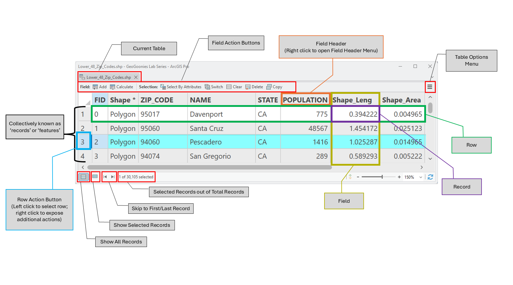 |
- Attribute tables are available for viewing and editing for each layer in ArcMap. They can be opened by right-clicking on the layer's name in the Content Pane and selecting "Open Attribute Table".
- All attribute tables are made up of rows, which run left to right, and columns, which run up and down and go by the proper GIS word, field.
- Vector data is a combination of the object (polygon, polyline, or point) seen in the map - known as the feature, and a corresponding row in the attribute table, which contains the non-spatial information about it. For example, you may see the outline of Colorado in the map, and the attribute table will have a single row with the name of the state, the time zone it falls in, and it's population at the last census.
- With vector data, the words “row” and “feature” are often used interchangeably, since there is only one feature per row.
- Each value in a classified raster is represented with one row of an attribute table. This means that raster files have attribute tables, too, but instead of one row for each pixel, each group of pixels have a row. For example, all the pixels which are classified into the urban category are represented with one row in the attribute table.
- Each field has a heading (name of the field) which is made up of alpha-numeric characters only and has no spaces. This means each column (field) has a unique name made up of only letters and numbers and cannot have any spaces.
- Each cell (where the row and field intersect) contains one and only one value, or record. This means that for each feature, there is only one record for each field. Colorado only has one name (Colorado, FYI), so the only thing which will appear in the NAME field for the row which corresponds with the Colorado shape on the map is Colorado.
- Record values are case sensitive and spelling dependent, meaning “california” is not the same value as “California” nor “Kalifornia”. An attribute table will see these as three separate values, because remember, your computer is stupid and cannot read or comprehend. It can only match what you type in a box to what it "sees" in a table. If you tell ArcGIS to search for the name "California", it will not return any records where California is entered any other way except the way you typed it.
- Attribute tables associated with vector data contain the geometry of that layer (point, polyline, polygon) under the field heading of “Shape”. Each and every record in a single shapefile or feature class will have the same shape. It is impossible to have a shapefile which contains both polygons and polylines.
- Polygon and Polyline layers all have at least one of the following fields:
- Shape_Length (polylines and polygons): The linear measurement of each feature
- Shape_Area (polygons): The area measure of each feature
- These are default fields and they are recorded in the measurement which was in place or defined in properties while the feature class was being created. That means that if your created your polygon file in decimal degrees, it will record the shape area as decimal degrees.
- Every table has a unique identifier row, often called OID or FID, containing a unique value that is not shared by any other feature in the table.
- OID = Object Identifier; FID = Feature Identifier
- FID is an identifier reserved for geometric features, where OID can be used for tables (non-spatial) or features, which means that geometric features (polyline, polygon, and point shapefiles/feature classes) can have either one, so you shouldn’t worry too much about which one you have, just that they serve the same purpose.
- In ArcGIS, there are two main action menus associated with attribute tables - the field header menu and the table options menu. Almost every action you will ever do with tables will be contained in these two menus
- Field header menus contain actions that effect that field only while the table options menu contains actions that effect the entire table.
- Records can be edited (change or delete the value) by typing directly in the box or by using the field calculator feature found in the field header menu.
- In ArcGIS, attribute tables are opened by right clicking on the layer name in the Contents pane to open the layer options menu and selecting “Open Attribute Table”
- In ArcGIS Pro's Catalog view, the attribute tables can be viewed by changing the tab from “Geography” to “Table” in the Details pane.