Since ArcGIS is a database electronic storage container with a top-down structure in which the items contained are related to each other and that relationship allows for the data to be quickly and efficiently queried and retrieved for use. program, and because databases have strict rules for file names, ArcGIS also enforces some pretty strict file naming conventions.
| The first rule of naming files in ArcGIS is: | no spaces and no special characters (except an underscore _ ).
|
 |
| The second rule of naming files in ArcGIS is: | no spaces and no special characters (except an underscore). There are three exceptions to this rule:
|
|
| The third rule of file naming in ArcGIS: | Do not start file names, field headings, folder names, or MXD names with a number or underscore
|
|
| Geodatabase Rules |
|
|
| Shapefile Rules | Shapefile name length: 10 characters | |
| Raster Rules |
|
|
4.6.2: Saving Properly When Running the [insert name here] Tool
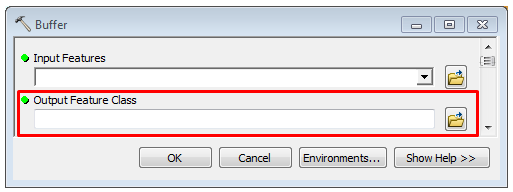
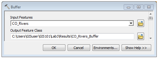
Every time you run a tool in ArcGIS, there will be an "Output Location" box. This box is tells ArcGIS where to save the output of the tool after it runs. Since we know the second function of our "Results" folder is a place to save the output from any tool you may run, we already know the path to save to. To designate a place to save the output, click on the folder icon ![]() to the left of the input box and drive to your results folder (keep opening folders until you get to your destination).
to the left of the input box and drive to your results folder (keep opening folders until you get to your destination).
Once you’ve opened your results folder, you need to give your output file a memorable and meaningful name. ArcGIS will default to the name of the tool (buffer, clip, erase, etc) appended to the original file name, which is neither memorable or meaningful. It is your job, nay, your duty, to rename the file according to your goal and task at hand, for example, "River_Buffer_50_meters".
| Figure 4.15: The Buffer Tool Dialog Box Showing the "Output Feature Class" Box Blank and Filled In. | |
|---|---|
 |
 |
4.6.3: Default Geodatabase
ArcGIS creates a default geodatabase electronic storage container specifically used to store geographic/ spatial data Data that deals with location, such as lists of addresses, the footprint of a building, the boundaries of cities and counties, etc. with a top-down structure in which the items contained are related to each other and that relationship allows for the data to be quickly and efficiently queried and retrieved for use. for each user of the computer in their "C:\Users\username\Documents folder. The purpose is to create a default place to save the output from geoprocessing tools (the tools we use in ArcGIS to analyze our data). Since ArcGIS really wants you to work with the geodatabase electronic storage container specifically used to store geographic/ spatial data Data that deals with location, such as lists of addresses, the footprint of a building, the boundaries of cities and counties, etc. with a top-down structure in which the items contained are related to each other and that relationship allows for the data to be quickly and efficiently queried and retrieved for use. format over a folder based system, it sets itself up from the beginning to use such a system. A good practice is to re-assign the default geodatabase electronic storage container specifically used to store geographic/ spatial data Data that deals with location, such as lists of addresses, the footprint of a building, the boundaries of cities and counties, etc. with a top-down structure in which the items contained are related to each other and that relationship allows for the data to be quickly and efficiently queried and retrieved for use. for each project to either the geodatabase electronic storage container specifically used to store geographic/ spatial data Data that deals with location, such as lists of addresses, the footprint of a building, the boundaries of cities and counties, etc. with a top-down structure in which the items contained are related to each other and that relationship allows for the data to be quickly and efficiently queried and retrieved for use. for that specific project or a catch-all default geodatabase electronic storage container specifically used to store geographic/ spatial data Data that deals with location, such as lists of addresses, the footprint of a building, the boundaries of cities and counties, etc. with a top-down structure in which the items contained are related to each other and that relationship allows for the data to be quickly and efficiently queried and retrieved for use. saved somewhere other than the default location.
One of the most common mistakes new
GIS
Geographic Information Systems
the software used to create, store, and manage
spatial data
Data that deals with location, such as lists of addresses, the footprint of a building, the boundaries of cities and counties, etc.
, analyze spatial problems, and display the data in cartographic layouts
Geographic Information Sciences
technicians make is clicking too fast and not assigning an location or memorable and meaningful name to the tool output, which leads to a whole series of "lost" data all named "Export_Output1", "River_Buff_Diss_1", and the super helpful "Export_Output2" ![]() . Until you memorize where the default
geodatabase
electronic storage container specifically used to store geographic/
spatial data
Data that deals with location, such as lists of addresses, the footprint of a building, the boundaries of cities and counties, etc.
with a top-down structure in which the items contained are related to each other and that relationship allows for the data to be quickly and efficiently queried and retrieved for use.
is on the computer as defined by ArcGIS, it will seem like all the data is "lost" or "just gone, I don't know what happened", yet its not really lost, it's just in the default
geodatabase
electronic storage container specifically used to store geographic/
spatial data
Data that deals with location, such as lists of addresses, the footprint of a building, the boundaries of cities and counties, etc.
with a top-down structure in which the items contained are related to each other and that relationship allows for the data to be quickly and efficiently queried and retrieved for use.
. One of the best moves you can make when you start a project is to re-assign that default
geodatabase
electronic storage container specifically used to store geographic/
spatial data
Data that deals with location, such as lists of addresses, the footprint of a building, the boundaries of cities and counties, etc.
with a top-down structure in which the items contained are related to each other and that relationship allows for the data to be quickly and efficiently queried and retrieved for use.
to one you know where it lives. In lab, you will create and use a default
geodatabase
electronic storage container specifically used to store geographic/
spatial data
Data that deals with location, such as lists of addresses, the footprint of a building, the boundaries of cities and counties, etc.
with a top-down structure in which the items contained are related to each other and that relationship allows for the data to be quickly and efficiently queried and retrieved for use.
saved right inside your GeoGoonies folder.
. Until you memorize where the default
geodatabase
electronic storage container specifically used to store geographic/
spatial data
Data that deals with location, such as lists of addresses, the footprint of a building, the boundaries of cities and counties, etc.
with a top-down structure in which the items contained are related to each other and that relationship allows for the data to be quickly and efficiently queried and retrieved for use.
is on the computer as defined by ArcGIS, it will seem like all the data is "lost" or "just gone, I don't know what happened", yet its not really lost, it's just in the default
geodatabase
electronic storage container specifically used to store geographic/
spatial data
Data that deals with location, such as lists of addresses, the footprint of a building, the boundaries of cities and counties, etc.
with a top-down structure in which the items contained are related to each other and that relationship allows for the data to be quickly and efficiently queried and retrieved for use.
. One of the best moves you can make when you start a project is to re-assign that default
geodatabase
electronic storage container specifically used to store geographic/
spatial data
Data that deals with location, such as lists of addresses, the footprint of a building, the boundaries of cities and counties, etc.
with a top-down structure in which the items contained are related to each other and that relationship allows for the data to be quickly and efficiently queried and retrieved for use.
to one you know where it lives. In lab, you will create and use a default
geodatabase
electronic storage container specifically used to store geographic/
spatial data
Data that deals with location, such as lists of addresses, the footprint of a building, the boundaries of cities and counties, etc.
with a top-down structure in which the items contained are related to each other and that relationship allows for the data to be quickly and efficiently queried and retrieved for use.
saved right inside your GeoGoonies folder.
ArcGIS Help Article on Default Geodatabases
Since ArcGIS is a database electronic storage container with a top-down structure in which the items contained are related to each other and that relationship allows for the data to be quickly and efficiently queried and retrieved for use. program, and because databases have strict rules for file names, ArcGIS also enforces some pretty strict file naming conventions.