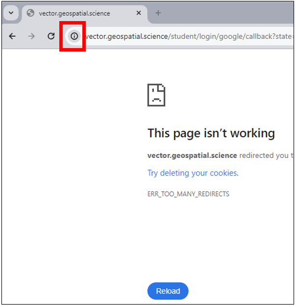
Login Redirect Error Workaround
If Chrome is saying: "vector.geospatial.science redirected you too many times. Try deleting your cookies. ERR_TOO_MANY_REDIRECTS." after clicking the Login button, do the following to fix it.
|  |
|  |
|  |
|  |
|  |
Datums
| Datum Name | WKID | Spheroid Name |
|---|---|---|
| 1_Ceres_2015 | 106972 | 1_Ceres_2015 |
| 4_Vesta_2015 | 106973 | 4_Vesta_2015 |
| D_Abidjan_1987 | 6143 | Clarke_1880_RGS |
| AbInvA96_2020_Intermediate_Reference_Frame | 1273 | GRS_1980 |
| D_Accra | 6168 | War_Office |
| D_Aden_1925 | 1135 | Clarke_1880_RGS |
| D_Adindan | 6201 | Clarke_1880_RGS |
| D_Adrastea_2000 | 106909 | Adrastea_2000_IAU_IAG |
| D_Afgooye | 6205 | Krasovsky_1940 |
| D_Agadez | 6206 | Clarke_1880_IGN |
| D_Ain_el_Abd_1970 | 6204 | International_1924 |
| D_Airy_1830 | 6001 | Airy_1830 |
| D_Airy_Modified | 6002 | Airy_Modified |
| D_Alaskan_Islands | 106260 | Clarke_1866 |
| D_Albanian_1987 | 6191 | Krasovsky_1940 |
| D_Amalthea_2000 | 106910 | Amalthea_2000_IAU_IAG |
| D_American_Samoa_1962 | 6169 | Clarke_1866 |
| D_Amersfoort | 6289 | Bessel_1841 |
| D_Ammassalik_1958 | 6196 | International_1924 |
| D_Ananke_2000 | 106911 | Ananke_2000_IAU_IAG |
| D_Anguilla_1957 | 6600 | Clarke_1880_RGS |
| D_Anna_1_1965 | 6708 | Australian |
| D_Antigua_1943 | 6601 | Clarke_1880_RGS |
| D_Aratu | 6208 | International_1924 |
| D_Arc_1950 | 6209 | Clarke_1880_Arc |
| D_Arc_1960 | 6210 | Clarke_1880_RGS |
| D_Ariel_2000 | 106945 | Ariel_2000_IAU_IAG |
| D_Ascension_Island_1958 | 6712 | International_1924 |
| D_Astro_1952 | 6711 | International_1924 |
| D_ATF | 6901 | Plessis_1817 |
| D_Atlas_2000 | 106926 | Atlas_2000_IAU_IAG |
| D_ATS_1977 | 6122 | ATS_1977 |
| D_Australian | 6003 | Australian |
| D_Australian_1966 | 6202 | Australian |
| D_Australian_1984 | 6203 | Australian |
| D_Australian_Antarctic_1998 | 6176 | GRS_1980 |
| Australian_Terrestrial_Reference_Frame_2014 | 1291 | GRS_1980 |
| D_Ayabelle | 6713 | Clarke_1880_RGS |
| D_Azores_Central_Islands_1948 | 6183 | International_1924 |
| D_Azores_Central_Islands_1995 | 6665 | International_1924 |
| D_Azores_Occidental_Islands_1939 | 6182 | International_1924 |
| D_Azores_Oriental_Islands_1940 | 6184 | International_1924 |
| D_Azores_Oriental_Islands_1995 | 6664 | International_1924 |
| D_Bab_South | 106269 | Clarke_1866 |
| D_Barbados_1938 | 6212 | Clarke_1880_RGS |
| D_Batavia | 6211 | Bessel_1841 |
| D_Beacon_E_1945 | 6709 | International_1924 |
| D_Beduaram | 6213 | Clarke_1880_IGN |
| D_Beijing_1954 | 6214 | Krasovsky_1940 |
| D_Bekaa_Valley_1920 | 1137 | Clarke_1880_RGS |
| D_Belge_1950 | 6215 | International_1924 |
| D_Belge_1972 | 6313 | International_1924 |
| D_Belinda_2000 | 106946 | Belinda_2000_IAU_IAG |
| D_Bellevue_IGN | 6714 | International_1924 |
| D_Bermuda_1957 | 6216 | Clarke_1866 |
| D_Bermuda_2000 | 6762 | WGS_1984 |
| D_Bern_1898 | 6217 | Bessel_1841 |
| D_Bern_1938 | 6306 | Bessel_1841 |
| D_Bessel_1841 | 6004 | Bessel_1841 |
| D_Bessel_Modified | 6005 | Bessel_Modified |
| D_Bessel_Namibia | 6006 | Bessel_Namibia |
| D_Bhutan_National_Geodetic_Datum | 1058 | GRS_1980 |
| D_Bianca_2000 | 106947 | Bianca_2000_IAU_IAG |
| D_Bioko | 1136 | International_1924 |
| D_Bissau | 6165 | International_1924 |
| D_Bogota | 6218 | International_1924 |
| D_Bukit_Rimpah | 6219 | Bessel_1841 |
| Bulgaria_Geodetic_System_2005 | 1167 | GRS_1980 |
| D_Cadastre_1997 | 1037 | International_1924 |
| California_SRS_Epoch_2017.50_(NAD83) | 106012 | GRS_1980 |
| D_Callisto_2000 | 106912 | Callisto_2000_IAU_IAG |
| D_Calypso_2000 | 106927 | Calypso_2000_IAU_IAG |
| D_Camacupa | 6220 | Clarke_1880_RGS |
| Camacupa_2015 | 1217 | Clarke_1880_RGS |
| D_Camp_Area | 6715 | International_1924 |
| D_Campo_Inchauspe | 6221 | International_1924 |
| D_Canton_1966 | 6716 | International_1924 |
| D_Cape | 6222 | Clarke_1880_Arc |
| D_Cape_Canaveral | 6717 | Clarke_1866 |
| D_Carme_2000 | 106913 | Carme_2000_IAU_IAG |
| D_Carthage | 6223 | Clarke_1880_IGN |
| D_Cayman_Islands_Geodetic_Datum_2011 | 1100 | GRS_1980 |
| D_CH1903 | 6149 | Bessel_1841 |
| D_CH1903+ | 6150 | Bessel_1841 |
| D_Charon_2000 | 106970 | Charon_2000_IAU_IAG |
| D_Chatham_Island_1971 | 6672 | International_1924 |
| D_Chatham_Islands_1979 | 6673 | International_1924 |
| D_China_2000 | 1043 | CGCS2000 |
| D_Chos_Malal_1914 | 6160 | International_1924 |
| D_Chua | 6224 | International_1924 |
| D_Clarke_1858 | 6007 | Clarke_1858 |
| D_Clarke_1866 | 6008 | Clarke_1866 |
| D_Clarke_1866_Michigan | 6009 | Clarke_1866_Michigan |
| D_Clarke_1880 | 6034 | Clarke_1880 |
| D_Clarke_1880_Arc | 6013 | Clarke_1880_Arc |
| D_Clarke_1880_Benoit | 6010 | Clarke_1880_Benoit |
| D_Clarke_1880_IGN | 6011 | Clarke_1880_IGN |
| D_Clarke_1880_RGS | 6012 | Clarke_1880_RGS |
| D_Clarke_1880_SGA | 6014 | Clarke_1880_SGA |
| D_Combani_1950 | 6632 | International_1924 |
| D_Conakry_1905 | 6315 | Clarke_1880_IGN |
| D_Cordelia_2000 | 106948 | Cordelia_2000_IAU_IAG |
| D_Corrego_Alegre | 6225 | International_1924 |
| D_Corrego_Alegre_1961 | 1074 | International_1924 |
| D_Costa_Rica_2005 | 1065 | WGS_1984 |
| D_Cote_d_Ivoire | 6226 | Clarke_1880_IGN |
| D_Cressida_2000 | 106949 | Cressida_2000_IAU_IAG |
| D_Croatian_Terrestrial_Reference_System | 6761 | GRS_1980 |
| CR-SIRGAS | 1225 | GRS_1980 |
| D_CSG_1967 | 6623 | International_1924 |
| D_Cyprus_Geodetic_Reference_System_1993 | 1112 | WGS_1984 |
| D_D48 | 106278 | Bessel_1841 |
| D_Dabola_1981 | 6155 | Clarke_1880_IGN |
| D_Datum_73 | 6274 | International_1924 |
| D_Datum_Geodesi_Nasional_1995 | 6755 | WGS_1984 |
| D_Datum_Lisboa_Bessel | 106262 | Bessel_1841 |
| D_Datum_Lisboa_Hayford | 106263 | International_1924 |
| D_Dealul_Piscului_1933 | 6316 | International_1924 |
| D_Dealul_Piscului_1970 | 6317 | Krasovsky_1940 |
| D_Deception_Island | 6736 | Clarke_1880_RGS |
| D_Deimos_2000 | 106906 | Deimos_2000_IAU_IAG |
| D_Deir_ez_Zor | 6227 | Clarke_1880_IGN |
| D_Desdemona_2000 | 106950 | Desdemona_2000_IAU_IAG |
| D_Despina_2000 | 106961 | Despina_2000_IAU_IAG |
| D_Deutsche_Bahn_Reference_System | 1081 | Bessel_1841 |
| D_Deutsches_Hauptdreiecksnetz | 6314 | Bessel_1841 |
| D_Dione_2000 | 106928 | Dione_2000_IAU_IAG |
| D_Dominica_1945 | 6602 | Clarke_1880_RGS |
| D_DOS_1968 | 106218 | International_1924 |
| D_DOS_71_4 | 6710 | International_1924 |
| D_Douala | 6228 | Clarke_1880_IGN |
| D_Douala_1948 | 6192 | International_1924 |
| D_Easter_Island_1967 | 6719 | International_1924 |
| ECML14_NB_Intermediate_Reference_Frame | 1310 | GRS_1980 |
| D_Egypt_1907 | 6229 | Helmert_1906 |
| D_Egypt_1930 | 6199 | International_1924 |
| D_Egypt_Gulf_of_Suez_S-650_TL | 6706 | Helmert_1906 |
| D_Elara_2000 | 106914 | Elara_2000_IAU_IAG |
| D_Enceladus_2000 | 106929 | Enceladus_2000_IAU_IAG |
| EOS21_Intermediate_Reference_Frame | 1308 | GRS_1980 |
| D_Epimetheus_2000 | 106930 | Epimetheus_2000_IAU_IAG |
| D_Estonia_1937 | 106101 | Bessel_1841 |
| D_Estonia_1992 | 6133 | GRS_1980 |
| D_Estonia_1997 | 6180 | GRS_1980 |
| D_ETRF_1989 | 1178 | WGS_1984 |
| ETRF2000_Poland | 1305 | GRS_1980 |
| D_ETRS_1989 | 6258 | GRS_1980 |
| D_Europa_2000 | 106915 | Europa_2000_IAU_IAG |
| D_European_1950 | 6230 | International_1924 |
| D_European_1950_ED77 | 6154 | International_1924 |
| D_European_1979 | 6668 | International_1924 |
| D_European_1987 | 6231 | International_1924 |
| D_European_Libyan_1979 | 6159 | International_1924 |
| European_Terrestrial_Reference_Frame_1990 | 1179 | GRS_1980 |
| European_Terrestrial_Reference_Frame_1991 | 1180 | GRS_1980 |
| European_Terrestrial_Reference_Frame_1992 | 1181 | GRS_1980 |
| European_Terrestrial_Reference_Frame_1993 | 1182 | GRS_1980 |
| European_Terrestrial_Reference_Frame_1994 | 1183 | GRS_1980 |
| European_Terrestrial_Reference_Frame_1996 | 1184 | GRS_1980 |
| European_Terrestrial_Reference_Frame_1997 | 1185 | GRS_1980 |
| European_Terrestrial_Reference_Frame_2000 | 1186 | GRS_1980 |
| European_Terrestrial_Reference_Frame_2005 | 1204 | GRS_1980 |
| European_Terrestrial_Reference_Frame_2014 | 1206 | GRS_1980 |
| D_Everest_1830 | 6042 | Everest_1830 |
| D_Everest_Adj_1937 | 6015 | Everest_Adjustment_1937 |
| D_Everest_Bangladesh | 106202 | Everest_Adjustment_1937 |
| D_Everest_Def_1962 | 6044 | Everest_Definition_1962 |
| D_Everest_Def_1967 | 6016 | Everest_Definition_1967 |
| D_Everest_Def_1975 | 6045 | Everest_Definition_1975 |
| D_Everest_India_Nepal | 106203 | Everest_Definition_1962 |
| D_Everest_Modified | 6018 | Everest_1830_Modified |
| D_Everest_Modified_1969 | 106006 | Everest_Modified_1969 |
| EWR2_Intermediate_Reference_Frame | 1311 | GRS_1980 |
| D_Fahud | 6232 | Clarke_1880_RGS |
| D_Faroe_Datum_1954 | 6741 | International_1924 |
| D_Fatu_Iva_1972 | 6688 | International_1924 |
| D_FD_1958 | 6132 | Clarke_1880_RGS |
| D_Fehmarnbelt_Datum_2010 | 1078 | GRS_1980 |
| D_Fiji_1956 | 6721 | International_1924 |
| D_Fiji_1986 | 6720 | WGS_1972 |
| D_Fischer_1960 | 106002 | Fischer_1960 |
| D_Fischer_1968 | 106003 | Fischer_1968 |
| D_Fischer_Modified | 106004 | Fischer_Modified |
| D_fk89 | 6753 | International_1924 |
| D_Fort_Desaix | 6625 | International_1924 |
| D_Fort_Marigot | 6621 | International_1924 |
| D_Fort_Thomas_1955 | 106240 | Clarke_1880_RGS |
| D_Galatea_2000 | 106962 | Galatea_2000_IAU_IAG |
| D_Gambia | 1139 | Clarke_1880_RGS |
| D_Gan_1970 | 6684 | International_1924 |
| D_Ganymede_2000 | 106916 | Ganymede_2000_IAU_IAG |
| D_Garoua | 6197 | Clarke_1880_RGS |
| GBK19_Intermediate_Reference_Frame | 1289 | GRS_1980 |
| D_GDA_1994 | 6283 | GRS_1980 |
| GDA2020 | 1168 | GRS_1980 |
| D_GDBD2009 | 1056 | GRS_1980 |
| D_GDM_2000 | 6742 | GRS_1980 |
| D_GEM_10C | 6031 | GEM_10C |
| Geocentric_Datum_of_Mauritius_2008 | 106028 | GRS_1980 |
| Geodezicheskaya_Sistema_Koordinat_2011 | 1159 | GSK-2011 |
| Georgia_Geodetic_Datum | 106010 | GRS_1980 |
| D_GGRS_1987 | 6121 | GRS_1980 |
| D_Graciosa_Base_SW_1948 | 106241 | International_1924 |
| D_Grand_Cayman_1959 | 6723 | Clarke_1866 |
| D_Grand_Comoros | 6646 | International_1924 |
| D_Greek | 6120 | Bessel_1841 |
| D_Greenland_1996 | 6747 | GRS_1980 |
| D_Grenada_1953 | 6603 | Clarke_1880_RGS |
| D_GRS_1967 | 6036 | GRS_1967 |
| D_GRS_1980 | 6019 | GRS_1980 |
| D_Guam_1963 | 6675 | Clarke_1866 |
| D_Gulshan_303 | 6682 | Everest_Adjustment_1937 |
| D_Gunung_Segara | 6613 | Bessel_1841 |
| Gusterberg_(Ferro) | 1188 | Zach_1812 |
| D_GUX_1 | 106221 | International_1924 |
| D_Guyane_Francaise | 6235 | International_1924 |
| D_Hanoi_1972 | 6147 | Krasovsky_1940 |
| D_Hartebeesthoek_1994 | 6148 | WGS_1984 |
| D_Helene_2000 | 106931 | Helene_2000_IAU_IAG |
| D_Helle_1954 | 6660 | International_1924 |
| D_Helmert_1906 | 6020 | Helmert_1906 |
| D_Herat_North | 6255 | International_1924 |
| D_Hermannskogel | 106102 | Bessel_1841 |
| D_Himalia_2000 | 106917 | Himalia_2000_IAU_IAG |
| D_Hito_XVIII_1963 | 6254 | International_1924 |
| D_Hjorsey_1955 | 6658 | International_1924 |
| D_Hong_Kong_1963 | 6738 | Clarke_1858 |
| D_Hong_Kong_1963_67 | 6739 | International_1924 |
| D_Hong_Kong_1980 | 6611 | International_1924 |
| Hong_Kong_Geodetic | 1209 | GRS_1980 |
| D_Hough_1960 | 106005 | Hough_1960 |
| HS2_Intermediate_Reference_Frame | 1264 | GRS_1980 |
| D_Hughes_1980 | 6054 | Hughes_1980 |
| D_Hungarian_1972 | 6237 | GRS_1967 |
| D_Hungarian_Datum_1909 | 1024 | Bessel_1841 |
| D_Hu_Tzu_Shan | 6236 | International_1924 |
| D_Hyperion_2000 | 106932 | Hyperion_2000_IAU_IAG |
| D_Iapetus_2000 | 106933 | Iapetus_2000_IAU_IAG |
| IG05(2012)_Intermediate_Datum | 1144 | GRS_1980 |
| IG05_Intermediate_Datum | 1142 | GRS_1980 |
| IGb00 | 1246 | GRS_1980 |
| IGb08 | 1248 | GRS_1980 |
| IGb14 | 1272 | GRS_1980 |
| D_IGC_1962_Arc_of_the_6th_Parallel_South | 6697 | Clarke_1880_RGS |
| D_IGM_1995 | 6670 | WGS_1984 |
| D_IGN53_Mare | 6641 | International_1924 |
| D_IGN56_Lifou | 6633 | International_1924 |
| D_IGN63_Hiva_Oa | 6689 | International_1924 |
| D_IGN72_Grande_Terre | 6634 | International_1924 |
| D_IGN72_Nuku_Hiva | 6630 | International_1924 |
| D_IGN_Astro_1960 | 6700 | Clarke_1880_RGS |
| IGS00 | 1245 | GRS_1980 |
| IGS05 | 1247 | GRS_1980 |
| IGS08 | 1141 | GRS_1980 |
| IGS14 | 1191 | GRS_1980 |
| IGS97 | 1244 | GRS_1980 |
| D_Indian_1954 | 6239 | Everest_Adjustment_1937 |
| D_Indian_1960 | 6131 | Everest_Adjustment_1937 |
| D_Indian_1975 | 6240 | Everest_Adjustment_1937 |
| D_Indonesian | 6021 | Indonesian |
| D_Indonesian_1974 | 6238 | Indonesian |
| D_Institut_Geographique_du_Congo_Belge_1955 | 6701 | Clarke_1880_RGS |
| D_International_1924 | 6022 | International_1924 |
| D_International_1967 | 6023 | International_1967 |
| International_Terrestrial_Reference_Frame_2014 | 1165 | GRS_1980 |
| D_Io_2000 | 106918 | Io_2000_IAU_IAG |
| D_Iraqi_Geospatial_Reference_System | 1029 | GRS_1980 |
| D_Iraq_Kuwait_Boundary_1992 | 6667 | WGS_1984 |
| D_IRENET95 | 6173 | GRS_1980 |
| D_Islands_Network_1993 | 6659 | GRS_1980 |
| D_Islands_Network_2004 | 1060 | GRS_1980 |
| Islands_Net_2016 | 1187 | GRS_1980 |
| D_Israel | 6141 | GRS_1980 |
| Israel_Geodetic_Datum_2005 | 1114 | GRS_1980 |
| Israeli_Geodetic_Datum_2005(2012) | 1115 | GRS_1980 |
| D_ISTS_061_1968 | 6722 | International_1924 |
| D_ISTS_073_1969 | 6724 | International_1924 |
| D_ITRF_1988 | 6647 | GRS_1980 |
| D_ITRF_1989 | 6648 | GRS_1980 |
| D_ITRF_1990 | 6649 | GRS_1980 |
| D_ITRF_1991 | 6650 | GRS_1980 |
| D_ITRF_1992 | 6651 | GRS_1980 |
| D_ITRF_1993 | 6652 | GRS_1980 |
| D_ITRF_1994 | 6653 | GRS_1980 |
| D_ITRF_1996 | 6654 | GRS_1980 |
| D_ITRF_1997 | 6655 | GRS_1980 |
| D_ITRF_2000 | 6656 | GRS_1980 |
| D_ITRF_2005 | 6896 | GRS_1980 |
| D_ITRF_2008 | 1061 | GRS_1980 |
| D_Jamaica_1875 | 6241 | Clarke_1880 |
| D_Jamaica_1969 | 6242 | Clarke_1866 |
| D_Jamaica_2001 | 6758 | WGS_1984 |
| D_Janus_2000 | 106934 | Janus_2000_IAU_IAG |
| D_JGD_2000 | 6612 | GRS_1980 |
| D_JGD_2011 | 1128 | GRS_1980 |
| D_Johnston_Island_1961 | 6725 | International_1924 |
| D_Jordan | 106277 | International_1924 |
| D_Jouik_1961 | 6679 | Clarke_1880_RGS |
| D_Juliet_2000 | 106951 | Juliet_2000_IAU_IAG |
| D_Jupiter_2000 | 106908 | Jupiter_2000_IAU_IAG |
| D_Kalianpur_1880 | 6243 | Everest_1830 |
| D_Kalianpur_1937 | 6144 | Everest_Adjustment_1937 |
| D_Kalianpur_1962 | 6145 | Everest_Definition_1962 |
| D_Kalianpur_1975 | 6146 | Everest_Definition_1975 |
| D_Kandawala | 6244 | Everest_Adjustment_1937 |
| D_Karbala_1979_Polservice | 6743 | Clarke_1880_RGS |
| D_Kasai_1953 | 6696 | Clarke_1880_RGS |
| D_Katanga_1955 | 6695 | Clarke_1866 |
| D_Kerguelen_Island_1949 | 6698 | International_1924 |
| D_Kertau | 6245 | Everest_1830_Modified |
| D_Kertau_RSO | 6751 | Everest_Modified_1969 |
| Kingdom_of_Saudi_Arabia_Geodetic_Reference_ Frame_2017 |
1268 | GRS_1980 |
| D_KKJ | 6123 | International_1924 |
| D_Korea_2000 | 6737 | GRS_1980 |
| D_Korean_Datum_1985 | 6162 | Bessel_1841 |
| D_Korean_Datum_1995 | 6166 | WGS_1984 |
| Kosovo_Reference_System_2001 | 1251 | GRS_1980 |
| D_Kousseri | 6198 | Clarke_1880_RGS |
| D_Krasovsky_1940 | 6024 | Krasovsky_1940 |
| D_Kusaie_1951 | 6735 | International_1924 |
| D_Kuwait_Oil_Company | 6246 | Clarke_1880_RGS |
| D_Kuwait_Utility | 6319 | GRS_1980 |
| D_Kyrgyz_Republic_2006 | 106009 | GRS_1980 |
| D_La_Canoa | 6247 | International_1924 |
| D_Lake | 6249 | International_1924 |
| D_Lao_1993 | 6677 | Krasovsky_1940 |
| D_Lao_National_Datum_1997 | 6678 | Krasovsky_1940 |
| D_Larissa_2000 | 106963 | Larissa_2000_IAU_IAG |
| D_Latvia_1992 | 6661 | GRS_1980 |
| D_LC5_1961 | 106243 | Clarke_1866 |
| D_Leda_2000 | 106919 | Leda_2000_IAU_IAG |
| D_Leigon | 6250 | Clarke_1880_RGS |
| D_Le_Pouce_1934 | 6699 | Clarke_1880_RGS |
| D_Liberia_1964 | 6251 | Clarke_1880_RGS |
| D_Libyan_Geodetic_Datum_2006 | 6754 | International_1924 |
| D_Lisbon | 6207 | International_1924 |
| D_Lisbon_1890 | 6666 | Bessel_1841 |
| D_Lithuania_1994 | 6126 | GRS_1980 |
| D_Little_Cayman_1961 | 6726 | Clarke_1866 |
| D_Locodjo_1965 | 6142 | Clarke_1880_RGS |
| D_Loma_Quintana | 6288 | International_1924 |
| D_Lome | 6252 | Clarke_1880_IGN |
| D_Luxembourg_1930 | 6181 | International_1924 |
| D_Luzon_1911 | 6253 | Clarke_1866 |
| Lyon_Turin_Ferroviaire_2004 | 1295 | GRS_1980 |
| D_Lysithea_2000 | 106920 | Lysithea_2000_IAU_IAG |
| Macao_1920 | 1207 | International_1924 |
| D_MACAO_2008 | 1208 | International_1924 |
| D_Madeira_1936 | 6185 | International_1924 |
| D_Madrid_1870 | 6903 | Struve_1860 |
| D_Madzansua | 6128 | Clarke_1866 |
| D_MAGNA | 6686 | GRS_1980 |
| D_Mahe_1971 | 6256 | Clarke_1880_RGS |
| D_Majuro | 106270 | Clarke_1866 |
| D_Makassar | 6257 | Bessel_1841 |
| D_Malongo_1987 | 6259 | International_1924 |
| D_Manoca | 6260 | Clarke_1880_RGS |
| D_Manoca_1962 | 6193 | Clarke_1880_IGN |
| D_Marco_Geodesico_Nacional | 1063 | GRS_1980 |
| D_Mars_1979 | 106904 | Mars_1979_IAU_IAG |
| D_Mars_2000 | 106905 | Mars_2000_IAU_IAG |
| Mars_2000_(Sphere) | 106971 | Mars_2000_(Sphere) |
| D_Massawa | 6262 | Bessel_1841 |
| D_Maupiti_1983 | 6692 | International_1924 |
| D_Mauritania_1999 | 6702 | GRS_1980 |
| D_Merchich | 6261 | Clarke_1880_IGN |
| D_Mercury_2000 | 106900 | Mercury_2000_IAU_IAG |
| Mercury_2015 | 106974 | Mercury_2015 |
| D_Metis_2000 | 106921 | Metis_2000_IAU_IAG |
| D_Mexican_Datum_of_1993 | 1042 | GRS_1980 |
| D_Mexico_ITRF2008 | 1120 | GRS_1980 |
| D_MGI | 6312 | Bessel_1841 |
| D_MGI_1901 | 1031 | Bessel_1841 |
| D_Mhast_1951 | 6703 | Clarke_1880_RGS |
| D_Mhast_Offshore | 6705 | International_1924 |
| D_Mhast_Onshore | 6704 | International_1924 |
| D_Midway_1961 | 6727 | International_1924 |
| D_Mimas_2000 | 106935 | Mimas_2000_IAU_IAG |
| Ministerio_de_Marina_Norte | 1258 | International_1924 |
| Ministerio_de_Marina_Sur | 1259 | International_1924 |
| D_Minna | 6263 | Clarke_1880_RGS |
| D_Miranda_2000 | 106952 | Miranda_2000_IAU_IAG |
| MML07_Intermediate_Reference_Frame | 1271 | GRS_1980 |
| D_MOLDREF99 | 1032 | GRS_1980 |
| MOMRA_Terrestrial_Reference_Frame_2000 | 1218 | GRS_1980 |
| D_Monte_Mario | 6265 | International_1924 |
| D_Montserrat_1958 | 6604 | Clarke_1880_RGS |
| D_Moon_2000 | 106903 | Moon_2000_IAU_IAG |
| D_Moorea_1987 | 6691 | International_1924 |
| D_MOP78 | 6639 | International_1924 |
| D_Mount_Dillon | 6157 | Clarke_1858 |
| D_Moznet | 6130 | WGS_1984 |
| D_Mporaloko | 6266 | Clarke_1880_IGN |
| D_NAD_1927_CGQ77 | 6609 | Clarke_1866 |
| D_NAD_1927_Definition_1976 | 6608 | Clarke_1866 |
| NAD_1983_(Federal_Base_Network) | 1211 | GRS_1980 |
| NAD_1983_(High_Accuracy_Reference_Network- Corrected) | 1212 | GRS_1980 |
| D_NAD_1983_2011 | 1116 | GRS_1980 |
| D_NAD_1983_CORS96 | 1133 | GRS_1980 |
| North_American_Datum_of_1983_(CSRS96) | 1192 | GRS_1980 |
| North_American_Datum_of_1983_(CSRS)_version_2 | 1193 | GRS_1980 |
| North_American_Datum_of_1983_(CSRS)_version_3 | 1194 | GRS_1980 |
| North_American_Datum_of_1983_(CSRS)_version_4 | 1195 | GRS_1980 |
| North_American_Datum_of_1983_(CSRS)_version_5 | 1196 | GRS_1980 |
| North_American_Datum_of_1983_(CSRS)_version_6 | 1197 | GRS_1980 |
| North_American_Datum_of_1983_(CSRS)_version_7 | 1198 | GRS_1980 |
| D_NAD_1983_HARN_Adj_MN_Anoka | 106700 | S_GRS_1980_Adj_MN_Anoka |
| D_NAD_1983_HARN_Adj_MN_Becker | 106701 | S_GRS_1980_Adj_MN_Becker |
| D_NAD_1983_HARN_Adj_MN_Beltrami_North | 106702 | S_GRS_1980_Adj_MN_Beltrami_North |
| D_NAD_1983_HARN_Adj_MN_Beltrami_South | 106703 | S_GRS_1980_Adj_MN_Beltrami_South |
| D_NAD_1983_HARN_Adj_MN_Benton | 106704 | S_GRS_1980_Adj_MN_Benton |
| D_NAD_1983_HARN_Adj_MN_Big_Stone | 106705 | S_GRS_1980_Adj_MN_Big_Stone |
| D_NAD_1983_HARN_Adj_MN_Blue_Earth | 106706 | S_GRS_1980_Adj_MN_Blue_Earth |
| D_NAD_1983_HARN_Adj_MN_Brown | 106707 | S_GRS_1980_Adj_MN_Brown |
| D_NAD_1983_HARN_Adj_MN_Carlton | 106708 | S_GRS_1980_Adj_MN_Carlton |
| D_NAD_1983_HARN_Adj_MN_Carver | 106709 | S_GRS_1980_Adj_MN_Carver |
| D_NAD_1983_HARN_Adj_MN_Cass_North | 106710 | S_GRS_1980_Adj_MN_Cass_North |
| D_NAD_1983_HARN_Adj_MN_Cass_South | 106711 | S_GRS_1980_Adj_MN_Cass_South |
| D_NAD_1983_HARN_Adj_MN_Chippewa | 106712 | S_GRS_1980_Adj_MN_Chippewa |
| D_NAD_1983_HARN_Adj_MN_Chisago | 106713 | S_GRS_1980_Adj_MN_Chisago |
| D_NAD_1983_HARN_Adj_MN_Cook_North | 106714 | S_GRS_1980_Adj_MN_Cook_North |
| D_NAD_1983_HARN_Adj_MN_Cook_South | 106715 | S_GRS_1980_Adj_MN_Cook_South |
| D_NAD_1983_HARN_Adj_MN_Cottonwood | 106716 | S_GRS_1980_Adj_MN_Cottonwood |
| D_NAD_1983_HARN_Adj_MN_Crow_Wing | 106717 | S_GRS_1980_Adj_MN_Crow_Wing |
| D_NAD_1983_HARN_Adj_MN_Dakota | 106718 | S_GRS_1980_Adj_MN_Dakota |
| D_NAD_1983_HARN_Adj_MN_Dodge | 106719 | S_GRS_1980_Adj_MN_Dodge |
| D_NAD_1983_HARN_Adj_MN_Douglas | 106720 | S_GRS_1980_Adj_MN_Douglas |
| D_NAD_1983_HARN_Adj_MN_Faribault | 106721 | S_GRS_1980_Adj_MN_Faribault |
| D_NAD_1983_HARN_Adj_MN_Fillmore | 106722 | S_GRS_1980_Adj_MN_Fillmore |
| D_NAD_1983_HARN_Adj_MN_Freeborn | 106723 | S_GRS_1980_Adj_MN_Freeborn |
| D_NAD_1983_HARN_Adj_MN_Goodhue | 106724 | S_GRS_1980_Adj_MN_Goodhue |
| D_NAD_1983_HARN_Adj_MN_Grant | 106725 | S_GRS_1980_Adj_MN_Grant |
| D_NAD_1983_HARN_Adj_MN_Hennepin | 106726 | S_GRS_1980_Adj_MN_Hennepin |
| D_NAD_1983_HARN_Adj_MN_Houston | 106727 | S_GRS_1980_Adj_MN_Houston |
| D_NAD_1983_HARN_Adj_MN_Isanti | 106728 | S_GRS_1980_Adj_MN_Isanti |
| D_NAD_1983_HARN_Adj_MN_Itasca_North | 106729 | S_GRS_1980_Adj_MN_Itasca_North |
| D_NAD_1983_HARN_Adj_MN_Itasca_South | 106730 | S_GRS_1980_Adj_MN_Itasca_South |
| D_NAD_1983_HARN_Adj_MN_Jackson | 106731 | S_GRS_1980_Adj_MN_Jackson |
| D_NAD_1983_HARN_Adj_MN_Kanabec | 106732 | S_GRS_1980_Adj_MN_Kanabec |
| D_NAD_1983_HARN_Adj_MN_Kandiyohi | 106733 | S_GRS_1980_Adj_MN_Kandiyohi |
| D_NAD_1983_HARN_Adj_MN_Kittson | 106734 | S_GRS_1980_Adj_MN_Kittson |
| D_NAD_1983_HARN_Adj_MN_Koochiching | 106735 | S_GRS_1980_Adj_MN_Koochiching |
| D_NAD_1983_HARN_Adj_MN_Lac_Qui_Parle | 106736 | S_GRS_1980_Adj_MN_Lac_Qui_Parle |
| D_NAD_1983_HARN_Adj_MN_Lake_of_the_Woods _North |
106737 | S_GRS_1980_Adj_MN_Lake_of_the_Woods _North |
| D_NAD_1983_HARN_Adj_MN_Lake_of_the_Woods _South |
106738 | S_GRS_1980_Adj_MN_Lake_of_the_Woods _South |
| D_NAD_1983_HARN_Adj_MN_Le_Sueur | 106739 | S_GRS_1980_Adj_MN_Le_Sueur |
| D_NAD_1983_HARN_Adj_MN_Lincoln | 106740 | S_GRS_1980_Adj_MN_Lincoln |
| D_NAD_1983_HARN_Adj_MN_Lyon | 106741 | S_GRS_1980_Adj_MN_Lyon |
| D_NAD_1983_HARN_Adj_MN_Mahnomen | 106743 | S_GRS_1980_Adj_MN_Mahnomen |
| D_NAD_1983_HARN_Adj_MN_Marshall | 106744 | S_GRS_1980_Adj_MN_Marshall |
| D_NAD_1983_HARN_Adj_MN_Martin | 106745 | S_GRS_1980_Adj_MN_Martin |
| D_NAD_1983_HARN_Adj_MN_McLeod | 106742 | S_GRS_1980_Adj_MN_McLeod |
| D_NAD_1983_HARN_Adj_MN_Meeker | 106746 | S_GRS_1980_Adj_MN_Meeker |
| D_NAD_1983_HARN_Adj_MN_Morrison | 106747 | S_GRS_1980_Adj_MN_Morrison |
| D_NAD_1983_HARN_Adj_MN_Mower | 106748 | S_GRS_1980_Adj_MN_Mower |
| D_NAD_1983_HARN_Adj_MN_Murray | 106749 | S_GRS_1980_Adj_MN_Murray |
| D_NAD_1983_HARN_Adj_MN_Nicollet | 106750 | S_GRS_1980_Adj_MN_Nicollet |
| D_NAD_1983_HARN_Adj_MN_Nobles | 106751 | S_GRS_1980_Adj_MN_Nobles |
| D_NAD_1983_HARN_Adj_MN_Norman | 106752 | S_GRS_1980_Adj_MN_Norman |
| D_NAD_1983_HARN_Adj_MN_Olmsted | 106753 | S_GRS_1980_Adj_MN_Olmsted |
| D_NAD_1983_HARN_Adj_MN_Ottertail | 106754 | S_GRS_1980_Adj_MN_Ottertail |
| D_NAD_1983_HARN_Adj_MN_Pennington | 106755 | S_GRS_1980_Adj_MN_Pennington |
| D_NAD_1983_HARN_Adj_MN_Pine | 106756 | S_GRS_1980_Adj_MN_Pine |
| D_NAD_1983_HARN_Adj_MN_Pipestone | 106757 | S_GRS_1980_Adj_MN_Pipestone |
| D_NAD_1983_HARN_Adj_MN_Polk | 106758 | S_GRS_1980_Adj_MN_Polk |
| D_NAD_1983_HARN_Adj_MN_Pope | 106759 | S_GRS_1980_Adj_MN_Pope |
| D_NAD_1983_HARN_Adj_MN_Ramsey | 106760 | S_GRS_1980_Adj_MN_Ramsey |
| D_NAD_1983_HARN_Adj_MN_Red_Lake | 106761 | S_GRS_1980_Adj_MN_Red_Lake |
| D_NAD_1983_HARN_Adj_MN_Redwood | 106762 | S_GRS_1980_Adj_MN_Redwood |
| D_NAD_1983_HARN_Adj_MN_Renville | 106763 | S_GRS_1980_Adj_MN_Renville |
| D_NAD_1983_HARN_Adj_MN_Rice | 106764 | S_GRS_1980_Adj_MN_Rice |
| D_NAD_1983_HARN_Adj_MN_Rock | 106765 | S_GRS_1980_Adj_MN_Rock |
| D_NAD_1983_HARN_Adj_MN_Roseau | 106766 | S_GRS_1980_Adj_MN_Roseau |
| D_NAD_1983_HARN_Adj_MN_Scott | 106770 | S_GRS_1980_Adj_MN_Scott |
| D_NAD_1983_HARN_Adj_MN_Sherburne | 106771 | S_GRS_1980_Adj_MN_Sherburne |
| D_NAD_1983_HARN_Adj_MN_Sibley | 106772 | S_GRS_1980_Adj_MN_Sibley |
| D_NAD_1983_HARN_Adj_MN_Stearns | 106773 | S_GRS_1980_Adj_MN_Stearns |
| D_NAD_1983_HARN_Adj_MN_Steele | 106774 | S_GRS_1980_Adj_MN_Steele |
| D_NAD_1983_HARN_Adj_MN_Stevens | 106775 | S_GRS_1980_Adj_MN_Stevens |
| D_NAD_1983_HARN_Adj_MN_St_Louis | 106786 | S_GRS_1980_Adj_MN_St_Louis |
| D_NAD_1983_HARN_Adj_MN_St_Louis_Central | 106768 | S_GRS_1980_Adj_MN_St_Louis_Central |
| D_NAD_1983_HARN_Adj_MN_St_Louis_North | 106767 | S_GRS_1980_Adj_MN_St_Louis_North |
| D_NAD_1983_HARN_Adj_MN_St_Louis_South | 106769 | S_GRS_1980_Adj_MN_St_Louis_South |
| D_NAD_1983_HARN_Adj_MN_Swift | 106776 | S_GRS_1980_Adj_MN_Swift |
| D_NAD_1983_HARN_Adj_MN_Todd | 106777 | S_GRS_1980_Adj_MN_Todd |
| D_NAD_1983_HARN_Adj_MN_Traverse | 106778 | S_GRS_1980_Adj_MN_Traverse |
| D_NAD_1983_HARN_Adj_MN_Wabasha | 106779 | S_GRS_1980_Adj_MN_Wabasha |
| D_NAD_1983_HARN_Adj_MN_Wadena | 106780 | S_GRS_1980_Adj_MN_Wadena |
| D_NAD_1983_HARN_Adj_MN_Waseca | 106781 | S_GRS_1980_Adj_MN_Waseca |
| D_NAD_1983_HARN_Adj_MN_Watonwan | 106782 | S_GRS_1980_Adj_MN_Watonwan |
| D_NAD_1983_HARN_Adj_MN_Winona | 106783 | S_GRS_1980_Adj_MN_Winona |
| D_NAD_1983_HARN_Adj_MN_Wright | 106784 | S_GRS_1980_Adj_MN_Wright |
| D_NAD_1983_HARN_Adj_MN_Yellow_Medicine | 106785 | S_GRS_1980_Adj_MN_Yellow_Medicine |
| D_NAD_1983_HARN_Adj_WI_CP | 106806 | GRS_1980_Adj_WI_CP |
| D_NAD_1983_MA11 | 1118 | GRS_1980 |
| D_NAD_1983_MARP00 | 1221 | GRS_1980 |
| D_NAD_1983_NSRS2007 | 6759 | GRS_1980 |
| D_NAD_1983_PA11 | 1117 | GRS_1980 |
| D_NAD_1983_PACP00 | 1249 | GRS_1980 |
| D_Nahrwan_1934 | 6744 | Clarke_1880_RGS |
| D_Nahrwan_1967 | 6270 | Clarke_1880_RGS |
| D_Naiad_2000 | 106964 | Naiad_2000_IAU_IAG |
| D_Nakhl-e_Ghanem | 6693 | WGS_1984 |
| D_Naparima_1955 | 6158 | International_1924 |
| D_Naparima_1972 | 6271 | International_1924 |
| D_NEA74_Noumea | 6644 | International_1924 |
| D_Nepal_Nagarkot | 1111 | Everest_Adjustment_1937 |
| D_Neptune_2000 | 106960 | Neptune_2000_IAU_IAG |
| D_Nereid_2000 | 106965 | Nereid_2000_IAU_IAG |
| D_New_Beijing | 1045 | Krasovsky_1940 |
| D_New_Zealand_1949 | 6272 | International_1924 |
| D_NGN | 6318 | WGS_1984 |
| D_NGO_1948 | 6273 | Bessel_Modified |
| D_Nord_de_Guerre | 6902 | Plessis_1817 |
| D_Nord_Sahara_1959 | 6307 | Clarke_1880_RGS |
| D_North_American_1927 | 6267 | Clarke_1866 |
| D_North_American_1983 | 6269 | GRS_1980 |
| D_North_American_1983_CSRS | 6140 | GRS_1980 |
| D_North_American_1983_HARN | 6152 | GRS_1980 |
| D_North_American_Michigan | 6268 | Clarke_1866_Michigan |
| D_Nouakchott_1965 | 6680 | Clarke_1880_RGS |
| D_NSWC_9Z_2 | 6276 | NWL_9D |
| D_NTF | 6275 | Clarke_1880_IGN |
| D_NWL_9D | 6025 | NWL_9D |
| D_NZGD_2000 | 6167 | GRS_1980 |
| D_Oberon_2000 | 106953 | Oberon_2000_IAU_IAG |
| D_Observatario | 6129 | Clarke_1866 |
| D_Observatorio_Meteorologico_1939 | 106245 | International_1924 |
| D_Observatorio_Meteorologico_1965 | 106274 | International_1924 |
| D_Ocotepeque_1935 | 1070 | Clarke_1866 |
| D_Old_Hawaiian | 6135 | Clarke_1866 |
| D_Old_Hawaiian_Intl_1924 | 106284 | International_1924 |
| D_Oman | 106206 | Clarke_1880_RGS |
| Oman_National_Geodetic_Datum_2014 | 1147 | GRS_1980 |
| Oman_National_Geodetic_Datum_2017 | 1263 | GRS_1980 |
| D_Ophelia_2000 | 106954 | Ophelia_2000_IAU_IAG |
| D_OSGB_1936 | 6277 | Airy_1830 |
| D_OSGB_1970_SN | 6278 | Airy_1830 |
| D_OSNI_1952 | 6188 | Airy_1830 |
| D_OS_SN_1980 | 6279 | Airy_1830 |
| D_OSU_86F | 6032 | OSU_86F |
| D_OSU_91A | 6033 | OSU_91A |
| D_Padang_1884 | 6280 | Bessel_1841 |
| D_Palestine_1923 | 6281 | Clarke_1880_Benoit |
| D_Pampa_del_Castillo | 6161 | International_1924 |
| D_Pan_2000 | 106936 | Pan_2000_IAU_IAG |
| D_Panama-Colon-1911 | 1072 | Clarke_1866 |
| D_Pandora_2000 | 106937 | Pandora_2000_IAU_IAG |
| D_Papua_New_Guinea_Geodetic_Datum_1994 | 1076 | GRS_1980 |
| D_Parametrop_Zemp_1990 | 6740 | PZ_1990 |
| Parametry_Zemli_1990.02 | 1157 | PZ_1990 |
| Parametry_Zemli_1990.11 | 1158 | PZ_1990 |
| D_Pasiphae_2000 | 106922 | Pasiphae_2000_IAU_IAG |
| D_PDO_1993 | 6134 | Clarke_1880_RGS |
| D_Peru96 | 1067 | GRS_1980 |
| D_Petrels_1972 | 6636 | International_1924 |
| D_Philippine_Reference_System_1992 | 6683 | Clarke_1866 |
| D_Phobos_2000 | 106907 | Phobos_2000_IAU_IAG |
| D_Phoebe_2000 | 106938 | Phoebe_2000_IAU_IAG |
| D_Pico_de_Las_Nieves | 6728 | International_1924 |
| Pico_de_las_Nieves_1968 | 1286 | International_1924 |
| D_Pitcairn_1967 | 6729 | International_1924 |
| D_Pitcairn_2006 | 6763 | WGS_1984 |
| D_Plessis_1817 | 6027 | Plessis_1817 |
| D_Pluto_2000 | 106969 | Pluto_2000_IAU_IAG |
| D_Pohnpei | 106266 | Clarke_1866 |
| D_Point_58 | 6620 | Clarke_1880_RGS |
| D_Pointe_Geologie_Perroud_1950 | 6637 | International_1924 |
| D_Pointe_Noire | 6282 | Clarke_1880_IGN |
| D_Portia_2000 | 106955 | Portia_2000_IAU_IAG |
| D_Porto_Santo_1936 | 6615 | International_1924 |
| D_Porto_Santo_1995 | 6663 | International_1924 |
| D_POSGAR | 6172 | GRS_1980 |
| D_POSGAR_1994 | 6694 | GRS_1980 |
| D_POSGAR_1998 | 6190 | GRS_1980 |
| D_POSGAR_2007 | 1062 | GRS_1980 |
| D_Potsdam_1983 | 6746 | Bessel_1841 |
| D_Principe | 1046 | International_1924 |
| D_Prometheus_2000 | 106939 | Prometheus_2000_IAU_IAG |
| D_Proteus_2000 | 106966 | Proteus_2000_IAU_IAG |
| D_Provisional_S_American_1956 | 6248 | International_1924 |
| D_PTRA08 | 1041 | GRS_1980 |
| D_Puck_2000 | 106956 | Puck_2000_IAU_IAG |
| D_Puerto_Rico | 6139 | Clarke_1866 |
| D_Pulkovo_1942 | 6284 | Krasovsky_1940 |
| D_Pulkovo_1942_Adj_1958 | 6179 | Krasovsky_1940 |
| D_Pulkovo_1942_Adj_1983 | 6178 | Krasovsky_1940 |
| D_Pulkovo_1995 | 6200 | Krasovsky_1940 |
| D_Qatar | 6285 | International_1924 |
| D_Qatar_1948 | 6286 | Helmert_1906 |
| D_QND_1995 | 6614 | International_1924 |
| D_Qornoq_1927 | 6194 | International_1924 |
| D_Rassadiran | 6153 | International_1924 |
| D_Rauenberg_1983 | 6745 | Bessel_1841 |
| D_Red_Geodesica_de_Canarias_1995 | 1035 | GRS_1980 |
| Reference_System_de_Angola_2013 | 1220 | GRS_1980 |
| D_REGVEN | 6189 | GRS_1980 |
| D_Reseau_Geodesique_de_la_Polynesie_Francaise | 6687 | GRS_1980 |
| Red_Geodesica_Para_Mineria_en_Chile | 1304 | GRS_1980 |
| D_Reseau_Geodesique_de_la_RDC_2005 | 1033 | GRS_1980 |
| D_Reseau_Geodesique_de_Mayotte_2004 | 1036 | GRS_1980 |
| D_Reseau_Geodesique_de_Nouvelle_Caledonie_ 1991-93 | 6749 | GRS_1980 |
| D_Reseau_Geodesique_de_St_Pierre_et_Miquelon_ 2006 |
1038 | GRS_1980 |
| Reseau_Geodesique_de_Wallis_et_Futuna_1996 | 1223 | GRS_1980 |
| Reseau_Geodesique_des_Antilles_Francaises_2009 | 1073 | GRS_1980 |
| D_Reseau_Geodesique_des_Terres_Australes_et_A ntarctiques_Francaises_2007 | 1113 | GRS_1980 |
| D_Rete_Dinamica_Nazionale_2008 | 1132 | GRS_1980 |
| D_Reunion_1947 | 6626 | International_1924 |
| D_Reykjavik_1900 | 6657 | Danish_1876 |
| D_RGF_1993 | 6171 | GRS_1980 |
| D_RGFG_1995 | 6624 | GRS_1980 |
| D_RGNC_1991 | 6645 | International_1924 |
| D_RGR_1992 | 6627 | GRS_1980 |
| D_Rhea_2000 | 106940 | Rhea_2000_IAU_IAG |
| D_Roma_1940 | 106275 | International_1924 |
| D_Rosalind_2000 | 106957 | Rosalind_2000_IAU_IAG |
| D_Ross_Sea_Region_Geodetic_Datum_2000 | 6764 | GRS_1980 |
| D_RRAF_1991 | 1047 | GRS_1980 |
| D_RT_1990 | 6124 | Bessel_1841 |
| D_S42_Hungary | 106257 | Krasovsky_1940 |
| D_Sainte_Anne | 6622 | International_1924 |
| D_Saint_Pierre_et_Miquelon_1950 | 6638 | Clarke_1866 |
| D_Samboja | 6125 | Bessel_1841 |
| D_Santo_DOS_1965 | 6730 | International_1924 |
| D_Sao_Braz | 106249 | International_1924 |
| D_Sao_Tome | 1044 | International_1924 |
| D_Sapper_Hill_1943 | 6292 | International_1924 |
| D_Saturn_2000 | 106925 | Saturn_2000_IAU_IAG |
| D_Schwarzeck | 6293 | Bessel_Namibia |
| D_Scoresbysund_1952 | 6195 | International_1924 |
| D_Segora | 6294 | Bessel_1841 |
| D_Selvagem_Grande_1938 | 6616 | International_1924 |
| D_Serbian_Reference_Network_1998 | 1034 | GRS_1980 |
| Serbian_Spatial_Reference_System_2000 | 1214 | GRS_1980 |
| D_Serindung | 6295 | Bessel_1841 |
| D_SGNP_MARCARIO_SOLIS | 1066 | GRS_1980 |
| D_Sibun_Gorge_1922 | 1071 | Clarke_1858 |
| D_Sierra_Leone_1924 | 6174 | War_Office |
| D_Sierra_Leone_1960 | 106103 | Clarke_1880_RGS |
| D_Sierra_Leone_1968 | 6175 | Clarke_1880_RGS |
| D_Sinope_2000 | 106923 | Sinope_2000_IAU_IAG |
| D_SIRGAS | 6170 | GRS_1980 |
| D_SIRGAS_2000 | 6674 | GRS_1980 |
| D_SIRGAS-Chile | 1254 | GRS_1980 |
| SIRGAS-Chile_realization_2_epoch_2010 | 1243 | GRS_1980 |
| SIRGAS-Chile_realization_3_epoch_2013 | 1252 | GRS_1980 |
| SIRGAS-Chile_realization_4_epoch_2016 | 1253 | GRS_1980 |
| SIRGAS_Continuously_Operating_Network_DGF00P01 | 1227 | GRS_1980 |
| SIRGAS_Continuously_Operating_Network_DGF01 P01 | 1228 | GRS_1980 |
| SIRGAS_Continuously_Operating_Network_DGF01 P02 | 1229 | GRS_1980 |
| SIRGAS_Continuously_Operating_Network_DGF02 P01 | 1230 | GRS_1980 |
| SIRGAS_Continuously_Operating_Network_DGF04 P01 | 1231 | GRS_1980 |
| SIRGAS_Continuously_Operating_Network_DGF05 P01 | 1232 | GRS_1980 |
| SIRGAS_Continuously_Operating_Network_DGF06 P01 | 1233 | GRS_1980 |
| SIRGAS_Continuously_Operating_Network_DGF07 P01 | 1234 | GRS_1980 |
| SIRGAS_Continuously_Operating_Network_DGF08 P01 | 1235 | GRS_1980 |
| SIRGAS_Continuously_Operating_Network_SIR09 P01 | 1236 | GRS_1980 |
| SIRGAS_Continuously_Operating_Network_SIR10 P01 | 1237 | GRS_1980 |
| SIRGAS_Continuously_Operating_Network_SIR11 P01 | 1238 | GRS_1980 |
| SIRGAS_Continuously_Operating_Network_SIR13 P01 | 1239 | GRS_1980 |
| SIRGAS_Continuously_Operating_Network_SIR14 P01 | 1240 | GRS_1980 |
| SIRGAS_Continuously_Operating_Network_SIR15P01 | 1241 | GRS_1980 |
| SIRGAS_Continuously_Operating_Network_SIR17P01 | 1242 | GRS_1980 |
| D_SIRGAS_ES2007.8 | 1069 | GRS_1980 |
| D_SIRGAS-ROU98 | 1068 | WGS_1984 |
| Sistem_Referensi_Geospasial_Indonesia_2013 | 1293 | WGS_1984 |
| D_S_JTSK | 6156 | Bessel_1841 |
| D_S_JTSK_05 | 1052 | Bessel_1841 |
| D_S_JTSK_05_Ferro | 1055 | Bessel_1841 |
| S-JTSK_[JTSK03] | 1201 | Bessel_1841 |
| D_Slovenia_Geodetic_Datum_1996 | 6765 | GRS_1980 |
| D_Solomon_1968 | 6718 | International_1924 |
| D_South_American_1969 | 6618 | GRS_1967_Truncated |
| D_South_American_Datum_1969_96 | 1075 | GRS_1967_Truncated |
| D_South_Asia_Singapore | 106207 | Fischer_Modified |
| D_South_East_Island_1943 | 1138 | Clarke_1880_RGS |
| D_South_Yemen | 6164 | Krasovsky_1940 |
| D_Sphere | 6035 | Sphere |
| D_Sphere_ARC_INFO | 106008 | Sphere_ARC_INFO |
| D_Sphere_Clarke_1866_Authalic | 6052 | Sphere_Clarke_1866_Authalic |
| D_Sphere_EMEP | 106276 | Sphere_EMEP |
| D_Sphere_GRS_1980_Authalic | 6047 | Sphere_GRS_1980_Authalic |
| D_Sphere_GRS_1980_Mean_Radius | 106047 | Sphere_GRS_1980_Mean_Radius |
| D_Sphere_International_1924_Authalic | 6053 | Sphere_International_1924_Authalic |
| D_Sri_Lanka_Datum_1999 | 1053 | Everest_Adjustment_1937 |
| D_ST71_Belep | 6643 | International_1924 |
| D_ST84_Ile_des_Pins | 6642 | International_1924 |
| D_ST87_Ouvea | 6750 | WGS_1984 |
| D_St_George_Island | 6138 | Clarke_1866 |
| St_Helena_Geodetic_Datum_2015 | 1174 | GRS_1980 |
| St_Helena_Tritan | 1173 | WGS_1984 |
| D_St_Kitts_1955 | 6605 | Clarke_1880_RGS |
| D_St_Lawrence_Island | 6136 | Clarke_1866 |
| D_St_Lucia_1955 | 6606 | Clarke_1880_RGS |
| D_Stockholm_1938 | 6308 | Bessel_1841 |
| D_St_Paul_Island | 6137 | Clarke_1866 |
| D_Struve_1860 | 6028 | Struve_1860 |
| St._Stephen_(Ferro) | 1189 | Zach_1812 |
| D_St_Vincent_1945 | 6607 | Clarke_1880_RGS |
| D_Sudan | 6296 | Clarke_1880_IGN |
| Sun_2015 | 106975 | Sun_2015 |
| D_SVY21 | 6757 | WGS_1984 |
| D_SWEREF99 | 6619 | GRS_1980 |
| D_Swiss_TRF_1995 | 6151 | GRS_1980 |
| D_Tahaa_1954 | 6629 | International_1924 |
| D_Tahiti_1952 | 6628 | International_1924 |
| D_Tahiti_1979 | 6690 | International_1924 |
| D_Tananarive_1925 | 6297 | International_1924 |
| Tapi_Aike | 1257 | International_1924 |
| D_Telesto_2000 | 106941 | Telesto_2000_IAU_IAG |
| D_Tern_Island_1961 | 6707 | International_1924 |
| D_Tete | 6127 | Clarke_1866 |
| D_Tethys_2000 | 106942 | Tethys_2000_IAU_IAG |
| D_Thalassa_2000 | 106967 | Thalassa_2000_IAU_IAG |
| D_Thebe_2000 | 106924 | Thebe_2000_IAU_IAG |
| D_Timbalai_1948 | 6298 | Everest_Definition_1967 |
| D_Titan_2000 | 106943 | Titan_2000_IAU_IAG |
| D_Titania_2000 | 106958 | Titania_2000_IAU_IAG |
| D_TM65 | 6299 | Airy_Modified |
| D_TM75 | 6300 | Airy_Modified |
| D_Tokyo | 6301 | Bessel_1841 |
| D_Tonga_Geodetic_Datum_2005 | 1095 | GRS_1980 |
| TPEN11_Intermediate_Reference_Frame | 1266 | GRS_1980 |
| D_Trinidad_1903 | 6302 | Clarke_1858 |
| D_Tristan_1968 | 6734 | International_1924 |
| D_Triton_2000 | 106968 | Triton_2000_IAU_IAG |
| D_Trucial_Coast_1948 | 6303 | Helmert_1906 |
| D_Turkish_National_Reference_Frame | 1057 | GRS_1980 |
| D_TWD_1967 | 1025 | GRS_1967_Truncated |
| D_TWD_1997 | 1026 | GRS_1980 |
| D_Ukraine_2000 | 1077 | Krasovsky_1940 |
| D_Umbriel_2000 | 106959 | Umbriel_2000_IAU_IAG |
| D_Uranus_2000 | 106944 | Uranus_2000_IAU_IAG |
| D_Vanua_Levu_1915 | 6748 | Clarke_1880_Intl_Ft |
| D_Venus_1985 | 106901 | Venus_1985_IAU_IAG_COSPAR |
| D_Venus_2000 | 106902 | Venus_2000_IAU_IAG |
| D_Vientiane_1982 | 6676 | Krasovsky_1940 |
| D_Vietnam_2000 | 6756 | WGS_1984 |
| D_Viti_Levu_1912 | 6752 | Clarke_1880_Intl_Ft |
| D_Viti_Levu_1916 | 6731 | Clarke_1880_RGS |
| D_Voirol_1875 | 6304 | Clarke_1880_IGN |
| D_Voirol_1879 | 6671 | Clarke_1880_IGN |
| D_Wake_Eniwetok_1960 | 6732 | Hough_1960 |
| D_Wake_Island_1952 | 6733 | International_1924 |
| D_Walbeck | 106007 | Walbeck |
| D_War_Office | 6029 | War_Office |
| D_WGS_1966 | 6760 | WGS_1966 |
| D_WGS_1972 | 6322 | WGS_1972 |
| D_WGS_1972_BE | 6324 | WGS_1972 |
| D_WGS_1984 | 6326 | WGS_1984 |
| World_Geodetic_System_1984_(G1150) | 1154 | WGS_1984 |
| World_Geodetic_System_1984_(G1674) | 1155 | WGS_1984 |
| World_Geodetic_System_1984_(G1762) | 1156 | WGS_1984 |
| World_Geodetic_System_1984_(G730) | 1152 | WGS_1984 |
| World_Geodetic_System_1984_(G873) | 1153 | WGS_1984 |
| World_Geodetic_System_1984_(Transit) | 1166 | WGS_1984 |
| D_Xian_1980 | 6610 | Xian_1980 |
| D_Xrail84 | 106050 | WGS_1984 |
| D_Yacare | 6309 | International_1924 |
| D_Yemen_NGN_1996 | 6163 | WGS_1984 |
| D_Yoff | 6310 | Clarke_1880_IGN |
| D_Zanderij | 6311 | International_1924 |
| Angular Unit of Measure Name | ||
| Arcminute | ||
| Arcsecond | ||
| Degree | ||
| Gon | ||
| Grad | ||
| Microradian | ||
| Mil_6400 | ||
| Milliarcsecond | ||
| Minute_Centesimal | ||
| Radian | ||
| Second_Centesimal |
Spheroids
| Spheroid Name | WKID | Semimajor Axis |
Semiminor Axis |
Inverse Flattening |
Eccentricity squared (e2) |
|---|---|---|---|---|---|
| 1_Ceres_2015 | 107972 | 470000 | 470000 | 0 | 0 |
| 4_Vesta_2015 | 107973 | 255000 | 255000 | 0 | 0 |
| Adrastea_2000_IAU_IAG | 107909 | 8200 | 8200 | 0 | 0 |
| Airy_1830 | 7001 | 6377563.396 | 6356256.909 | 299.3249646 | 0.00667054 |
| Airy_Modified | 7002 | 6377340.189 | 6356034.448 | 299.3249646 | 0.00667054 |
| Amalthea_2000_IAU_IAG | 107910 | 83500 | 83500 | 0 | 0 |
| Ananke_2000_IAU_IAG | 107911 | 10000 | 10000 | 0 | 0 |
| Ariel_2000_IAU_IAG | 107945 | 578900 | 578900 | 0 | 0 |
| Atlas_2000_IAU_IAG | 107926 | 16000 | 16000 | 0 | 0 |
| ATS_1977 | 7041 | 6378135 | 6356750.305 | 298.257 | 0.00669438 |
| Australian | 7003 | 6378160 | 6356774.719 | 298.25 | 0.00669454 |
| Belinda_2000_IAU_IAG | 107946 | 33000 | 33000 | 0 | 0 |
| Bessel_1841 | 7004 | 6377397.155 | 6356078.963 | 299.1528128 | 0.00667437 |
| Bessel_Modified | 7005 | 6377492.018 | 6356173.509 | 299.1528128 | 0.00667437 |
| Bessel_Namibia | 7006 | 6377483.865 | 6356165.383 | 299.1528128 | 0.00667437 |
| Bianca_2000_IAU_IAG | 107947 | 21000 | 21000 | 0 | 0 |
| Callisto_2000_IAU_IAG | 107912 | 2409300 | 2409300 | 0 | 0 |
| Calypso_2000_IAU_IAG | 107927 | 9500 | 9500 | 0 | 0 |
| Carme_2000_IAU_IAG | 107913 | 15000 | 15000 | 0 | 0 |
| CGCS2000 | 1024 | 6378137 | 6356752.314 | 298.2572221 | 0.00669438 |
| Charon_2000_IAU_IAG | 107970 | 593000 | 593000 | 0 | 0 |
| Clarke_1858 | 7007 | 6378293.645 | 6356617.988 | 294.2606764 | 0.00678515 |
| Clarke_1866 | 7008 | 6378206.4 | 6356583.8 | 294.9786982 | 0.00676866 |
| Clarke_1866_Michigan | 7009 | 6378450.047 | 6356826.62 | 294.9786847 | 0.00676866 |
| Clarke_1880 | 7034 | 6378249.145 | 6356514.966 | 293.4663077 | 0.00680348 |
| Clarke_1880_Arc | 7013 | 6378249.145 | 6356514.966 | 293.4663077 | 0.00680348 |
| Clarke_1880_Benoit | 7010 | 6378300.789 | 6356566.435 | 293.4663155 | 0.00680348 |
| Clarke_1880_IGN | 7011 | 6378249.2 | 6356515 | 293.4660213 | 0.00680349 |
| Clarke_1880_Intl_Ft | 7055 | 6378306.37 | 6356571.996 | 293.4663077 | 0.00680348 |
| Clarke_1880_RGS | 7012 | 6378249.145 | 6356514.87 | 293.465 | 0.00680351 |
| Clarke_1880_SGA | 7014 | 6378249.2 | 6356514.997 | 293.46598 | 0.00680349 |
| Cordelia_2000_IAU_IAG | 107948 | 13000 | 13000 | 0 | 0 |
| Cressida_2000_IAU_IAG | 107949 | 31000 | 31000 | 0 | 0 |
| Danish_1876 | 7051 | 6377019.27 | 6355762.539 | 300 | 0.00665556 |
| Deimos_2000_IAU_IAG | 107906 | 6200 | 6200 | 0 | 0 |
| Desdemona_2000_IAU_IAG | 107950 | 27000 | 27000 | 0 | 0 |
| Despina_2000_IAU_IAG | 107961 | 74000 | 74000 | 0 | 0 |
| Dione_2000_IAU_IAG | 107928 | 560000 | 560000 | 0 | 0 |
| Elara_2000_IAU_IAG | 107914 | 40000 | 40000 | 0 | 0 |
| Enceladus_2000_IAU_IAG | 107929 | 249400 | 249400 | 0 | 0 |
| Epimetheus_2000_IAU_IAG | 107930 | 59500 | 59500 | 0 | 0 |
| Europa_2000_IAU_IAG | 107915 | 1562090 | 1562090 | 0 | 0 |
| Everest_1830 | 7042 | 6377299.36 | 6356098.352 | 300.8017 | 0.00663785 |
| Everest_1830_Modified | 7018 | 6377304.063 | 6356103.039 | 300.8017 | 0.00663785 |
| Everest_Adjustment_1937 | 7015 | 6377276.345 | 6356075.413 | 300.8017 | 0.00663785 |
| Everest_Definition_1962 | 7044 | 6377301.243 | 6356100.23 | 300.8017255 | 0.00663785 |
| Everest_Definition_1967 | 7016 | 6377298.556 | 6356097.55 | 300.8017 | 0.00663785 |
| Everest_Definition_1975 | 7045 | 6377299.151 | 6356098.145 | 300.8017255 | 0.00663785 |
| Everest_Modified_1969 | 7056 | 6377295.664 | 6356094.668 | 300.8017 | 0.00663785 |
| Fischer_1960 | 107002 | 6378166 | 6356784.284 | 298.3 | 0.00669342 |
| Fischer_1968 | 107003 | 6378150 | 6356768.337 | 298.3 | 0.00669342 |
| Fischer_Modified | 107004 | 6378155 | 6356773.32 | 298.3 | 0.00669342 |
| Galatea_2000_IAU_IAG | 107962 | 79000 | 79000 | 0 | 0 |
| Ganymede_2000_IAU_IAG | 107916 | 2632345 | 2632345 | 0 | 0 |
| GEM_10C | 7031 | 6378137 | 6356752.314 | 298.2572236 | 0.00669438 |
| GRS_1967 | 7036 | 6378160 | 6356774.516 | 298.2471674 | 0.00669461 |
| GRS_1967_Truncated | 7050 | 6378160 | 6356774.719 | 298.25 | 0.00669454 |
| GRS_1980 | 7019 | 6378137 | 6356752.314 | 298.2572221 | 0.00669438 |
| GRS_1980_Adj_WI_CP | 107806 | 6378412.542 | 6357027.856 | 298.2701071 | 0.00669409 |
| GSK-2011 | 1025 | 6378136.5 | 6356751.758 | 298.2564151 | 0.0066944 |
| Helene_2000_IAU_IAG | 107931 | 16000 | 16000 | 0 | 0 |
| Helmert_1906 | 7020 | 6378200 | 6356818.17 | 298.3 | 0.00669342 |
| Himalia_2000_IAU_IAG | 107917 | 85000 | 85000 | 0 | 0 |
| Hough_1960 | 7053 | 6378270 | 6356794.343 | 297 | 0.00672267 |
| Hughes_1980 | 7058 | 6378273 | 6356889.449 | 298.2794111 | 0.00669388 |
| Hyperion_2000_IAU_IAG | 107932 | 133000 | 133000 | 0 | 0 |
| Iapetus_2000_IAU_IAG | 107933 | 718000 | 718000 | 0 | 0 |
| Indonesian | 7021 | 6378160 | 6356774.504 | 298.247 | 0.00669461 |
| International_1924 | 7022 | 6378388 | 6356911.946 | 297 | 0.00672267 |
| International_1967 | 7023 | 6378160 | 6356774.719 | 298.25 | 0.00669454 |
| Io_2000_IAU_IAG | 107918 | 1821460 | 1821460 | 0 | 0 |
| Janus_2000_IAU_IAG 1 | 107934 | 88800 | 88800 | 0 | 0 |
| Juliet_2000_IAU_IAG | 107951 | 42000 | 42000 | 0 | 0 |
| Jupiter_2000_IAU_IAG | 107908 | 71492000 | 66854000 | 15.41440276 | 0.1255401 |
| Krasovsky_1940 | 7024 | 6378245 | 6356863.019 | 298.3 | 0.00669342 |
| Larissa_2000_IAU_IAG | 107963 | 104000 | 89000 | 6.93333333 | 0.26765902 |
| Leda_2000_IAU_IAG | 107919 | 5000 | 5000 | 0 | 0 |
| Lysithea_2000_IAU_IAG | 107920 | 12000 | 12000 | 0 | 0 |
| Mars_1979_IAU_IAG | 107904 | 3393400 | 3375730 | 192.0430108 | 0.01038722 |
| Mars_2000_IAU_IAG | 107905 | 3396190 | 3376200 | 169.8944472 | 0.01173737 |
| Mars_2000_(Sphere) | 107971 | 3396190 | 3396190 | 0 | 0 |
| Mercury_2000_IAU_IAG | 107900 | 2439700 | 2439700 | 0 | 0 |
| Mercury_2015 | 107974 | 2439400 | 2439400 | 0 | 0 |
| Metis_2000_IAU_IAG | 107921 | 30000 | 20000 | 3 | 0.55555556 |
| Mimas_2000_IAU_IAG 2 | 107935 | 198630 | 198630 | 0 | 0 |
| Miranda_2000_IAU_IAG | 107952 | 235800 | 235800 | 0 | 0 |
| Moon_2000_IAU_IAG | 107903 | 1737400 | 1737400 | 0 | 0 |
| Naiad_2000_IAU_IAG | 107964 | 29000 | 29000 | 0 | 0 |
| Neptune_2000_IAU_IAG | 107960 | 24764000 | 24341000 | 58.54373522 | 0.03387072 |
| Nereid_2000_IAU_IAG | 107965 | 170000 | 170000 | 0 | 0 |
| NWL_10D | 7026 | 6378135 | 6356750.52 | 298.26 | 0.00669432 |
| NWL_9D | 7025 | 6378145 | 6356759.769 | 298.25 | 0.00669454 |
| Oberon_2000_IAU_IAG | 107953 | 761400 | 761400 | 0 | 0 |
| Ophelia_2000_IAU_IAG | 107954 | 15000 | 15000 | 0 | 0 |
| OSU_86F | 7032 | 6378136.2 | 6356751.517 | 298.2572236 | 0.00669438 |
| OSU_91A | 7033 | 6378136.3 | 6356751.617 | 298.2572236 | 0.00669438 |
| Pan_2000_IAU_IAG | 107936 | 10000 | 10000 | 0 | 0 |
| Pandora_2000_IAU_IAG | 107937 | 41900 | 41900 | 0 | 0 |
| Pasiphae_2000_IAU_IAG | 107922 | 18000 | 18000 | 0 | 0 |
| Phobos_2000_IAU_IAG | 107907 | 11100 | 11100 | 0 | 0 |
| Phoebe_2000_IAU_IAG | 107938 | 110000 | 110000 | 0 | 0 |
| Plessis_1817 | 7027 | 6376523 | 6355862.933 | 308.64 | 0.00646954 |
| Pluto_2000_IAU_IAG | 107969 | 1195000 | 1195000 | 0 | 0 |
| Portia_2000_IAU_IAG | 107955 | 54000 | 54000 | 0 | 0 |
| Prometheus_2000_IAU_IAG | 107939 | 50100 | 50100 | 0 | 0 |
| Proteus_2000_IAU_IAG | 107966 | 208000 | 208000 | 0 | 0 |
| Puck_2000_IAU_IAG | 107956 | 77000 | 77000 | 0 | 0 |
| PZ_1990 | 7054 | 6378136 | 6356751.362 | 298.2578393 | 0.00669437 |
| Rhea_2000_IAU_IAG | 107940 | 764000 | 764000 | 0 | 0 |
| Rosalind_2000_IAU_IAG | 107957 | 27000 | 27000 | 0 | 0 |
| Saturn_2000_IAU_IAG | 107925 | 60268000 | 54364000 | 10.20799458 | 0.18632823 |
| S_GRS_1980_Adj_MN_Anoka | 107700 | 6378418.941 | 6357033.31 | 298.2572221 | 0.00669438 |
| S_GRS_1980_Adj_MN_Becker | 107701 | 6378586.581 | 6357200.388 | 298.2572221 | 0.00669438 |
| S_GRS_1980_Adj_MN_Beltrami_Nort h |
107702 | 6378505.809 | 6357119.887 | 298.2572221 | 0.00669438 |
| S_GRS_1980_Adj_MN_Beltrami_ South |
107703 | 6378544.823 | 6357158.77 | 298.2572221 | 0.00669438 |
| S_GRS_1980_Adj_MN_Benton | 107704 | 6378490.569 | 6357104.698 | 298.2572221 | 0.00669438 |
| S_GRS_1980_Adj_MN_Big_Stone | 107705 | 6378470.757 | 6357084.952 | 298.2572221 | 0.00669438 |
| S_GRS_1980_Adj_MN_Blue_Earth | 107706 | 6378403.701 | 6357018.121 | 298.2572221 | 0.00669438 |
| S_GRS_1980_Adj_MN_Brown | 107707 | 6378434.181 | 6357048.499 | 298.2572221 | 0.00669438 |
| S_GRS_1980_Adj_MN_Carlton | 107708 | 6378454.907 | 6357069.155 | 298.2572221 | 0.00669438 |
| S_GRS_1980_Adj_MN_Carver | 107709 | 6378400.653 | 6357015.083 | 298.2572221 | 0.00669438 |
| S_GRS_1980_Adj_MN_Cass_North | 107710 | 6378567.378 | 6357181.249 | 298.2572221 | 0.00669438 |
| S_GRS_1980_Adj_MN_Cass_South | 107711 | 6378546.957 | 6357160.897 | 298.2572221 | 0.00669438 |
| S_GRS_1980_Adj_MN_Chippewa | 107712 | 6378476.853 | 6357091.028 | 298.2572221 | 0.00669438 |
| S_GRS_1980_Adj_MN_Chisago | 107713 | 6378411.321 | 6357025.715 | 298.2572221 | 0.00669438 |
| S_GRS_1980_Adj_MN_Cook_North | 107714 | 6378647.541 | 6357261.143 | 298.2572221 | 0.00669438 |
| S_GRS_1980_Adj_MN_Cook_South | 107715 | 6378647.541 | 6357261.143 | 298.2572221 | 0.00669438 |
| S_GRS_1980_Adj_MN_Cottonwood | 107716 | 6378514.953 | 6357129 | 298.2572221 | 0.00669438 |
| S_GRS_1980_Adj_MN_Crow_Wing | 107717 | 6378546.957 | 6357160.897 | 298.2572221 | 0.00669438 |
| S_GRS_1980_Adj_MN_Dakota | 107718 | 6378421.989 | 6357036.348 | 298.2572221 | 0.00669438 |
| S_GRS_1980_Adj_MN_Dodge | 107719 | 6378481.425 | 6357095.584 | 298.2572221 | 0.00669438 |
| S_GRS_1980_Adj_MN_Douglas | 107720 | 6378518.001 | 6357132.038 | 298.2572221 | 0.00669438 |
| S_GRS_1980_Adj_MN_Faribault | 107721 | 6378521.049 | 6357135.075 | 298.2572221 | 0.00669438 |
| S_GRS_1980_Adj_MN_Fillmore | 107722 | 6378464.661 | 6357078.877 | 298.2572221 | 0.00669438 |
| S_GRS_1980_Adj_MN_Freeborn | 107723 | 6378521.049 | 6357135.075 | 298.2572221 | 0.00669438 |
| S_GRS_1980_Adj_MN_Goodhue | 107724 | 6378434.181 | 6357048.499 | 298.2572221 | 0.00669438 |
| S_GRS_1980_Adj_MN_Grant | 107725 | 6378518.001 | 6357132.038 | 298.2572221 | 0.00669438 |
| S_GRS_1980_Adj_MN_Hennepin | 107726 | 6378418.941 | 6357033.31 | 298.2572221 | 0.00669438 |
| S_GRS_1980_Adj_MN_Houston | 107727 | 6378436.619 | 6357050.929 | 298.2572221 | 0.00669438 |
| S_GRS_1980_Adj_MN_Isanti | 107728 | 6378411.321 | 6357025.715 | 298.2572221 | 0.00669438 |
| S_GRS_1980_Adj_MN_Itasca_North | 107729 | 6378574.389 | 6357188.237 | 298.2572221 | 0.00669438 |
| S_GRS_1980_Adj_MN_Itasca_South | 107730 | 6378574.389 | 6357188.237 | 298.2572221 | 0.00669438 |
| S_GRS_1980_Adj_MN_Jackson | 107731 | 6378521.049 | 6357135.075 | 298.2572221 | 0.00669438 |
| S_GRS_1980_Adj_MN_Kanabec | 107732 | 6378472.281 | 6357086.471 | 298.2572221 | 0.00669438 |
| S_GRS_1980_Adj_MN_Kandiyohi | 107733 | 6378498.189 | 6357112.292 | 298.2572221 | 0.00669438 |
| S_GRS_1980_Adj_MN_Kittson | 107734 | 6378449.421 | 6357063.688 | 298.2572221 | 0.00669438 |
| S_GRS_1980_Adj_MN_Koochiching | 107735 | 6378525.621 | 6357139.632 | 298.2572221 | 0.00669438 |
| S_GRS_1980_Adj_MN_Lac_Qui_Parle | 107736 | 6378476.853 | 6357091.028 | 298.2572221 | 0.00669438 |
| S_GRS_1980_Adj_MN_Lake_of_the_ Woods_North | 107737 | 6378466.185 | 6357080.395 | 298.2572221 | 0.00669438 |
| S_GRS_1980_Adj_MN_Lake_of_the_ Woods_South | 107738 | 6378496.665 | 6357110.773 | 298.2572221 | 0.00669438 |
| S_GRS_1980_Adj_MN_Le_Sueur | 107739 | 6378434.181 | 6357048.499 | 298.2572221 | 0.00669438 |
| S_GRS_1980_Adj_MN_Lincoln | 107740 | 6378643.579 | 6357257.195 | 298.2572221 | 0.00669438 |
| S_GRS_1980_Adj_MN_Lyon | 107741 | 6378559.758 | 6357173.655 | 298.2572221 | 0.00669438 |
| S_GRS_1980_Adj_MN_Mahnomen | 107743 | 6378586.581 | 6357200.388 | 298.2572221 | 0.00669438 |
| S_GRS_1980_Adj_MN_Marshall | 107744 | 6378441.801 | 6357056.093 | 298.2572221 | 0.00669438 |
| S_GRS_1980_Adj_MN_Martin | 107745 | 6378521.049 | 6357135.075 | 298.2572221 | 0.00669438 |
| S_GRS_1980_Adj_MN_McLeod | 107742 | 6378414.369 | 6357028.753 | 298.2572221 | 0.00669438 |
| S_GRS_1980_Adj_MN_Meeker | 107746 | 6378498.189 | 6357112.292 | 298.2572221 | 0.00669438 |
| S_GRS_1980_Adj_MN_Morrison | 107747 | 6378502.761 | 6357116.849 | 298.2572221 | 0.00669438 |
| S_GRS_1980_Adj_MN_Mower | 107748 | 6378521.049 | 6357135.075 | 298.2572221 | 0.00669438 |
| S_GRS_1980_Adj_MN_Murray | 107749 | 6378617.061 | 6357230.766 | 298.2572221 | 0.00669438 |
| S_GRS_1980_Adj_MN_Nicollet | 107750 | 6378403.701 | 6357018.121 | 298.2572221 | 0.00669438 |
| S_GRS_1980_Adj_MN_Nobles | 107751 | 6378624.681 | 6357238.36 | 298.2572221 | 0.00669438 |
| S_GRS_1980_Adj_MN_Norman | 107752 | 6378468.623 | 6357082.825 | 298.2572221 | 0.00669438 |
| S_GRS_1980_Adj_MN_Olmsted | 107753 | 6378481.425 | 6357095.584 | 298.2572221 | 0.00669438 |
| S_GRS_1980_Adj_MN_Ottertail | 107754 | 6378525.621 | 6357139.632 | 298.2572221 | 0.00669438 |
| S_GRS_1980_Adj_MN_Pennington | 107755 | 6378445.763 | 6357060.042 | 298.2572221 | 0.00669438 |
| S_GRS_1980_Adj_MN_Pine | 107756 | 6378472.281 | 6357086.471 | 298.2572221 | 0.00669438 |
| S_GRS_1980_Adj_MN_Pipestone | 107757 | 6378670.401 | 6357283.927 | 298.2572221 | 0.00669438 |
| S_GRS_1980_Adj_MN_Polk | 107758 | 6378445.763 | 6357060.042 | 298.2572221 | 0.00669438 |
| S_GRS_1980_Adj_MN_Pope | 107759 | 6378502.761 | 6357116.849 | 298.2572221 | 0.00669438 |
| S_GRS_1980_Adj_MN_Ramsey | 107760 | 6378418.941 | 6357033.31 | 298.2572221 | 0.00669438 |
| S_GRS_1980_Adj_MN_Red_Lake | 107761 | 6378445.763 | 6357060.042 | 298.2572221 | 0.00669438 |
| S_GRS_1980_Adj_MN_Redwood | 107762 | 6378438.753 | 6357053.055 | 298.2572221 | 0.00669438 |
| S_GRS_1980_Adj_MN_Renville | 107763 | 6378414.369 | 6357028.753 | 298.2572221 | 0.00669438 |
| S_GRS_1980_Adj_MN_Rice | 107764 | 6378434.181 | 6357048.499 | 298.2572221 | 0.00669438 |
| S_GRS_1980_Adj_MN_Rock | 107765 | 6378624.681 | 6357238.36 | 298.2572221 | 0.00669438 |
| S_GRS_1980_Adj_MN_Roseau | 107766 | 6378449.421 | 6357063.688 | 298.2572221 | 0.00669438 |
| S_GRS_1980_Adj_MN_Scott | 107770 | 6378421.989 | 6357036.348 | 298.2572221 | 0.00669438 |
| S_GRS_1980_Adj_MN_Sherburne | 107771 | 6378443.325 | 6357057.612 | 298.2572221 | 0.00669438 |
| S_GRS_1980_Adj_MN_Sibley | 107772 | 6378414.369 | 6357028.753 | 298.2572221 | 0.00669438 |
| S_GRS_1980_Adj_MN_Stearns | 107773 | 6378502.761 | 6357116.849 | 298.2572221 | 0.00669438 |
| S_GRS_1980_Adj_MN_Steele | 107774 | 6378481.425 | 6357095.584 | 298.2572221 | 0.00669438 |
| S_GRS_1980_Adj_MN_Stevens | 107775 | 6378502.761 | 6357116.849 | 298.2572221 | 0.00669438 |
| S_GRS_1980_Adj_MN_St_Louis | 107786 | 6378523 | 6357138.314 | 298.2752724 | 0.00669398 |
| S_GRS_1980_Adj_MN_St_Louis_ Central |
107768 | 6378605.783 | 6357219.525 | 298.2572221 | 0.00669438 |
| S_GRS_1980_Adj_MN_St_Louis_North | 107767 | 6378543.909 | 6357157.859 | 298.2572221 | 0.00669438 |
| S_GRS_1980_Adj_MN_St_Louis_South | 107769 | 6378540.861 | 6357154.821 | 298.2572221 | 0.00669438 |
| S_GRS_1980_Adj_MN_Swift | 107776 | 6378470.757 | 6357084.952 | 298.2572221 | 0.00669438 |
| S_GRS_1980_Adj_MN_Todd | 107777 | 6378548.481 | 6357162.416 | 298.2572221 | 0.00669438 |
| S_GRS_1980_Adj_MN_Traverse | 107778 | 6378463.746 | 6357077.965 | 298.2572221 | 0.00669438 |
| S_GRS_1980_Adj_MN_Wabasha | 107779 | 6378426.561 | 6357040.904 | 298.2572221 | 0.00669438 |
| S_GRS_1980_Adj_MN_Wadena | 107780 | 6378546.957 | 6357160.897 | 298.2572221 | 0.00669438 |
| S_GRS_1980_Adj_MN_Waseca | 107781 | 6378481.425 | 6357095.584 | 298.2572221 | 0.00669438 |
| S_GRS_1980_Adj_MN_Watonwan | 107782 | 6378514.953 | 6357129 | 298.2572221 | 0.00669438 |
| S_GRS_1980_Adj_MN_Winona | 107783 | 6378453.688 | 6357067.94 | 298.2572221 | 0.00669438 |
| S_GRS_1980_Adj_MN_Wright | 107784 | 6378443.325 | 6357057.612 | 298.2572221 | 0.00669438 |
| S_GRS_1980_Adj_MN_Yellow_ Medicine | 107785 | 6378530.193 | 6357144.189 | 298.2572221 | 0.00669438 |
| Sinope_2000_IAU_IAG | 107923 | 14000 | 14000 | 0 | 0 |
| Sphere | 7035 | 6371000 | 6371000 | 0 | 0 |
| Sphere_ARC_INFO | 107008 | 6370997 | 6370997 | 0 | 0 |
| Sphere_Clarke_1866_Authalic | 7052 | 6370997 | 6370997 | 0 | 0 |
| Sphere_EMEP | 107009 | 6370000 | 6370000 | 0 | 0 |
| Sphere_GRS_1980_Authalic | 7048 | 6371007 | 6371007 | 0 | 0 |
| Sphere_GRS_1980_Mean_Radius | 107047 | 6371008.771 | 6371008.771 | 0 | 0 |
| Sphere_International_1924_Authalic | 7057 | 6371228 | 6371228 | 0 | 0 |
| Struve_1860 | 7028 | 6378298.3 | 6356657.143 | 294.73 | 0.00677436 |
| Sun_2015 | 107975 | 695700000 | 695700000 | 0 | 0 |
| Telesto_2000_IAU_IAG | 107941 | 11000 | 11000 | 0 | 0 |
| Tethys_2000_IAU_IAG | 107942 | 529800 | 529800 | 0 | 0 |
| Thalassa_2000_IAU_IAG | 107967 | 40000 | 40000 | 0 | 0 |
| Thebe_2000_IAU_IAG | 107924 | 49300 | 49300 | 0 | 0 |
| Titan_2000_IAU_IAG | 107943 | 2575000 | 2575000 | 0 | 0 |
| Titania_2000_IAU_IAG | 107958 | 788900 | 788900 | 0 | 0 |
| Triton_2000_IAU_IAG | 107968 | 1352600 | 1352600 | 0 | 0 |
| Umbriel_2000_IAU_IAG | 107959 | 584700 | 584700 | 0 | 0 |
| Uranus_2000_IAU_IAG | 107944 | 25559000 | 24973000 | 43.61604096 | 0.04532903 |
| Venus_1985_IAU_IAG_COSPAR | 107901 | 6051000 | 6051000 | 0 | 0 |
| Venus_2000_IAU_IAG | 107902 | 6051800 | 6051800 | 0 | 0 |
| Walbeck | 107007 | 6376896 | 6355834.847 | 302.78 | 0.00659455 |
| War_Office | 7029 | 6378300 | 6356751.689 | 296 | 0.00674534 |
| WGS_1966 | 107001 | 6378145 | 6356759.769 | 298.25 | 0.00669454 |
| WGS_1972 | 7043 | 6378135 | 6356750.52 | 298.26 | 0.00669432 |
| WGS_1984 | 7030 | 6378137 | 6356752.314 | 298.2572236 | 0.00669438 |
| Xian_1980 | 7049 | 6378140 | 6356755.288 | 298.257 | 0.00669438 |
| Zach_1812 | 1026 | 6376045 | 6355477.113 | 310 | 0.00644121 |
Projection Methods
| Projection Name | Parameter Name | Default Value | Array Position |
|---|---|---|---|
| Adams_Square_II | False_Easting | 0 | 0 |
| False_Northing | 0 | 1 | |
| Scale_Factor | 0 | 5 | |
| Azimuth | 45 | 7 | |
| Longitude_Of_Center | -75 | 10 | |
| Latitude_Of_Center | 40 | 11 | |
| XY_Plane_Rotation | 0 | 14 | |
| Aitoff | False_Easting | 0 | 0 |
| False_Northing | 0 | 1 | |
| Central_Meridian | 0 | 2 | |
| Albers | False_Easting | 0 | 0 |
| False_Northing | 0 | 1 | |
| Central_Meridian | 0 | 2 | |
| Standard_Parallel_1 | 60 | 3 | |
| Standard_Parallel_2 | 60 | 4 | |
| Latitude_Of_Origin | 0 | 6 | |
| Aspect_Adaptive_Cylindrical | False_Easting | 0 | 0 |
| False_Northing | 0 | 1 | |
| Central_Meridian | 0 | 2 | |
| Aspect_Ratio | 0.6 | 5 | |
| Azimuthal_Equidistant | False_Easting | 0 | 0 |
| False_Northing | 0 | 1 | |
| Central_Meridian | 0 | 2 | |
| Latitude_Of_Origin | 0 | 6 | |
| Azimuthal_Equidistant_Auxiliary_Sphere | False_Easting | 0 | 0 |
| False_Northing | 0 | 1 | |
| Central_Meridian | 0 | 2 | |
| Latitude_Of_Origin | 0 | 6 | |
| Auxiliary_Sphere_Type | 0 | 12 | |
| Behrmann | False_Easting | 0 | 0 |
| False_Northing | 0 | 1 | |
| Central_Meridian | 0 | 2 | |
| Berghaus_Star | False_Easting | 0 | 0 |
| False_Northing | 0 | 1 | |
| Central_Meridian | 0 | 2 | |
| Latitude_Of_Origin | 0 | 6 | |
| XY_Plane_Rotation | 0 | 14 | |
| Bonne | False_Easting | 0 | 0 |
| False_Northing | 0 | 1 | |
| Central_Meridian | 0 | 2 | |
| Standard_Parallel_1 | 60 | 3 | |
| Cassini | False_Easting | 0 | 0 |
| False_Northing | 0 | 1 | |
| Central_Meridian | 0 | 2 | |
| Scale_Factor | 1 | 5 | |
| Latitude_Of_Origin | 0 | 6 | |
| Compact_Miller | False_Easting | 0 | 0 |
| False_Northing | 0 | 1 | |
| Central_Meridian | 0 | 2 | |
| Craster_Parabolic | False_Easting | 0 | 0 |
| False_Northing | 0 | 1 | |
| Central_Meridian | 0 | 2 | |
| Cube | False_Easting | 0 | 0 |
| False_Northing | 0 | 1 | |
| Central_Meridian | 0 | 2 | |
| Option | 0 | 15 | |
| Cylindrical_Equal_Area | False_Easting | 0 | 0 |
| False_Northing | 0 | 1 | |
| Central_Meridian | 0 | 2 | |
| Standard_Parallel_1 | 60 | 3 | |
| Double_Stereographic | False_Easting | 0 | 0 |
| False_Northing | 0 | 1 | |
| Central_Meridian | 0 | 2 | |
| Scale_Factor | 1 | 5 | |
| Latitude_Of_Origin | 0 | 6 | |
| Eckert_Greifendorff | False_Easting | 0 | 0 |
| False_Northing | 0 | 1 | |
| Central_Meridian | 0 | 2 | |
| Latitude_Of_Origin | 0 | 6 | |
| Eckert_I | False_Easting | 0 | 0 |
| False_Northing | 0 | 1 | |
| Central_Meridian | 0 | 2 | |
| Eckert_II | False_Easting | 0 | 0 |
| False_Northing | 0 | 1 | |
| Central_Meridian | 0 | 2 | |
| Eckert_III | False_Easting | 0 | 0 |
| False_Northing | 0 | 1 | |
| Central_Meridian | 0 | 2 | |
| Eckert_IV | False_Easting | 0 | 0 |
| False_Northing | 0 | 1 | |
| Central_Meridian | 0 | 2 | |
| Eckert_IV_Auxiliary_Sphere | False_Easting | 0 | 0 |
| False_Northing | 0 | 1 | |
| Central_Meridian | 0 | 2 | |
| Auxiliary_Sphere_Type | 0 | 12 | |
| Eckert_V | False_Easting | 0 | 0 |
| False_Northing | 0 | 1 | |
| Central_Meridian | 0 | 2 | |
| Eckert_VI | False_Easting | 0 | 0 |
| False_Northing | 0 | 1 | |
| Central_Meridian | 0 | 2 | |
| Eckert_VI_Auxiliary_Sphere | False_Easting | 0 | 0 |
| False_Northing | 0 | 1 | |
| Central_Meridian | 0 | 2 | |
| Auxiliary_Sphere_Type | 0 | 12 | |
| Equal_Earth | False_Easting | 0 | 0 |
| False_Northing | 0 | 1 | |
| Central_Meridian | 0 | 2 | |
| Equidistant_Conic | False_Easting | 0 | 0 |
| False_Northing | 0 | 1 | |
| Central_Meridian | 0 | 2 | |
| Standard_Parallel_1 | 60 | 3 | |
| Standard_Parallel_2 | 60 | 4 | |
| Latitude_Of_Origin | 0 | 6 | |
| Equidistant_Cylindrical | False_Easting | 0 | 0 |
| False_Northing | 0 | 1 | |
| Central_Meridian | 0 | 2 | |
| Standard_Parallel_1 | 60 | 3 | |
| Equidistant_Cylindrical_Auxiliary_Sphere | False_Easting | 0 | 0 |
| False_Northing | 0 | 1 | |
| Central_Meridian | 0 | 2 | |
| Standard_Parallel_1 | 60 | 3 | |
| Auxiliary_Sphere_Type | 0 | 12 | |
| Equidistant_Cylindrical_Ellipsoidal | False_Easting | 0 | 0 |
| False_Northing | 0 | 1 | |
| Central_Meridian | 0 | 2 | |
| Standard_Parallel_1 | 60 | 3 | |
| Flat_Polar_Quartic | False_Easting | 0 | 0 |
| False_Northing | 0 | 1 | |
| Central_Meridian | 0 | 2 | |
| Fuller | False_Easting | 0 | 0 |
| False_Northing | 0 | 1 | |
| Option | 0 | 15 | |
| Gall_Stereographic | False_Easting | 0 | 0 |
| False_Northing | 0 | 1 | |
| Central_Meridian | 0 | 2 | |
| Gauss_Kruger | False_Easting | 0 | 0 |
| False_Northing | 0 | 1 | |
| Central_Meridian | 0 | 2 | |
| Scale_Factor | 1 | 5 | |
| Latitude_Of_Origin | 0 | 6 | |
| Geostationary_Satellite | False_Easting | 0 | 0 |
| False_Northing | 0 | 1 | |
| Longitude_Of_Center | -75 | 10 | |
| Height | 0 | 14 | |
| Option | 0 | 15 | |
| Gnomonic | False_Easting | 0 | 0 |
| False_Northing | 0 | 1 | |
| Longitude_Of_Center | -75 | 10 | |
| Latitude_Of_Center | 40 | 11 | |
| Gnomonic_Auxiliary_Sphere | False_Easting | 0 | 0 |
| False_Northing | 0 | 1 | |
| Longitude_Of_Center | -75 | 10 | |
| Latitude_Of_Center | 40 | 11 | |
| Auxiliary_Sphere_Type | 0 | 12 | |
| Gnomonic_Ellipsoidal | False_Easting | 0 | 0 |
| False_Northing | 0 | 1 | |
| Longitude_Of_Center | -75 | 10 | |
| Latitude_Of_Center | 40 | 11 | |
| Goode_Homolosine | False_Easting | 0 | 0 |
| False_Northing | 0 | 1 | |
| Central_Meridian | 0 | 2 | |
| Option | 0 | 15 | |
| Hammer_Aitoff | False_Easting | 0 | 0 |
| False_Northing | 0 | 1 | |
| Central_Meridian | 0 | 2 | |
| Hammer_Ellipsoidal | False_Easting | 0 | 0 |
| False_Northing | 0 | 1 | |
| Central_Meridian | 0 | 2 | |
| Latitude_Of_Origin | 0 | 6 | |
| Hotine_Oblique_Mercator_Azimuth_Center | False_Easting | 0 | 0 |
| False_Northing | 0 | 1 | |
| Scale_Factor | 1 | 5 | |
| Azimuth | 45 | 7 | |
| Longitude_Of_Center | -75 | 10 | |
| Latitude_Of_Center | 40 | 11 | |
| Hotine_Oblique_Mercator_Azimuth_Center_Old | False_Easting | 0 | 0 |
| False_Northing | 0 | 1 | |
| Scale_Factor | 1 | 5 | |
| Azimuth | 45 | 7 | |
| Longitude_Of_Center | -75 | 10 | |
| Latitude_Of_Center | 40 | 11 | |
| Hotine_Oblique_Mercator_Azimuth_Natural_Origin | False_Easting | 0 | 0 |
| False_Northing | 0 | 1 | |
| Scale_Factor | 1 | 5 | |
| Azimuth | 45 | 7 | |
| Longitude_Of_Center | -75 | 10 | |
| Latitude_Of_Center | 40 | 11 | |
| >Hotine_Oblique_Mercator_Two_Point_Center | False_Easting | 0 | 0 |
| False_Northing | 0 | 1 | |
| Latitude_Of_1st_Point | 0 | 3 | |
| Latitude_Of_2nd_Point | 60 | 4 | |
| Scale_Factor | 1 | 5 | |
| Longitude_Of_1st_Point | 0 | 8 | |
| Longitude_Of_2nd_Point | 60 | 9 | |
| Latitude_Of_Center | 40 | 11 | |
| >Hotine_Oblique_Mercator_Two_Point_Natural_Origin | False_Easting | 0 | 0 |
| False_Northing | 0 | 1 | |
| Latitude_Of_1st_Point | 0 | 3 | |
| Latitude_Of_2nd_Point | 60 | 4 | |
| Scale_Factor | 1 | 5 | |
| Longitude_Of_1st_Point | 0 | 8 | |
| Longitude_Of_2nd_Point | 60 | 9 | |
| Latitude_Of_Center | 40 | 11 | |
| IGAC_Plano_Cartesiano | False_Easting | 0 | 0 |
| False_Northing | 0 | 1 | |
| Longitude_Of_Center | -75 | 10 | |
| Latitude_Of_Center | 40 | 11 | |
| Height | 0 | 14 | |
| Krovak | False_Easting | 0 | 0 |
| False_Northing | 0 | 1 | |
| Pseudo_Standard_Parallel_1 | 60 | 3 | |
| Scale_Factor | 1 | 5 | |
| Azimuth | 45 | 7 | |
| Longitude_Of_Center | -75 | 10 | |
| Latitude_Of_Center | 40 | 11 | |
| X_Scale | 1 | 12 | |
| Y_Scale | 1 | 13 | |
| XY_Plane_Rotation | 0 | 14 | |
| Laborde_Oblique_Mercator | False_Easting | 0 | 0 |
| False_Northing | 0 | 1 | |
| Scale_Factor | 1 | 5 | |
| Azimuth | 45 | 7 | |
| Longitude_Of_Center | -75 | 10 | |
| Latitude_Of_Center | 40 | 11 | |
| Lambert_Azimuthal_Equal_Area | False_Easting | 0 | 0 |
| False_Northing | 0 | 1 | |
| Central_Meridian | 0 | 2 | |
| Latitude_Of_Origin | 0 | 6 | |
| Lambert_Azimuthal_Equal_Area_Auxiliary_Sphere | False_Easting | 0 | 0 |
| False_Northing | 0 | 1 | |
| Central_Meridian | 0 | 2 | |
| Latitude_Of_Origin | 0 | 6 | |
| Auxiliary_Sphere_Type | 0 | 12 | |
| Lambert_Conformal_Conic | False_Easting | 0 | 0 |
| False_Northing | 0 | 1 | |
| Central_Meridian | 0 | 2 | |
| Standard_Parallel_1 | 60 | 3 | |
| Standard_Parallel_2 | 60 | 4 | |
| Scale_Factor | 1 | 5 | |
| Latitude_Of_Origin | 0 | 6 | |
| Lambert_Conformal_Conic_1SP | False_Easting | 0 | 0 |
| False_Northing | 0 | 1 | |
| Central_Meridian | 0 | 2 | |
| Scale_Factor | 1 | 5 | |
| Latitude_Of_Origin | 0 | 6 | |
| Lambert_Conformal_Conic_2SP | False_Easting | 0 | 0 |
| False_Northing | 0 | 1 | |
| Central_Meridian | 0 | 2 | |
| Standard_Parallel_1 | 60 | 3 | |
| Standard_Parallel_2 | 60 | 4 | |
| Latitude_Of_Origin | 0 | 6 | |
| Local | False_Easting | 0 | 0 |
| False_Northing | 0 | 1 | |
| Scale_Factor | 1 | 5 | |
| Azimuth | 45 | 7 | |
| Longitude_Of_Center | -75 | 10 | |
| Latitude_Of_Center | 40 | 11 | |
| Loximuthal | False_Easting | 0 | 0 |
| False_Northing | 0 | 1 | |
| Central_Meridian | 0 | 2 | |
| Central_Parallel | 0 | 6 | |
| Mercator | False_Easting | 0 | 0 |
| False_Northing | 0 | 1 | |
| Central_Meridian | 0 | 2 | |
| Standard_Parallel_1 | 60 | 3 | |
| Mercator_Auxiliary_Sphere | False_Easting | 0 | 0 |
| False_Northing | 0 | 1 | |
| Central_Meridian | 0 | 2 | |
| Standard_Parallel_1 | 60 | 3 | |
| Auxiliary_Sphere_Type | 0 | 12 | |
| Mercator_Variant_A | False_Easting | 0 | 0 |
| False_Northing | 0 | 1 | |
| Central_Meridian | 0 | 2 | |
| Scale_Factor | 1 | 5 | |
| Mercator_Variant_C | False_Easting | 0 | 0 |
| False_Northing | 0 | 1 | |
| Central_Meridian | 0 | 2 | |
| Standard_Parallel_1 | 60 | 3 | |
| Latitude_Of_Origin | 0 | 6 | |
| Miller_Cylindrical | False_Easting | 0 | 0 |
| False_Northing | 0 | 1 | |
| Central_Meridian | 0 | 2 | |
| Miller_Cylindrical_Auxiliary_Sphere | False_Easting | 0 | 0 |
| False_Northing | 0 | 1 | |
| Central_Meridian | 0 | 2 | |
| Auxiliary_Sphere_Type | 0 | 12 | |
| Mollweide | False_Easting | 0 | 0 |
| False_Northing | 0 | 1 | |
| Central_Meridian | 0 | 2 | |
| Mollweide_Auxiliary_Sphere | False_Easting | 0 | 0 |
| False_Northing | 0 | 1 | |
| Central_Meridian | 0 | 2 | |
| Auxiliary_Sphere_Type | 0 | 12 | |
| Natural_Earth | False_Easting | 0 | 0 |
| False_Northing | 0 | 1 | |
| Central_Meridian | 0 | 2 | |
| Natural_Earth_II | False_Easting | 0 | 0 |
| False_Northing | 0 | 1 | |
| Central_Meridian | 0 | 2 | |
| New_Zealand_Map_Grid | False_Easting | 0 | 0 |
| False_Northing | 0 | 1 | |
| Longitude_Of_Origin | 0 | 2 | |
| Latitude_Of_Origin | 0 | 6 | |
| Ney_Modified_Conic | False_Easting | 0 | 0 |
| False_Northing | 0 | 1 | |
| Central_Meridian | 0 | 2 | |
| Standard_Parallel_1 | 60 | 3 | |
| Standard_Parallel_2 | 60 | 4 | |
| Scale_Factor | 1 | 5 | |
| Latitude_Of_Origin | 0 | 6 | |
| Orthographic | False_Easting | 0 | 0 |
| False_Northing | 0 | 1 | |
| Longitude_Of_Center | -75 | 10 | |
| Latitude_Of_Center | 40 | 11 | |
| Orthographic_Auxiliary_Sphere | False_Easting | 0 | 0 |
| False_Northing | 0 | 1 | |
| Longitude_Of_Center | -75 | 10 | |
| Latitude_Of_Center | 40 | 11 | |
| Auxiliary_Sphere_Type | 0 | 12 | |
| Patterson | False_Easting | 0 | 0 |
| False_Northing | 0 | 1 | |
| Central_Meridian | 0 | 2 | |
| Perspective_Cylindrical | False_Easting | 0 | 0 |
| False_Northing | 0 | 1 | |
| Central_Meridian | 0 | 2 | |
| Pseudo_Standard_Parallel_1 | 60 | 3 | |
| Latitude_Of_Origin | 0 | 6 | |
| Perspective_Ratio | 1 | 16 | |
| Peirce_quincuncial | False_Easting | 0 | 0 |
| False_Northing | 0 | 1 | |
| Central_Meridian | 0 | 2 | |
| Latitude_Of_Origin | 0 | 6 | |
| Scale_Factor | 1 | 5 | |
| Option | 0 | 15 | |
| Plate_Carree | False_Easting | 0 | 0 |
| False_Northing | 0 | 1 | |
| Central_Meridian | 0 | 2 | |
| Plate_Carree_Oblique | False_Easting | 0 | 0 |
| False_Northing | 0 | 1 | |
| Azimuth | 45 | 7 | |
| Longitude_Of_Center | -75 | 10 | |
| Latitude_Of_Center | 40 | 11 | |
| Polar_Stereographic_Variant_A | False_Easting | 0 | 0 |
| False_Northing | 0 | 1 | |
| Longitude_Of_Origin | 0 | 2 | |
| Scale_Factor | 1 | 5 | |
| Latitude_Of_Origin | 0 | 6 | |
| Polar_Stereographic_Variant_B | False_Easting | 0 | 0 |
| False_Northing | 0 | 1 | |
| Longitude_Of_Origin | 0 | 2 | |
| Standard_Parallel_1 | 60 | 3 | |
| Polar_Stereographic_Variant_C | False_Easting | 0 | 0 |
| False_Northing | 0 | 1 | |
| Longitude_Of_Origin | 0 | 2 | |
| Standard_Parallel_1 | 60 | 3 | |
| Polyconic | False_Easting | 0 | 0 |
| False_Northing | 0 | 1 | |
| Central_Meridian | 0 | 2 | |
| Latitude_Of_Origin | 0 | 6 | |
| Quartic_Authalic | False_Easting | 0 | 0 |
| False_Northing | 0 | 1 | |
| Central_Meridian | 0 | 2 | |
| Quartic_Authalic_Ellipsoidal | False_Easting | 0 | 0 |
| False_Northing | 0 | 1 | |
| Central_Meridian | 0 | 2 | |
| Latitude_Of_Origin | 0 | 6 | |
| Rectified_Skew_Orthomorphic_Center | False_Easting | 0 | 0 |
| False_Northing | 0 | 1 | |
| Scale_Factor | 1 | 5 | |
| Azimuth | 45 | 7 | |
| Longitude_Of_Center | -75 | 10 | |
| Latitude_Of_Center | 40 | 11 | |
| XY_Plane_Rotation | 0 | 14 | |
| Rectified_Skew_Orthomorphic_Natural_Origin | False_Easting | 0 | 0 |
| False_Northing | 0 | 1 | |
| Scale_Factor | 1 | 5 | |
| Azimuth | 45 | 7 | |
| Longitude_Of_Center | -75 | 10 | |
| Latitude_Of_Center | 40 | 11 | |
| XY_Plane_Rotation | 0 | 14 | |
| Robinson | False_Easting | 0 | 0 |
| False_Northing | 0 | 1 | |
| Central_Meridian | 0 | 2 | |
| Robinson_ARC_INFO | False_Easting | 0 | 0 |
| False_Northing | 0 | 1 | |
| Central_Meridian | 0 | 2 | |
| Sinusoidal | False_Easting | 0 | 0 |
| False_Northing | 0 | 1 | |
| Central_Meridian | 0 | 2 | |
| Stereographic | False_Easting | 0 | 0 |
| False_Northing | 0 | 1 | |
| Central_Meridian | 0 | 2 | |
| Scale_Factor | 1 | 5 | |
| Latitude_Of_Origin | 0 | 6 | |
| Stereographic_Auxiliary_Sphere | False_Easting | 0 | 0 |
| False_Northing | 0 | 1 | |
| Central_Meridian | 0 | 2 | |
| Scale_Factor | 1 | 5 | |
| Latitude_Of_Origin | 0 | 6 | |
| Auxiliary_Sphere_Type | 0 | 12 | |
| Stereographic_North_Pole | False_Easting | 0 | 0 |
| False_Northing | 0 | 1 | |
| Central_Meridian | 0 | 2 | |
| Standard_Parallel_1 | 60 | 3 | |
| Stereographic_South_Pole | False_Easting | 0 | 0 |
| False_Northing | 0 | 1 | |
| Central_Meridian | 0 | 2 | |
| Standard_Parallel_1 | 60 | 3 | |
| Times | False_Easting | 0 | 0 |
| False_Northing | 0 | 1 | |
| Central_Meridian | 0 | 2 | |
| Tobler_Cylindrical_I | False_Easting | 0 | 0 |
| False_Northing | 0 | 1 | |
| Central_Meridian | 0 | 2 | |
| Tobler_Cylindrical_II | False_Easting | 0 | 0 |
| False_Northing | 0 | 1 | |
| Central_Meridian | 0 | 2 | |
| Transverse_Mercator | False_Easting | 0 | 0 |
| False_Northing | 0 | 1 | |
| Central_Meridian | 0 | 2 | |
| Scale_Factor | 1 | 5 | |
| Latitude_Of_Origin | 0 | 6 | |
| Transverse_Cylindrical_Equal_Area | False_Easting | 0 | 0 |
| False_Northing | 0 | 1 | |
| Central_Meridian | 0 | 2 | |
| Scale_Factor | 1 | 5 | |
| Latitude_Of_Origin | 0 | 6 | |
| Transverse_Mercator_Complex | False_Easting | 0 | 0 |
| False_Northing | 0 | 1 | |
| Central_Meridian | 0 | 2 | |
| Scale_Factor | 1 | 5 | |
| Latitude_Of_Origin | 0 | 6 | |
| Transverse_Mercator_NGA_2014 | False_Easting | 0 | 0 |
| False_Northing | 0 | 1 | |
| Central_Meridian | 0 | 2 | |
| Scale_Factor | 1 | 5 | |
| Latitude_Of_Origin | 0 | 6 | |
| Two_Point_Equidistant | False_Easting | 0 | 0 |
| False_Northing | 0 | 1 | |
| Latitude_Of_1st_Point | 0 | 3 | |
| Latitude_Of_2nd_Point | 60 | 4 | |
| Longitude_Of_1st_Point | 0 | 8 | |
| Longitude_Of_2nd_Point | 60 | 9 | |
| Van_der_Grinten_I | False_Easting | 0 | 0 |
| False_Northing | 0 | 1 | |
| Central_Meridian | 0 | 2 | |
| Van_der_Grinten_I_Auxiliary_Sphere | False_Easting | 0 | 0 |
| False_Northing | 0 | 1 | |
| Central_Meridian | 0 | 2 | |
| Auxiliary_Sphere_Type | 0 | 12 | |
| Vertical_Near_Side_Perspective | False_Easting | 0 | 0 |
| False_Northing | 0 | 1 | |
| Longitude_Of_Center | -75 | 10 | |
| Latitude_Of_Center | 40 | 11 | |
| Height | 0 | 14 | |
| Wagner_IV | False_Easting | 0 | 0 |
| False_Northing | 0 | 1 | |
| Central_Meridian | 0 | 2 | |
| Latitude_Of_Origin | 0 | 6 | |
| Wagner_V | False_Easting | 0 | 0 |
| False_Northing | 0 | 1 | |
| Central_Meridian | 0 | 2 | |
| Wagner_VII | False_Easting | 0 | 0 |
| False_Northing | 0 | 1 | |
| Central_Meridian | 0 | 2 | |
| Latitude_Of_Origin | 0 | 6 | |
| Winkel_I | False_Easting | 0 | 0 |
| False_Northing | 0 | 1 | |
| Central_Meridian | 0 | 2 | |
| Standard_Parallel_1 | 60 | 3 | |
| Winkel_II | False_Easting | 0 | 0 |
| False_Northing | 0 | 1 | |
| Central_Meridian | 0 | 2 | |
| Standard_Parallel_1 | 60 | 3 | |
| Winkel_Tripel | False_Easting | 0 | 0 |
| False_Northing | 0 | 1 | |
| Central_Meridian | 0 | 2 | |
| Standard_Parallel_1 | 60 | 3 | |
Geographic Coordinate Systems
| GCS Name | WKID | Area of Use | Minimum Latitude | Minimum Longitude | Maximum Latitude | Maximum Longitude |
|---|---|---|---|---|---|---|
| 1_Ceres_2015 | 104972 | World | -90 | -180 | 90 | 180 |
| 4_Vesta_2015 | 104973 | World | -90 | -180 | 90 | 180 |
| GCS_Abidjan_1987 | 4143 | Cote d'Ivoire (Ivory Coast) | 1.02 | -8.61 | 10.74 | -2.48 |
| AbInvA96_2020-IRF | 9384 | UK - Aberdeen to Inverness | 57.1 | -4.31 | 57.71 | -2.1 |
| GCS_Accra | 4168 | Ghana | 1.4 | -3.79 | 11.16 | 2.1 |
| GCS_Aden_1925 | 6881 | Yemen - South Yemen - mainland | 12.54 | 43.37 | 19 | 53.14 |
| GCS_Adindan | 4201 | Africa - Eritrea, Ethiopia, South Sudan and Sudan | 3.4 | 21.82 | 22.24 | 47.99 |
| GCS_Adrastea_2000 | 104909 | World | -90 | -180 | 90 | 180 |
| GCS_Afgooye | 4205 | Somalia - onshore | -1.71 | 40.99 | 12.03 | 51.47 |
| GCS_Agadez | 4206 | Niger | 11.69 | 0.16 | 23.53 | 16 |
| GCS_Ain_el_Abd_1970 | 4204 | Asia - Middle East - Bahrain, Kuwait and Saudi Arabia | 16.37 | 34.51 | 32.16 | 55.67 |
| GCS_Airy_1830 | 4001 | Not specified | -90 | -180 | 90 | 180 |
| GCS_Airy_Modified | 4002 | Not specified | -90 | -180 | 90 | 180 |
| GCS_Alaskan_Islands | 37260 | USA - Alaska | 51.3 | 172.42 | 71.4 | -129.99 |
| GCS_Albanian_1987 | 4191 | Albania - onshore | 39.64 | 19.22 | 42.67 | 21.06 |
| GCS_Amalthea_2000 | 104910 | World | -90 | -180 | 90 | 180 |
| GCS_American_Samoa_1962 | 4169 | American Samoa - 2 main island groups | -14.43 | -170.88 | -14.11 | -169.38 |
| AbInvA96_2020-IRF | 9384 | UK - Aberdeen to Inverness | 57.1 | -4.3 | 57.7 | -2.1 |
| GCS_Amersfoort | 4289 | Netherlands - onshore | 50.75 | 3.2 | 53.7 | 7.22 |
| GCS_Ammassalik_1958 | 4196 | Greenland - Ammassalik area | 65.52 | -38.86 | 65.91 | -36.81 |
| GCS_Ananke_2000 | 104911 | World | -90 | -180 | 90 | 180 |
| GCS_Anguilla_1957 | 4600 | Anguilla - onshore | 18.11 | -63.22 | 18.33 | -62.92 |
| GCS_Anna_1_1965 | 4708 | Cocos (Keeling) Islands - onshore | -12.27 | 96.76 | -11.76 | 96.99 |
| GCS_Antigua_1943 | 4601 | Antigua - onshore | 16.94 | -61.95 | 17.22 | -61.61 |
| GCS_Aratu | 4208 | Brazil - Aratu | -35.71 | -53.38 | 4.26 | -26 |
| GCS_Arc_1950 | 4209 | Africa - Botswana, Malawi, Zambia, Zimbabwe | -26.88 | 19.99 | -8.19 | 35.93 |
| GCS_Arc_1960 | 4210 | Africa - Burundi, Kenya, Rwanda, Tanzania and Uganda | -11.75 | 28.85 | 4.63 | 41.91 |
| GCS_Ariel_2000 | 104945 | World | -90 | -180 | 90 | 180 |
| GCS_Ascension_Island_1958 | 4712 | St Helena - Ascension Island | -8.03 | -14.46 | -7.83 | -14.24 |
| GCS_Astro_1952 | 4711 | Japan - Minamitori-shima (Marcus Island) - onshore | 24.22 | 153.91 | 24.35 | 154.05 |
| GCS_ATF_Paris | 4901 | France - mainland onshore | 42.33 | -4.87 | 51.14 | 8.23 |
| GCS_Atlas_2000 | 104926 | World | -90 | -180 | 90 | 180 |
| ATRF2014 | 9309 | Australia - GDA | -60.55 | 93.41 | -8.47 | 173.34 |
| GCS_ATS_1977 | 4122 | Canada - Maritime Provinces | 43.41 | -69.05 | 48.07 | -59.73 |
| GCS_Australian | 4003 | Not specified | -90 | -180 | 90 | 180 |
| GCS_Australian_1966 | 4202 | Australasia - Australia and PNG - AGD66 | -47.2 | 109.23 | -1.3 | 163.2 |
| GCS_Australian_1984 | 4203 | Australia - AGD84 | -38.53 | 109.23 | -9.37 | 153.61 |
| GCS_Australian_Antarctic_1998 | 4176 | Antarctica - Australian sector | -90 | 45 | -60 | 160 |
| GCS_Ayabelle | 4713 | Djibouti | 10.94 | 41.75 | 12.72 | 44.15 |
| GCS_Azores_Central_1948 | 4183 | Portugal - Azores C - onshore | 38.32 | -28.9 | 39.14 | -26.97 |
| GCS_Azores_Central_1995 | 4665 | Portugal - Azores C - onshore | 38.32 | -28.9 | 39.14 | -26.97 |
| GCS_Azores_Occidental_1939 | 4182 | Portugal - Azores W - onshore | 39.3 | -31.34 | 39.77 | -31.02 |
| GCS_Azores_Oriental_1940 | 4184 | Portugal - Azores E - onshore | 36.87 | -25.92 | 37.96 | -24.62 |
| GCS_Azores_Oriental_1995 | 4664 | Portugal - Azores E - onshore | 36.87 | -25.92 | 37.96 | -24.62 |
| GCS_Bab_South | 104112 | Palau | 1.64 | 129.48 | 11.45 | 136.98 |
| GCS_Barbados_1938 | 4212 | Barbados - onshore | 13 | -59.71 | 13.39 | -59.37 |
| GCS_Batavia | 4211 | Indonesia - Java, Java Sea and western Sumatra | -8.91 | 95.16 | 5.97 | 117.01 |
| GCS_Batavia_Jakarta | 4813 | Indonesia - Bali, Java and western Sumatra onshore | -8.91 | 95.16 | 5.97 | 115.77 |
| GCS_Beacon_E_1945 | 4709 | Japan - Iwo Jima | 24.67 | 141.2 | 24.89 | 141.42 |
| GCS_Beduaram | 4213 | Niger - southeast | 12.8 | 7.81 | 16.7 | 14.9 |
| GCS_Beijing_1954 | 4214 | China | 16.7 | 73.62 | 53.56 | 134.77 |
| GCS_Bekaa_Valley_1920 | 6882 | Lebanon - onshore | 33.06 | 35.04 | 34.65 | 36.63 |
| GCS_Belge_1950 | 4215 | Belgium - onshore | 49.5 | 2.5 | 51.51 | 6.4 |
| GCS_Belge_1950_Brussels | 4809 | Belgium - onshore | 49.5 | 2.5 | 51.51 | 6.4 |
| GCS_Belge_1972 | 4313 | Belgium - onshore | 49.5 | 2.5 | 51.51 | 6.4 |
| GCS_Belinda_2000 | 104946 | World | -90 | -180 | 90 | 180 |
| GCS_Bellevue_IGN | 4714 | Vanuatu - southern islands | -20.31 | 168.09 | -17.37 | 169.95 |
| GCS_Bermuda_1957 | 4216 | Bermuda - onshore | 32.21 | -64.89 | 32.43 | -64.61 |
| GCS_Bermuda_2000 | 4762 | Bermuda | 28.91 | -68.83 | 35.73 | -60.7 |
| GCS_Bern_1898_Bern | 4801 | Europe - Liechtenstein and Switzerland | 45.82 | 5.96 | 47.81 | 10.49 |
| GCS_Bern_1938 | 4306 | Europe - Liechtenstein and Switzerland | 45.82 | 5.96 | 47.81 | 10.49 |
| GCS_Bessel_1841 | 4004 | Not specified | -90 | -180 | 90 | 180 |
| GCS_Bessel_Modified | 4005 | Not specified | -90 | -180 | 90 | 180 |
| GCS_Bessel_Namibia | 4006 | Not specified | -90 | -180 | 90 | 180 |
| BGS2005 | 7798 | Bulgaria | 41.24 | 22.36 | 44.23 | 31.35 |
| GCS_Bianca_2000 | 104947 | World | -90 | -180 | 90 | 180 |
| GCS_Bioko | 6883 | Equatorial Guinea - Bioko | 3.14 | 8.37 | 3.82 | 9.02 |
| GCS_Bissau | 4165 | Guinea-Bissau - onshore | 10.87 | -16.77 | 12.69 | -13.64 |
| GCS_Bogota | 4218 | Colombia - mainland and offshore Caribbean | -4.23 | -79.1 | 13.68 | -66.87 |
| GCS_Bogota_Bogota | 4802 | Colombia - mainland | -4.23 | -79.1 | 12.52 | -66.87 |
| GCS_Bukit_Rimpah | 4219 | Indonesia - Banga & Belitung Islands | -3.3 | 105.07 | -1.44 | 108.35 |
| GCS_Cadastre_1997 | 4475 | Mayotte - onshore | -13.05 | 44.98 | -12.61 | 45.35 |
| California_SRS_Epoch_2017.50_(NAD 83) | 104024 | USA - California and borders of NV, AZ, OR and MX | 32.25 | -124.44 | 42.53 | -113.6 |
| GCS_Callisto_2000 | 104912 | World | -90 | -180 | 90 | 180 |
| GCS_Calypso_2000 | 104927 | World | -90 | -180 | 90 | 180 |
| GCS_Camacupa | 4220 | Angola - Angola proper | -18.02 | 8.2 | -5.82 | 24.09 |
| Camacupa_2015 | 8694 | Angola | -18.02 | 8.2 | -4.38 | 24.09 |
| GCS_Camp_Area | 4715 | Antarctica - Camp McMurdo area | -77.94 | 165.73 | -77.17 | 167.43 |
| GCS_Campo_Inchauspe | 4221 | Argentina - mainland onshore and offshore Tierra del Fuego | -54.93 | -73.59 | -21.78 | -53.65 |
| GCS_Canton_1966 | 4716 | Kiribati - Phoenix Islands | -4.76 | -174.6 | -2.68 | -170.66 |
| GCS_Cape | 4222 | Africa - Botswana, Eswatini, Lesotho and South Africa | -34.88 | 16.45 | -17.78 | 32.95 |
| GCS_Cape_Canaveral | 4717 | North America - Bahamas and USA - Florida - onshore | 20.86 | -82.33 | 30.83 | -72.68 |
| GCS_Carme_2000 | 104913 | World | -90 | -180 | 90 | 180 |
| GCS_Carthage | 4223 | Tunisia | 30.23 | 7.49 | 38.41 | 13.67 |
| GCS_Carthage_Grad | 37225 | Tunisia | 30.23 | 7.49 | 38.41 | 13.67 |
| GCS_Carthage_Paris | 4816 | Tunisia - onshore | 30.23 | 7.49 | 37.4 | 11.59 |
| GCS_CGRS_1993 | 6311 | Cyprus - onshore | 34.59 | 32.2 | 35.74 | 34.65 |
| GCS_CH1903 | 4149 | Europe - Liechtenstein and Switzerland | 45.82 | 5.96 | 47.81 | 10.49 |
| GCS_CH1903+ | 4150 | Europe - Liechtenstein and Switzerland | 45.82 | 5.96 | 47.81 | 10.49 |
| GCS_Charon_2000 | 104970 | World | -90 | -180 | 90 | 180 |
| GCS_Chatham_Island_1971 | 4672 | New Zealand - Chatham Islands group | -44.64 | -177.25 | -43.3 | -175.54 |
| GCS_Chatham_Islands_1979 | 4673 | New Zealand - Chatham Islands group | -44.64 | -177.25 | -43.3 | -175.54 |
| GCS_China_Geodetic_Coordinate_ System_2000 | 4490 | China | 16.7 | 73.62 | 53.56 | 134.77 |
| GCS_Chos_Malal_1914 | 4160 | Argentina - Neuquen province | -41.1 | -71.96 | -36.14 | -68.01 |
| GCS_Chua | 4224 | South America - Brazil - south of 18° S and west of 54° W + Distrito Federal; N Paraguay | -31.91 | -62.57 | -15.37 | -47.1 |
| GCS_CIGD11 | 6135 | Cayman Islands | 17.58 | -83.6 | 20.68 | -78.72 |
| GCS_Clarke_1858 | 4007 | Not specified | -90 | -180 | 90 | 180 |
| GCS_Clarke_1866 | 4008 | Not specified | -90 | -180 | 90 | 180 |
| GCS_Clarke_1866_Michigan | 4009 | Not specified | -90 | -180 | 90 | 180 |
| GCS_Clarke_1880 | 4034 | Not specified | -90 | -180 | 90 | 180 |
| GCS_Clarke_1880_Arc | 4013 | Not specified | -90 | -180 | 90 | 180 |
| GCS_Clarke_1880_Benoit | 4010 | Not specified | -90 | -180 | 90 | 180 |
| GCS_Clarke_1880_IGN | 4011 | Not specified | -90 | -180 | 90 | 180 |
| GCS_Clarke_1880_RGS | 4012 | Not specified | -90 | -180 | 90 | 180 |
| GCS_Clarke_1880_SGA | 4014 | Not specified | -90 | -180 | 90 | 180 |
| GCS_Combani_1950 | 4632 | Mayotte - onshore | -13.05 | 44.98 | -12.61 | 45.35 |
| GCS_Conakry_1905 | 4315 | Guinea - onshore | 7.19 | -15.13 | 12.68 | -7.65 |
| GCS_Cordelia_2000 | 104948 | World | -90 | -180 | 90 | 180 |
| GCS_Corrego_Alegre | 4225 | Brazil - Corrego Alegre 1970- 1972 | -33.78 | -58.16 | -2.68 | -34.74 |
| GCS_Corrego_Alegre_1961 | 5524 | Brazil - Corrego Alegre 1961 | -27.5 | -58.16 | -14.99 | -38.82 |
| GCS_Cote_d_Ivoire | 4226 | Cote d'Ivoire (Ivory Coast) | 1.02 | -8.61 | 10.74 | -2.48 |
| GCS_CR05 | 5365 | Costa Rica | 2.15 | -90.45 | 11.77 | -81.43 |
| CR-SIRGAS | 8907 | Costa Rica | 2.15 | -90.45 | 11.77 | -81.43 |
| GCS_Cressida_2000 | 104949 | World | -90 | -180 | 90 | 180 |
| GCS_CSG_1967 | 4623 | French Guiana - coastal area | 3.43 | -54.45 | 5.81 | -51.61 |
| GCS_D48 | 104131 | Slovenia | 45.42 | 13.38 | 46.88 | 16.61 |
| GCS_Dabola_1981 | 4155 | Guinea - onshore | 7.19 | -15.13 | 12.68 | -7.65 |
| GCS_Datum_73 | 4274 | Portugal - mainland - onshore | 36.95 | -9.56 | 42.16 | -6.19 |
| GCS_Datum_Lisboa_Bessel | 104105 | Portugal | 29.24 | -35.58 | 43.07 | -6.19 |
| GCS_Datum_Lisboa_Hayford | 104106 | Portugal | 29.24 | -35.58 | 43.07 | -6.19 |
| GCS_DB_REF | 5681 | Germany - onshore | 47.27 | 5.86 | 55.09 | 15.04 |
| GCS_Dealul_Piscului_1933 | 4316 | Romania - onshore | 43.62 | 20.26 | 48.27 | 29.74 |
| GCS_Dealul_Piscului_1970 | 4317 | Romania | 43.44 | 20.26 | 48.27 | 31.41 |
| GCS_Deception_Island | 4736 | Antarctica - Deception Island | -63.08 | -60.89 | -62.82 | -60.35 |
| GCS_Deimos_2000 | 104906 | World | -90 | -180 | 90 | 180 |
| GCS_Deir_ez_Zor | 4227 | Asia - Middle East - Lebanon and Syria onshore | 32.31 | 35.04 | 37.3 | 42.38 |
| GCS_Desdemona_2000 | 104950 | World | -90 | -180 | 90 | 180 |
| GCS_Despina_2000 | 104961 | World | -90 | -180 | 90 | 180 |
| GCS_Deutsches_Hauptdreiecksnetz | 4314 | Germany | 47.27 | 3.34 | 55.92 | 15.04 |
| GCS_DGN_1995 | 4755 | Indonesia | -13.95 | 92.01 | 7.79 | 141.46 |
| GCS_Dione_2000 | 104928 | World | -90 | -180 | 90 | 180 |
| GCS_Dominica_1945 | 4602 | Dominica - onshore | 15.14 | -61.55 | 15.69 | -61.2 |
| GCS_DOS_1968 | 37218 | Solomon Islands - New Georgia - Ghizo (Gizo) | -8.86 | 156.44 | -7.52 | 158.2 |
| GCS_DOS_71_4 | 4710 | St Helena - St Helena Island | -16.08 | -5.85 | -15.85 | -5.58 |
| GCS_Douala | 4228 | Cameroon | 1.65 | 8.32 | 13.09 | 16.21 |
| GCS_Douala_1948 | 4192 | Cameroon - coastal area | 2.16 | 8.45 | 4.99 | 10.4 |
| GCS_DRUKREF_03 | 5264 | Bhutan | 26.7 | 88.74 | 28.33 | 92.13 |
| GCS_Easter_Island_1967 | 4719 | Chile - Easter Island onshore | -27.25 | -109.51 | -27.01 | -109.16 |
| ECML14_NB-IRF | 9758 | UK - Newcastle to Ashington | 54.85 | -1.9 | 55.3 | -1.3 |
| GCS_Egypt_1907 | 4229 | Egypt | 21.89 | 24.7 | 33.82 | 37.91 |
| GCS_Egypt_1930 | 4199 | Egypt - onshore | 21.97 | 24.7 | 31.68 | 36.95 |
| GCS_Egypt_Gulf_of_Suez_S-650_TL | 4706 | Egypt - Gulf of Suez | 27.19 | 32.34 | 30.01 | 34.27 |
| GCS_Elara_2000 | 104914 | World | -90 | -180 | 90 | 180 |
| GCS_Enceladus_2000 | 104929 | World | -90 | -180 | 90 | 180 |
| EOS21-IRF | 9739 | UK - Tweedmouth to Aberdeen | 55.55 | -3.55 | 57.2 | -1.95 |
| GCS_Epimetheus_2000 | 104930 | World | -90 | -180 | 90 | 180 |
| GCS_Estonia_1937 | 104101 | Estonia | 57.52 | 20.37 | 60 | 28.2 |
| GCS_Estonia_1992 | 4133 | Estonia - onshore | 57.52 | 21.74 | 59.75 | 28.2 |
| GCS_Estonia_1997 | 4180 | Estonia | 57.52 | 20.37 | 60 | 28.2 |
| ETRF2000 | 9067 | Europe - ETRF by country | 32.88 | -16.1 | 84.73 | 40.18 |
| ETRF2000-PL | 9702 | Poland | 49 | 14.14 | 55.93 | 24.15 |
| ETRF2005 | 9068 | Europe - ETRF by country | 32.88 | -16.1 | 84.73 | 40.18 |
| ETRF2014 | 9069 | Europe - ETRF by country | 32.88 | -16.1 | 84.73 | 40.18 |
| GCS_ETRF_1989 | 9059 | Europe - ETRF by country | 32.88 | -16.1 | 84.73 | 40.18 |
| ETRF90 | 9060 | Europe - ETRF by country | 32.88 | -16.1 | 84.73 | 40.18 |
| ETRF91 | 9061 | Europe - ETRF by country | 32.88 | -16.1 | 84.73 | 40.18 |
| ETRF92 | 9062 | Europe - ETRF by country | 32.88 | -16.1 | 84.73 | 40.18 |
| ETRF93 | 9063 | Europe - ETRF by country | 32.88 | -16.1 | 84.73 | 40.18 |
| ETRF94 | 9064 | Europe - ETRF by country | 32.88 | -16.1 | 84.73 | 40.18 |
| ETRF96 | 9065 | Europe - ETRF by country | 32.88 | -16.1 | 84.73 | 40.18 |
| ETRF97 | 9066 | Europe - ETRF by country | 32.88 | -16.1 | 84.73 | 40.18 |
| GCS_ETRS_1989 | 4258 | Europe - ETRF by country | 32.88 | -16.1 | 84.73 | 40.18 |
| GCS_EUREF_FIN | 104129 | Finland | 58.84 | 19.08 | 70.09 | 31.59 |
| GCS_Europa_2000 | 104915 | World | -90 | -180 | 90 | 180 |
| GCS_European_1950 | 4230 | Europe - ED50 by country | 25.71 | -16.1 | 84.73 | 48.61 |
| GCS_European_1950_ED77 | 4154 | Iran | 23.34 | 44.03 | 39.78 | 63.34 |
| GCS_European_1979 | 4668 | Europe - west | 34.88 | -10.56 | 84.73 | 39.65 |
| GCS_European_1987 | 4231 | Europe - west | 34.88 | -10.56 | 84.73 | 39.65 |
| GCS_European_Libyan_Datum_1979 | 4159 | Libya | 19.49 | 9.31 | 35.23 | 26.21 |
| GCS_Everest_1830 | 4042 | Not specified | -90 | -180 | 90 | 180 |
| GCS_Everest_Adj_1937 | 4015 | Not specified | -90 | -180 | 90 | 180 |
| GCS_Everest_Bangladesh | 37202 | Bangladesh | 18.56 | 88.01 | 26.64 | 92.67 |
| GCS_Everest_def_1962 | 4044 | Not specified | -90 | -180 | 90 | 180 |
| GCS_Everest_def_1967 | 4016 | Not specified | -90 | -180 | 90 | 180 |
| GCS_Everest_def_1975 | 4045 | Not specified | -90 | -180 | 90 | 180 |
| GCS_Everest_India_Nepal | 37203 | India | 3.87 | 65.6 | 35.51 | 97.42 |
| GCS_Everest_Modified | 4018 | Not specified | -90 | -180 | 90 | 180 |
| GCS_Everest_Modified_1969 | 37006 | World | -90 | -180 | 90 | 180 |
| GCS_Fahud | 4232 | Oman - mainland | 16.59 | 51.99 | 26.42 | 59.91 |
| GCS_Fatu_Iva_1972 | 4688 | French Polynesia - Marquesas Islands - Fatu Hiva | -10.6 | -138.75 | -10.36 | -138.54 |
| GCS_FD_1954 | 4741 | Faroe Islands - onshore | 61.33 | -7.49 | 62.41 | -6.33 |
| GCS_FD_1958 | 4132 | Iran - FD58 | 26.21 | 47.13 | 33.22 | 53.61 |
| GCS_FEH2010 | 5593 | Europe - Fehmarnbelt outer | 54.33 | 10.66 | 54.83 | 12.01 |
| GCS_Fiji_1956 | 4721 | Fiji - main islands | -19.22 | 176.81 | -16.1 | -179.77 |
| GCS_Fiji_1986 | 4720 | Fiji - onshore | -20.81 | 176.81 | -12.42 | -178.15 |
| GCS_Fischer_1960 | 37002 | World | -90 | -180 | 90 | 180 |
| GCS_Fischer_1968 | 37003 | World | -90 | -180 | 90 | 180 |
| GCS_Fischer_Modified | 37004 | World | -90 | -180 | 90 | 180 |
| GCS_fk89 | 4753 | Faroe Islands - onshore | 61.33 | -7.49 | 62.41 | -6.33 |
| GCS_Fort_Desaix | 4625 | Martinique - onshore | 14.35 | -61.29 | 14.93 | -60.76 |
| GCS_Fort_Marigot | 4621 | Guadeloupe - St Martin and St Barthelemy - onshore | 17.82 | -63.21 | 18.17 | -62.73 |
| GCS_Fort_Thomas_1955 | 37240 | St Kitts and Nevis | 16.34 | -63.63 | 17.67 | -62.2 |
| GCS_Galatea_2000 | 104962 | World | -90 | -180 | 90 | 180 |
| GCS_Gambia | 6894 | Gambia - onshore | 13.05 | -16.88 | 13.83 | -13.79 |
| GCS_Gan_1970 | 4684 | Maldives - onshore | -0.69 | 72.81 | 7.08 | 73.69 |
| GCS_Ganymede_2000 | 104916 | World | -90 | -180 | 90 | 180 |
| GCS_Garoua | 4197 | Cameroon - Garoua area | 8.92 | 12.9 | 9.87 | 14.19 |
| GBK19-IRF | 9453 | UK - Glasgow to Kilmarnock | 55.55 | -4.65 | 55.95 | -4.05 |
| GCS_GDA_1994 | 4283 | Australia - GDA | -60.55 | 93.41 | -8.47 | 173.34 |
| GDA2020 | 7844 | Australia - GDA | -60.55 | 93.41 | -8.47 | 173.34 |
| GCS_GDBD2009 | 5246 | Brunei | 4.01 | 112.37 | 6.31 | 115.37 |
| GCS_GDM_2000 | 4742 | Malaysia | 0.85 | 98.02 | 7.81 | 119.61 |
| GDM2008 | 104028 | Mauritius | -23.81 | 53.8 | -8.43 | 67.05 |
| GCS_GEM_10C | 4031 | Not specified | -90 | -180 | 90 | 180 |
| GGD | 104022 | Georgia - onshore | 41.04 | 39.99 | 43.59 | 46.72 |
| GCS_GGRS_1987 | 4121 | Greece - onshore | 34.88 | 19.57 | 41.75 | 28.3 |
| GCS_Graciosa_Base_SW_1948 | 37241 | Portugal - Azores C - onshore | 38.32 | -28.9 | 39.14 | -26.97 |
| GCS_Grand_Cayman_1959 | 4723 | Cayman Islands - Grand Cayman | 19.21 | -81.46 | 19.41 | -81.04 |
| GCS_Grand_Comoros | 4646 | Comoros - Njazidja (Grande Comore) | -11.99 | 43.16 | -11.31 | 43.55 |
| GCS_Greek | 4120 | Greece - onshore | 34.88 | 19.57 | 41.75 | 28.3 |
| GCS_Greek_Athens | 4815 | Greece - onshore | 34.88 | 19.57 | 41.75 | 28.3 |
| GCS_Greenland_1996 | 4747 | Greenland | 56.38 | -75 | 87.03 | 7.99 |
| GCS_Grenada_1953 | 4603 | Grenada and southern Grenadines - onshore | 11.94 | -61.84 | 12.57 | -61.35 |
| GCS_GRS_1967 | 4036 | Not specified | -90 | -180 | 90 | 180 |
| GCS_GRS_1980 | 4019 | Not specified | -90 | -180 | 90 | 180 |
| GSK-2011 | 7683 | Russia | 39.87 | 18.92 | 85.2 | -168.97 |
| GCS_Guam_1963 | 4675 | Pacific - US interests Mariana plate | 1.64 | 129.48 | 23.9 | 149.55 |
| GCS_Gulshan_303 | 4682 | Bangladesh | 18.56 | 88.01 | 26.64 | 92.67 |
| GCS_Gunung_Segara | 4613 | Indonesia - Kalimantan E | -4.24 | 114.55 | 4.29 | 119.06 |
| GCS_Gunung_Segara_Jakarta | 4820 | Indonesia - Kalimantan E | -4.24 | 114.55 | 4.29 | 119.06 |
| Gusterberg(Ferro) | 8042 | Europe - Upper Austria, Salzburg and Bohemia | 46.93 | 12.07 | 51.06 | 16.83 |
| GCS_GUX_1 | 37221 | Solomon Islands - Guadalcanal Island | -9.98 | 159.55 | -9.2 | 160.88 |
| GCS_Guyane_Francaise | 4235 | French Guiana | 2.11 | -54.61 | 8.88 | -49.45 |
| GCS_Hanoi_1972 | 4147 | Vietnam - onshore | 8.33 | 102.14 | 23.4 | 109.53 |
| GCS_Hartebeesthoek_1994 | 4148 | South Africa | -50.32 | 13.33 | -22.13 | 42.85 |
| GCS_HD1909 | 3819 | Hungary | 45.74 | 16.11 | 48.58 | 22.9 |
| GCS_Helene_2000 | 104931 | World | -90 | -180 | 90 | 180 |
| GCS_Helle_1954 | 4660 | Jan Mayen - onshore | 70.75 | -9.17 | 71.24 | -7.87 |
| GCS_Helmert_1906 | 4020 | Not specified | -90 | -180 | 90 | 180 |
| GCS_Herat_North | 4255 | Afghanistan | 29.4 | 60.5 | 38.48 | 74.92 |
| GCS_Hermannskogel | 104102 | Europe - Austria and former Yugoslavia onshore | 40.85 | 9.53 | 49.02 | 23.04 |
| GCS_Himalia_2000 | 104917 | World | -90 | -180 | 90 | 180 |
| GCS_Hito_XVIII_1963 | 4254 | South America - Tierra del Fuego | -55.96 | -74.83 | -51.65 | -63.73 |
| GCS_Hjorsey_1955 | 4658 | Iceland - onshore | 63.34 | -24.66 | 66.59 | -13.38 |
| GCS_Hong_Kong_1963 | 4738 | China - Hong Kong | 22.13 | 113.76 | 22.58 | 114.51 |
| GCS_Hong_Kong_1963_67 | 4739 | China - Hong Kong | 22.13 | 113.76 | 22.58 | 114.51 |
| GCS_Hong_Kong_1980 | 4611 | China - Hong Kong | 22.13 | 113.76 | 22.58 | 114.51 |
| Hong_Kong_Geodetic_CS | 8427 | China - Hong Kong | 22.13 | 113.76 | 22.58 | 114.51 |
| GCS_Hough_1960 | 37005 | World | -90 | -180 | 90 | 180 |
| HS2-IRF | 9299 | UK - London to Birmingham and Crewe | 51.45 | -2.75 | 53.3 | 0 |
| GCS_HTRS96 | 4761 | Croatia | 41.62 | 13 | 46.54 | 19.43 |
| GCS_Hughes_1980 | 4054 | Not specified | -90 | -180 | 90 | 180 |
| GCS_Hungarian_1972 | 4237 | Hungary | 45.74 | 16.11 | 48.58 | 22.9 |
| GCS_Hu_Tzu_Shan | 4236 | Taiwan - onshore - mainland and Penghu | 21.87 | 119.25 | 25.34 | 122.06 |
| GCS_Hyperion_2000 | 104932 | World | -90 | -180 | 90 | 180 |
| GCS_Iapetus_2000 | 104933 | World | -90 | -180 | 90 | 180 |
| IG05(2012)_Intermediate_CRS | 6990 | Asia - Middle East - Israel and Palestine Territory onshore | 29.45 | 34.17 | 33.28 | 35.69 |
| IG05_Intermediate_CRS | 6983 | Asia - Middle East - Israel and Palestine Territory onshore | 29.45 | 34.17 | 33.28 | 35.69 |
| IGb00 | 9009 | World | -90 | -180 | 90 | 180 |
| IGb08 | 9017 | World | -90 | -180 | 90 | 180 |
| IGb14 | 9380 | World | -90 | -180 | 90 | 180 |
| GCS_IGC_1962_6th_Parallel_South | 4697 | Congo DR (Zaire) - 6th parallel south | -7.36 | 12.17 | -3.29 | 29.64 |
| GCS_IGCB_1955 | 4701 | Congo DR (Zaire) - Bas Congo | -6.04 | 12.17 | -4.28 | 16.28 |
| IGD05 | 7136 | Israel | 29.45 | 32.99 | 33.53 | 35.69 |
| IGD05(2012) | 7139 | Israel | 29.45 | 32.99 | 33.53 | 35.69 |
| GCS_IGM_1995 | 4670 | Italy - including San Marino and Vatican | 34.76 | 5.93 | 47.1 | 18.99 |
| GCS_IGN53_Mare | 4641 | New Caledonia - Mare | -21.71 | 167.75 | -21.32 | 168.19 |
| GCS_IGN56_Lifou | 4633 | New Caledonia - Lifou | -21.24 | 166.98 | -20.62 | 167.52 |
| GCS_IGN63_Hiva_Oa | 4689 | French Polynesia - Marquesas Islands - Hiva Oa and Tahuata | -10.08 | -139.23 | -9.64 | -138.75 |
| GCS_IGN72_Grande_Terre | 4662 | New Caledonia - Grande Terre | -22.45 | 163.92 | -20.03 | 167.09 |
| GCS_IGN72_Nuku_Hiva | 4630 | French Polynesia - Marquesas Islands - Nuku Hiva, Ua Huka and Ua Pou | -9.57 | -140.31 | -8.72 | -139.44 |
| GCS_IGN_Astro_1960 | 4700 | Mauritania - onshore | 14.72 | -17.08 | 27.3 | -4.8 |
| GCS_IGRS | 3889 | Iraq | 29.06 | 38.79 | 37.39 | 48.75 |
| IGS00 | 9006 | World | -90 | -180 | 90 | 180 |
| IGS05 | 9012 | World | -90 | -180 | 90 | 180 |
| GCS_IGS08 | 9014 | World (by country) | -90 | -180 | 90 | 180 |
| IGS14 | 9019 | World | -90 | -180 | 90 | 180 |
| IGS97 | 9003 | World | -90 | -180 | 90 | 180 |
| GCS_IKBD_1992 | 4667 | Asia - Middle East - Iraq- Kuwait boundary | 29.06 | 46.36 | 30.32 | 48.61 |
| GCS_Indian_1954 | 4239 | Asia - Myanmar and Thailand onshore | 5.63 | 92.2 | 28.55 | 105.64 |
| GCS_Indian_1960 | 4131 | Asia - Cambodia and Vietnam - onshore & Cuu Long basin | 7.99 | 102.14 | 23.4 | 110 |
| GCS_Indian_1975 | 4240 | Thailand - onshore and Gulf of Thailand | 5.63 | 97.34 | 20.46 | 105.64 |
| GCS_Indonesian | 4021 | Not specified | -90 | -180 | 90 | 180 |
| GCS_Indonesian_1974 | 4238 | Indonesia - onshore | -10.98 | 95.16 | 5.97 | 141.01 |
| GCS_International_1924 | 4022 | Not specified | -90 | -180 | 90 | 180 |
| GCS_Io_2000 | 104918 | World | -90 | -180 | 90 | 180 |
| GCS_IRENET95 | 4173 | Europe - Ireland (Republic and Ulster) - onshore | 51.39 | -10.56 | 55.43 | -5.34 |
| GCS_ISN_1993 | 4659 | Iceland | 59.96 | -30.87 | 69.59 | -5.55 |
| GCS_ISN_2004 | 5324 | Iceland | 59.96 | -30.87 | 69.59 | -5.55 |
| ISN2016 | 8086 | Iceland | 59.96 | -30.87 | 69.59 | -5.55 |
| GCS_Israel | 4141 | Israel, Palestine Territory, and Jordan | 29.19 | 32.99 | 33.53 | 39.3 |
| GCS_ISTS_061_1968 | 4722 | South Georgia - onshore | -54.95 | -38.08 | -53.93 | -35.74 |
| GCS_ISTS_073_1969 | 4724 | British Indian Ocean Territory - Diego Garcia | -7.49 | 72.3 | -7.18 | 72.55 |
| GCS_ITRF_1988 | 8988 | World | -90 | -180 | 90 | 180 |
| GCS_ITRF_1989 | 8989 | World | -90 | -180 | 90 | 180 |
| GCS_ITRF_1990 | 8990 | World | -90 | -180 | 90 | 180 |
| GCS_ITRF_1991 | 8991 | World | -90 | -180 | 90 | 180 |
| GCS_ITRF_1992 | 8992 | World | -90 | -180 | 90 | 180 |
| GCS_ITRF_1993 | 8993 | World | -90 | -180 | 90 | 180 |
| GCS_ITRF_1994 | 8994 | World | -90 | -180 | 90 | 180 |
| GCS_ITRF_1996 | 8995 | World | -90 | -180 | 90 | 180 |
| GCS_ITRF_1997 | 8996 | World | -90 | -180 | 90 | 180 |
| GCS_ITRF_2000 | 8997 | World | -90 | -180 | 90 | 180 |
| GCS_ITRF_2005 | 8998 | World | -90 | -180 | 90 | 180 |
| GCS_ITRF_2008 | 8999 | World (by country) | -90 | -180 | 90 | 180 |
| ITRF2014 | 9000 | World | -90 | -180 | 90 | 180 |
| GCS_JAD_2001 | 4758 | Jamaica | 14.08 | -80.6 | 19.36 | -74.51 |
| GCS_Jamaica_1875 | 4241 | Jamaica - onshore | 17.64 | -78.43 | 18.58 | -76.17 |
| GCS_Jamaica_1969 | 4242 | Jamaica - onshore | 17.64 | -78.43 | 18.58 | -76.17 |
| GCS_Janus_2000 | 104934 | World | -90 | -180 | 90 | 180 |
| GCS_JGD_2000 | 4612 | Japan | 17.09 | 122.38 | 46.05 | 157.65 |
| GCS_JGD_2011 | 6668 | Japan | 17.09 | 122.38 | 46.05 | 157.65 |
| GCS_Johnston_Island_1961 | 4725 | Johnston Island | 16.67 | -169.59 | 16.79 | -169.47 |
| GCS_Jordan | 104130 | Jordan | 29.18 | 34.88 | 33.38 | 39.31 |
| GCS_Jouik_1961 | 4679 | Mauritania - north coast | 19.37 | -17.08 | 21.34 | -15.88 |
| GCS_Juliet_2000 | 104951 | World | -90 | -180 | 90 | 180 |
| GCS_Jupiter_2000 | 104908 | World | -90 | -180 | 90 | 180 |
| GCS_Kalianpur_1880 | 4243 | Asia - Bangladesh; India; Myanmar; Pakistan - onshore | 8.02 | 60.86 | 37.07 | 101.17 |
| GCS_Kalianpur_1937 | 4144 | Asia - Bangladesh; India; Myanmar; Pakistan - onshore; Moattama offshore | 8.02 | 60.86 | 37.07 | 101.17 |
| GCS_Kalianpur_1962 | 4145 | Pakistan | 21.05 | 60.86 | 37.07 | 77.83 |
| GCS_Kalianpur_1975 | 4146 | India - mainland | 8.02 | 68.13 | 35.51 | 97.42 |
| GCS_Kandawala | 4244 | Sri Lanka - onshore | 5.86 | 79.64 | 9.88 | 81.95 |
| GCS_Karbala_1979_Polservice | 4743 | Iraq - onshore | 29.06 | 38.79 | 37.39 | 48.61 |
| GCS_Kasai_1953 | 4696 | Congo DR (Zaire) - Kasai - SE | -7.31 | 21.5 | -5.01 | 26.26 |
| GCS_Katanga_1955 | 4695 | Congo DR (Zaire) - Katanga | -13.46 | 21.74 | -4.99 | 30.78 |
| GCS_Kerguelen_Island_1949 | 4698 | French Southern Territories - Kerguelen onshore | -49.78 | 68.69 | -48.6 | 70.62 |
| GCS_Kertau | 4245 | Asia - Malaysia (west including SCS) and Singapore | 1.13 | 99.59 | 7.81 | 105.82 |
| GCS_Kertau_RSO | 4751 | Asia - Malaysia (west) and Singapore | 1.13 | 99.59 | 6.72 | 104.6 |
| GCS_KKJ | 4123 | Finland - onshore | 59.75 | 19.24 | 70.09 | 31.59 |
| GCS_Korea_2000 | 4737 | Korea, Republic of (South Korea) | 28.6 | 122.71 | 40.27 | 134.28 |
| GCS_Korean_Datum_1985 | 4162 | Korea, Republic of (South Korea) - onshore | 33.14 | 124.53 | 38.64 | 131.01 |
| GCS_Korean_Datum_1995 | 4166 | Korea, Republic of (South Korea) - onshore | 33.14 | 124.53 | 38.64 | 131.01 |
| KOSOVAREF01 | 9140 | Kosovo | 41.85 | 19.97 | 43.25 | 21.8 |
| GCS_Kousseri | 4198 | Cameroon - N'Djamena area | 11.7 | 14.17 | 12.77 | 15.09 |
| GCS_Krasovsky_1940 | 4024 | Not specified | -90 | -180 | 90 | 180 |
| KSA-GRF17 | 9333 | Saudi Arabia | 16.29 | 34.44 | 32.16 | 55.67 |
| GCS_KUDAMS | 4319 | Kuwait | 28.53 | 46.54 | 30.09 | 49.53 |
| GCS_Kusaie_1951 | 4735 | Micronesia - Kosrae (Kusaie) | 5.21 | 162.85 | 5.43 | 163.1 |
| GCS_Kuwait_Oil_Company | 4246 | Kuwait - onshore | 28.53 | 46.54 | 30.09 | 48.48 |
| GCS_Kyrg-06 | 104009 | Kyrgyzstan | 39.19 | 69.24 | 43.22 | 80.29 |
| GCS_La_Canoa | 4247 | Venezuela - onshore | 0.64 | -73.38 | 12.25 | -59.8 |
| GCS_Lake | 4249 | Venezuela - Lake Maracaibo | 8.72 | -72.4 | 11.04 | -70.78 |
| GCS_Lao_1993 | 4677 | Laos | 13.92 | 100.09 | 22.5 | 107.64 |
| GCS_Lao_1997 | 4678 | Laos | 13.92 | 100.09 | 22.5 | 107.64 |
| GCS_Larissa_2000 | 104963 | World | -90 | -180 | 90 | 180 |
| GCS_LC5_1961 | 37243 | Cayman Islands - Cayman Brac and Little Cayman | 19.63 | -80.14 | 19.78 | -79.69 |
| GCS_Leda_2000 | 104919 | World | -90 | -180 | 90 | 180 |
| GCS_Leigon | 4250 | Ghana | 1.4 | -3.79 | 11.16 | 2.1 |
| GCS_Le_Pouce_1934 | 4699 | Mauritius - mainland | -20.57 | 57.25 | -19.94 | 57.85 |
| GCS_LGD2006 | 4754 | Libya | 19.49 | 9.31 | 35.23 | 26.21 |
| GCS_Liberia_1964 | 4251 | Liberia - onshore | 4.29 | -11.52 | 8.52 | -7.36 |
| GCS_Lisbon | 4207 | Portugal - mainland - onshore | 36.95 | -9.56 | 42.16 | -6.19 |
| GCS_Lisbon_1890 | 4666 | Portugal - mainland - onshore | 36.95 | -9.56 | 42.16 | -6.19 |
| GCS_Lisbon_1890_Lisbon | 4904 | Portugal - mainland - onshore | 36.95 | -9.56 | 42.16 | -6.19 |
| GCS_Lisbon_Lisbon | 4803 | Portugal - mainland - onshore | 36.95 | -9.56 | 42.16 | -6.19 |
| GCS_Little_Cayman_1961 | 4726 | Cayman Islands - Little Cayman and Cayman Brac | 19.63 | -80.14 | 19.78 | -79.69 |
| GCS_LKS_1992 | 4661 | Latvia | 55.67 | 19.06 | 58.09 | 28.24 |
| GCS_LKS_1994 | 4669 | Lithuania | 53.89 | 19.02 | 56.45 | 26.82 |
| GCS_Locodjo_1965 | 4142 | Cote d'Ivoire (Ivory Coast) | 1.02 | -8.61 | 10.74 | -2.48 |
| GCS_Loma_Quintana | 4288 | Venezuela - north of 7° 45'N | 7.75 | -73.38 | 12.25 | -59.8 |
| GCS_Lome | 4252 | Togo | 2.91 | -0.15 | 11.14 | 2.42 |
| LTF2004(G) | 9547 | Europe - Lyon-Turin | 44.87 | 4.65 | 45.89 | 7.88 |
| GCS_Luxembourg_1930 | 4181 | Luxembourg | 49.44 | 5.73 | 50.19 | 6.53 |
| GCS_Luzon_1911 | 4253 | Philippines - onshore | 4.99 | 116.89 | 19.45 | 126.65 |
| GCS_Lysithea_2000 | 104920 | World | -90 | -180 | 90 | 180 |
| Macao_1920 | 8428 | China - Macao | 22.06 | 113.52 | 22.23 | 113.68 |
| GCS_MACAO_2008 | 8431 | China - Macao | 22.06 | 113.52 | 22.23 | 113.68 |
| GCS_Madeira_1936 | 4185 | Portugal - Madeira archipelago onshore | 32.35 | -17.31 | 33.15 | -16.23 |
| GCS_Madrid_1870_Madrid | 4903 | Spain - mainland onshore | 35.95 | -9.37 | 43.82 | 3.39 |
| GCS_Madzansua | 4128 | Mozambique - west - Tete province | -17.76 | 30.21 | -14.01 | 35.37 |
| GCS_MAGNA | 4686 | Colombia | -4.23 | -84.77 | 15.51 | -66.87 |
| GCS_Mahe_1971 | 4256 | Seychelles - Mahe Island | -4.86 | 55.3 | -4.5 | 55.59 |
| GCS_Majuro | 104113 | Marshall Islands | 1.77 | 157.47 | 17.88 | 175.52 |
| GCS_Makassar | 4257 | Indonesia - Sulawesi SW | -6.54 | 118.71 | -1.88 | 120.78 |
| GCS_Makassar_Jakarta | 4804 | Indonesia - Sulawesi SW | -6.54 | 118.71 | -1.88 | 120.78 |
| GCS_Malongo_1987 | 4259 | Africa - Angola (Cabinda) and DR Congo (Zaire) - offshore | -6.04 | 10.53 | -5.05 | 12.37 |
| GCS_Manoca | 4260 | Cameroon | 1.65 | 8.32 | 13.09 | 16.21 |
| GCS_Manoca_1962 | 4193 | Cameroon - coastal area | 2.16 | 8.45 | 4.99 | 10.4 |
| GCS_MARCARIO_SOLIS | 5371 | Panama | 5 | -84.32 | 12.51 | -77.04 |
| GCS_MARGEN | 5354 | Bolivia | -22.91 | -69.66 | -9.67 | -57.52 |
| GCS_Mars_1979 | 104904 | World | -90 | -180 | 90 | 180 |
| GCS_Mars_2000 | 104905 | World | -90 | -180 | 90 | 180 |
| Mars_2000_(Sphere) | 104971 | World | -90 | -180 | 90 | 180 |
| GCS_Massawa | 4262 | Eritrea | 12.36 | 36.44 | 18.1 | 43.31 |
| GCS_Maupiti_1983 | 4692 | French Polynesia - Society Islands - Maupiti | -16.57 | -152.39 | -16.34 | -152.14 |
| GCS_Mauritania_1999 | 4702 | Mauritania | 14.72 | -20.04 | 27.3 | -4.8 |
| GCS_Merchich | 4261 | Morocco - onshore | 27.66 | -13.24 | 35.97 | -1.01 |
| GCS_Merchich_Degree | 104261 | Morocco - onshore | 27.66 | -13.24 | 35.97 | -1.01 |
| GCS_Mercury_2000 | 104900 | World | -90 | -180 | 90 | 180 |
| Mercury_2015 | 104974 | World | -90 | -180 | 90 | 180 |
| GCS_Metis_2000 | 104921 | World | -90 | -180 | 90 | 180 |
| GCS_Mexican_Datum_of_1993 | 4483 | Mexico | 12.1 | -122.19 | 32.72 | -84.64 |
| GCS_Mexico_ITRF2008 | 6365 | Mexico | 12.1 | -122.19 | 32.72 | -84.64 |
| GCS_MGI | 4312 | Europe - Austria and former Yugoslavia onshore | 40.85 | 9.53 | 49.02 | 23.04 |
| GCS_MGI_1901 | 3906 | Europe - former Yugoslavia onshore | 40.85 | 13.38 | 46.88 | 23.04 |
| GCS_MGI_Ferro | 4805 | Europe - Austria and former Yugoslavia onshore | 40.85 | 9.53 | 49.02 | 23.04 |
| GCS_Mhast_1951 | 4703 | Angola - Cabinda | -6.04 | 10.53 | -4.38 | 13.1 |
| GCS_Mhast_Offshore | 4705 | Africa - Angola (Cabinda) and DR Congo (Zaire) - offshore | -6.04 | 10.53 | -5.05 | 12.37 |
| GCS_Mhast_Onshore | 4704 | Africa - Angola (Cabinda) and DR Congo (Zaire) - coastal | -6.04 | 10.53 | -4.38 | 13.1 |
| GCS_Midway_1961 | 4727 | Midway Islands - Sand and Eastern Islands | 28.13 | -177.45 | 28.28 | -177.31 |
| GCS_Mimas_2000 | 104935 | World | -90 | -180 | 90 | 180 |
| GCS_Minna | 4263 | Nigeria | 1.92 | 2.66 | 13.9 | 14.65 |
| GCS_Miranda_2000 | 104952 | World | -90 | -180 | 90 | 180 |
| MML07-IRF | 9372 | UK - London to Sheffield | 51.46 | -1.89 | 53.41 | 0.15 |
| MMN | 9251 | Argentina - Tierra del Fuego onshore | -55.11 | -68.64 | -52.59 | -63.73 |
| MMS | 9253 | Argentina - Tierra del Fuego onshore | -55.11 | -68.64 | -52.59 | -63.73 |
| GCS_MOLDREF99 | 4023 | Moldova | 45.44 | 26.63 | 48.47 | 30.13 |
| GCS_MONREF_1997 | 104134 | Mongolia | 41.58 | 87.76 | 52.15 | 119.94 |
| GCS_Monte_Mario | 4265 | Italy - including San Marino and Vatican | 34.76 | 5.93 | 47.1 | 18.99 |
| GCS_Monte_Mario_Rome | 4806 | Italy - including San Marino and Vatican | 34.76 | 5.93 | 47.1 | 18.99 |
| GCS_Montserrat_1958 | 4604 | Montserrat - onshore | 16.62 | -62.29 | 16.87 | -62.08 |
| GCS_Moon_2000 | 104903 | World | -90 | -180 | 90 | 180 |
| GCS_Moorea_1987 | 4691 | French Polynesia - Society Islands - Moorea | -17.63 | -150 | -17.41 | -149.73 |
| GCS_MOP78 | 4639 | Wallis and Futuna - Wallis | -13.41 | -176.25 | -13.16 | -176.07 |
| GCS_Mount_Dillon | 4157 | Trinidad and Tobago - Tobago - onshore | 11.08 | -60.9 | 11.41 | -60.44 |
| GCS_Moznet | 4130 | Mozambique | -27.71 | 30.21 | -10.09 | 43.03 |
| GCS_Mporaloko | 4266 | Gabon | -6.37 | 7.03 | 2.32 | 14.52 |
| GCS_MSK_1942 | 104135 | Mongolia | 41.58 | 87.76 | 52.15 | 119.94 |
| MTRF-2000 | 8818 | Saudi Arabia | 16.29 | 34.44 | 32.16 | 55.67 |
| GCS_NAD_1927_CGQ77 | 4609 | Canada - Quebec | 44.99 | -79.85 | 62.62 | -57.1 |
| GCS_NAD_1927_Definition_1976 | 4608 | Canada - Ontario | 41.67 | -95.16 | 56.9 | -74.35 |
| NAD_1983_(FBN) | 8860 | USA - FBN | -14.59 | 144.58 | 49.38 | -64.51 |
| NAD_1983_(HARN_Corrected) | 8545 | Caribbean - PR and US VI - onshore | 17.62 | -67.97 | 18.57 | -64.51 |
| GCS_NAD_1983_2011 | 6318 | USA - CONUS and Alaska; PRVI | 14.92 | 167.65 | 74.71 | -63.88 |
| GCS_NAD_1983_CORS96 | 6783 | USA - CONUS and Alaska; PRVI | 14.92 | 167.65 | 74.71 | -63.88 |
| NAD83(CSRS96) | 8232 | Canada | 38.21 | -141.01 | 86.46 | -40.73 |
| NAD83(CSRS)v2 | 8237 | Canada | 38.21 | -141.01 | 86.46 | -40.73 |
| NAD83(CSRS)v3 | 8240 | Canada | 38.21 | -141.01 | 86.46 | -40.73 |
| NAD83(CSRS)v4 | 8246 | Canada | 38.21 | -141.01 | 86.46 | -40.73 |
| NAD83(CSRS)v5 | 8249 | Canada | 38.21 | -141.01 | 86.46 | -40.73 |
| NAD83(CSRS)v6 | 8252 | Canada | 38.21 | -141.01 | 86.46 | -40.73 |
| NAD83(CSRS)v7 | 8255 | Canada | 38.21 | -141.01 | 86.46 | -40.73 |
| GCS_NAD_1983_HARN_Adj_MN_ Anoka | 104700 | USA - Minnesota | 43.49 | -97.22 | 49.38 | -89.49 |
| GCS_NAD_1983_HARN_Adj_MN_ Becker | 104701 | USA - Minnesota | 43.49 | -97.22 | 49.38 | -89.49 |
| GCS_NAD_1983_HARN_Adj_MN_ Beltrami_North | 104702 | USA - Minnesota | 43.49 | -97.22 | 49.38 | -89.49 |
| GCS_NAD_1983_HARN_Adj_MN_ Beltrami_South | 104703 | USA - Minnesota | 43.49 | -97.22 | 49.38 | -89.49 |
| GCS_NAD_1983_HARN_Adj_MN_ Benton | 104704 | USA - Minnesota | 43.49 | -97.22 | 49.38 | -89.49 |
| GCS_NAD_1983_HARN_Adj_MN_ Big_Stone | 104705 | USA - Minnesota | 43.49 | -97.22 | 49.38 | -89.49 |
| GCS_NAD_1983_HARN_Adj_MN_ Blue_Earth | 104706 | USA - Minnesota | 43.49 | -97.22 | 49.38 | -89.49 |
| GCS_NAD_1983_HARN_Adj_MN_ Brown | 104707 | USA - Minnesota | 43.49 | -97.22 | 49.38 | -89.49 |
| GCS_NAD_1983_HARN_Adj_MN_ Carlton | 104708 | USA - Minnesota | 43.49 | -97.22 | 49.38 | -89.49 |
| GCS_NAD_1983_HARN_Adj_MN_ Carver | 104709 | USA - Minnesota | 43.49 | -97.22 | 49.38 | -89.49 |
| GCS_NAD_1983_HARN_Adj_MN_ Cass_North | 104710 | USA - Minnesota | 43.49 | -97.22 | 49.38 | -89.49 |
| GCS_NAD_1983_HARN_Adj_MN_ Cass_South | 104711 | USA - Minnesota | 43.49 | -97.22 | 49.38 | -89.49 |
| GCS_NAD_1983_HARN_Adj_MN_ Chippewa | 104712 | USA - Minnesota | 43.49 | -97.22 | 49.38 | -89.49 |
| GCS_NAD_1983_HARN_Adj_MN_ Chisago | 104713 | USA - Minnesota | 43.49 | -97.22 | 49.38 | -89.49 |
| GCS_NAD_1983_HARN_Adj_MN_ Cook_North | 104714 | USA - Minnesota | 43.49 | -97.22 | 49.38 | -89.49 |
| GCS_NAD_1983_HARN_Adj_MN_ Cook_South | 104715 | USA - Minnesota | 43.49 | -97.22 | 49.38 | -89.49 |
| GCS_NAD_1983_HARN_Adj_MN_ Cottonwood | 104716 | USA - Minnesota | 43.49 | -97.22 | 49.38 | -89.49 |
| GCS_NAD_1983_HARN_Adj_MN_ Crow_Wing | 104717 | USA - Minnesota | 43.49 | -97.22 | 49.38 | -89.49 |
| GCS_NAD_1983_HARN_Adj_MN_ Dakota | 104718 | USA - Minnesota | 43.49 | -97.22 | 49.38 | -89.49 |
| GCS_NAD_1983_HARN_Adj_MN_ Dodge | 104719 | USA - Minnesota | 43.49 | -97.22 | 49.38 | -89.49 |
| GCS_NAD_1983_HARN_Adj_MN_ Douglas | 104720 | USA - Minnesota | 43.49 | -97.22 | 49.38 | -89.49 |
| GCS_NAD_1983_HARN_Adj_MN_ Faribault | 104721 | USA - Minnesota | 43.49 | -97.22 | 49.38 | -89.49 |
| GCS_NAD_1983_HARN_Adj_MN_ Fillmore | 104722 | USA - Minnesota | 43.49 | -97.22 | 49.38 | -89.49 |
| GCS_NAD_1983_HARN_Adj_MN_ Freeborn | 104723 | USA - Minnesota | 43.49 | -97.22 | 49.38 | -89.49 |
| GCS_NAD_1983_HARN_Adj_MN_ Goodhue | 104724 | USA - Minnesota | 43.49 | -97.22 | 49.38 | -89.49 |
| GCS_NAD_1983_HARN_Adj_MN_ Grant | 104725 | USA - Minnesota | 43.49 | -97.22 | 49.38 | -89.49 |
| GCS_NAD_1983_HARN_Adj_MN_ Hennepin | 104726 | USA - Minnesota | 43.49 | -97.22 | 49.38 | -89.49 |
| GCS_NAD_1983_HARN_Adj_MN_ Houston | 104727 | USA - Minnesota | 43.49 | -97.22 | 49.38 | -89.49 |
| GCS_NAD_1983_HARN_Adj_MN_ Isanti | 104728 | USA - Minnesota | 43.49 | -97.22 | 49.38 | -89.49 |
| GCS_NAD_1983_HARN_Adj_MN_ Itasca_North | 104729 | USA - Minnesota | 43.49 | -97.22 | 49.38 | -89.49 |
| GCS_NAD_1983_HARN_Adj_MN_ Itasca_South | 104730 | USA - Minnesota | 43.49 | -97.22 | 49.38 | -89.49 |
| GCS_NAD_1983_HARN_Adj_MN_ Jackson | 104731 | USA - Minnesota | 43.49 | -97.22 | 49.38 | -89.49 |
| GCS_NAD_1983_HARN_Adj_MN_ Kanabec | 104732 | USA - Minnesota | 43.49 | -97.22 | 49.38 | -89.49 |
| GCS_NAD_1983_HARN_Adj_MN_ Kandiyohi | 104733 | USA - Minnesota | 43.49 | -97.22 | 49.38 | -89.49 |
| GCS_NAD_1983_HARN_Adj_MN_ Kittson | 104734 | USA - Minnesota | 43.49 | -97.22 | 49.38 | -89.49 |
| GCS_NAD_1983_HARN_Adj_MN_ Koochiching | 104735 | USA - Minnesota | 43.49 | -97.22 | 49.38 | -89.49 |
| GCS_NAD_1983_HARN_Adj_MN_ Lac_Qui_Parle | 104736 | USA - Minnesota | 43.49 | -97.22 | 49.38 | -89.49 |
| GCS_NAD_1983_HARN_Adj_MN_ Lake_of_the_Woods_North | 104737 | USA - Minnesota | 43.49 | -97.22 | 49.38 | -89.49 |
| GCS_NAD_1983_HARN_Adj_MN_ Lake_of_the_Woods_South | 104738 | USA - Minnesota | 43.49 | -97.22 | 49.38 | -89.49 |
| GCS_NAD_1983_HARN_Adj_MN_ Le_Sueur | 104739 | USA - Minnesota | 43.49 | -97.22 | 49.38 | -89.49 |
| GCS_NAD_1983_HARN_Adj_MN_ Lincoln | 104740 | USA - Minnesota | 43.49 | -97.22 | 49.38 | -89.49 |
| GCS_NAD_1983_HARN_Adj_MN_ Lyon | 104741 | USA - Minnesota | 43.49 | -97.22 | 49.38 | -89.49 |
| GCS_NAD_1983_HARN_Adj_MN_ Mahnomen | 104743 | USA - Minnesota | 43.49 | -97.22 | 49.38 | -89.49 |
| GCS_NAD_1983_HARN_Adj_MN_ Marshall | 104744 | USA - Minnesota | 43.49 | -97.22 | 49.38 | -89.49 |
| GCS_NAD_1983_HARN_Adj_MN_ Martin | 104745 | USA - Minnesota | 43.49 | -97.22 | 49.38 | -89.49 |
| GCS_NAD_1983_HARN_Adj_MN_ McLeod | 104742 | USA - Minnesota | 43.49 | -97.22 | 49.38 | -89.49 |
| GCS_NAD_1983_HARN_Adj_MN_ Meeker | 104746 | USA - Minnesota | 43.49 | -97.22 | 49.38 | -89.49 |
| GCS_NAD_1983_HARN_Adj_MN_ Morrison | 104747 | USA - Minnesota | 43.49 | -97.22 | 49.38 | -89.49 |
| GCS_NAD_1983_HARN_Adj_MN_ Mower | 104748 | USA - Minnesota | 43.49 | -97.22 | 49.38 | -89.49 |
| GCS_NAD_1983_HARN_Adj_MN_ Murray | 104749 | USA - Minnesota | 43.49 | -97.22 | 49.38 | -89.49 |
| GCS_NAD_1983_HARN_Adj_MN_ Nicollet | 104750 | USA - Minnesota | 43.49 | -97.22 | 49.38 | -89.49 |
| GCS_NAD_1983_HARN_Adj_MN_ Nobles | 104751 | USA - Minnesota | 43.49 | -97.22 | 49.38 | -89.49 |
| GCS_NAD_1983_HARN_Adj_MN_ Norman | 104752 | USA - Minnesota | 43.49 | -97.22 | 49.38 | -89.49 |
| GCS_NAD_1983_HARN_Adj_MN_ Olmsted | 104753 | USA - Minnesota | 43.49 | -97.22 | 49.38 | -89.49 |
| GCS_NAD_1983_HARN_Adj_MN_ Ottertail | 104754 | USA - Minnesota | 43.49 | -97.22 | 49.38 | -89.49 |
| GCS_NAD_1983_HARN_Adj_MN_ Pennington | 104755 | USA - Minnesota | 43.49 | -97.22 | 49.38 | -89.49 |
| GCS_NAD_1983_HARN_Adj_MN_ Pine | 104756 | USA - Minnesota | 43.49 | -97.22 | 49.38 | -89.49 |
| GCS_NAD_1983_HARN_Adj_MN_ Pipestone | 104757 | USA - Minnesota | 43.49 | -97.22 | 49.38 | -89.49 |
| GCS_NAD_1983_HARN_Adj_MN_ Polk | 104758 | USA - Minnesota | 43.49 | -97.22 | 49.38 | -89.49 |
| GCS_NAD_1983_HARN_Adj_MN_ Pope | 104759 | USA - Minnesota | 43.49 | -97.22 | 49.38 | -89.49 |
| GCS_NAD_1983_HARN_Adj_MN_ Ramsey | 104760 | USA - Minnesota | 43.49 | -97.22 | 49.38 | -89.49 |
| GCS_NAD_1983_HARN_Adj_MN_ Red_Lake | 104761 | USA - Minnesota | 43.49 | -97.22 | 49.38 | -89.49 |
| GCS_NAD_1983_HARN_Adj_MN_ Redwood | 104762 | USA - Minnesota | 43.49 | -97.22 | 49.38 | -89.49 |
| GCS_NAD_1983_HARN_Adj_MN_ Renville | 104763 | USA - Minnesota | 43.49 | -97.22 | 49.38 | -89.49 |
| GCS_NAD_1983_HARN_Adj_MN_ Rice | 104764 | USA - Minnesota | 43.49 | -97.22 | 49.38 | -89.49 |
| GCS_NAD_1983_HARN_Adj_MN_ Rock | 104765 | USA - Minnesota | 43.49 | -97.22 | 49.38 | -89.49 |
| GCS_NAD_1983_HARN_Adj_MN_ Roseau | 104766 | USA - Minnesota | 43.49 | -97.22 | 49.38 | -89.49 |
| GCS_NAD_1983_HARN_Adj_MN_ Scott | 104770 | USA - Minnesota | 43.49 | -97.22 | 49.38 | -89.49 |
| GCS_NAD_1983_HARN_Adj_MN_ Sherburne | 104771 | USA - Minnesota | 43.49 | -97.22 | 49.38 | -89.49 |
| GCS_NAD_1983_HARN_Adj_MN_ Sibley | 104772 | USA - Minnesota | 43.49 | -97.22 | 49.38 | -89.49 |
| GCS_NAD_1983_HARN_Adj_MN_ Stearns | 104773 | USA - Minnesota | 43.49 | -97.22 | 49.38 | -89.49 |
| GCS_NAD_1983_HARN_Adj_MN_ Steele | 104774 | USA - Minnesota | 43.49 | -97.22 | 49.38 | -89.49 |
| GCS_NAD_1983_HARN_Adj_MN_ Stevens | 104775 | USA - Minnesota | 43.49 | -97.22 | 49.38 | -89.49 |
| GCS_NAD_1983_HARN_Adj_MN_ St_Louis | 104786 | USA - Minnesota | 43.49 | -97.22 | 49.38 | -89.49 |
| GCS_NAD_1983_HARN_Adj_MN_ St_Louis_Central | 104768 | USA - Minnesota | 43.49 | -97.22 | 49.38 | -89.49 |
| GCS_NAD_1983_HARN_Adj_MN_ St_Louis_North | 104767 | USA - Minnesota | 43.49 | -97.22 | 49.38 | -89.49 |
| GCS_NAD_1983_HARN_Adj_MN_ St_Louis_South | 104769 | USA - Minnesota | 43.49 | -97.22 | 49.38 | -89.49 |
| GCS_NAD_1983_HARN_Adj_MN_ Swift | 104776 | USA - Minnesota | 43.49 | -97.22 | 49.38 | -89.49 |
| GCS_NAD_1983_HARN_Adj_MN_ Todd | 104777 | USA - Minnesota | 43.49 | -97.22 | 49.38 | -89.49 |
| GCS_NAD_1983_HARN_Adj_MN_ Traverse | 104778 | USA - Minnesota | 43.49 | -97.22 | 49.38 | -89.49 |
| GCS_NAD_1983_HARN_Adj_MN_ Wabasha | 104779 | USA - Minnesota | 43.49 | -97.22 | 49.38 | -89.49 |
| GCS_NAD_1983_HARN_Adj_MN_ Wadena | 104780 | USA - Minnesota | 43.49 | -97.22 | 49.38 | -89.49 |
| GCS_NAD_1983_HARN_Adj_MN_ Waseca | 104781 | USA - Minnesota | 43.49 | -97.22 | 49.38 | -89.49 |
| GCS_NAD_1983_HARN_Adj_MN_ Watonwan | 104782 | USA - Minnesota | 43.49 | -97.22 | 49.38 | -89.49 |
| GCS_NAD_1983_HARN_Adj_MN_ Winona | 104783 | USA - Minnesota | 43.49 | -97.22 | 49.38 | -89.49 |
| GCS_NAD_1983_HARN_Adj_MN_ Wright | 104784 | USA - Minnesota | 43.49 | -97.22 | 49.38 | -89.49 |
| GCS_NAD_1983_HARN_Adj_MN_ Yellow_Medicine | 104785 | USA - Minnesota | 43.49 | -97.22 | 49.38 | -89.49 |
| GCS_NAD_1983_HARN_Adj_WI_Chip pewa | 104808 | USA - Wisconsin | 42.48 | -92.89 | 47.31 | -86.25 |
| GCS_NAD_1983_MA11 | 6325 | Pacific - US interests Mariana plate | 1.64 | 129.48 | 23.9 | 149.55 |
| GCS_NAD_1983_MARP00 | 9072 | Pacific - US interests Mariana plate | 1.64 | 129.48 | 23.9 | 149.55 |
| GCS_NAD_1983_NSRS2007 | 4759 | USA - CONUS and Alaska; PRVI | 14.92 | 167.65 | 74.71 | -63.88 |
| GCS_NAD_1983_PA11 | 6322 | Pacific - US interests Pacific plate | -17.56 | 157.47 | 31.8 | -151.27 |
| GCS_NAD_1983_PACP00 | 9075 | Pacific - US interests Pacific plate | -17.56 | 157.47 | 31.8 | -151.27 |
| GCS_Nahrwan_1934 | 4744 | Asia - Middle East -SE Iraq and SW Iran | 29.06 | 38.79 | 37.39 | 51.06 |
| GCS_Nahrwan_1967 | 4270 | Asia - Middle East - Qatar offshore and UAE | 22.63 | 50.55 | 27.05 | 57.13 |
| GCS_Naiad_2000 | 104964 | World | -90 | -180 | 90 | 180 |
| GCS_Nakhl-e_Ghanem | 4693 | Iran - Kangan district | 27.3 | 51.8 | 28.2 | 53.01 |
| GCS_Naparima_1955 | 4158 | Trinidad and Tobago - Trinidad - onshore | 9.99 | -61.98 | 10.9 | -60.85 |
| GCS_Naparima_1972 | 4271 | Trinidad and Tobago - Tobago - onshore | 11.08 | -60.9 | 11.41 | -60.44 |
| GCS_NEA74_Noumea | 4644 | New Caledonia - Grande Terre - Noumea | -22.37 | 166.35 | -22.19 | 166.54 |
| GCS_Nepal_Nagarkot | 6207 | Nepal | 26.34 | 80.06 | 30.43 | 88.21 |
| GCS_Neptune_2000 | 104960 | World | -90 | -180 | 90 | 180 |
| GCS_Nereid_2000 | 104965 | World | -90 | -180 | 90 | 180 |
| GCS_New_Beijing | 4555 | China - onshore | 18.11 | 73.62 | 53.56 | 134.77 |
| GCS_New_Zealand_1949 | 4272 | New Zealand - onshore and nearshore | -47.65 | 165.87 | -33.89 | 179.27 |
| GCS_NGN | 4318 | Kuwait - onshore | 28.53 | 46.54 | 30.09 | 48.48 |
| GCS_NGO_1948 | 4273 | Norway - onshore | 57.93 | 4.68 | 71.21 | 31.22 |
| GCS_NGO_1948_Oslo | 4817 | Norway - onshore | 57.93 | 4.68 | 71.21 | 31.22 |
| GCS_Nord_de_Guerre_Paris | 4902 | France - Alsace | 47.42 | 6.84 | 49.07 | 8.23 |
| GCS_Nord_Sahara_1959 | 4307 | Algeria | 18.97 | -8.67 | 38.8 | 11.99 |
| GCS_North_American_1927 | 4267 | North America - NAD27 | 7.15 | 167.65 | 83.17 | -47.74 |
| GCS_North_American_1983 | 4269 | North America - NAD83 | 14.92 | 167.65 | 86.46 | -47.74 |
| GCS_North_American_1983_CSRS | 4617 | Canada | 38.21 | -141.01 | 86.46 | -40.73 |
| GCS_North_American_1983_HARN | 4152 | USA - HARN | -14.59 | 144.58 | 71.4 | -64.51 |
| GCS_Nouakchott_1965 | 4680 | Mauritania - central coast | 16.81 | -16.57 | 19.41 | -15.59 |
| GCS_NSWC_9Z_2 | 4276 | World | -90 | -180 | 90 | 180 |
| GCS_NTF | 4275 | France - onshore - mainland and Corsica | 41.31 | -4.87 | 51.14 | 9.63 |
| GCS_NTF_Paris | 4807 | France - onshore - mainland and Corsica | 41.31 | -4.87 | 51.14 | 9.63 |
| GCS_NWL_9D | 4025 | Not specified | -90 | -180 | 90 | 180 |
| GCS_NZGD_2000 | 4167 | New Zealand | -55.95 | 160.6 | -25.88 | -171.2 |
| GCS_Oberon_2000 | 104953 | World | -90 | -180 | 90 | 180 |
| GCS_Observatario | 4129 | Mozambique - south | -26.87 | 31.29 | -19.84 | 35.65 |
| GCS_Observatorio_Meteorologico_ 1939 | 37245 | Portugal - Azores W - onshore | 39.3 | -31.34 | 39.77 | -31.02 |
| GCS_Observatorio_Meteorologico_ 1965 | 104126 | China - Macao | 22.06 | 113.52 | 22.23 | 113.68 |
| GCS_Ocotepeque_1935 | 5451 | Central America - Guatemala to Costa Rica | 7.98 | -92.29 | 17.83 | -82.53 |
| GCS_Old_Hawaiian | 4135 | USA - Hawaii - onshore | 18.87 | -160.3 | 22.29 | -154.74 |
| GCS_Old_Hawaiian_Intl_1924 | 104138 | USA - Hawaii - onshore | 18.87 | -160.3 | 22.29 | -154.74 |
| GCS_Oman | 37206 | Oman | 14.33 | 51.99 | 26.74 | 63.38 |
| ONGD14 | 7373 | Oman | 14.33 | 51.99 | 26.74 | 63.38 |
| ONGD17 | 9294 | Oman | 14.33 | 51.99 | 26.74 | 63.38 |
| GCS_Ophelia_2000 | 104954 | World | -90 | -180 | 90 | 180 |
| GCS_OSGB_1936 | 4277 | UK - Britain and UKCS 49° 45'N to 61° N, 9° W to 2° E | 49.75 | -9 | 61.01 | 2.01 |
| GCS_OSGB_1970_SN | 4278 | UK - Great Britain onshore and nearshore; Isle of Man | 49.797 | -8.818 | 60.935 | 1.92 |
| GCS_OSNI_1952 | 4188 | UK - Northern Ireland - onshore | 53.96 | -8.18 | 55.36 | -5.34 |
| GCS_OS_SN_1980 | 4279 | Europe - British Isles - UK and Ireland onshore | 49.81 | -10.56 | 60.9 | 1.84 |
| GCS_OSU_86F | 4032 | Not specified | -90 | -180 | 90 | 180 |
| GCS_OSU_91A | 4033 | Not specified | -90 | -180 | 90 | 180 |
| GCS_Padang_1884 | 4280 | Indonesia - Sumatra | -5.99 | 95.16 | 5.97 | 106.13 |
| GCS_Padang_1884_Jakarta | 4808 | Indonesia - Sumatra | -5.99 | 95.16 | 5.97 | 106.13 |
| GCS_Palestine_1923 | 4281 | Asia - Middle East - Israel, Jordan and Palestine onshore | 29.18 | 34.17 | 33.38 | 39.31 |
| GCS_Pampa_del_Castillo | 4161 | Argentina - 42.5° S to 50.3° S | -50.34 | -73.59 | -42.49 | -65.47 |
| GCS_Pan_2000 | 104936 | World | -90 | -180 | 90 | 180 |
| GCS_Panama-Colon_1911 | 5467 | Panama - onshore | 7.15 | -83.04 | 9.68 | -77.19 |
| GCS_Pandora_2000 | 104937 | World | -90 | -180 | 90 | 180 |
| GCS_Pasiphae_2000 | 104922 | World | -90 | -180 | 90 | 180 |
| GCS_PD/83 | 4746 | Germany - Thuringen | 50.2 | 9.92 | 51.64 | 12.56 |
| GCS_PDO_1993 | 4134 | Oman - onshore | 16.59 | 51.99 | 26.58 | 59.91 |
| GCS_Peru96 | 5373 | Peru | -21.05 | -84.68 | -0.03 | -68.67 |
| GCS_Petrels_1972 | 4636 | Antarctica - Adelie Land - Petrels island | -66.78 | 139.44 | -66.1 | 141.5 |
| GCS_Phobos_2000 | 104907 | World | -90 | -180 | 90 | 180 |
| GCS_Phoebe_2000 | 104938 | World | -90 | -180 | 90 | 180 |
| GCS_Pico_de_Las_Nieves | 4728 | Spain - Canary Islands onshore | 27.58 | -18.22 | 29.47 | -13.37 |
| GCS_Pitcairn_1967 | 4729 | Pitcairn - Pitcairn Island | -25.14 | -130.16 | -25 | -130.01 |
| GCS_Pitcairn_2006 | 4763 | Pitcairn - Pitcairn Island | -25.14 | -130.16 | -25 | -130.01 |
| GCS_Plessis_1817 | 4027 | Not specified | -90 | -180 | 90 | 180 |
| GCS_Pluto_2000 | 104969 | World | -90 | -180 | 90 | 180 |
| PN68 | 9403 | Spain - Canary Islands onshore | 27.58 | -18.22 | 29.47 | -13.37 |
| GCS_PNG94 | 5546 | Papua New Guinea | -14.75 | 139.2 | 2.58 | 162.81 |
| GCS_Pohnpei | 104109 | Micronesia | -1.19 | 135.27 | 13.43 | 165.68 |
| GCS_Point_58 | 4620 | Africa - 12th parallel N | 10.26 | -17.19 | 15.7 | 30.42 |
| GCS_Pointe_Geologie_Perroud_1950 | 4637 | Antarctica - Adelie Land coastal area | -67.13 | 136 | -65.61 | 142 |
| GCS_Pointe_Noire | 4282 | Congo | -6.91 | 8.84 | 3.72 | 18.65 |
| GCS_Portia_2000 | 104955 | World | -90 | -180 | 90 | 180 |
| GCS_Porto_Santo_1936 | 4615 | Portugal - Madeira archipelago onshore | 32.35 | -17.31 | 33.15 | -16.23 |
| GCS_Porto_Santo_1995 | 4663 | Portugal - Madeira archipelago onshore | 32.35 | -17.31 | 33.15 | -16.23 |
| GCS_POSGAR | 4172 | Argentina | -58.41 | -73.59 | -21.78 | -52.63 |
| GCS_POSGAR_1994 | 4694 | Argentina | -58.41 | -73.59 | -21.78 | -52.63 |
| GCS_POSGAR_1998 | 4190 | Argentina | -58.41 | -73.59 | -21.78 | -52.63 |
| GCS_POSGAR_2007 | 5340 | Argentina | -58.41 | -73.59 | -21.78 | -52.63 |
| GCS_Principe | 4824 | Sao Tome and Principe - onshore - Principe | 1.48 | 7.27 | 1.76 | 7.52 |
| GCS_Prometheus_2000 | 104939 | World | -90 | -180 | 90 | 180 |
| GCS_Proteus_2000 | 104966 | World | -90 | -180 | 90 | 180 |
| GCS_Provisional_S_American_1956 | 4248 | South America - PSAD56 by country | -43.5 | -81.41 | 12.68 | -47.99 |
| GCS_PRS_1992 | 4683 | Philippines | 3 | 116.04 | 22.18 | 129.95 |
| GCS_PTRA08 | 5013 | Portugal - Azores and Madeira | 29.24 | -35.58 | 43.07 | -12.48 |
| GCS_Puck_2000 | 104956 | World | -90 | -180 | 90 | 180 |
| GCS_Puerto_Rico | 4139 | Caribbean - Puerto Rico and Virgin Islands - onshore | 17.62 | -67.97 | 18.78 | -64.25 |
| GCS_Pulkovo_1942 | 4284 | Europe - FSU onshore | 35.14 | 19.57 | 81.91 | -168.97 |
| GCS_Pulkovo_1942_Adj_1958 | 4179 | Europe - onshore - eastern - S-42(58) | 39.63 | 9.92 | 54.89 | 31.41 |
| GCS_Pulkovo_1942_Adj_1983 | 4178 | Europe - onshore - eastern - S-42(83) | 41.24 | 9.92 | 54.74 | 28.68 |
| GCS_Pulkovo_1995 | 4200 | Russia | 39.87 | 18.92 | 85.2 | -168.97 |
| GCS_PZ_1990 | 4740 | World | -90 | -180 | 90 | 180 |
| PZ-90.02 | 104017 | World | -90 | -180 | 90 | 180 |
| PZ-90.11 | 104018 | World | -90 | -180 | 90 | 180 |
| GCS_Qatar_1948 | 4286 | Qatar - onshore | 24.55 | 50.69 | 26.2 | 51.68 |
| GCS_Qatar_1974 | 4285 | Qatar | 24.55 | 50.55 | 27.05 | 53.04 |
| GCS_QND_1995 | 4614 | Qatar - onshore | 24.55 | 50.69 | 26.2 | 51.68 |
| GCS_Qornoq_1927 | 4194 | Greenland - west coast | 59.74 | -73.29 | 79 | -42.52 |
| GCS_Rassadiran | 4153 | Iran - Taheri refinery | 27.39 | 52.5 | 27.61 | 52.71 |
| GCS_RD/83 | 4745 | Germany - East Germany all states | 50.2 | 9.92 | 54.74 | 15.04 |
| GCS_RDN2008 | 6706 | Italy - including San Marino and Vatican | 34.76 | 5.93 | 47.1 | 18.99 |
| REDGEOMIN | 9696 | Chile | -59.87 | -113.21 | -17.5 | -65.72 |
| GCS_REGCAN95 | 4081 | Spain - Canary Islands | 24.6 | -21.93 | 32.76 | -11.75 |
| GCS_REGVEN | 4189 | Venezuela | 0.64 | -73.38 | 16.75 | -58.95 |
| GCS_Reunion_1947 | 4626 | Reunion - onshore | -21.42 | 55.16 | -20.81 | 55.91 |
| GCS_Reykjavik_1900 | 4657 | Iceland - onshore | 63.34 | -24.66 | 66.59 | -13.38 |
| GCS_RGAF09 | 5489 | Caribbean - French Antilles | 14.08 | -63.66 | 18.54 | -57.52 |
| RGAF09_(lon-lat) | 7086 | Caribbean - French Antilles | 14.08 | -63.66 | 18.54 | -57.52 |
| GCS_RGF_1993 | 4171 | France | 41.15 | -9.86 | 51.56 | 10.38 |
| RGF93_(lon-lat) | 7084 | France | 41.15 | -9.86 | 51.56 | 10.38 |
| GCS_RGFG_1995 | 4624 | French Guiana | 2.11 | -54.61 | 8.88 | -49.45 |
| RGFG95_(lon-lat) | 7041 | French Guiana | 2.11 | -54.61 | 8.88 | -49.45 |
| GCS_RGM_2004 | 4470 | Mayotte | -14.49 | 43.68 | -11.33 | 46.7 |
| RGM04_(lon-lat) | 7039 | Mayotte | -14.49 | 43.68 | -11.33 | 46.7 |
| GCS_RGNC_1991 | 4645 | New Caledonia | -26.45 | 156.25 | -14.83 | 174.28 |
| GCS_RGNC_1991-93 | 4749 | New Caledonia | -26.45 | 156.25 | -14.83 | 174.28 |
| GCS_RGPF | 4687 | French Polynesia | -31.24 | -158.13 | -4.52 | -131.97 |
| GCS_RGR_1992 | 4627 | Reunion | -24.72 | 51.83 | -18.28 | 58.24 |
| RGR92_(lon-lat) | 7037 | Reunion | -24.72 | 51.83 | -18.28 | 58.24 |
| GCS_RGRDC_2005 | 4046 | Congo DR (Zaire) - south | -13.46 | 11.79 | -3.41 | 29.81 |
| GCS_RGSPM_2006 | 4463 | St Pierre and Miquelon | 43.41 | -57.1 | 47.37 | -55.9 |
| RGSPM06_(lon-lat) | 7035 | St Pierre and Miquelon | 43.41 | -57.1 | 47.37 | -55.9 |
| GCS_RGTAAF07 | 7073 | French Southern and Antarctic Territories | -67.13 | 37.98 | -20.91 | 142 |
| RGTAAF07-(lon-lat) | 7133 | French Southern and Antarctic Territories | -67.13 | 37.98 | -20.91 | 142 |
| RGWF96 | 8900 | Wallis and Futuna | -15.94 | 179.49 | -9.84 | -174.27 |
| RGWF96_(lon-lat) | 8902 | Wallis and Futuna | -15.94 | 179.49 | -9.84 | -174.27 |
| GCS_Rhea_2000 | 104940 | World | -90 | -180 | 90 | 180 |
| GCS_Roma_1940 | 104127 | Italy - including San Marino and Vatican | 34.76 | 5.93 | 47.1 | 18.99 |
| GCS_Rosalind_2000 | 104957 | World | -90 | -180 | 90 | 180 |
| GCS_RRAF_1991 | 4558 | Caribbean - French Antilles | 14.08 | -63.66 | 18.54 | -57.52 |
| RSAO13 | 8699 | Angola | -18.02 | 8.2 | -4.38 | 24.09 |
| GCS_RSRGD2000 | 4764 | Antarctica - Ross Sea Region | -90 | 144.99 | -59.99 | -144.99 |
| GCS_RT_1990 | 4124 | Sweden | 54.96 | 10.03 | 69.07 | 24.17 |
| GCS_RT38 | 4308 | Sweden - onshore | 55.28 | 10.93 | 69.07 | 24.17 |
| GCS_RT38_Stockholm | 4814 | Sweden - onshore | 55.28 | 10.93 | 69.07 | 24.17 |
| GCS_S42_Hungary | 37257 | Hungary | 45.74 | 16.11 | 48.58 | 22.9 |
| GCS_SAD_1969_96 | 5527 | Brazil | -35.71 | -74.01 | 7.04 | -25.28 |
| GCS_Sainte_Anne | 4622 | Guadeloupe - Grande-Terre and surrounding islands - onshore | 15.8 | -61.85 | 16.55 | -60.97 |
| GCS_Saint_Pierre_et_Miquelon_1950 | 4638 | St Pierre and Miquelon - onshore | 46.69 | -56.48 | 47.19 | -56.07 |
| GCS_Santo_DOS_1965 | 4730 | Vanuatu - northern islands | -17.32 | 166.47 | -14.57 | 168.71 |
| GCS_Sao_Braz | 37249 | Portugal - Azores E - onshore | 36.87 | -25.92 | 37.96 | -24.62 |
| GCS_Sao_Tome | 4823 | Sao Tome and Principe - onshore - Sao Tome | -0.04 | 6.41 | 0.46 | 6.82 |
| GCS_Sapper_Hill_1943 | 4292 | Falkland Islands - onshore | -52.51 | -61.55 | -50.96 | -57.6 |
| GCS_Saturn_2000 | 104925 | World | -90 | -180 | 90 | 180 |
| GCS_Schwarzeck | 4293 | Namibia | -30.64 | 8.24 | -16.95 | 25.27 |
| GCS_Scoresbysund_1952 | 4195 | Greenland - Scoresbysund area | 68.66 | -29.69 | 74.58 | -19.89 |
| GCS_Segora | 4294 | Indonesia - Kalimantan SE | -4.24 | 114.55 | 0 | 117.99 |
| GCS_Selvagem_Grande_1938 | 4616 | Portugal - Selvagens onshore | 29.98 | -16.11 | 30.21 | -15.79 |
| GCS_Serindung | 4295 | Indonesia - Kalimantan W - coastal | 0.06 | 108.79 | 2.13 | 109.78 |
| SHGD2015 | 7886 | St Helena - St Helena Island | -16.08 | -5.85 | -15.85 | -5.58 |
| GCS_Sibun_Gorge_1922 | 5464 | Belize - onshore | 15.88 | -89.22 | 18.49 | -87.72 |
| GCS_Sierra_Leone_1924 | 4174 | Sierra Leone - Freetown Peninsula | 8.32 | -13.34 | 8.55 | -13.13 |
| GCS_Sierra_Leone_1960 | 104103 | Sierra Leone | 4.22 | -16.57 | 10 | -10.26 |
| GCS_Sierra_Leone_1968 | 4175 | Sierra Leone - onshore | 6.88 | -13.35 | 10 | -10.26 |
| GCS_Sinope_2000 | 104923 | World | -90 | -180 | 90 | 180 |
| GCS_SIRGAS | 4170 | South America - SIRGAS 1995 by country | -59.87 | -113.21 | 16.75 | -26 |
| SIRGAS-CON_DGF00P01 | 8972 | Latin America - Central America and South America | -59.87 | -122.19 | 32.72 | -25.28 |
| SIRGAS-CON_DGF01P01 | 8973 | Latin America - Central America and South America | -59.87 | -122.19 | 32.72 | -25.28 |
| SIRGAS-CON_DGF01P02 | 8974 | Latin America - Central America and South America | -59.87 | -122.19 | 32.72 | -25.28 |
| SIRGAS-CON_DGF02P01 | 8975 | Latin America - Central America and South America | -59.87 | -122.19 | 32.72 | -25.28 |
| SIRGAS-CON_DGF04P01 | 8976 | Latin America - Central America and South America | -59.87 | -122.19 | 32.72 | -25.28 |
| SIRGAS-CON_DGF05P01 | 8977 | Latin America - Central America and South America | -59.87 | -122.19 | 32.72 | -25.28 |
| SIRGAS-CON_DGF06P01 | 8978 | Latin America - Central America and South America | -59.87 | -122.19 | 32.72 | -25.28 |
| SIRGAS-CON_DGF07P01 | 8979 | Latin America - Central America and South America | -59.87 | -122.19 | 32.72 | -25.28 |
| SIRGAS-CON_DGF08P01 | 8980 | Latin America - Central America and South America | -59.87 | -122.19 | 32.72 | -25.28 |
| SIRGAS-CON_SIR09P01 | 8981 | Latin America - Central America and South America | -59.87 | -122.19 | 32.72 | -25.28 |
| SIRGAS-CON_SIR10P01 | 8982 | Latin America - Central America and South America | -59.87 | -122.19 | 32.72 | -25.28 |
| SIRGAS-CON_SIR11P01 | 8983 | Latin America - Central America and South America | -59.87 | -122.19 | 32.72 | -25.28 |
| SIRGAS-CON_SIR13P01 | 8984 | Latin America - Central America and South America | -59.87 | -122.19 | 32.72 | -25.28 |
| SIRGAS-CON_SIR14P01 | 8985 | Latin America - Central America and South America | -59.87 | -122.19 | 32.72 | -25.28 |
| SIRGAS-CON_SIR15P01 | 8986 | Latin America - Central America and South America | -59.87 | -122.19 | 32.72 | -25.28 |
| SIRGAS-CON_SIR17P01 | 8987 | Latin America - Central America and South America | -59.87 | -122.19 | 32.72 | -25.28 |
| GCS_SIRGAS_2000 | 4674 | Latin America - SIRGAS 2000 by country | -59.87 | -122.19 | 32.72 | -25.28 |
| GCS_SIRGAS-Chile | 9184 | Chile | -59.87 | -113.21 | -17.5 | -65.72 |
| SIRGAS-Chile_2010 | 8949 | Chile | -59.87 | -113.21 | -17.5 | -65.72 |
| SIRGAS-Chile_2013 | 9148 | Chile | -59.87 | -113.21 | -17.5 | -65.72 |
| SIRGAS-Chile_2016 | 9153 | Chile | -59.87 | -113.21 | -17.5 | -65.72 |
| GCS_SIRGAS_ES2007.8 | 5393 | El Salvador | 9.97 | -91.43 | 14.44 | -87.65 |
| GCS_SIRGAS-ROU98 | 5381 | Uruguay | -37.77 | -58.49 | -30.09 | -50.01 |
| GCS_S_JTSK | 4156 | Europe - Czechoslovakia | 47.73 | 12.09 | 51.06 | 22.56 |
| GCS_S_JTSK/05 | 5228 | Czechia | 48.58 | 12.09 | 51.06 | 18.86 |
| GCS_S_JTSK/05_Ferro | 5229 | Czechia | 48.58 | 12.09 | 51.06 | 18.86 |
| GCS_S_JTSK_Ferro | 4818 | Europe - Czechoslovakia | 47.73 | 12.09 | 51.06 | 22.56 |
| S-JTSK_[JTSK03] | 8351 | Slovakia | 47.73 | 16.84 | 49.61 | 22.56 |
| GCS_SLD99 | 5233 | Sri Lanka - onshore | 5.86 | 79.64 | 9.88 | 81.95 |
| GCS_Slovenia_1996 | 4765 | Slovenia | 45.42 | 13.38 | 46.88 | 16.61 |
| GCS_Solomon_1968 | 4718 | Solomon Islands - onshore main islands | -10.9 | 155.62 | -6.55 | 162.44 |
| GCS_South_American_1969 | 4618 | South America - SAD69 by country | -55.96 | -91.72 | 12.52 | -25.28 |
| GCS_South_Asia_Singapore | 37207 | Singapore | 1.13 | 103.59 | 1.47 | 104.07 |
| GCS_South_East_Island_1943 | 6892 | Seychelles - Seychelles Bank | -4.86 | 55.15 | -3.66 | 56.01 |
| GCS_South_Yemen | 4164 | Yemen - South Yemen - mainland | 12.54 | 43.37 | 19 | 53.14 |
| GCS_Sphere | 4035 | Not specified | -90 | -180 | 90 | 180 |
| GCS_Sphere_ARC_INFO | 37008 | World | -90 | -180 | 90 | 180 |
| GCS_Sphere_Clarke_1866_Authalic | 4052 | Not specified | -90 | -180 | 90 | 180 |
| GCS_Sphere_EMEP | 104128 | Europe - LCC & LAEA | 24.6 | -35.58 | 84.73 | 44.83 |
| GCS_Sphere_GRS_1980_Authalic | 4047 | Not specified | -90 | -180 | 90 | 180 |
| GCS_Sphere_GRS_1980_Mean_ Radius | 104047 | Not specified | -90 | -180 | 90 | 180 |
| GCS_Sphere_International_1924_ Authalic | 4053 | Not specified | -90 | -180 | 90 | 180 |
| SRB_ETRS89 | 8685 | Serbia and Kosovo | 41.85 | 18.81 | 46.19 | 23.01 |
| GCS_SREF98 | 4075 | Serbia and Kosovo | 41.85 | 18.81 | 46.19 | 23.01 |
| SRGI2013 | 9470 | Indonesia | -13.95 | 92.01 | 7.79 | 141.46 |
| GCS_ST71_Belep | 4643 | New Caledonia - Belep | -19.85 | 163.54 | -19.5 | 163.75 |
| GCS_ST84_Ile_des_Pins | 4642 | New Caledonia - Ile des Pins | -22.73 | 167.36 | -22.49 | 167.61 |
| GCS_ST87_Ouvea | 4750 | New Caledonia - Ouvea | -20.77 | 166.44 | -20.34 | 166.71 |
| GCS_St_George_Island | 4138 | USA - Alaska - St. George Island | 56.49 | -169.88 | 56.67 | -169.38 |
| St_Helena_Tritan | 7881 | St Helena - St Helena Island | -16.08 | -5.85 | -15.85 | -5.58 |
| GCS_St_Kitts_1955 | 4605 | St Kitts and Nevis - onshore | 17.06 | -62.92 | 17.46 | -62.5 |
| GCS_St_Lawrence_Island | 4136 | USA - Alaska - St. Lawrence Island | 62.89 | -171.97 | 63.84 | -168.59 |
| GCS_St_Lucia_1955 | 4606 | St Lucia - onshore | 13.66 | -61.13 | 14.16 | -60.82 |
| GCS_St_Paul_Island | 4137 | USA - Alaska - St. Paul Island | 57.06 | -170.51 | 57.28 | -170.04 |
| GCS_Struve_1860 | 4028 | Not specified | -90 | -180 | 90 | 180 |
| St._Stephen(Ferro) | 8043 | Europe - Lower Austria and Moravia | 47.42 | 14.41 | 50.45 | 18.86 |
| GCS_St_Vincent_1945 | 4607 | St Vincent and the Grenadines - onshore | 12.54 | -61.52 | 13.44 | -61.07 |
| GCS_Sudan | 4296 | Sudan | 8.64 | 21.82 | 22.24 | 39.76 |
| Sun_2015 | 104975 | World | -90 | -180 | 90 | 180 |
| GCS_SVY21 | 4757 | Singapore | 1.13 | 103.59 | 1.47 | 104.07 |
| GCS_SWEREF99 | 4619 | Sweden | 54.96 | 10.03 | 69.07 | 24.17 |
| GCS_Swiss_TRF_1995 | 4151 | Europe - Liechtenstein and Switzerland | 45.82 | 5.96 | 47.81 | 10.49 |
| GCS_Tahaa_1954 | 4629 | French Polynesia - Society Islands - Bora Bora, Huahine, Raiatea, Tahaa | -16.96 | -151.91 | -16.17 | -150.89 |
| GCS_Tahiti_1952 | 4628 | French Polynesia - Society Islands - Moorea and Tahiti | -17.93 | -150 | -17.41 | -149.11 |
| GCS_Tahiti_1979 | 4690 | French Polynesia - Society Islands - Tahiti | -17.93 | -149.7 | -17.44 | -149.09 |
| GCS_Tananarive_1925 | 4297 | Madagascar - onshore and nearshore | -26.59 | 42.53 | -11.69 | 51.03 |
| GCS_Tananarive_1925_Paris | 4810 | Madagascar - onshore | -25.64 | 43.18 | -11.89 | 50.56 |
| Tapi_Aike | 9248 | Argentina - south Santa Cruz | -52.43 | -73.28 | -50.33 | -68.3 |
| GCS_Telesto_2000 | 104941 | World | -90 | -180 | 90 | 180 |
| GCS_Tern_Island_1961 | 4707 | USA - Hawaii - Tern Island and Sorel Atoll | 23.69 | -166.36 | 23.93 | -166.03 |
| GCS_Tete | 4127 | Mozambique - onshore | -26.87 | 30.21 | -10.42 | 40.9 |
| GCS_Tethys_2000 | 104942 | World | -90 | -180 | 90 | 180 |
| GCS_TGD2005 | 5886 | Tonga | -25.68 | -179.08 | -14.14 | -171.28 |
| GCS_Thalassa_2000 | 104967 | World | -90 | -180 | 90 | 180 |
| GCS_Thebe_2000 | 104924 | World | -90 | -180 | 90 | 180 |
| GCS_Timbalai_1948 | 4298 | Asia - Brunei and East Malaysia | 0.85 | 109.31 | 7.67 | 119.61 |
| GCS_Titan_2000 | 104943 | World | -90 | -180 | 90 | 180 |
| GCS_Titania_2000 | 104958 | World | -90 | -180 | 90 | 180 |
| GCS_TM65 | 4299 | Europe - Ireland (Republic and Ulster) - onshore | 51.39 | -10.56 | 55.43 | -5.34 |
| GCS_TM75 | 4300 | Europe - Ireland (Republic and Ulster) - onshore | 51.39 | -10.56 | 55.43 | -5.34 |
| GCS_Tokyo | 4301 | Asia - Japan and Korea | 20.37 | 122.83 | 45.54 | 154.05 |
| TPEN11-IRF | 9364 | UK - Liverpool to Leeds | 53.32 | -3.14 | 53.9 | -1.35 |
| GCS_Trinidad_1903 | 4302 | Trinidad and Tobago - Trinidad | 9.83 | -62.09 | 11.51 | -60 |
| GCS_Tristan_1968 | 4734 | St Helena - Tristan da Cunha | -40.42 | -12.76 | -37 | -9.8 |
| GCS_Triton_2000 | 104968 | World | -90 | -180 | 90 | 180 |
| GCS_Trucial_Coast_1948 | 4303 | UAE - Abu Dhabi and Dubai - onshore | 22.63 | 51.56 | 25.34 | 56.03 |
| GCS_TUREF | 5252 | Turkey | 34.42 | 25.62 | 43.45 | 44.83 |
| GCS_TWD_1967 | 3821 | Taiwan - onshore - mainland and Penghu | 21.87 | 119.25 | 25.34 | 122.06 |
| GCS_TWD_1997 | 3824 | Taiwan | 17.36 | 114.32 | 26.96 | 123.61 |
| GCS_Ukraine_2000 | 5561 | Ukraine | 43.18 | 22.15 | 52.38 | 40.18 |
| GCS_Umbriel_2000 | 104959 | World | -90 | -180 | 90 | 180 |
| GCS_Uranus_2000 | 104944 | World | -90 | -180 | 90 | 180 |
| GCS_Vanua_Levu_1915 | 4748 | Fiji - Vanua Levu and Taveuni | -17.07 | 178.42 | -16.1 | -179.77 |
| GCS_Venus_1985 | 104901 | World | -90 | -180 | 90 | 180 |
| GCS_Venus_2000 | 104902 | World | -90 | -180 | 90 | 180 |
| GCS_Vientiane_1982 | 4676 | Laos | 13.92 | 100.09 | 22.5 | 107.64 |
| GCS_Viti_Levu_1912 | 4752 | Fiji - Viti Levu | -18.32 | 177.19 | -17.25 | 178.75 |
| GCS_Viti_Levu_1916 | 4731 | Fiji - Viti Levu | -18.32 | 177.19 | -17.25 | 178.75 |
| GCS_VN_2000 | 4756 | Vietnam - onshore | 8.33 | 102.14 | 23.4 | 109.53 |
| GCS_Voirol_1875 | 4304 | Algeria - north of 32° N | 31.99 | -2.95 | 37.14 | 9.09 |
| GCS_Voirol_1875_Grad | 104139 | Algeria - north of 32° N | 31.99 | -2.95 | 37.14 | 9.09 |
| GCS_Voirol_1875_Paris | 4811 | Algeria - north of 32° N | 31.99 | -2.95 | 37.14 | 9.09 |
| GCS_Voirol_1879 | 4671 | Algeria - north of 32° N | 31.99 | -2.95 | 37.14 | 9.09 |
| GCS_Voirol_1879_Grad | 104140 | Algeria - north of 32° N | 31.99 | -2.95 | 37.14 | 9.09 |
| GCS_Voirol_1879_Paris | 4821 | Algeria - north of 32° N | 31.99 | -2.95 | 37.14 | 9.09 |
| GCS_Voirol_Unifie_1960 | 4305 | Algeria - north of 32° N | 31.99 | -2.95 | 37.14 | 9.09 |
| GCS_Voirol_Unifie_1960_Degree | 104305 | Algeria - north of 32° N | 31.99 | -2.95 | 37.14 | 9.09 |
| GCS_Voirol_Unifie_1960_Paris | 4812 | Algeria - north of 32° N | 31.99 | -2.95 | 37.14 | 9.09 |
| GCS_Wake_Eniwetok_1960 | 4732 | Pacific - Marshall Islands, Wake - onshore | 8.66 | 162.27 | 19.38 | 167.82 |
| GCS_Wake_Island_1952 | 4733 | Wake - onshore | 19.22 | 166.55 | 19.38 | 166.72 |
| GCS_Walbeck | 37007 | World | -90 | -180 | 90 | 180 |
| GCS_War_Office | 4029 | Not specified | -90 | -180 | 90 | 180 |
| GCS_WGS_1966 | 4760 | World | -90 | -180 | 90 | 180 |
| GCS_WGS_1972 | 4322 | World | -90 | -180 | 90 | 180 |
| GCS_WGS_1972_BE | 4324 | World | -90 | -180 | 90 | 180 |
| GCS_WGS_1984 | 4326 | World | -90 | -180 | 90 | 180 |
| WGS_1984_(G1150) | 9055 | World | -90 | -180 | 90 | 180 |
| WGS_1984_(G1674) | 9056 | World | -90 | -180 | 90 | 180 |
| WGS_1984_(G1762) | 9057 | World | -90 | -180 | 90 | 180 |
| WGS_1984_(G730) | 9053 | World | -90 | -180 | 90 | 180 |
| WGS_1984_(G873) | 9054 | World | -90 | -180 | 90 | 180 |
| WGS_1984_(Transit) | 8888 | World | -90 | -180 | 90 | 180 |
| GCS_Xian_1980 | 4610 | China - onshore | 18.11 | 73.62 | 53.56 | 134.77 |
| GCS_Xrail84 | 104050 | UK - London | 51.2 | -0.7 | 51.8 | 0.6 |
| GCS_Yacare | 4309 | Uruguay - onshore | -35 | -58.49 | -30.09 | -53.09 |
| GCS_Yemen_NGN_1996 | 4163 | Yemen | 8.95 | 41.08 | 19 | 57.96 |
| GCS_Yoff | 4310 | Senegal | 10.64 | -20.22 | 16.7 | -11.36 |
| GCS_Zanderij | 4311 | Suriname | 1.83 | -58.08 | 9.35 | -52.66 |
Projected Coordinate Systems
| Name | WKID | Area of Use | Minimum Latitude | Minimum Longitude | Maximum Latitude | Maximum Longitude |
|---|---|---|---|---|---|---|
| Abidjan_1987_TM_5_NW | 2165 | Cote d'Ivoire (Ivory Coast) - offshore | 1.02 | -7.55 | 5.19 | -3.11 |
| Abidjan_1987_UTM_Zone_29N | 2043 | Cote d'Ivoire (Ivory Coast) - west of 6°W | 4.29 | -8.61 | 10.74 | -6 |
| Abidjan_1987_UTM_Zone_30N | 2041 | Cote d'Ivoire (Ivory Coast) - east of 6°W | 4.92 | -6 | 10.46 | -2.48 |
| AbInvA96_2020_Grid | 9387 | UK - Aberdeen to Inverness | 57.1 | -4.3 | 57.7 | -2.1 |
| Accra_Ghana_Grid | 2136 | Ghana - onshore | 4.67 | -3.25 | 11.16 | 1.23 |
| Accra_TM_1_NW | 2137 | Ghana - offshore | 1.4 | -3.79 | 6.06 | 2.1 |
| Adindan_UTM_Zone_35N | 20135 | Africa - South Sudan and Sudan - 24°E to 30°E | 4.21 | 23.99 | 22.01 | 30.01 |
| Adindan_UTM_Zone_36N | 20136 | Africa - Ethiopia and Sudan - 30°E to 36°E | 3.49 | 29.99 | 22.24 | 36 |
| Adindan_UTM_Zone_37N | 20137 | Africa - Eritrea, Ethiopia and Sudan - 36°E to 42°E | 3.4 | 36 | 22.01 | 42 |
| Adindan_UTM_Zone_38N | 20138 | Ethiopia - east of 42°E | 4.11 | 42 | 12.85 | 47.99 |
| Afgooye_UTM_Zone_38N | 20538 | Somalia - 42°E to 48°E, N hemisphere onshore | 0 | 42 | 11.52 | 48 |
| Afgooye_UTM_Zone_39N | 20539 | Somalia - onshore east of 48°E | 4.44 | 48 | 12.03 | 51.47 |
| Africa_Albers_Equal_Area_Conic | 102022 | Africa | -35 | -25 | 39 | 55 |
| Africa_Equidistant_Conic | 102023 | Africa | -35 | -25 | 39 | 55 |
| Africa_Lambert_Conformal_Conic | 102024 | Africa | -35 | -25 | 39 | 55 |
| Africa_Sinusoidal | 102011 | Africa | -35 | -25 | 39 | 55 |
| AGD_1966_ACT_Grid_AGC_Zone | 102071 | Australia - Australian Capital Territory | -35.93 | 148.76 | -35.12 | 149.4 |
| AGD_1966_ACT_Standard_Grid | 5825 | Australia - Australian Capital Territory | -35.93 | 148.76 | -35.12 | 149.4 |
| AGD_1966_AMG_Zone_48 | 20248 | Australia - 102°E to 108°E | -56 | 102 | -10 | 108 |
| AGD_1966_AMG_Zone_49 | 20249 | Australia - 108°E to 114°E (EEZ) | -37.84 | 109.23 | -17.19 | 114 |
| AGD_1966_AMG_Zone_50 | 20250 | Australia - 114°E to 120°E (EEZ) | -38.53 | 114 | -12.61 | 120 |
| AGD_1966_AMG_Zone_51 | 20251 | Australia - 120°E to 126°E | -38.07 | 120 | -10.46 | 126.01 |
| AGD_1966_AMG_Zone_52 | 20252 | Australia - 126°E to 132°E | -37.38 | 125.99 | -9.1 | 132 |
| AGD_1966_AMG_Zone_53 | 20253 | Australia - 132°E to 138°E | -40.71 | 132 | -8.88 | 138.01 |
| AGD_1966_AMG_Zone_54 | 20254 | Australasia - Australia and PNG - 138°E to 144°E | -46.63 | 138 | -2.53 | 144.01 |
| AGD_1966_AMG_Zone_55 | 20255 | Australasia - Australia and PNG - 144°E to 150°E | -47.2 | 144 | -1.3 | 150.01 |
| AGD_1966_AMG_Zone_56 | 20256 | Australasia - Australia and PNG - 150°E to 156°E | -46.44 | 150 | -2.32 | 156 |
| AGD_1966_AMG_Zone_57 | 20257 | Australia - 156°E to 162°E | -35.13 | 156 | -14.08 | 162.01 |
| AGD_1966_AMG_Zone_58 | 20258 | Australia - EEZ east of 162°E | -34.22 | 162 | -27.25 | 163.2 |
| AGD_1966_ISG_54_2 | 102072 | Australia - New South Wales - 140~E to 142~E (ISG 54/2) | -46.63 | 140 | -28.15 | 142 |
| AGD_1966_ISG_54_3 | 102073 | Australia - New South Wales - 142~E to 144~E (ISG 54/3) | -46.63 | 142 | -28.15 | 144 |
| AGD_1966_ISG_55_1 | 102074 | Australia - New South Wales - 144~E to 146~E (ISG 55/1) | -47.2 | 144 | -28.15 | 146 |
| AGD_1966_ISG_55_2 | 102075 | Australia - New South Wales - 146~E to 148~E (ISG 55/2) | -47.2 | 146 | -28.15 | 148 |
| AGD_1966_ISG_55_3 | 102076 | Australia - New South Wales - 148~E to 150~E (ISG 55/3) | -47.2 | 148 | -28.15 | 150 |
| AGD_1966_ISG_56_1 | 102077 | Australia - New South Wales - 150~E to 152~E (ISG 56/1) | -46.44 | 150 | -28.15 | 152 |
| AGD_1966_ISG_56_2 | 102078 | Australia - New South Wales - 152~E to 154~E (ISG 56/2) | -46.44 | 152 | -28.15 | 154 |
| AGD_1966_ISG_56_3 | 102079 | Australia - New South Wales - 154~E to 156~E (ISG 56/3) | -46.44 | 154 | -28.15 | 156 |
| AGD_1966_ISG_57_2 | 102961 | Australia - Lord Howe Island - 158~E to 160~E (ISG 57/2) | -47.2 | 158 | -28.15 | 160 |
| AGD_1966_VICGRID | 3110 | Australia - Victoria | -39.2 | 140.96 | -33.98 | 150.04 |
| AGD_1984_AMG_Zone_48 | 20348 | Australia - 102°E to 108°E | -56 | 102 | -10 | 108 |
| AGD_1984_AMG_Zone_49 | 20349 | Australia - 108°E to 114°E (EEZ) | -37.84 | 109.23 | -17.19 | 114 |
| AGD_1984_AMG_Zone_50 | 20350 | Australia - 114°E to 120°E (EEZ) | -38.53 | 114 | -12.61 | 120 |
| AGD_1984_AMG_Zone_51 | 20351 | Australia - 120°E to 126°E | -38.07 | 120 | -10.46 | 126.01 |
| AGD_1984_AMG_Zone_52 | 20352 | Australia - SA and WA 126°E to 132°E | -37.05 | 125.99 | -9.37 | 132.01 |
| AGD_1984_AMG_Zone_53 | 20353 | Australia - SA 132°E to 138°E | -36.14 | 132 | -25.99 | 138 |
| AGD_1984_AMG_Zone_54 | 20354 | Australia - SA and Qld 138°E to 144°E | -38.13 | 138 | -9.86 | 144.01 |
| AGD_1984_AMG_Zone_55 | 20355 | Australia - Qld 144°E to 150°E | -29.01 | 144 | -14.01 | 150 |
| AGD_1984_AMG_Zone_56 | 20356 | Australia - Qld east of 150°E | -29.19 | 150 | -22 | 153.61 |
| AGD_1984_AMG_Zone_57 | 20357 | Australia - 156°E to 162°E | -35.13 | 156 | -14.08 | 162.01 |
| AGD_1984_AMG_Zone_58 | 20358 | Australia - EEZ east of 162°E | -34.22 | 162 | -27.25 | 163.2 |
| Ain_el_Abd_1970_Aramco_Lambert_2 | 102204 | Saudi Arabia - onshore | 16.37 | 34.51 | 32.16 | 55.67 |
| Ain_el_Abd_Aramco_Lambert | 2318 | Saudi Arabia - onshore | 16.37 | 34.51 | 32.16 | 55.67 |
| Ain_el_Abd_UTM_Zone_36N | 20436 | Saudi Arabia - onshore west of 36°E | 26.82 | 34.51 | 29.38 | 36 |
| Ain_el_Abd_UTM_Zone_37N | 20437 | Saudi Arabia - onshore 36°E to 42°E | 16.59 | 36 | 32.16 | 42 |
| Ain_el_Abd_UTM_Zone_38N | 20438 | Asia - Middle East - Kuwait and Saudi - 42°E to 48°E | 16.37 | 42 | 31.15 | 48.01 |
| Ain_el_Abd_UTM_Zone_39N | 20439 | Asia - Middle East - Kuwait and Saudi - 48°E to 54°E | 17.94 | 47.99 | 30.04 | 54.01 |
| Ain_el_Abd_UTM_Zone_40N | 20440 | Saudi Arabia - east of 54°E | 19.66 | 54 | 22.77 | 55.67 |
| Albanian_1987_GK_Zone_4 | 2462 | Albania - onshore | 39.64 | 19.22 | 42.67 | 21.06 |
| American_Samoa_1962_StatePlane_ American_Samoa_FIPS_5300 | 65062 | American Samoa | -17.56 | -173.75 | -10.02 | -165.2 |
| American_Samoa_1962_UTM_Zone_2S | 102116 | American Samoa | -17.56 | -173.75 | -10.02 | -165.2 |
| Anguilla_1957_British_West_Indies_Grid | 2000 | Anguilla - onshore | 18.11 | -63.22 | 18.33 | -62.92 |
| Antigua_1943_British_West_Indies_Grid | 2001 | Antigua - onshore | 16.94 | -61.95 | 17.22 | -61.61 |
| Aratu_UTM_Zone_22S | 20822 | Brazil - 54°W to 48°W and Aratu | -35.71 | -53.38 | -25.01 | -47.99 |
| Aratu_UTM_Zone_23S | 20823 | Brazil - 48°W to 42°W and Aratu | -33.5 | -48.01 | 0 | -41.99 |
| Aratu_UTM_Zone_24S | 20824 | Brazil - 42°W to 36°W and Aratu | -26.35 | -42.01 | 0.01 | -36 |
| Aratu_UTM_Zone_25S | 5337 | Brazil - 36°W to 30°W offshore | -20.11 | -36 | 0 | -30 |
| Arc_1950_UTM_Zone_34S | 20934 | Africa - Botswana and Zambia - west of 24°E | -26.88 | 19.99 | -10.86 | 24 |
| Arc_1950_UTM_Zone_35S | 20935 | Africa - Botswana, Zambia and Zimbabwe - 24°E to 30°E | -25.84 | 24 | -8.31 | 30 |
| Arc_1950_UTM_Zone_36S | 20936 | Africa - Malawi, Zambia and Zimbabwe - east of 30°E | -22.42 | 30 | -8.19 | 35.93 |
| Arc_1960_UTM_Zone_35N | 21095 | Uganda - north of equator and west of 30°E | 0 | 29.71 | 0.86 | 30 |
| Arc_1960_UTM_Zone_35S | 21035 | Africa - Tanzania and Uganda - south of equator and west of 30°E | -6.81 | 29.34 | 0 | 30 |
| Arc_1960_UTM_Zone_36N | 21096 | Africa - Kenya and Uganda - north of equator and 30°E to 36°E | 0 | 29.99 | 4.63 | 36 |
| Arc_1960_UTM_Zone_36S | 21036 | Africa - Kenya, Tanzania and Uganda - south of equator and 30°E to 36°E | -11.61 | 29.99 | 0.01 | 36 |
| Arc_1960_UTM_Zone_37N | 21097 | Kenya - north of equator and east of 36°E | 0 | 36 | 4.49 | 41.91 |
| Arc_1960_UTM_Zone_37S | 21037 | Africa - Kenya and Tanzania - south of equator and east of 36°E | -11.75 | 36 | 0 | 41.6 |
| Argentina_Zone_1 | 22191 | Argentina - west of 70.5°W | -52 | -73.59 | -36.16 | -70.5 |
| Argentina_Zone_2 | 22192 | Argentina - 70.5°W to 67.5°W onshore | -54.9 | -70.5 | -24.08 | -67.49 |
| Argentina_Zone_3 | 22193 | Argentina - 67.5°W to 64.5°W onshore | -55.11 | -67.5 | -21.78 | -64.49 |
| Argentina_Zone_4 | 22194 | Argentina - 64.5°W to 61.5°W onshore | -54.91 | -64.5 | -21.99 | -61.5 |
| Argentina_Zone_5 | 22195 | Argentina - 61.5°W to 58.5°W onshore | -39.06 | -61.51 | -23.37 | -58.5 |
| Argentina_Zone_6 | 22196 | Argentina - 58.5°W to 55.5°W onshore | -38.59 | -58.5 | -24.84 | -55.49 |
| Argentina_Zone_7 | 22197 | Argentina - east of 55.5°W onshore | -28.11 | -55.5 | -25.49 | -53.65 |
| Asia_Lambert_Conformal_Conic | 102012 | Asia | -10 | 25 | 85 | 185 |
| Asia_North_Albers_Equal_Area_Conic | 102025 | Asia - North | 10 | 25 | 85 | 185 |
| Asia_North_Equidistant_Conic | 102026 | Asia - North | 10 | 25 | 85 | 185 |
| Asia_North_Lambert_Conformal_Conic | 102027 | Asia - North | 10 | 25 | 85 | 185 |
| Asia_South_Albers_Equal_Area_Conic | 102028 | Asia - South | -10 | 25 | 30 | 165 |
| Asia_South_Equidistant_Conic | 102029 | Asia - South | -10 | 25 | 30 | 165 |
| Asia_South_Lambert_Conformal_Conic | 102030 | Asia - South | -10 | 25 | 30 | 165 |
| Astro_DOS_71_4_SHLG71 | 7877 | St Helena - St Helena Island | -16.08 | -5.85 | -15.85 | -5.58 |
| Astro_DOS_71_4_UTM_zone_30S | 7878 | St Helena - St Helena Island | -16.08 | -5.85 | -15.85 | -5.58 |
| ATS_1977_MTM_4_Nova_Scotia | 2294 | Canada - Nova Scotia - east of 63°W | 44.64 | -63 | 47.08 | -59.73 |
| ATS_1977_MTM_5_Nova_Scotia | 2295 | Canada - Nova Scotia - west of 63°W | 43.41 | -66.28 | 46.02 | -63 |
| ATS_1977_New_Brunswick_ Stereographic | 2200 | Canada - New Brunswick | 44.56 | -69.05 | 48.07 | -63.7 |
| ATS_1977_UTM_Zone_19N | 2219 | Canada - Maritime Provinces - west of 66°W | 43.64 | -69 | 48.07 | -66 |
| ATS_1977_UTM_Zone_20N | 2220 | Canada - Maritime Provinces - east of 66°W | 43.41 | -66 | 47.98 | -59.73 |
| Austria_Central_Zone | 31282 | Austria - 11°50'E to 14°50'E | 46.4 | 11.83 | 48.79 | 14.84 |
| Austria_East_Zone | 31283 | Austria - east of 14°50'E | 46.56 | 14.83 | 49.02 | 17.17 |
| Austria_West_Zone | 31281 | Austria - west of 11°50'E | 46.77 | 9.53 | 47.61 | 11.84 |
| Azores_Central_1948_UTM_Zone_26N | 2189 | Portugal - Azores C - onshore | 38.32 | -28.9 | 39.14 | -26.97 |
| Azores_Central_1995_UTM_Zone_26N | 3063 | Portugal - Azores C - onshore | 38.32 | -28.9 | 39.14 | -26.97 |
| Azores_Occidental_1939_UTM_Zone_25 N | 2188 | Portugal - Azores W - onshore | 39.3 | -31.34 | 39.77 | -31.02 |
| Azores_Oriental_1940_UTM_Zone_26N | 2190 | Portugal - Azores E - onshore | 36.87 | -25.92 | 37.96 | -24.62 |
| Azores_Oriental_1995_UTM_Zone_26N | 3062 | Portugal - Azores E - onshore | 36.87 | -25.92 | 37.96 | -24.62 |
| Bab_South_Palau_Azimuthal_Equidistant | 102096 | Palau | 1.64 | 129.48 | 11.45 | 136.98 |
| Bahrain_State_Grid | 20499 | Bahrain - onshore | 25.53 | 50.39 | 26.34 | 50.85 |
| Barbados_1938_Barbados_Grid | 21292 | Barbados - onshore | 13 | -59.71 | 13.39 | -59.37 |
| Barbados_1938_British_West_Indies_ Grid | 21291 | Barbados - onshore | 13 | -59.71 | 13.39 | -59.37 |
| Batavia_Jakarta_NEIEZ | 5330 | Indonesia - Bali, Java and western Sumatra onshore | -8.91 | 95.16 | 5.97 | 115.77 |
| Batavia_NEIEZ | 3001 | Indonesia - Bali, Java and western Sumatra onshore | -8.91 | 95.16 | 5.97 | 115.77 |
| Batavia_TM_109_SE | 2308 | Indonesia - Java Sea - offshore northwest Java | -6.89 | 105.77 | -4.07 | 110.01 |
| Batavia_UTM_Zone_48S | 21148 | Indonesia - Java and Java Sea - west of 108°E | -7.79 | 105.06 | -4.07 | 108 |
| Batavia_UTM_Zone_49S | 21149 | Indonesia - Java and Java Sea - 108°E to 114°E | -8.67 | 108 | -4.27 | 114 |
| Batavia_UTM_Zone_50S | 21150 | Indonesia - Java and Java Sea - east of 114°E | -8.91 | 114 | -5.33 | 117.01 |
| Beduaram_TM_13_NE | 2931 | Niger - southeast | 12.8 | 7.81 | 16.7 | 14.9 |
| Beijing_1954_3_Degree_GK_CM_102E | 2431 | China - 100.5°E to 103.5°E | 21.13 | 100.5 | 42.69 | 103.5 |
| Beijing_1954_3_Degree_GK_CM_105E | 2432 | China - 103.5°E to 106.5°E | 22.5 | 103.5 | 42.21 | 106.51 |
| Beijing_1954_3_Degree_GK_CM_108E | 2433 | China - 106.5°E to 109.5°E onshore | 18.19 | 106.5 | 42.47 | 109.51 |
| Beijing_1954_3_Degree_GK_CM_111E | 2434 | China - 109.5°E to 112.5°E onshore | 18.11 | 109.5 | 45.11 | 112.5 |
| Beijing_1954_3_Degree_GK_CM_114E | 2435 | China - 112.5°E to 115.5°E onshore | 21.52 | 112.5 | 45.45 | 115.5 |
| Beijing_1954_3_Degree_GK_CM_117E | 2436 | China - 115.5°E to 118.5°E onshore | 22.6 | 115.5 | 49.88 | 118.5 |
| Beijing_1954_3_Degree_GK_CM_120E | 2437 | China - 118.5°E to 121.5°E onshore | 24.43 | 118.5 | 53.33 | 121.5 |
| Beijing_1954_3_Degree_GK_CM_123E | 2438 | China - 121.5°E to 124.5°E onshore | 28.22 | 121.5 | 53.56 | 124.5 |
| Beijing_1954_3_Degree_GK_CM_126E | 2439 | China - 124.5°E to 127.5°E onshore | 40.19 | 124.5 | 53.2 | 127.5 |
| Beijing_1954_3_Degree_GK_CM_129E | 2440 | China - 127.5°E to 130.5°E | 41.37 | 127.5 | 50.25 | 130.5 |
| Beijing_1954_3_Degree_GK_CM_132E | 2441 | China - 130.5°E to 133.5°E | 42.42 | 130.5 | 48.88 | 133.5 |
| Beijing_1954_3_Degree_GK_CM_135E | 2442 | China - east of 133.5°E | 45.85 | 133.5 | 48.4 | 134.77 |
| Beijing_1954_3_Degree_GK_CM_75E | 2422 | China - west of 76.5°E | 35.81 | 73.62 | 40.65 | 76.5 |
| Beijing_1954_3_Degree_GK_CM_78E | 2423 | China - 76.5°E to 79.5°E | 31.03 | 76.5 | 41.83 | 79.5 |
| Beijing_1954_3_Degree_GK_CM_81E | 2424 | China - 79.5°E to 82.5°E | 29.95 | 79.5 | 45.88 | 82.51 |
| Beijing_1954_3_Degree_GK_CM_84E | 2425 | China - 82.5°E to 85.5°E | 28.26 | 82.5 | 47.23 | 85.5 |
| Beijing_1954_3_Degree_GK_CM_87E | 2426 | China - 85.5°E to 88.5°E | 27.8 | 85.5 | 49.18 | 88.5 |
| Beijing_1954_3_Degree_GK_CM_90E | 2427 | China - 88.5°E to 91.5°E | 27.32 | 88.49 | 48.42 | 91.51 |
| Beijing_1954_3_Degree_GK_CM_93E | 2428 | China - 91.5°E to 94.5°E | 27.71 | 91.5 | 45.13 | 94.5 |
| Beijing_1954_3_Degree_GK_CM_96E | 2429 | China - 94.5°E to 97.5°E | 28.23 | 94.5 | 44.5 | 97.51 |
| Beijing_1954_3_Degree_GK_CM_99E | 2430 | China - 97.5°E to 100.5°E | 21.43 | 97.5 | 42.76 | 100.5 |
| Beijing_1954_3_Degree_GK_Zone_25 | 2401 | China - west of 76.5°E | 35.81 | 73.62 | 40.65 | 76.5 |
| Beijing_1954_3_Degree_GK_Zone_26 | 2402 | China - 76.5°E to 79.5°E | 31.03 | 76.5 | 41.83 | 79.5 |
| Beijing_1954_3_Degree_GK_Zone_27 | 2403 | China - 79.5°E to 82.5°E | 29.95 | 79.5 | 45.88 | 82.51 |
| Beijing_1954_3_Degree_GK_Zone_28 | 2404 | China - 82.5°E to 85.5°E | 28.26 | 82.5 | 47.23 | 85.5 |
| Beijing_1954_3_Degree_GK_Zone_29 | 2405 | China - 85.5°E to 88.5°E | 27.8 | 85.5 | 49.18 | 88.5 |
| Beijing_1954_3_Degree_GK_Zone_30 | 2406 | China - 88.5°E to 91.5°E | 27.32 | 88.49 | 48.42 | 91.51 |
| Beijing_1954_3_Degree_GK_Zone_31 | 2407 | China - 91.5°E to 94.5°E | 27.71 | 91.5 | 45.13 | 94.5 |
| Beijing_1954_3_Degree_GK_Zone_32 | 2408 | China - 94.5°E to 97.5°E | 28.23 | 94.5 | 44.5 | 97.51 |
| Beijing_1954_3_Degree_GK_Zone_33 | 2409 | China - 97.5°E to 100.5°E | 21.43 | 97.5 | 42.76 | 100.5 |
| Beijing_1954_3_Degree_GK_Zone_34 | 2410 | China - 100.5°E to 103.5°E | 21.13 | 100.5 | 42.69 | 103.5 |
| Beijing_1954_3_Degree_GK_Zone_35 | 2411 | China - 103.5°E to 106.5°E | 22.5 | 103.5 | 42.21 | 106.51 |
| Beijing_1954_3_Degree_GK_Zone_36 | 2412 | China - 106.5°E to 109.5°E onshore | 18.19 | 106.5 | 42.47 | 109.51 |
| Beijing_1954_3_Degree_GK_Zone_37 | 2413 | China - 109.5°E to 112.5°E onshore | 18.11 | 109.5 | 45.11 | 112.5 |
| Beijing_1954_3_Degree_GK_Zone_38 | 2414 | China - 112.5°E to 115.5°E onshore | 21.52 | 112.5 | 45.45 | 115.5 |
| Beijing_1954_3_Degree_GK_Zone_39 | 2415 | China - 115.5°E to 118.5°E onshore | 22.6 | 115.5 | 49.88 | 118.5 |
| Beijing_1954_3_Degree_GK_Zone_40 | 2416 | China - 118.5°E to 121.5°E onshore | 24.43 | 118.5 | 53.33 | 121.5 |
| Beijing_1954_3_Degree_GK_Zone_41 | 2417 | China - 121.5°E to 124.5°E onshore | 28.22 | 121.5 | 53.56 | 124.5 |
| Beijing_1954_3_Degree_GK_Zone_42 | 2418 | China - 124.5°E to 127.5°E onshore | 40.19 | 124.5 | 53.2 | 127.5 |
| Beijing_1954_3_Degree_GK_Zone_43 | 2419 | China - 127.5°E to 130.5°E | 41.37 | 127.5 | 50.25 | 130.5 |
| Beijing_1954_3_Degree_GK_Zone_44 | 2420 | China - 130.5°E to 133.5°E | 42.42 | 130.5 | 48.88 | 133.5 |
| Beijing_1954_3_Degree_GK_Zone_45 | 2421 | China - east of 133.5°E | 45.85 | 133.5 | 48.4 | 134.77 |
| Beijing_1954_Gauss_Kruger_CM_105E | 21458 | China - 102°E to 108°E onshore | 21.53 | 102 | 42.47 | 108 |
| Beijing_1954_Gauss_Kruger_CM_111E | 21459 | China - 108°E to 114°E onshore | 18.11 | 108 | 45.11 | 114 |
| Beijing_1954_Gauss_Kruger_CM_117E | 21460 | China - 114°E to 120°E onshore | 22.14 | 114 | 51.52 | 120 |
| Beijing_1954_Gauss_Kruger_CM_123E | 21461 | China - 120°E to 126°E onshore | 26.34 | 120 | 53.56 | 126 |
| Beijing_1954_Gauss_Kruger_CM_129E | 21462 | China - 126°E to 132°E onshore | 40.89 | 126 | 52.79 | 132 |
| Beijing_1954_Gauss_Kruger_CM_135E | 21463 | China - east of 132°E | 45.02 | 132 | 48.4 | 134.77 |
| Beijing_1954_Gauss_Kruger_CM_75E | 21453 | China - west of 78°E | 35.42 | 73.62 | 41.07 | 78.01 |
| Beijing_1954_Gauss_Kruger_CM_81E | 21454 | China - 78°E to 84°E | 29.16 | 77.98 | 47.23 | 84 |
| Beijing_1954_Gauss_Kruger_CM_87E | 21455 | China - 84°E to 90°E | 27.32 | 84 | 49.18 | 90 |
| Beijing_1954_Gauss_Kruger_CM_93E | 21456 | China - 90°E to 96°E | 27.71 | 90 | 47.9 | 96.01 |
| Beijing_1954_Gauss_Kruger_CM_99E | 21457 | China - 96°E to 102°E | 21.13 | 96 | 43.18 | 102.01 |
| Beijing_1954_GK_Zone_13 | 21413 | China - west of 78°E | 35.42 | 73.62 | 41.07 | 78.01 |
| Beijing_1954_GK_Zone_13N | 21473 | China - west of 78°E | 35.42 | 73.62 | 41.07 | 78.01 |
| Beijing_1954_GK_Zone_14 | 21414 | China - 78°E to 84°E | 29.16 | 77.98 | 47.23 | 84 |
| Beijing_1954_GK_Zone_14N | 21474 | China - 78°E to 84°E | 29.16 | 77.98 | 47.23 | 84 |
| Beijing_1954_GK_Zone_15 | 21415 | China - 84°E to 90°E | 27.32 | 84 | 49.18 | 90 |
| Beijing_1954_GK_Zone_15N | 21475 | China - 84°E to 90°E | 27.32 | 84 | 49.18 | 90 |
| Beijing_1954_GK_Zone_16 | 21416 | China - 90°E to 96°E | 27.71 | 90 | 47.9 | 96.01 |
| Beijing_1954_GK_Zone_16N | 21476 | China - 90°E to 96°E | 27.71 | 90 | 47.9 | 96.01 |
| Beijing_1954_GK_Zone_17 | 21417 | China - 96°E to 102°E | 21.13 | 96 | 43.18 | 102.01 |
| Beijing_1954_GK_Zone_17N | 21477 | China - 96°E to 102°E | 21.13 | 96 | 43.18 | 102.01 |
| Beijing_1954_GK_Zone_18 | 21418 | China - 102°E to 108°E onshore | 21.53 | 102 | 42.47 | 108 |
| Beijing_1954_GK_Zone_18N | 21478 | China - 102°E to 108°E onshore | 21.53 | 102 | 42.47 | 108 |
| Beijing_1954_GK_Zone_19 | 21419 | China - 108°E to 114°E onshore | 18.11 | 108 | 45.11 | 114 |
| Beijing_1954_GK_Zone_19N | 21479 | China - 108°E to 114°E onshore | 18.11 | 108 | 45.11 | 114 |
| Beijing_1954_GK_Zone_20 | 21420 | China - 114°E to 120°E onshore | 22.14 | 114 | 51.52 | 120 |
| Beijing_1954_GK_Zone_20N | 21480 | China - 114°E to 120°E onshore | 22.14 | 114 | 51.52 | 120 |
| Beijing_1954_GK_Zone_21 | 21421 | China - 120°E to 126°E onshore | 26.34 | 120 | 53.56 | 126 |
| Beijing_1954_GK_Zone_21N | 21481 | China - 120°E to 126°E onshore | 26.34 | 120 | 53.56 | 126 |
| Beijing_1954_GK_Zone_22 | 21422 | China - 126°E to 132°E onshore | 40.89 | 126 | 52.79 | 132 |
| Beijing_1954_GK_Zone_22N | 21482 | China - 126°E to 132°E onshore | 40.89 | 126 | 52.79 | 132 |
| Beijing_1954_GK_Zone_23 | 21423 | China - east of 132°E | 45.02 | 132 | 48.4 | 134.77 |
| Beijing_1954_GK_Zone_23N | 21483 | China - east of 132°E | 45.02 | 132 | 48.4 | 134.77 |
| Belge_Lambert_1950 | 21500 | Belgium - onshore | 49.5 | 2.5 | 51.51 | 6.4 |
| Belge_Lambert_1972 | 31370 | Belgium - onshore | 49.5 | 2.5 | 51.51 | 6.4 |
| Belge_Lambert_1972_bad_FE_FN | 102499 | Belgium - onshore | 49.5 | 2.5 | 51.51 | 6.4 |
| Belge_Lambert_2005 | 3447 | Belgium - onshore | 49.5 | 2.5 | 51.51 | 6.4 |
| Belge_Lambert_2008 | 3812 | Belgium - onshore | 49.5 | 2.5 | 51.51 | 6.4 |
| Berghaus_Star_AAG | 102299 | World | -90 | -180 | 90 | 180 |
| Bermuda_1957_UTM_Zone_20N | 3769 | Bermuda - onshore | 32.21 | -64.89 | 32.43 | -64.61 |
| Bermuda_2000_National_Grid | 3770 | Bermuda | 28.91 | -68.83 | 35.73 | -60.7 |
| Bern_1898_Bern_LV03C | 21780 | Europe - Liechtenstein and Switzerland | 45.82 | 5.96 | 47.81 | 10.49 |
| BGS2005_CCS2005 | 7801 | Bulgaria - onshore | 41.24 | 22.36 | 44.23 | 28.68 |
| BGS2005_UTM_zone_34N | 7803 | Bulgaria - west of 24°E | 41.32 | 22.36 | 44.23 | 24 |
| BGS2005_UTM_zone_34N_(N-E) | 7799 | Bulgaria - west of 24°E | 41.32 | 22.36 | 44.23 | 24 |
| BGS2005_UTM_zone_35N | 7804 | Bulgaria - 24°E to 30°E | 41.24 | 24 | 44.15 | 30.01 |
| BGS2005_UTM_zone_35N_(N-E) | 7800 | Bulgaria - 24°E to 30°E | 41.24 | 24 | 44.15 | 30.01 |
| BGS2005_UTM_zone_36N | 7805 | Bulgaria - east of 30°E | 42.56 | 30 | 43.67 | 31.35 |
| Bissau_UTM_Zone_28N | 2095 | Guinea-Bissau - onshore | 10.87 | -16.77 | 12.69 | -13.64 |
| Bogota_Ciudad_Bogota | 102232 | Colombia region 8 | -4.23 | -74.4 | 7.1 | -66.87 |
| Bogota_UTM_Zone_17N | 21817 | Colombia - west of 75°35'W | 0.03 | -79.1 | 10.21 | -75.58 |
| Bogota_UTM_Zone_18N | 21818 | Colombia - offshore Caribbean west of 72°W | 7.9 | -77.37 | 13.68 | -72 |
| British_National_Grid | 27700 | UK - Britain and UKCS 49°46'N to 61°01'N, 7°33'W to 3°33'E | 49.75 | -9.2 | 61.14 | 2.88 |
| BUTM2010 | 102954 | Bangladesh | 18.56 | 88.01 | 26.64 | 92.67 |
| Cadastre_1997_UTM_Zone_38S | 5879 | Mayotte - onshore | -13.05 | 44.98 | -12.61 | 45.35 |
| Camacupa_TM_11_30_SE | 22091 | Angola - offshore block 15 | -6.59 | 10.83 | -6.03 | 11.67 |
| Camacupa_TM_12_SE | 22092 | Angola - Angola proper - offshore | -17.26 | 8.2 | -6.01 | 13.86 |
| Camacupa_UTM_Zone_32S | 22032 | Angola - Angola proper - offshore - west of 12°E | -17.26 | 8.2 | -6.03 | 12 |
| Camacupa_UTM_Zone_33S | 22033 | Angola - Angola proper - 12°E to 18°E | -17.44 | 12 | -5.82 | 18 |
| Campo_Inchauspe_UTM_19S | 2315 | Argentina - Tierra del Fuego offshore west of 66°W | -54.61 | -68.62 | -51.65 | -66 |
| Campo_Inchauspe_UTM_20S | 2316 | Argentina - Tierra del Fuego offshore east of 66°W | -54.93 | -66 | -51.36 | -61.49 |
| Canada_Albers_Equal_Area_Conic | 102001 | Canada | 38.21 | -141.01 | 86.46 | -40.73 |
| Canada_Lambert_Conformal_Conic | 102002 | Canada | 38.21 | -141.01 | 86.46 | -40.73 |
| Cape_Lo15 | 102470 | Namibia - Walvis Bay | -23.15 | 14.35 | -22.68 | 14.6 |
| Cape_Lo17 | 102471 | South Africa - west of 18°E | -33.1 | 16.45 | -28.03 | 18 |
| Cape_Lo19 | 102472 | South Africa - 18°E to 20°E | -34.88 | 17.99 | -28.38 | 20 |
| Cape_Lo21 | 102473 | South Africa - 20°E to 22°E | -34.88 | 19.99 | -24.76 | 22.01 |
| Cape_Lo23 | 102474 | South Africa - 22°E to 24°E | -34.26 | 22 | -25.26 | 24.01 |
| Cape_Lo25 | 102475 | South Africa - 24°E to 26°E | -34.26 | 24 | -24.71 | 26.01 |
| Cape_Lo27 | 102476 | South Africa - 26°E to 28°E | -33.83 | 26 | -22.92 | 28 |
| Cape_Lo29 | 102477 | South Africa - 28°E to 30°E | -33.03 | 27.99 | -22.13 | 30 |
| Cape_Lo31 | 102478 | South Africa - 30°E to 32°E | -31.38 | 29.99 | -22.22 | 32.02 |
| Cape_Lo33 | 102479 | South Africa - east of 32°E | -28.94 | 31.95 | -26.8 | 32.95 |
| Cape_UTM_Zone_34S | 22234 | Botswana - west of 24°E | -26.88 | 19.99 | -17.99 | 24 |
| Cape_UTM_Zone_35S | 22235 | Botswana - east of 24°E | -25.84 | 24 | -17.78 | 29.38 |
| Cape_UTM_Zone_36S | 22236 | Botswana - 21°E to 27°E | -26.88 | 21 | -17.78 | 27 |
| Carthage_TM_11_NE | 2088 | Tunisia - offshore | 33.22 | 7.81 | 38.41 | 13.67 |
| Carthage_UTM_Zone_32N | 22332 | Tunisia - offshore | 33.22 | 7.81 | 38.41 | 13.67 |
| Cassini_Bangladesh_Zone_01_Dinajpur | 102934 | Bangladesh - Dinajpur | 25.217 | 88.083 | 26.633 | 89.3 |
| Cassini_Bangladesh_Zone_02_Rangpur | 102935 | Bangladesh - Rangpur | 25.033 | 88.9 | 26.45 | 89.883 |
| Cassini_Bangladesh_Zone_03_Rajshahi | 102936 | Bangladesh - Rajshahi | 24.1 | 88 | 25.2 | 89.333 |
| Cassini_Bangladesh_Zone_04_Bogura | 102937 | Bangladesh - Bogura | 24.533 | 88.917 | 25.267 | 89.75 |
| Cassini_Bangladesh_Zone_05_Pabna | 102938 | Bangladesh - Pabna | 23.8 | 88.983 | 24.767 | 89.817 |
| Cassini_Bangladesh_Zone_06_ Mymensingh | 102939 | Bangladesh - Mymensingh | 23.95 | 89.633 | 24.433 | 91.25 |
| Cassini_Bangladesh_Zone_07_Dhaka | 102940 | Bangladesh - Dhaka | 23.367 | 89.683 | 24.333 | 90.983 |
| Cassini_Bangladesh_Zone_08_Faridpur | 102941 | Bangladesh - Faridpur | 22.833 | 89.283 | 23.9 | 89.583 |
| Cassini_Bangladesh_Zone_09_Sylhet | 102942 | Bangladesh - Sylhet | 23.967 | 90.917 | 25.2 | 92.483 |
| Cassini_Bangladesh_Zone_10_Kushtia | 102943 | Bangladesh - Kushtia | 23.367 | 88.55 | 24.217 | 89.35 |
| Cassini_Bangladesh_Zone_11_Joshore | 102944 | Bangladesh - Joshore | 22.783 | 88.683 | 23.767 | 89.8 |
| Cassini_Bangladesh_Zone_12_Khulna | 102945 | Bangladesh - Khulna | 21.633 | 88.883 | 23 | 89.95 |
| Cassini_Bangladesh_Zone_13_Barishal | 102946 | Bangladesh - Barishal | 21.783 | 89.85 | 23.067 | 91.033 |
| Cassini_Bangladesh_Zone_14_Cumilla | 102947 | Bangladesh - Cumilla | 22.967 | 90.517 | 24.267 | 91.367 |
| Cassini_Bangladesh_Zone_15_Noakhali | 102948 | Bangladesh - Noakhali | 22.017 | 90.65 | 23.283 | 91.567 |
| Cassini_Bangladesh_Zone_16_ Chottogram | 102949 | Bangladesh - Chottogram | 20.583 | 91.3 | 22.983 | 92.367 |
| Cassini_Bangladesh_Zone_17_CHT | 102950 | Bangladesh - CHT | 21.183 | 91.7 | 23.733 | 92.667 |
| Cayman_Islands_National_Grid_2011 | 6391 | Cayman Islands | 17.58 | -83.6 | 20.68 | -78.72 |
| CGCS2000_3_Degree_GK_CM_102E | 4543 | China - 100.5°E to 103.5°E | 21.13 | 100.5 | 42.69 | 103.5 |
| CGCS2000_3_Degree_GK_CM_105E | 4544 | China - 103.5°E to 106.5°E | 22.5 | 103.5 | 42.21 | 106.51 |
| CGCS2000_3_Degree_GK_CM_108E | 4545 | China - 106.5°E to 109.5°E onshore | 18.19 | 106.5 | 42.47 | 109.51 |
| CGCS2000_3_Degree_GK_CM_111E | 4546 | China - 109.5°E to 112.5°E onshore | 18.11 | 109.5 | 45.11 | 112.5 |
| CGCS2000_3_Degree_GK_CM_114E | 4547 | China - 112.5°E to 115.5°E onshore | 21.52 | 112.5 | 45.45 | 115.5 |
| CGCS2000_3_Degree_GK_CM_117E | 4548 | China - 115.5°E to 118.5°E onshore | 22.6 | 115.5 | 49.88 | 118.5 |
| CGCS2000_3_Degree_GK_CM_120E | 4549 | China - 118.5°E to 121.5°E onshore | 24.43 | 118.5 | 53.33 | 121.5 |
| CGCS2000_3_Degree_GK_CM_123E | 4550 | China - 121.5°E to 124.5°E onshore | 28.22 | 121.5 | 53.56 | 124.5 |
| CGCS2000_3_Degree_GK_CM_126E | 4551 | China - 124.5°E to 127.5°E onshore | 40.19 | 124.5 | 53.2 | 127.5 |
| CGCS2000_3_Degree_GK_CM_129E | 4552 | China - 127.5°E to 130.5°E | 41.37 | 127.5 | 50.25 | 130.5 |
| CGCS2000_3_Degree_GK_CM_132E | 4553 | China - 130.5°E to 133.5°E | 42.42 | 130.5 | 48.88 | 133.5 |
| CGCS2000_3_Degree_GK_CM_135E | 4554 | China - east of 133.5°E | 45.85 | 133.5 | 48.4 | 134.77 |
| CGCS2000_3_Degree_GK_CM_75E | 4534 | China - west of 76.5°E | 35.81 | 73.62 | 40.65 | 76.5 |
| CGCS2000_3_Degree_GK_CM_78E | 4535 | China - 76.5°E to 79.5°E | 31.03 | 76.5 | 41.83 | 79.5 |
| CGCS2000_3_Degree_GK_CM_81E | 4536 | China - 79.5°E to 82.5°E | 29.95 | 79.5 | 45.88 | 82.51 |
| CGCS2000_3_Degree_GK_CM_84E | 4537 | China - 82.5°E to 85.5°E | 28.26 | 82.5 | 47.23 | 85.5 |
| CGCS2000_3_Degree_GK_CM_87E | 4538 | China - 85.5°E to 88.5°E | 27.8 | 85.5 | 49.18 | 88.5 |
| CGCS2000_3_Degree_GK_CM_90E | 4539 | China - 88.5°E to 91.5°E | 27.32 | 88.49 | 48.42 | 91.51 |
| CGCS2000_3_Degree_GK_CM_93E | 4540 | China - 91.5°E to 94.5°E | 27.71 | 91.5 | 45.13 | 94.5 |
| CGCS2000_3_Degree_GK_CM_96E | 4541 | China - 94.5°E to 97.5°E | 28.23 | 94.5 | 44.5 | 97.51 |
| CGCS2000_3_Degree_GK_CM_99E | 4542 | China - 97.5°E to 100.5°E | 21.43 | 97.5 | 42.76 | 100.5 |
| CGCS2000_3_Degree_GK_Zone_25 | 4513 | China - west of 76.5°E | 35.81 | 73.62 | 40.65 | 76.5 |
| CGCS2000_3_Degree_GK_Zone_26 | 4514 | China - 76.5°E to 79.5°E | 31.03 | 76.5 | 41.83 | 79.5 |
| CGCS2000_3_Degree_GK_Zone_27 | 4515 | China - 79.5°E to 82.5°E | 29.95 | 79.5 | 45.88 | 82.51 |
| CGCS2000_3_Degree_GK_Zone_28 | 4516 | China - 82.5°E to 85.5°E | 28.26 | 82.5 | 47.23 | 85.5 |
| CGCS2000_3_Degree_GK_Zone_29 | 4517 | China - 85.5°E to 88.5°E | 27.8 | 85.5 | 49.18 | 88.5 |
| CGCS2000_3_Degree_GK_Zone_30 | 4518 | China - 88.5°E to 91.5°E | 27.32 | 88.49 | 48.42 | 91.51 |
| CGCS2000_3_Degree_GK_Zone_31 | 4519 | China - 91.5°E to 94.5°E | 27.71 | 91.5 | 45.13 | 94.5 |
| CGCS2000_3_Degree_GK_Zone_32 | 4520 | China - 94.5°E to 97.5°E | 28.23 | 94.5 | 44.5 | 97.51 |
| CGCS2000_3_Degree_GK_Zone_33 | 4521 | China - 97.5°E to 100.5°E | 21.43 | 97.5 | 42.76 | 100.5 |
| CGCS2000_3_Degree_GK_Zone_34 | 4522 | China - 100.5°E to 103.5°E | 21.13 | 100.5 | 42.69 | 103.5 |
| CGCS2000_3_Degree_GK_Zone_35 | 4523 | China - 103.5°E to 106.5°E | 22.5 | 103.5 | 42.21 | 106.51 |
| CGCS2000_3_Degree_GK_Zone_36 | 4524 | China - 106.5°E to 109.5°E onshore | 18.19 | 106.5 | 42.47 | 109.51 |
| CGCS2000_3_Degree_GK_Zone_37 | 4525 | China - 109.5°E to 112.5°E onshore | 18.11 | 109.5 | 45.11 | 112.5 |
| CGCS2000_3_Degree_GK_Zone_38 | 4526 | China - 112.5°E to 115.5°E onshore | 21.52 | 112.5 | 45.45 | 115.5 |
| CGCS2000_3_Degree_GK_Zone_39 | 4527 | China - 115.5°E to 118.5°E onshore | 22.6 | 115.5 | 49.88 | 118.5 |
| CGCS2000_3_Degree_GK_Zone_40 | 4528 | China - 118.5°E to 121.5°E onshore | 24.43 | 118.5 | 53.33 | 121.5 |
| CGCS2000_3_Degree_GK_Zone_41 | 4529 | China - 121.5°E to 124.5°E onshore | 28.22 | 121.5 | 53.56 | 124.5 |
| CGCS2000_3_Degree_GK_Zone_42 | 4530 | China - 124.5°E to 127.5°E onshore | 40.19 | 124.5 | 53.2 | 127.5 |
| CGCS2000_3_Degree_GK_Zone_43 | 4531 | China - 127.5°E to 130.5°E | 41.37 | 127.5 | 50.25 | 130.5 |
| CGCS2000_3_Degree_GK_Zone_44 | 4532 | China - 130.5°E to 133.5°E | 42.42 | 130.5 | 48.88 | 133.5 |
| CGCS2000_3_Degree_GK_Zone_45 | 4533 | China - east of 133.5°E | 45.85 | 133.5 | 48.4 | 134.77 |
| CGCS2000_GK_CM_105E | 4507 | China - 102°E to 108°E | 17.75 | 102 | 42.47 | 108 |
| CGCS2000_GK_CM_111E | 4508 | China - 108°E to 114°E | 16.7 | 108 | 45.11 | 114 |
| CGCS2000_GK_CM_117E | 4509 | China - 114°E to 120°E | 19.02 | 114 | 51.52 | 120 |
| CGCS2000_GK_CM_123E | 4510 | China - 120°E to 126°E | 24.64 | 120 | 53.56 | 126 |
| CGCS2000_GK_CM_129E | 4511 | China - 126°E to 132°E | 29.7 | 126 | 52.79 | 132 |
| CGCS2000_GK_CM_135E | 4512 | China - east of 132°E | 45.02 | 132 | 48.4 | 134.77 |
| CGCS2000_GK_CM_75E | 4502 | China - west of 78°E | 35.42 | 73.62 | 41.07 | 78.01 |
| CGCS2000_GK_CM_81E | 4503 | China - 78°E to 84°E | 29.16 | 77.98 | 47.23 | 84 |
| CGCS2000_GK_CM_87E | 4504 | China - 84°E to 90°E | 27.32 | 84 | 49.18 | 90 |
| CGCS2000_GK_CM_93E | 4505 | China - 90°E to 96°E | 27.71 | 90 | 47.9 | 96.01 |
| CGCS2000_GK_CM_99E | 4506 | China - 96°E to 102°E | 21.13 | 96 | 43.18 | 102.01 |
| CGCS2000_GK_Zone_13 | 4491 | China - west of 78°E | 35.42 | 73.62 | 41.07 | 78.01 |
| CGCS2000_GK_Zone_14 | 4492 | China - 78°E to 84°E | 29.16 | 77.98 | 47.23 | 84 |
| CGCS2000_GK_Zone_15 | 4493 | China - 84°E to 90°E | 27.32 | 84 | 49.18 | 90 |
| CGCS2000_GK_Zone_16 | 4494 | China - 90°E to 96°E | 27.71 | 90 | 47.9 | 96.01 |
| CGCS2000_GK_Zone_17 | 4495 | China - 96°E to 102°E | 21.13 | 96 | 43.18 | 102.01 |
| CGCS2000_GK_Zone_18 | 4496 | China - 102°E to 108°E | 17.75 | 102 | 42.47 | 108 |
| CGCS2000_GK_Zone_19 | 4497 | China - 108°E to 114°E | 16.7 | 108 | 45.11 | 114 |
| CGCS2000_GK_Zone_20 | 4498 | China - 114°E to 120°E | 19.02 | 114 | 51.52 | 120 |
| CGCS2000_GK_Zone_21 | 4499 | China - 120°E to 126°E | 24.64 | 120 | 53.56 | 126 |
| CGCS2000_GK_Zone_22 | 4500 | China - 126°E to 132°E | 29.7 | 126 | 52.79 | 132 |
| CGCS2000_GK_Zone_23 | 4501 | China - east of 132°E | 45.02 | 132 | 48.4 | 134.77 |
| CGRS_1993_Cyprus_Local_Transverse_ Mercator | 6312 | Cyprus - onshore | 34.59 | 32.2 | 35.74 | 34.65 |
| CGRS_1993_LTM | 102319 | Cyprus - onshore | 34.59 | 32.2 | 35.74 | 34.65 |
| CH1903+_LV95 | 2056 | Europe - Liechtenstein and Switzerland | 45.82 | 5.96 | 47.81 | 10.49 |
| CH1903_LV03 | 21781 | Europe - Liechtenstein and Switzerland | 45.82 | 5.96 | 47.81 | 10.49 |
| CH1903_LV03C-G | 21782 | Liechtenstein | 47.05 | 9.47 | 47.28 | 9.64 |
| Chatham_Island_1971_Map_Grid | 5518 | New Zealand - Chatham Islands group | -44.64 | -177.25 | -43.3 | -175.54 |
| Chatham_Islands_1979_Map_Grid | 5519 | New Zealand - Chatham Islands group | -44.64 | -177.25 | -43.3 | -175.54 |
| Chos_Malal_1914_Argentina_2 | 2081 | Argentina - Mendoza and Neuquen 70.5°W to 67.5°W | -43.41 | -70.51 | -31.91 | -67.49 |
| Chua_UTM_Zone_23S | 4071 | Brazil - Distrito Federal | -15.94 | -48.1 | -15.37 | -47.1 |
| COB_NAD83_2007 | 102041 | USA - Washington - Bellevue | 47.5 | -122.26 | 47.69 | -122.06 |
| Colombia_Bogota_Zone | 21897 | Colombia - 75°35'W to 72°35'W | -2.51 | -75.59 | 11.82 | -72.58 |
| Colombia_East_Central_Zone | 21898 | Colombia - 72°35'W to 69°35'W | -4.23 | -72.59 | 12.52 | -69.58 |
| Colombia_East_Zone | 21899 | Colombia - east of 69°35'W | -2.25 | -69.59 | 6.31 | -66.87 |
| Colombia_West_West_Zone | 102231 | Colombia - west of 78°35'W | 1.23 | -79.1 | 2.48 | -78.58 |
| Colombia_West_Zone | 21896 | Colombia - west of 75°35'W | 0.03 | -79.1 | 10.21 | -75.58 |
| Combani_1950_UTM_38S | 2980 | Mayotte - onshore | -13.05 | 44.98 | -12.61 | 45.35 |
| Conakry_1905_UTM_Zone_28N | 31528 | Guinea - west of 12°W | 9.01 | -15.13 | 12.68 | -12 |
| Conakry_1905_UTM_Zone_29N | 31529 | Guinea - east of 12°W | 7.19 | -12 | 12.51 | -7.65 |
| Corrego_Alegre_1961_UTM_Zone_21S | 5536 | Brazil - west of 54°W and south of 18°S | -31.91 | -58.16 | -17.99 | -54 |
| Corrego_Alegre_1961_UTM_Zone_22S | 5537 | Brazil - 54°W to 48°W and south of 15°S | -33.78 | -54 | -15 | -48 |
| Corrego_Alegre_1961_UTM_Zone_23S | 5538 | Brazil - 48°W to 42°W and south of 15°S | -25.29 | -48 | -15 | -42 |
| Corrego_Alegre_1961_UTM_Zone_24S | 5539 | Brazil - 42°W to 36°W and south of 15°S onshore | -22.96 | -42 | -14.99 | -38.82 |
| Corrego_Alegre_UTM_Zone_21S | 22521 | Brazil - west of 54°W and south of 18°S | -31.91 | -58.16 | -17.99 | -54 |
| Corrego_Alegre_UTM_Zone_22S | 22522 | Brazil - 54°W to 48°W and south of 15°S | -33.78 | -54 | -15 | -48 |
| Corrego_Alegre_UTM_Zone_23S | 22523 | Brazil - 48°W to 42°W and south of 15°S | -25.29 | -48 | -15 | -42 |
| Corrego_Alegre_UTM_Zone_24S | 22524 | Brazil - 42°W to 36°W onshore | -22.96 | -42 | -2.68 | -36 |
| Corrego_Alegre_UTM_Zone_25S | 22525 | Brazil - east of 36°W onshore | -10.1 | -36 | -4.99 | -34.74 |
| CR-SIRGAS_CRTM05 | 8908 | Costa Rica - onshore | 7.98 | -85.97 | 11.22 | -82.53 |
| CR-SIRGAS_UTM_Zone_16N | 8909 | Costa Rica - offshore Pacific | 2.15 | -90.45 | 11.11 | -82.92 |
| CR-SIRGAS_UTM_Zone_17N | 8910 | Costa Rica - offshore Caribbean | 9.6 | -83.6 | 11.77 | -81.43 |
| CRTM05 | 5367 | Costa Rica - onshore and offshore east of 86°30'W | 2.21 | -86.5 | 11.77 | -81.43 |
| CSG_1967_UTM_22N | 2971 | French Guiana - coastal area east of 54°W | 3.43 | -54 | 5.81 | -51.61 |
| CSG_1967_UTM_Zone_21N | 3312 | French Guiana - coastal area west of 54°W | 4.84 | -54.45 | 5.69 | -54 |
| D48_Slovenia_TM | 102060 | Slovenia | 45.42 | 13.38 | 46.88 | 16.61 |
| Dabola_1981_UTM_Zone_28N | 3461 | Guinea - west of 12°W | 9.01 | -15.13 | 12.68 | -12 |
| Dabola_1981_UTM_Zone_29N | 3462 | Guinea - east of 12°W | 7.19 | -12 | 12.51 | -7.65 |
| Datum_73_Hayford_Gauss_IGeoE | 102160 | Portugal | 29.24 | -35.58 | 43.07 | -6.19 |
| Datum_73_Hayford_Gauss_IPCC | 102161 | Portugal | 29.24 | -35.58 | 43.07 | -6.19 |
| Datum_73_Modified_Portuguese_Grid | 27493 | Portugal - mainland - onshore | 36.95 | -9.56 | 42.16 | -6.19 |
| Datum_73_UTM_Zone_29N | 27429 | Portugal - mainland - onshore | 36.95 | -9.56 | 42.16 | -6.19 |
| DB_REF_3-Degree_GK_Zone_2_(E-N) | 5682 | Germany - West Germany - west of 7.5°E | 49.11 | 5.86 | 53.81 | 7.5 |
| DB_REF_3-Degree_GK_Zone_3_(E-N) | 5683 | Germany - onshore 7.5°E to 10.5°E | 47.27 | 7.5 | 55.09 | 10.51 |
| DB_REF_3-Degree_GK_Zone_4_(E-N) | 5684 | Germany - onshore 10.5°E to 13.5°E | 47.39 | 10.5 | 54.74 | 13.51 |
| DB_REF_3-Degree_GK_Zone_5_(E-N) | 5685 | Germany - onshore east of 13.5°E | 48.51 | 13.5 | 54.72 | 15.04 |
| Deir_ez_Zor_Levant_Stereographic | 22780 | Asia - Middle East - Lebanon and Syria onshore | 32.31 | 35.04 | 37.3 | 42.38 |
| Deir_ez_Zor_Levant_Zone | 22700 | Asia - Middle East - Lebanon and Syria onshore | 32.31 | 35.04 | 37.3 | 42.38 |
| Deir_ez_Zor_Syria_Lambert | 22770 | Asia - Middle East - Lebanon and Syria onshore | 32.31 | 35.04 | 37.3 | 42.38 |
| DGN_1995_Indonesia_TM-3_Zone_46.2 | 23830 | Indonesia - west of 96°E onshore | 2.55 | 95.16 | 5.97 | 96 |
| DGN_1995_Indonesia_TM-3_Zone_47.1 | 23831 | Indonesia - 96°E to 99°E onshore | -1.81 | 96 | 5.42 | 99 |
| DGN_1995_Indonesia_TM-3_Zone_47.2 | 23832 | Indonesia - 99°E to 102°E onshore | -3.57 | 99 | 3.71 | 102 |
| DGN_1995_Indonesia_TM-3_Zone_48.1 | 23833 | Indonesia - 102°E to 105°E onshore | -5.99 | 102 | 1.68 | 105 |
| DGN_1995_Indonesia_TM-3_Zone_48.2 | 23834 | Indonesia - 105°E to 108°E onshore | -7.79 | 105 | 4.11 | 108 |
| DGN_1995_Indonesia_TM-3_Zone_49.1 | 23835 | Indonesia - 108°E to 111°E onshore | -8.31 | 108 | 4.25 | 111 |
| DGN_1995_Indonesia_TM-3_Zone_49.2 | 23836 | Indonesia - 111°E to 114°E onshore | -8.67 | 111 | 1.59 | 114 |
| DGN_1995_Indonesia_TM-3_Zone_50.1 | 23837 | Indonesia - 114°E to 117°E onshore | -9.15 | 114 | 4.37 | 117.01 |
| DGN_1995_Indonesia_TM-3_Zone_50.2 | 23838 | Indonesia - 117°E to 120°E onshore | -10.15 | 117 | 4.36 | 120 |
| DGN_1995_Indonesia_TM-3_Zone_51.1 | 23839 | Indonesia - 120°E to 123°E onshore | -10.98 | 120 | 1.4 | 123 |
| DGN_1995_Indonesia_TM-3_Zone_51.2 | 23840 | Indonesia - 123°E to 126°E onshore | -10.92 | 123 | 3.84 | 126 |
| DGN_1995_Indonesia_TM-3_Zone_52.1 | 23841 | Indonesia - 126°E to 129°E onshore | -8.32 | 126 | 4.59 | 129 |
| DGN_1995_Indonesia_TM-3_Zone_52.2 | 23842 | Indonesia - 129°E to 132°E onshore | -8.41 | 129 | 0.1 | 132 |
| DGN_1995_Indonesia_TM-3_Zone_53.1 | 23843 | Indonesia - 132°E to 135°E onshore | -7.3 | 132 | -0.29 | 135 |
| DGN_1995_Indonesia_TM-3_Zone_53.2 | 23844 | Indonesia - 135°E to 138°E onshore | -8.49 | 135 | -0.58 | 138 |
| DGN_1995_Indonesia_TM-3_Zone_54.1 | 23845 | Indonesia - east of 138°E onshore | -9.19 | 138 | -1.49 | 141.01 |
| DGN_1995_UTM_Zone_46N | 23866 | Indonesia - west of 96°E, N hemisphere | 0 | 92.01 | 7.79 | 96 |
| DGN_1995_UTM_Zone_47N | 23867 | Indonesia - 96°E to 102°E, N hemisphere | 0 | 96 | 7.49 | 102 |
| DGN_1995_UTM_Zone_47S | 23877 | Indonesia - 96°E to 102°E, S hemisphere | -8.86 | 96 | 0 | 102 |
| DGN_1995_UTM_Zone_48N | 23868 | Indonesia - 102°E to 108°E, N hemisphere | 0 | 102 | 6.94 | 108 |
| DGN_1995_UTM_Zone_48S | 23878 | Indonesia - 102°E to 108°E, S hemisphere | -10.1 | 102 | 0 | 108.01 |
| DGN_1995_UTM_Zone_49N | 23869 | Indonesia - 108°E to 114°E, N hemisphere | 0 | 108 | 7.37 | 114 |
| DGN_1995_UTM_Zone_49S | 23879 | Indonesia - 108°E to 114°E, S hemisphere | -12.07 | 108 | 0 | 114 |
| DGN_1995_UTM_Zone_50N | 23870 | Indonesia - 114°E to 120°E, N hemisphere | 0 | 114 | 4.37 | 120 |
| DGN_1995_UTM_Zone_50S | 23880 | Indonesia - 114°E to 120°E, S hemisphere | -13.06 | 114 | 0 | 120.01 |
| DGN_1995_UTM_Zone_51N | 23871 | Indonesia - 120°E to 126°E, N hemisphere | 0 | 120 | 5.48 | 126 |
| DGN_1995_UTM_Zone_51S | 23881 | Indonesia - 120°E to 126°E, S hemisphere | -13.95 | 120 | 0.01 | 126.01 |
| DGN_1995_UTM_Zone_52N | 23872 | Indonesia - 126°E to 132°E, N hemisphere | 0 | 126 | 6.68 | 132 |
| DGN_1995_UTM_Zone_52S | 23882 | Indonesia - 126°E to 132°E, S hemisphere | -9.45 | 126 | 0 | 132 |
| DGN_1995_UTM_Zone_53S | 23883 | Indonesia - 132°E to 138°E, S hemisphere | -10.06 | 132 | 0 | 138.01 |
| DGN_1995_UTM_Zone_54S | 23884 | Indonesia - east of 138°E, S hemisphere | -10.84 | 138 | 0 | 141.46 |
| DHDN_3_Degree_Gauss_Zone_1 | 5520 | Germany - offshore North Sea west of 4.5°E | 55.24 | 3.34 | 55.92 | 4.5 |
| DHDN_3_Degree_Gauss_Zone_2 | 31466 | Germany - West Germany - west of 7.5°E | 49.11 | 5.86 | 53.81 | 7.5 |
| DHDN_3_Degree_Gauss_Zone_3 | 31467 | Germany - West- Germany - 7.5°E to 10.5°E | 47.27 | 7.5 | 55.09 | 10.51 |
| DHDN_3_Degree_Gauss_Zone_4 | 31468 | Germany - West Germany - 10.5°E to 13.5°E | 47.39 | 10.5 | 54.59 | 13.51 |
| DHDN_3_Degree_Gauss_Zone_5 | 31469 | Germany - West Germany - east of 13.5°E | 48.51 | 13.5 | 48.98 | 13.84 |
| DHDN_3_Degree_GK_Zone_1_E-N | 5680 | Germany - offshore North Sea west of 4.5°E | 55.24 | 3.34 | 55.92 | 4.5 |
| DHDN_3_Degree_GK_Zone_2_E-N | 5676 | Germany - West Germany - west of 7.5°E | 49.11 | 5.86 | 53.81 | 7.5 |
| DHDN_3_Degree_GK_Zone_3_E-N | 5677 | Germany - West- Germany - 7.5°E to 10.5°E | 47.27 | 7.5 | 55.09 | 10.51 |
| DHDN_3_Degree_GK_Zone_4_E-N | 5678 | Germany - West Germany - 10.5°E to 13.5°E | 47.39 | 10.5 | 54.59 | 13.51 |
| DHDN_3_Degree_GK_Zone_5_E-N | 5679 | Germany - West Germany - east of 13.5°E | 48.51 | 13.5 | 48.98 | 13.84 |
| DHDN_Soldner_Berlin | 3068 | Germany - Berlin | 52.33 | 13.09 | 52.65 | 13.76 |
| Dominica_1945_British_West_Indies_ Grid | 2002 | Dominica - onshore | 15.14 | -61.55 | 15.69 | -61.2 |
| Douala_1948_AEF_West | 3119 | Cameroon - coastal area | 2.16 | 8.45 | 4.99 | 10.4 |
| Douala_UTM_Zone_32N | 22832 | Cameroon | 1.65 | 8.32 | 13.09 | 16.21 |
| DRUKREF_03_Bhutan_National_Grid | 5266 | Bhutan | 26.7 | 88.74 | 28.33 | 92.13 |
| DRUKREF_03_Bumthang_TM | 5292 | Bhutan - Bumthang district | 27.33 | 90.46 | 28.09 | 91.02 |
| DRUKREF_03_Chhukha_TM | 5293 | Bhutan - Chhukha district | 26.71 | 89.26 | 27.32 | 89.83 |
| DRUKREF_03_Dagana_TM | 5294 | Bhutan - Dagana district | 26.7 | 89.63 | 27.29 | 90.08 |
| DRUKREF_03_Gasa_TM | 5295 | Bhutan - Gasa district | 27.72 | 89.44 | 28.33 | 90.47 |
| DRUKREF_03_Ha_TM | 5296 | Bhutan - Ha district | 27.02 | 88.9 | 27.62 | 89.39 |
| DRUKREF_03_Lhuentse_TM | 5297 | Bhutan - Lhuentse district | 27.39 | 90.77 | 28.09 | 91.49 |
| DRUKREF_03_Mongar_TM | 5298 | Bhutan - Mongar district | 26.93 | 90.95 | 27.61 | 91.5 |
| DRUKREF_03_Paro_TM | 5299 | Bhutan - Paro district | 27.18 | 89.12 | 27.79 | 89.56 |
| DRUKREF_03_Pemagatshel_TM | 5300 | Bhutan - Pemagatshel district | 26.78 | 91 | 27.18 | 91.56 |
| DRUKREF_03_Punakha_TM | 5301 | Bhutan - Punakha district | 27.46 | 89.63 | 27.87 | 90.08 |
| DRUKREF_03_Samdrup_Jongkhar_TM | 5302 | Bhutan - Samdrup Jongkhar district | 26.79 | 91.39 | 27.25 | 92.13 |
| DRUKREF_03_Samtse_TM | 5303 | Bhutan - Samtse district | 26.8 | 88.74 | 27.28 | 89.38 |
| DRUKREF_03_Sarpang_TM | 5304 | Bhutan - Sarpang district | 26.73 | 90.01 | 27.23 | 90.78 |
| DRUKREF_03_Thimphu_TM | 5305 | Bhutan - Thimphu district | 27.14 | 89.22 | 28.01 | 89.77 |
| DRUKREF_03_Trashigang_TM | 5306 | Bhutan - Trashigang district | 27.01 | 91.37 | 27.49 | 92.13 |
| DRUKREF_03_Trongsa_TM | 5307 | Bhutan - Trongsa district | 27.13 | 90.26 | 27.79 | 90.76 |
| DRUKREF_03_Tsirang_TM | 5308 | Bhutan - Tsirang district | 26.81 | 90 | 27.2 | 90.35 |
| DRUKREF_03_Wangdue_Phodrang_TM | 5309 | Bhutan - Wangdue Phodrang district | 27.11 | 89.71 | 28.08 | 90.54 |
| DRUKREF_03_Yangtse_TM | 5310 | Bhutan - Yangtse district | 27.37 | 91.34 | 28 | 91.77 |
| DRUKREF_03_Zhemgang_TM | 5311 | Bhutan - Zhemgang district | 26.77 | 90.53 | 27.39 | 91.19 |
| ECML14_NB_Grid | 9761 | UK - Newcastle to Ashington | 54.85 | -1.9 | 55.3 | -1.3 |
| ED_1950_3_Degree_GK_Zone_10 | 2207 | Turkey - 28.5°E to 31.5°E onshore | 36.06 | 28.5 | 41.46 | 31.5 |
| ED_1950_3_Degree_GK_Zone_11 | 2208 | Turkey - 31.5°E to 34.5°E onshore | 35.97 | 31.5 | 42.07 | 34.5 |
| ED_1950_3_Degree_GK_Zone_12 | 2209 | Turkey - 34.5°E to 37.5°E onshore | 35.81 | 34.5 | 42.15 | 37.5 |
| ED_1950_3_Degree_GK_Zone_13 | 2210 | Turkey - 37.5°E to 40.5°E onshore | 36.66 | 37.5 | 41.19 | 40.5 |
| ED_1950_3_Degree_GK_Zone_14 | 2211 | Turkey - 40.5°E to 43.5°E onshore | 37.02 | 40.5 | 41.6 | 43.5 |
| ED_1950_3_Degree_GK_Zone_15 | 2212 | Turkey - east of 43.5°E | 36.97 | 43.5 | 41.02 | 44.83 |
| ED_1950_3_Degree_GK_Zone_9 | 2206 | Turkey - west of 28.5°E onshore | 36.5 | 25.62 | 42.11 | 28.5 |
| ED_1950_ED77_UTM_Zone_38N | 2058 | Iran - west of 48°E | 30.99 | 44.03 | 39.78 | 48 |
| ED_1950_ED77_UTM_Zone_39N | 2059 | Iran - 48°E to 54°E | 25.47 | 48 | 39.71 | 54 |
| ED_1950_ED77_UTM_Zone_40N | 2060 | Iran - 54°E to 60°E | 25.32 | 54 | 38.29 | 60 |
| ED_1950_ED77_UTM_Zone_41N | 2061 | Iran - east of 60°E onshore | 25.02 | 60 | 37.06 | 63.34 |
| ED_1950_France_EuroLambert | 2192 | France - mainland onshore | 42.33 | -4.87 | 51.14 | 8.23 |
| ED_1950_Iraq_National_Grid | 3893 | Iraq - onshore | 29.06 | 38.79 | 37.39 | 48.61 |
| ED_1950_Jordan_TM | 3066 | Jordan | 29.18 | 34.88 | 33.38 | 39.31 |
| ED_1950_Southern_Permian_Basin_ Lambert | 5643 | Europe - South Permian basin | 50.5 | -1.67 | 56 | 22 |
| ED_1950_TM_0_N | 23090 | UK - offshore - North Sea | 51.03 | -5.05 | 62.03 | 3.4 |
| ED_1950_TM27 | 2319 | Turkey - west of 28.5°E onshore | 36.5 | 25.62 | 42.11 | 28.5 |
| ED_1950_TM30 | 2320 | Turkey - 28.5°E to 31.5°E onshore | 36.06 | 28.5 | 41.46 | 31.5 |
| ED_1950_TM33 | 2321 | Turkey - 31.5°E to 34.5°E onshore | 35.97 | 31.5 | 42.07 | 34.5 |
| ED_1950_TM36 | 2322 | Turkey - 34.5°E to 37.5°E onshore | 35.81 | 34.5 | 42.15 | 37.5 |
| ED_1950_TM39 | 2323 | Turkey - 37.5°E to 40.5°E onshore | 36.66 | 37.5 | 41.19 | 40.5 |
| ED_1950_TM42 | 2324 | Turkey - 40.5°E to 43.5°E onshore | 37.02 | 40.5 | 41.6 | 43.5 |
| ED_1950_TM45 | 2325 | Turkey - east of 43.5°E | 36.97 | 43.5 | 41.02 | 44.83 |
| ED_1950_TM_5_NE | 23095 | Netherlands - offshore | 51.45 | 2.53 | 55.77 | 6.41 |
| ED_1950_TM_6_NE | 5627 | France - offshore Mediterranean | 41.15 | 3.04 | 43.74 | 10.38 |
| ED_1950_Turkey_10 | 102551 | Turkey - 28.5°E to 31.5°E onshore | 36.06 | 28.5 | 41.46 | 31.5 |
| ED_1950_Turkey_11 | 102552 | Turkey - 31.5°E to 34.5°E onshore | 35.97 | 31.5 | 42.07 | 34.5 |
| ED_1950_Turkey_12 | 102553 | Turkey - 34.5°E to 37.5°E onshore | 35.81 | 34.5 | 42.15 | 37.5 |
| ED_1950_Turkey_13 | 102554 | Turkey - 37.5°E to 40.5°E onshore | 36.66 | 37.5 | 41.19 | 40.5 |
| ED_1950_Turkey_14 | 102555 | Turkey - 40.5°E to 43.5°E onshore | 37.02 | 40.5 | 41.6 | 43.5 |
| ED_1950_Turkey_15 | 102556 | Turkey - east of 43.5°E | 36.97 | 43.5 | 41.02 | 44.83 |
| ED_1950_Turkey_9 | 102550 | Turkey - west of 28.5°E onshore | 36.5 | 25.62 | 42.11 | 28.5 |
| ED_1950_UTM_Zone_28N | 23028 | Europe - 18°W to 12°W and ED50 by country | 48.43 | -16.1 | 56.57 | -12 |
| ED_1950_UTM_Zone_29N | 23029 | Europe - 12°W to 6°W and ED50 by country | 36.13 | -12 | 62.41 | -6 |
| ED_1950_UTM_Zone_30N | 23030 | Europe - 6°W to 0°W and ED50 by country | 35.26 | -6 | 80.49 | 0.01 |
| ED_1950_UTM_Zone_31N | 23031 | Europe - 0°E to 6°E and ED50 by country | 38.56 | 0 | 82.45 | 6.01 |
| ED_1950_UTM_Zone_32N | 23032 | Europe - 6°E to 12°E and ED50 by country | 36.53 | 5.99 | 84.33 | 12 |
| ED_1950_UTM_Zone_33N | 23033 | Europe - 12°E to 18°E and ED50 by country | 34.49 | 12 | 84.42 | 18 |
| ED_1950_UTM_Zone_34N | 23034 | Europe - 18°E to 24°E and ED50 by country | 33.59 | 18 | 84.54 | 24.01 |
| ED_1950_UTM_Zone_35N | 23035 | Europe - 24°E to 30°E and ED50 by country | 25.71 | 24 | 84.73 | 30.01 |
| ED_1950_UTM_Zone_36N | 23036 | Europe - 30°E to 36°E and ED50 by country | 29.19 | 30 | 84.7 | 36 |
| ED_1950_UTM_Zone_37N | 23037 | Europe - 36°E to 42°E and ED50 by country | 29.18 | 36 | 79.07 | 42 |
| ED_1950_UTM_Zone_38N | 23038 | Europe - 42°E to 48°E and ED50 by country | 36.97 | 42 | 41.6 | 44.83 |
| Egypt_Blue_Belt | 22991 | Egypt - east of 33°E onshore | 21.97 | 33 | 31.36 | 36.95 |
| Egypt_Extended_Purple_Belt | 22994 | Egypt - west of 29°E; south of 28°11'N | 21.99 | 24.99 | 28.19 | 29.01 |
| Egypt_Gulf_of_Suez_S-650_TL_Red_Belt | 3355 | Egypt - Gulf of Suez | 27.19 | 32.34 | 30.01 | 34.27 |
| Egypt_Purple_Belt | 22993 | Egypt - west of 29°E; north of 28°11'N | 28.18 | 24.7 | 31.68 | 29 |
| Egypt_Red_Belt | 22992 | Egypt - 29°E to 33°E | 21.99 | 29 | 33.82 | 34.27 |
| ELD_1979_Libya_10 | 2073 | Libya - 18°E to 20°E onshore | 21.54 | 18 | 32.17 | 20 |
| ELD_1979_Libya_11 | 2074 | Libya - 20°E to 22°E onshore | 20.54 | 20 | 33 | 22 |
| ELD_1979_Libya_12 | 2075 | Libya - 22°E to 24°E onshore | 19.5 | 22 | 32.97 | 24 |
| ELD_1979_Libya_13 | 2076 | Libya - east of 24°E onshore | 19.99 | 24 | 32.15 | 25.21 |
| ELD_1979_Libya_5 | 2068 | Libya - west of 10°E | 25.37 | 9.31 | 30.49 | 10.01 |
| ELD_1979_Libya_6 | 2069 | Libya - 10°E to 12°E onshore | 23.51 | 10 | 33.23 | 12 |
| ELD_1979_Libya_7 | 2070 | Libya - 12°E to 14°E onshore | 22.8 | 12 | 33.06 | 14 |
| ELD_1979_Libya_8 | 2071 | Libya - 14°E to 16°E onshore | 22.61 | 14 | 32.79 | 16 |
| ELD_1979_Libya_9 | 2072 | Libya - 16°E to 18°E onshore | 22.51 | 16 | 31.34 | 18.01 |
| ELD_1979_TM_12_NE | 2087 | Libya - west of 15°E onshore | 22.61 | 9.31 | 33.23 | 15 |
| ELD_1979_UTM_Zone_32N | 2077 | Libya - west of 12°E onshore | 23.51 | 9.31 | 33.23 | 12 |
| ELD_1979_UTM_Zone_33N | 2078 | Libya - 12°E to 18°E onshore | 22.51 | 12 | 33.06 | 18.01 |
| ELD_1979_UTM_Zone_34N | 2079 | Libya - 18°E to 24°E onshore | 19.5 | 17.99 | 33 | 24 |
| ELD_1979_UTM_Zone_35N | 2080 | Libya - east of 24°E onshore | 19.99 | 24 | 32.15 | 25.21 |
| EMEP_150_Kilometer_Grid | 102069 | Europe | 34 | -30 | 85 | 50 |
| EMEP_50_Kilometer_Grid | 102068 | Europe | 34 | -30 | 85 | 50 |
| EOS21_Grid | 9741 | UK - Tweedmouth to Aberdeen | 55.55 | -3.55 | 57.2 | -1.95 |
| Estonia_1997_Estonia_National_Grid | 3301 | Estonia | 57.52 | 20.37 | 60 | 28.2 |
| Estonian_Coordinate_System_of_1992 | 3300 | Estonia - onshore | 57.52 | 21.74 | 59.75 | 28.2 |
| ETRS_1989_Albania_2010 | 6870 | Albania - onshore | 39.64 | 19.22 | 42.67 | 21.06 |
| ETRS_1989_Albania_LCC_2010 | 6962 | Albania - onshore | 39.64 | 19.22 | 42.67 | 21.06 |
| ETRS_1989_Austria_Lambert | 3416 | Austria | 46.4 | 9.53 | 49.02 | 17.17 |
| ETRS_1989_DKTM1 | 4093 | Denmark - onshore Jutland west of 10°E | 54.8 | 8 | 57.64 | 10 |
| ETRS_1989_DKTM2 | 4094 | Denmark - onshore Jutland east of 9°E and Funen | 54.67 | 9 | 57.8 | 11.29 |
| ETRS_1989_DKTM3 | 4095 | Denmark - onshore Zealand and Lolland | 54.51 | 10.79 | 56.79 | 12.69 |
| ETRS_1989_DKTM4 | 4096 | Denmark - onshore Bornholm | 54.94 | 14.59 | 55.38 | 15.25 |
| ETRS_1989_EPSG_Arctic_zone_2-22 | 6069 | Arctic - 84°30'N to 79°30'N, 4°W to 36°E | 79.5 | -4 | 84.51 | 36.01 |
| ETRS_1989_EPSG_Arctic_zone_3-11 | 6070 | Arctic - 81°10'N to 76°10'N, 4°W to 38°E | 76.16 | -3.35 | 81.17 | 38 |
| ETRS_1989_EPSG_Arctic_zone_4-26 | 6071 | Arctic - 77°50'N to 72°50'N, 2°W to 22°E | 72.83 | -2 | 77.84 | 22.01 |
| ETRS_1989_EPSG_Arctic_zone_4-28 | 6072 | Arctic - 77°50'N to 72°50'N, 22°E to 46°E | 72.83 | 22 | 77.84 | 46.01 |
| ETRS_1989_EPSG_Arctic_zone_5-11 | 6073 | Arctic - 74°30'N to 69°30'N, 4°E to 24°E | 69.5 | 4 | 74.51 | 24.01 |
| ETRS_1989_EPSG_Arctic_zone_5-13 | 6074 | Arctic - 74°30'N to 69°30'N, 24°E to 44°E | 69.5 | 24 | 74.51 | 44.01 |
| ETRS_1989_EPSG_Arctic_zone_5-47 | 6125 | Arctic - 74°30'N to 69°30'N, 15°W to 5°E | 69.5 | -15 | 74.51 | 5.01 |
| ETRS_1989_ETRS-GK19FIN | 3126 | Finland - west of 19.5°E onshore | 60.08 | 19.24 | 60.34 | 19.5 |
| ETRS_1989_ETRS-GK20FIN | 3127 | Finland - 19.5°E to 20.5°E onshore | 59.92 | 19.5 | 60.48 | 20.5 |
| ETRS_1989_ETRS-GK21FIN | 3128 | Finland - 20.5°E to 21.5°E onshore | 59.84 | 20.5 | 69.33 | 21.5 |
| ETRS_1989_ETRS-GK22FIN | 3129 | Finland - 21.5°E to 22.5°E onshore | 59.76 | 21.5 | 69.31 | 22.5 |
| ETRS_1989_ETRS-GK23FIN | 3130 | Finland - 22.5°E to 23.5°E onshore | 59.75 | 22.5 | 68.74 | 23.5 |
| ETRS_1989_ETRS-GK24FIN | 3131 | Finland - 23.5°E to 24.5°E onshore | 59.86 | 23.5 | 68.84 | 24.5 |
| ETRS_1989_ETRS-GK25FIN | 3132 | Finland - 24.5°E to 25.5°E onshore | 59.94 | 24.5 | 68.9 | 25.5 |
| ETRS_1989_ETRS-GK26FIN | 3133 | Finland - 25.5°E to 26.5°E onshore | 60.18 | 25.5 | 69.94 | 26.5 |
| ETRS_1989_ETRS-GK27FIN | 3134 | Finland - 26.5°E to 27.5°E onshore | 60.36 | 26.5 | 70.05 | 27.5 |
| ETRS_1989_ETRS-GK28FIN | 3135 | Finland - 27.5°E to 28.5°E onshore | 60.42 | 27.5 | 70.09 | 28.5 |
| ETRS_1989_ETRS-GK29FIN | 3136 | Finland - 28.5°E to 29.5°E | 60.94 | 28.5 | 69.81 | 29.5 |
| ETRS_1989_ETRS-GK30FIN | 3137 | Finland - 29.5°E to 30.5°E | 61.43 | 29.5 | 67.98 | 30.5 |
| ETRS_1989_ETRS-GK31FIN | 3138 | Finland - east of 30.5°E | 62.08 | 30.5 | 64.27 | 31.59 |
| ETRS_1989_ETRS-TM26 | 3038 | Europe - 30°W to 24°W | 25.1 | -30 | 65.8 | -24 |
| ETRS_1989_ETRS-TM27 | 3039 | Europe - 24°W to 18°W | 27.6 | -24 | 66.5 | -18 |
| ETRS_1989_ETRS-TM28 | 3040 | Europe - 18°W to 12°W and ETRS89 by country | 34.93 | -16.1 | 72.44 | -11.99 |
| ETRS_1989_ETRS-TM29 | 3041 | Europe - 12°W to 6°W and ETRS89 by country | 34.91 | -12 | 74.13 | -6 |
| ETRS_1989_ETRS-TM30 | 3042 | Europe - 6°W to 0°W and ETRS89 by country | 35.26 | -6 | 80.49 | 0.01 |
| ETRS_1989_ETRS-TM31 | 3043 | Germany - west of 6°E | 50.97 | 3.34 | 55.92 | 6 |
| ETRS_1989_ETRS-TM32 | 3044 | Germany - 6°E to 12°E | 47.27 | 6 | 55.47 | 12 |
| ETRS_1989_ETRS-TM33 | 3045 | Germany - east of 12°E | 47.46 | 11.57 | 55.03 | 15.04 |
| ETRS_1989_ETRS-TM34 | 3046 | Europe - 18°E to 24°E and ETRS89 by country | 58.84 | 18 | 84.54 | 24.01 |
| ETRS_1989_ETRS-TM35 | 3047 | Europe - 24°E to 30°E and ETRS89 by country | 59.64 | 24 | 84.73 | 30.01 |
| ETRS_1989_ETRS-TM36 | 3048 | Europe - 30°E to 36°E and ETRS89 by country | 61.73 | 30 | 84.7 | 36 |
| ETRS_1989_ETRS-TM37 | 3049 | Europe - 36°E to 42°E and ETRS89 by country | 72.99 | 36 | 79.07 | 38 |
| ETRS_1989_ETRS-TM38 | 3050 | Europe - 42°E to 48°E | 36.95 | 42 | 75 | 48 |
| ETRS_1989_ETRS-TM39 | 3051 | Europe - 48°E to 54°E | 36 | 48 | 75 | 54 |
| ETRS_1989_FAROE_TM | 5316 | Faroe Islands | 59.94 | -13.91 | 65.7 | -0.48 |
| ETRS_1989_GK_CM_9E | 8395 | Germany - Hamburg | 53.36 | 8.33 | 53.99 | 10.41 |
| ETRS_1989_GK19FIN | 3873 | Finland - west of 19.5°E onshore nominal | 60.08 | 19.24 | 60.34 | 19.5 |
| ETRS_1989_GK20FIN | 3874 | Finland - 19.5°E to 20.5°E onshore nominal | 59.92 | 19.5 | 60.48 | 20.5 |
| ETRS_1989_GK21FIN | 3875 | Finland - 20.5°E to 21.5°E onshore nominal | 59.84 | 20.5 | 69.33 | 21.5 |
| ETRS_1989_GK22FIN | 3876 | Finland - 21.5°E to 22.5°E onshore nominal | 59.76 | 21.5 | 69.31 | 22.5 |
| ETRS_1989_GK23FIN | 3877 | Finland - 22.5°E to 23.5°E onshore nominal | 59.75 | 22.5 | 68.74 | 23.5 |
| ETRS_1989_GK24FIN | 3878 | Finland - 23.5°E to 24.5°E onshore nominal | 59.86 | 23.5 | 68.84 | 24.5 |
| ETRS_1989_GK25FIN | 3879 | Finland - 24.5°E to 25.5°E onshore nominal | 59.94 | 24.5 | 68.9 | 25.5 |
| ETRS_1989_GK26FIN | 3880 | Finland - 25.5°E to 26.5°E onshore nominal | 60.18 | 25.5 | 69.94 | 26.5 |
| ETRS_1989_GK27FIN | 3881 | Finland - 26.5°E to 27.5°E onshore nominal | 60.36 | 26.5 | 70.05 | 27.5 |
| ETRS_1989_GK28FIN | 3882 | Finland - 27.5°E to 28.5°E onshore nominal | 60.42 | 27.5 | 70.09 | 28.5 |
| ETRS_1989_GK29FIN | 3883 | Finland - 28.5°E to 29.5°E nominal | 60.94 | 28.5 | 69.81 | 29.5 |
| ETRS_1989_GK30FIN | 3884 | Finland - 29.5°E to 30.5°E nominal | 61.43 | 29.5 | 67.98 | 30.5 |
| ETRS_1989_GK31FIN | 3885 | Finland - east of 30.5°E nominal | 62.08 | 30.5 | 64.27 | 31.59 |
| ETRS_1989_Guernsey_Grid | 3108 | Channel Islands - Guernsey, Alderney, Sark | 49.11 | -3.73 | 50.16 | -2.02 |
| ETRS_1989_Jersey_Transverse_Mercator | 3109 | Channel Islands - Jersey, Les Ecrehos and Les Minquiers | 48.77 | -2.72 | 49.44 | -1.81 |
| ETRS_1989_Kosovo_Grid | 102157 | Serbia and Kosovo | 41.85 | 18.81 | 46.19 | 23.01 |
| ETRS_1989_Kp2000_Bornholm | 2198 | Denmark - onshore Bornholm | 54.94 | 14.59 | 55.38 | 15.25 |
| ETRS_1989_Kp2000_Jutland | 2196 | Denmark - onshore Jutland and Funen | 54.67 | 8 | 57.8 | 11.29 |
| ETRS_1989_Kp2000_Zealand | 2197 | Denmark - onshore Zealand and Lolland | 54.51 | 10.79 | 56.79 | 12.69 |
| ETRS_1989_LAEA | 3035 | Europe - ETRF by country | 32.88 | -16.1 | 84.73 | 40.18 |
| ETRS_1989_LCC | 3034 | Europe - ETRF by country | 32.88 | -16.1 | 84.73 | 40.18 |
| ETRS_1989_LCC_Germany_E-N | 5243 | Germany - onshore | 47.27 | 5.86 | 55.09 | 15.04 |
| ETRS_1989_LCC_Germany_N-E | 4839 | Germany - onshore | 47.27 | 5.86 | 55.09 | 15.04 |
| ETRS_1989_NTM_Zone_10 | 5110 | Norway - onshore - 10°E to 11°E | 58.9 | 10 | 65.04 | 11 |
| ETRS_1989_NTM_Zone_11 | 5111 | Norway - onshore - 11°E to 12°E | 58.88 | 11 | 65.76 | 12 |
| ETRS_1989_NTM_Zone_12 | 5112 | Norway - onshore - 12°E to 13°E | 59.88 | 12 | 68.15 | 13 |
| ETRS_1989_NTM_Zone_13 | 5113 | Norway - onshore - 13°E to 14°E | 64.01 | 13 | 68.37 | 14 |
| ETRS_1989_NTM_Zone_14 | 5114 | Norway - onshore - 14°E to 15°E | 64.03 | 14 | 69.05 | 15 |
| ETRS_1989_NTM_Zone_15 | 5115 | Norway - onshore - 15°E to 16°E | 66.14 | 15 | 69.35 | 16 |
| ETRS_1989_NTM_Zone_16 | 5116 | Norway - onshore - 16°E to 17°E | 66.88 | 16 | 69.45 | 17 |
| ETRS_1989_NTM_Zone_17 | 5117 | Norway - onshore - 17°E to 18°E | 67.94 | 17 | 69.68 | 18 |
| ETRS_1989_NTM_Zone_18 | 5118 | Norway - onshore - 18°E to 19°E | 68.04 | 18 | 70.27 | 19 |
| ETRS_1989_NTM_Zone_19 | 5119 | Norway - onshore - 19°E to 20°E | 68.33 | 19 | 70.34 | 20 |
| ETRS_1989_NTM_Zone_20 | 5120 | Norway - onshore - 20°E to 21°E | 68.37 | 20 | 70.29 | 21 |
| ETRS_1989_NTM_Zone_21 | 5121 | Norway - onshore - 21°E to 22°E | 69.03 | 21 | 70.71 | 22 |
| ETRS_1989_NTM_Zone_22 | 5122 | Norway - onshore - 22°E to 23°E | 68.69 | 22 | 70.81 | 23 |
| ETRS_1989_NTM_Zone_23 | 5123 | Norway - onshore - 23°E to 24°E | 68.62 | 23 | 71.08 | 24 |
| ETRS_1989_NTM_Zone_24 | 5124 | Norway - onshore - 24°E to 25°E | 68.58 | 24 | 71.16 | 25 |
| ETRS_1989_NTM_Zone_25 | 5125 | Norway - onshore - 25°E to 26°E | 68.59 | 25 | 71.21 | 26 |
| ETRS_1989_NTM_Zone_26 | 5126 | Norway - onshore - 26°E to 27°E | 69.71 | 26 | 71.17 | 27 |
| ETRS_1989_NTM_Zone_27 | 5127 | Norway - onshore - 27°E to 28°E | 69.9 | 27 | 71.17 | 28 |
| ETRS_1989_NTM_Zone_28 | 5128 | Norway - onshore - 28°E to 29°E | 69.03 | 28 | 71.13 | 29 |
| ETRS_1989_NTM_Zone_29 | 5129 | Norway - onshore - 29°E to 30°E | 69.02 | 29 | 70.93 | 30 |
| ETRS_1989_NTM_Zone_30 | 5130 | Norway - onshore - east of 30°E | 69.46 | 30 | 70.77 | 31.22 |
| ETRS_1989_NTM_Zone_5 | 5105 | Norway - onshore - west of 6°E | 58.32 | 4.68 | 62.49 | 6 |
| ETRS_1989_NTM_Zone_6 | 5106 | Norway - onshore - 6°E to 7°E | 57.93 | 6 | 63.02 | 7 |
| ETRS_1989_NTM_Zone_7 | 5107 | Norway - onshore - 7°E to 8°E | 57.93 | 7 | 63.52 | 8 |
| ETRS_1989_NTM_Zone_8 | 5108 | Norway - onshore - 8°E to 9°E | 58.03 | 8 | 63.87 | 9 |
| ETRS_1989_NTM_Zone_9 | 5109 | Norway - onshore - 9°E to 10°E | 58.52 | 9 | 64.16 | 10 |
| ETRS_1989_Poland_CS2000_Zone_5 | 2176 | Poland - west of 16.5°E | 50.26 | 14.14 | 55.35 | 16.5 |
| ETRS_1989_Poland_CS2000_Zone_6 | 2177 | Poland - 16.5°E to 19.5°E | 49.39 | 16.5 | 55.93 | 19.5 |
| ETRS_1989_Poland_CS2000_Zone_7 | 2178 | Poland - 19.5°E to 22.5°E | 49.09 | 19.5 | 54.55 | 22.5 |
| ETRS_1989_Poland_CS2000_Zone_8 | 2179 | Poland - east of 22.5°E | 49 | 22.5 | 54.41 | 24.15 |
| ETRS_1989_Poland_CS92 | 2180 | Poland | 49 | 14.14 | 55.93 | 24.15 |
| ETRS_1989_Portugal_TM06 | 3763 | Portugal - mainland - onshore | 36.95 | -9.56 | 42.16 | -6.19 |
| ETRS_1989_Slovenia_TM | 102109 | Slovenia | 45.42 | 13.38 | 46.88 | 16.61 |
| ETRS_1989_TM_30_NE | 2213 | Romania - offshore | 43.44 | 28.64 | 45.2 | 31.41 |
| ETRS_1989_TM35FIN_NE | 5048 | Finland | 58.84 | 19.08 | 70.09 | 31.59 |
| ETRS_1989_TM_Baltic_1993 | 25884 | Europe - Estonia; Latvia; Lithuania | 53.89 | 19.02 | 60 | 28.24 |
| ETRS_1989_UTM_Zone_26N | 102097 | Europe - 30°W to 24°W | 25.1 | -30 | 65.8 | -24 |
| ETRS_1989_UTM_Zone_27N | 102098 | Europe - 24°W to 18°W | 27.6 | -24 | 66.5 | -18 |
| ETRS_1989_UTM_Zone_28N | 25828 | Europe - 18°W to 12°W and ETRS89 by country | 34.93 | -16.1 | 72.44 | -11.99 |
| ETRS_1989_UTM_Zone_29N | 25829 | Europe - 12°W to 6°W and ETRS89 by country | 34.91 | -12 | 74.13 | -6 |
| ETRS_1989_UTM_Zone_30N | 25830 | Europe - 6°W to 0°W and ETRS89 by country | 35.26 | -6 | 80.49 | 0 |
| ETRS_1989_UTM_Zone_31N | 25831 | Europe - 0°E to 6°E and ETRS89 by country | 37 | 0 | 82.45 | 6.01 |
| ETRS_1989_UTM_Zone_31N_N-zE | 5651 | Germany - west of 6°E | 50.97 | 3.34 | 55.92 | 6 |
| ETRS_1989_UTM_Zone_31N_zE-N | 5649 | Germany - west of 6°E | 50.97 | 3.34 | 55.92 | 6 |
| ETRS_1989_UTM_Zone_32N | 25832 | Europe - 6°E to 12°E and ETRS89 by country | 38.76 | 6 | 84.33 | 12 |
| ETRS_1989_UTM_Zone_32N_7stellen | 102328 | Germany - west of 12°E | 47.27 | 5.5 | 55.9 | 12 |
| ETRS_1989_UTM_Zone_32N_8stellen | 102329 | Germany - east of 12°E | 47.27 | 12 | 55.9 | 15.03 |
| ETRS_1989_UTM_Zone_32N_N-zE | 5652 | Germany - 6°E to 12°E | 47.27 | 6 | 55.47 | 12 |
| ETRS_1989_UTM_Zone_33N | 25833 | Europe - 12°E to 18°E and ETRS89 by country | 46.4 | 12 | 84.42 | 18 |
| ETRS_1989_UTM_Zone_33N_7stellen | 102359 | Germany - west of 12°E | 47.27 | 5.5 | 55.9 | 12 |
| ETRS_1989_UTM_Zone_33N_8stellen | 102360 | Germany - east of 12°E | 47.27 | 12 | 55.9 | 15.03 |
| ETRS_1989_UTM_Zone_33N_N-zE | 5653 | Germany - east of 12°E | 47.46 | 11.57 | 55.03 | 15.04 |
| ETRS_1989_UTM_Zone_33N_zE-N | 5650 | Germany - east of 12°E | 47.46 | 11.57 | 55.03 | 15.04 |
| ETRS_1989_UTM_Zone_34N | 25834 | Europe - 18°E to 24°E and ETRS89 by country | 58.84 | 18 | 84.54 | 24.01 |
| ETRS_1989_UTM_Zone_35N | 25835 | Europe - 24°E to 30°E and ETRS89 by country | 59.64 | 24 | 84.73 | 30.01 |
| ETRS_1989_UTM_Zone_36N | 25836 | Europe - 30°E to 36°E and ETRS89 by country | 61.73 | 30 | 84.7 | 36.01 |
| ETRS_1989_UTM_Zone_37N | 25837 | Europe - 36°E to 42°E and ETRS89 by country | 72.99 | 36 | 79.07 | 38 |
| ETRS_1989_UTM_Zone_38N | 25838 | Europe - 42°E to 48°E and ETRS89 by country | 37 | 42 | 41.65 | 48 |
| ETRS_1989_UTM_Zone_39N | 102099 | Europe - 48°E to 54°E | 36 | 48 | 75 | 54 |
| ETRS_1989_UTM_Zone_N32 | 4647 | Germany - 6°E to 12°E | 47.27 | 6 | 55.47 | 12 |
| ETRS_1989_UWPP_1992 | 102173 | Poland | 49 | 14.14 | 55.93 | 24.15 |
| ETRS_1989_UWPP_2000_PAS_5 | 102174 | Poland - west of 16.5°E | 50.26 | 14.14 | 55.35 | 16.5 |
| ETRS_1989_UWPP_2000_PAS_6 | 102175 | Poland - 16.5°E to 19.5°E | 49.39 | 16.5 | 55.93 | 19.5 |
| ETRS_1989_UWPP_2000_PAS_7 | 102176 | Poland - 19.5°E to 22.5°E | 49.09 | 19.5 | 54.55 | 22.5 |
| ETRS_1989_UWPP_2000_PAS_8 | 102177 | Poland - east of 22.5°E | 49 | 22.5 | 54.41 | 24.15 |
| EUREF_FIN_TM35FIN | 3067 | Finland | 58.84 | 19.08 | 70.09 | 31.59 |
| Europe_Albers_Equal_Area_Conic | 102013 | Europe | 34 | -30 | 85 | 50 |
| Europe_Equidistant_Conic | 102031 | Europe | 34 | -30 | 85 | 50 |
| Europe_Lambert_Conformal_Conic | 102014 | Europe | 34 | -30 | 85 | 50 |
| Everest_Modified_1969_RSO_Malaya_ Meters | 102061 | Malaysia - West Malaysia - onshore | 1.21 | 99.59 | 6.72 | 104.6 |
| EWR2_Grid | 9766 | UK - Oxford to Bedford | 51.7 | -1.43 | 52.24 | -0.36 |
| Fahud_UTM_Zone_39N | 23239 | Oman - onshore west of 54°E | 16.59 | 51.99 | 19.67 | 54 |
| Fahud_UTM_Zone_40N | 23240 | Oman - mainland east of 54°E | 16.89 | 54 | 26.42 | 59.91 |
| Fatu_Iva_1972_UTM_Zone_7S | 3303 | French Polynesia - Marquesas Islands - Fatu Hiva | -10.6 | -138.75 | -10.36 | -138.54 |
| FD_1954_UTM_Zone_29N | 3374 | Faroe Islands - onshore | 61.33 | -7.49 | 62.41 | -6.33 |
| FD_1958_Iraq | 3200 | Iran - FD58 | 26.21 | 47.13 | 33.22 | 53.61 |
| FEH2010_Fehmarnbelt_TM | 5596 | Europe - Fehmarnbelt outer | 54.33 | 10.66 | 54.83 | 12.01 |
| Fiji_1956_UTM_Zone_1S | 3142 | Fiji - main islands - east of 180° | -17.04 | -180 | -16.1 | -179.77 |
| Fiji_1956_UTM_Zone_60S | 3141 | Fiji - main islands - west of 180° | -19.22 | 176.81 | -16.1 | 180 |
| Fiji_1986_Fiji_Map_Grid | 3460 | Fiji - onshore | -20.81 | 176.81 | -12.42 | -178.15 |
| Finland_Zone_1 | 2391 | Finland - 19.5°E to 22.5°E onshore | 59.76 | 19.5 | 69.33 | 22.5 |
| Finland_Zone_2 | 2392 | Finland - 22.5°E to 25.5°E onshore | 59.75 | 22.5 | 68.9 | 25.5 |
| Finland_Zone_3 | 2393 | Finland - 25.5°E to 28.5°E onshore | 60.18 | 25.5 | 70.09 | 28.51 |
| Finland_Zone_4 | 2394 | Finland - 28.5°E to 31.5°E | 60.94 | 28.5 | 69.81 | 31.5 |
| Fort_Desaix_UTM_20N | 2973 | Martinique - onshore | 14.35 | -61.29 | 14.93 | -60.76 |
| Fort_Marigot_UTM_20N | 2969 | Guadeloupe - St Martin and St Barthelemy - onshore | 17.82 | -63.21 | 18.17 | -62.73 |
| Garoua_UTM_Zone_33N | 2312 | Cameroon - Garoua area | 8.92 | 12.9 | 9.87 | 14.19 |
| GD_1949_New_Zealand_Map_Grid | 27200 | New Zealand - onshore | -47.33 | 166.37 | -34.1 | 178.63 |
| GDA_1994_Australia_Albers | 3577 | Australia - onshore | -43.7 | 112.85 | -9.86 | 153.69 |
| GDA_1994_BCSG02 | 3113 | Australia - Brisbane | -29.88 | 151.19 | -24.64 | 153.69 |
| GDA_1994_CIG94 | 6721 | Christmas Island - onshore | -10.63 | 105.48 | -10.36 | 105.77 |
| GDA_1994_CKIG94 | 6723 | Cocos (Keeling) Islands - onshore | -12.27 | 96.76 | -11.76 | 96.99 |
| GDA_1994_Geoscience_Australia_ Lambert | 3112 | Australia - onshore | -43.7 | 112.85 | -9.86 | 153.69 |
| GDA_1994_MGA_zone_41 | 6732 | Heard Island and McDonald Islands - west of 66°E | -57.5 | 62.92 | -53.43 | 66 |
| GDA_1994_MGA_zone_42 | 6733 | Heard Island and McDonald Islands - 66°E to 72°E | -58.96 | 66 | -51.18 | 72.01 |
| GDA_1994_MGA_zone_43 | 6734 | Heard Island and McDonald Islands - 72°E to 78°E | -59.02 | 72 | -49.5 | 78.01 |
| GDA_1994_MGA_zone_44 | 6735 | Heard Island and McDonald Islands - east of 78°E | -58.47 | 78 | -50.65 | 83.57 |
| GDA_1994_MGA_Zone_46 | 6736 | Cocos (Keeling) Islands - west of 96°E | -15.46 | 93.41 | -8.57 | 96.01 |
| GDA_1994_MGA_Zone_47 | 6737 | Cocos (Keeling) Islands - east of 96°E | -15.56 | 96 | -8.47 | 100.34 |
| GDA_1994_MGA_Zone_48 | 28348 | Australasia - Australia and Christmas Island - west of 108°E | -34.82 | 102.14 | -8.72 | 108 |
| GDA_1994_MGA_Zone_49 | 28349 | Australasia - Australia and Christmas Island - 108°E to 114°E | -37.84 | 108 | -10.72 | 114.01 |
| GDA_1994_MGA_Zone_50 | 28350 | Australia - 114°E to 120°E | -38.53 | 114 | -12.06 | 120.01 |
| GDA_1994_MGA_Zone_51 | 28351 | Australia - 120°E to 126°E | -38.07 | 120 | -10.46 | 126.01 |
| GDA_1994_MGA_Zone_52 | 28352 | Australia - 126°E to 132°E | -37.38 | 125.99 | -9.1 | 132 |
| GDA_1994_MGA_Zone_53 | 28353 | Australia - 132°E to 138°E | -40.71 | 132 | -8.88 | 138.01 |
| GDA_1994_MGA_Zone_54 | 28354 | Australia - 138°E to 144°E | -48.19 | 138 | -9.08 | 144.01 |
| GDA_1994_MGA_Zone_55 | 28355 | Australia - 144°E to 150°E | -50.89 | 144 | -9.23 | 150.01 |
| GDA_1994_MGA_Zone_56 | 28356 | Australia - 150°E to 156°E | -58.96 | 150 | -13.87 | 156 |
| GDA_1994_MGA_Zone_57 | 28357 | Australia - 156°E to 162°E including Macquarie | -60.55 | 156 | -14.08 | 162.01 |
| GDA_1994_MGA_Zone_58 | 28358 | Australasia - Australia and Norfolk Island - 162°E to 168°E | -59.39 | 162 | -25.94 | 168 |
| GDA_1994_MGA_Zone_59 | 6738 | Norfolk Island - east of 168°E | -32.48 | 168 | -25.61 | 173.35 |
| GDA_1994_NSW_Lambert | 3308 | Australia - New South Wales | -37.53 | 140.99 | -28.15 | 153.69 |
| GDA2020_ALB2020 | 8013 | Australia - Western Australia - Albany | -35.21 | 117.55 | -34.75 | 118.22 |
| GDA2020_BCG2020 | 8016 | Australia - Western Australia - Busselton | -33.75 | 115.18 | -33.4 | 115.87 |
| GDA2020_BIO2020 | 8014 | Australia - Western Australia - Barrow | -22.2 | 114.9 | -20.21 | 115.59 |
| GDA2020_BRO2020 | 8015 | Australia - Western Australia - Broome | -18.09 | 122.08 | -16.75 | 122.62 |
| GDA2020_CARN2020 | 8017 | Australia - Western Australia - Carnarvon | -25.5 | 113.33 | -23 | 114 |
| GDA2020_CIG2020 | 8018 | Christmas Island - onshore | -10.63 | 105.48 | -10.36 | 105.77 |
| GDA2020_CKIG2020 | 8019 | Cocos (Keeling) Islands - onshore | -12.27 | 96.76 | -11.76 | 96.99 |
| GDA2020_COL2020 | 8020 | Australia - Western Australia - Collie | -34.67 | 115.73 | -33.25 | 116.4 |
| GDA2020_ESP2020 | 8021 | Australia - Western Australia - Esperance | -34.5 | 121.56 | -33.33 | 122.2 |
| GDA2020_EXM2020 | 8022 | Australia - Western Australia - Exmouth | -22.42 | 113.75 | -21.75 | 114.25 |
| GDA2020_GA_LCC | 7845 | Australia - onshore | -43.7 | 112.85 | -9.86 | 153.69 |
| GDA2020_GCG2020 | 8023 | Australia - Western Australia - Geraldton | -29.1 | 114.51 | -28.48 | 115 |
| GDA2020_GOLD2020 | 8024 | Australia - Western Australia - Kalgoorlie | -32.25 | 121 | -28.75 | 121.84 |
| GDA2020_JCG2020 | 8025 | Australia - Western Australia - Jurien Bay | -30.74 | 114.83 | -29.08 | 115.34 |
| GDA2020_KALB2020 | 8026 | Australia - Western Australia - Kalbarri | -28.5 | 113.9 | -27.16 | 114.75 |
| GDA2020_KAR2020 | 8027 | Australia - Western Australia - Karratha | -20.92 | 116.58 | -20.25 | 117.25 |
| GDA2020_KUN2020 | 8028 | Australia - Western Australia - Kununurra | -16.75 | 128.5 | -14.75 | 129 |
| GDA2020_LCG2020 | 8029 | Australia - Western Australia - Lancelin | -31.49 | 115.15 | -30.71 | 115.62 |
| GDA2020_MGA_Zone_46 | 7846 | Cocos (Keeling) Islands - west of 96°E | -15.46 | 93.41 | -8.57 | 96.01 |
| GDA2020_MGA_Zone_47 | 7847 | Cocos (Keeling) Islands - east of 96°E | -15.56 | 96 | -8.47 | 100.34 |
| GDA2020_MGA_Zone_48 | 7848 | Australasia - Australia and Christmas Island - west of 108°E | -34.68 | 102.14 | -8.87 | 108.01 |
| GDA2020_MGA_Zone_49 | 7849 | Australasia - Australia and Christmas Island - 108°E to 114°E | -37.84 | 108 | -10.72 | 114.01 |
| GDA2020_MGA_Zone_50 | 7850 | Australia - 114°E to 120°E | -38.53 | 114 | -12.06 | 120.01 |
| GDA2020_MGA_Zone_51 | 7851 | Australia - 120°E to 126°E | -38.07 | 120 | -10.46 | 126.01 |
| GDA2020_MGA_Zone_52 | 7852 | Australia - 126°E to 132°E | -37.38 | 125.99 | -9.1 | 132 |
| GDA2020_MGA_Zone_53 | 7853 | Australia - 132°E to 138°E | -40.71 | 132 | -8.88 | 138.01 |
| GDA2020_MGA_Zone_54 | 7854 | Australia - 138°E to 144°E | -48.19 | 138 | -9.08 | 144.01 |
| GDA2020_MGA_Zone_55 | 7855 | Australia - 144°E to 150°E | -50.89 | 144 | -9.23 | 150 |
| GDA2020_MGA_Zone_56 | 7856 | Australia - 150°E to 156°E | -58.96 | 150 | -13.87 | 156 |
| GDA2020_MGA_Zone_57 | 7857 | Australia - 156°E to 162°E including Macquarie | -60.56 | 156 | -14.08 | 162.01 |
| GDA2020_MGA_Zone_58 | 7858 | Australasia - Australia and Norfolk Island - 162°E to 168°E | -59.39 | 162 | -25.94 | 168 |
| GDA2020_MGA_Zone_59 | 7859 | Norfolk Island - east of 168°E | -32.48 | 168 | -25.61 | 173.35 |
| GDA2020_MRCG2020 | 8030 | Australia - Western Australia - Margaret River | -34.42 | 114.96 | -33.51 | 115.24 |
| GDA2020_NSW_Lambert | 8058 | Australia - New South Wales | -37.53 | 140.99 | -28.15 | 153.69 |
| GDA2020_PCG2020 | 8031 | Australia - Western Australia - Perth | -33.42 | 115.44 | -31.33 | 116.09 |
| GDA_1994_Perth_Coastal_Grid_1994 | 102216 | Australia - Perth Coast | -33.417 | 115.442 | -31.333 | 116.083 |
| GDA_1994_WEIPA | 8391 | Australia - Queensland - Weipa | -13.5 | 141.5 | -11.49 | 142.51 |
| GDA2020_PHG2020 | 8032 | Australia - Western Australia - Port Hedland | -20.79 | 118.25 | -20.1 | 118.97 |
| GDA_1994_South_Australia_Lambert | 3107 | Australia - SA | -38.13 | 128.99 | -25.99 | 141.01 |
| GDA2020_Vicgrid | 7899 | Australia - Victoria | -39.2 | 140.96 | -33.98 | 150.04 |
| GDA_1994_VICGRID94 | 3111 | Australia - Victoria | -39.2 | 140.96 | -33.98 | 150.04 |
| GDBD2009_GEORSO | 5247 | Brunei | 4.01 | 112.37 | 6.31 | 115.37 |
| GDM_2000_BRSO_East_Malaysia | 3376 | Malaysia - East Malaysia | 0.85 | 109.31 | 7.67 | 119.61 |
| GDM_2000_MRSO_Peninsular_Malaysia | 3375 | Malaysia - West Malaysia | 1.13 | 98.02 | 7.81 | 105.82 |
| GDM_2000_State_Cassini_Johor | 3377 | Malaysia - West Malaysia - Johor | 1.21 | 102.44 | 2.95 | 104.6 |
| GDM_2000_State_Cassini_Kelantan | 3385 | Malaysia - West Malaysia - Kelantan | 4.54 | 101.33 | 6.29 | 102.67 |
| GDM_2000_State_Cassini_Negeri_ Sembilan_and_Melaka | 3378 | Malaysia - West Malaysia - Sembilan and Melaka | 2.03 | 101.7 | 3.28 | 102.71 |
| GDM_2000_State_Cassini_Pahang | 3379 | Malaysia - West Malaysia - Pahang | 2.45 | 101.33 | 4.78 | 103.67 |
| GDM_2000_State_Cassini_Perak | 3384 | Malaysia - West Malaysia - Perak | 3.66 | 100.07 | 5.92 | 102 |
| GDM_2000_State_Cassini_Perlis | 3383 | Malaysia - West Malaysia - Kedah and Perlis | 5.08 | 99.59 | 6.72 | 101.12 |
| GDM_2000_State_Cassini_Pulau_Pinang_ and_Seberang_Perai | 3382 | Malaysia - West Malaysia - Pulau Pinang | 5.12 | 100.12 | 5.59 | 100.56 |
| GDM_2000_State_Cassini_Selangor | 3380 | Malaysia - West Malaysia - Selangor | 2.54 | 100.76 | 3.87 | 101.97 |
| GDM_2000_State_Cassini_Terengganu | 3381 | Malaysia - West Malaysia - Terengganu | 3.89 | 102.38 | 5.9 | 103.72 |
| GDM2008_LGM2012 | 103872 | Mauritius | -23.81 | 53.8 | -8.43 | 67.05 |
| Germany_Zone_1 | 31491 | Germany - offshore North Sea west of 4.5°E | 55.24 | 3.34 | 55.92 | 4.5 |
| Germany_Zone_2 | 31492 | Germany - West Germany - west of 7.5°E | 49.11 | 5.86 | 53.81 | 7.5 |
| Germany_Zone_3 | 31493 | Germany - West- Germany - 7.5°E to 10.5°E | 47.27 | 7.5 | 55.09 | 10.51 |
| Germany_Zone_4 | 31494 | Germany - West Germany - 10.5°E to 13.5°E | 47.39 | 10.5 | 54.59 | 13.51 |
| Germany_Zone_5 | 31495 | Germany - West Germany - east of 13.5°E | 48.51 | 13.5 | 48.98 | 13.84 |
| Ghana_Metre_Grid | 25000 | Ghana | 1.4 | -3.79 | 11.16 | 2.1 |
| GOES-16_East_ABI_Fixed_Grid_ITRF2008 | 102498 | GOES-16 East Full disk | -81.3282 | -156.2995 | 81.3282 | 6.2995 |
| GR96_EPSG_Arctic_zone_1-25 | 6050 | Arctic - 87°50'N to 82°50'N, 60°W to 0°E | 82.83 | -60 | 87.84 | 0 |
| GR96_EPSG_Arctic_zone_2-18 | 6051 | Arctic - 84°30'N to 79°30'N, 72°W to 32°W | 79.5 | -72 | 84.51 | -32 |
| GR96_EPSG_Arctic_zone_2-20 | 6052 | Arctic - 84°30'N to 79°30'N, 32°W to 8°E | 79.5 | -32 | 84.51 | 8.01 |
| GR96_EPSG_Arctic_zone_3-29 | 6053 | Arctic - 81°10'N to 76°10'N, Greenland west of 54°W | 76.16 | -75 | 81.17 | -54 |
| GR96_EPSG_Arctic_zone_3-31 | 6054 | Arctic - 81°10'N to 76°10'N, 54°W to 24°W | 76.16 | -54 | 81.17 | -24 |
| GR96_EPSG_Arctic_zone_3-33 | 6055 | Arctic - 81°10'N to 76°10'N, 24°W to 3°E | 76.16 | -24 | 81.17 | 1.89 |
| GR96_EPSG_Arctic_zone_4-20 | 6056 | Arctic - 77°50'N to 72°50'N, 76°W to 51°W | 72.83 | -76 | 77.84 | -51 |
| GR96_EPSG_Arctic_zone_4-22 | 6057 | Arctic - 77°50'N to 72°50'N, 51°W to 26°W | 72.83 | -51 | 77.84 | -26 |
| GR96_EPSG_Arctic_zone_4-24 | 6058 | Arctic - 77°50'N to 72°50'N, 26°W to 2°W | 72.83 | -26 | 77.84 | -2 |
| GR96_EPSG_Arctic_zone_5-41 | 6059 | Arctic - 74°30'N to 69°30'N, 72°W to 52°W | 69.48 | -71.89 | 74.51 | -51.99 |
| GR96_EPSG_Arctic_zone_5-43 | 6060 | Arctic - 74°30'N to 69°30'N, 52°W to 32°W | 69.5 | -52 | 74.51 | -32 |
| GR96_EPSG_Arctic_zone_5-45 | 6061 | Arctic - 74°30'N to 69°30'N, 32°W to 12°W | 69.5 | -32 | 74.51 | -12 |
| GR96_EPSG_Arctic_zone_6-26 | 6062 | Arctic - 71°10'N to 66°10'N, 65°W to 47°W | 66.16 | -65 | 71.17 | -47 |
| GR96_EPSG_Arctic_zone_6-28 | 6063 | Arctic - 71°10'N to 66°10'N, 47°W to 29°W | 66.16 | -47 | 71.17 | -29 |
| GR96_EPSG_Arctic_zone_6-30 | 6064 | Arctic - 71°10'N to 66°10'N, 29°W to 11°W | 66.16 | -29 | 71.17 | -11 |
| GR96_EPSG_Arctic_zone_7-11 | 6065 | Arctic - 67°50'N to 62°50'N, 59°W to 42°W | 62.83 | -59 | 67.84 | -42 |
| GR96_EPSG_Arctic_zone_7-13 | 6066 | Arctic - 67°50'N to 62°50'N, 42°W to 25°W | 62.83 | -42 | 67.84 | -25 |
| GR96_EPSG_Arctic_zone_8-20 | 6067 | Arctic - 64°30'N to 59°30'N, 59°W to 44°W | 59.5 | -59 | 64.51 | -44 |
| GR96_EPSG_Arctic_zone_8-22 | 6068 | Arctic - 64°30'N to 59°30'N, 44°W to 29°W | 59.5 | -44 | 64.51 | -29 |
| Graciosa_Base_SW_1948_UTM_Zone_ 26N | 102162 | Portugal - Azores C - onshore | 38.32 | -28.9 | 39.14 | -26.97 |
| Grand_Cayman_1959_UTM_Zone_17N | 3356 | Cayman Islands - Grand Cayman | 19.21 | -81.46 | 19.41 | -81.04 |
| Grand_Cayman_National_Grid_1959 | 6128 | Cayman Islands - Grand Cayman | 19.21 | -81.46 | 19.41 | -81.04 |
| Grand_Comoros_UTM_38S | 2999 | Comoros - Njazidja (Grande Comore) | -11.99 | 43.16 | -11.31 | 43.55 |
| Greek_Grid | 2100 | Greece - onshore | 34.88 | 19.57 | 41.75 | 28.3 |
| Greenland_1996_UTM_Zone_18N | 3178 | Greenland - west of 72°W | 74.52 | -75 | 79.04 | -72 |
| Greenland_1996_UTM_Zone_19N | 3179 | Greenland - 72°W to 66°W | 73.24 | -72 | 80.9 | -66 |
| Greenland_1996_UTM_Zone_20N | 3180 | Greenland - 66°W to 60°W | 68.92 | -66 | 82.22 | -60 |
| Greenland_1996_UTM_Zone_21N | 3181 | Greenland - 60°W to 54°W | 58.91 | -60 | 84 | -54 |
| Greenland_1996_UTM_Zone_22N | 3182 | Greenland - 54°W to 48°W | 56.9 | -54 | 84 | -48 |
| Greenland_1996_UTM_Zone_23N | 3183 | Greenland - 48°W to 42°W | 56.38 | -48 | 84 | -42 |
| Greenland_1996_UTM_Zone_24N | 3184 | Greenland - 42°W to 36°W | 56.56 | -42 | 84 | -36 |
| Greenland_1996_UTM_Zone_25N | 3185 | Greenland - 36°W to 30°W | 60.16 | -36 | 84 | -30 |
| Greenland_1996_UTM_Zone_26N | 3186 | Greenland - 30°W to 24°W | 64.96 | -30 | 84 | -24 |
| Greenland_1996_UTM_Zone_27N | 3187 | Greenland - 24°W to 18°W | 67.7 | -24 | 84 | -18 |
| Greenland_1996_UTM_Zone_28N | 3188 | Greenland - 18°W to 12°W | 68.67 | -18 | 84 | -12 |
| Greenland_1996_UTM_Zone_29N | 3189 | Greenland - 12°W to 6°W | 72.43 | -12 | 84 | -6 |
| Grenada_1953_British_West_Indies_Grid | 2003 | Grenada and southern Grenadines - onshore | 11.94 | -61.84 | 12.57 | -61.35 |
| GSK-2011_Gauss-Kruger_CM_105E | 21018 | Russia - 102°E to 108°E onshore | 49.64 | 102 | 79.48 | 108 |
| GSK-2011_Gauss-Kruger_CM_111E | 21019 | Russia - 108°E to 114°E onshore | 49.14 | 108 | 76.81 | 114 |
| GSK-2011_Gauss-Kruger_CM_117E | 21020 | Russia - 114°E to 120°E onshore | 49.51 | 114 | 75.96 | 120 |
| GSK-2011_Gauss-Kruger_CM_123E | 21021 | Russia - 120°E to 126°E onshore | 51.51 | 120 | 74 | 126 |
| GSK-2011_Gauss-Kruger_CM_129E | 21022 | Russia - 126°E to 132°E onshore | 42.25 | 126 | 73.61 | 132 |
| GSK-2011_Gauss-Kruger_CM_135E | 21023 | Russia - 132°E to 138°E onshore | 42.63 | 132 | 76.15 | 138 |
| GSK-2011_Gauss-Kruger_CM_141E | 21024 | Russia - 138°E to 144°E onshore | 45.84 | 138 | 76.27 | 144 |
| GSK-2011_Gauss-Kruger_CM_147E | 21025 | Russia - 144°E to 150°E onshore | 43.6 | 144 | 76.82 | 150 |
| GSK-2011_Gauss-Kruger_CM_153E | 21026 | Russia - 150°E to 156°E onshore | 45.77 | 150 | 76.26 | 156 |
| GSK-2011_Gauss-Kruger_CM_159E | 21027 | Russia - 156°E to 162°E onshore | 50.27 | 156 | 77.2 | 162 |
| GSK-2011_Gauss-Kruger_CM_165E | 21028 | Russia - 162°E to 168°E onshore | 54.47 | 162 | 70.03 | 168 |
| GSK-2011_Gauss-Kruger_CM_171E | 21029 | Russia - 168°E to 174°E onshore | 54.45 | 168 | 70.19 | 174 |
| GSK-2011_Gauss-Kruger_CM_171W | 21032 | Russia - east of 174°W onshore | 64.2 | -174 | 67.18 | -168.97 |
| GSK-2011_Gauss-Kruger_CM_177E | 21030 | Russia - 174°E to 180°E onshore | 61.65 | 174 | 71.59 | 180 |
| GSK-2011_Gauss-Kruger_CM_177W | 21031 | Russia - 180° to 174°W onshore | 64.35 | -180 | 71.65 | -174 |
| GSK-2011_Gauss-Kruger_CM_21E | 21004 | Russia - west of 24°E onshore | 54.32 | 19.57 | 55.32 | 22.87 |
| GSK-2011_Gauss-Kruger_CM_27E | 21005 | Russia - 24°E to 30°E onshore | 55.69 | 26.61 | 69.47 | 30 |
| GSK-2011_Gauss-Kruger_CM_33E | 21006 | Russia - 30°E to 36°E onshore | 50.34 | 30 | 70.02 | 36 |
| GSK-2011_Gauss-Kruger_CM_39E | 21007 | Russia - 36°E to 42°E onshore | 43.18 | 36 | 69.23 | 42.01 |
| GSK-2011_Gauss-Kruger_CM_45E | 21008 | Russia - 42°E to 48°E onshore | 41.19 | 42 | 80.91 | 48 |
| GSK-2011_Gauss-Kruger_CM_51E | 21009 | Russia - 48°E to 54°E onshore | 41.39 | 48 | 81.4 | 54 |
| GSK-2011_Gauss-Kruger_CM_57E | 21010 | Russia - 54°E to 60°E onshore | 50.47 | 54 | 81.91 | 60 |
| GSK-2011_Gauss-Kruger_CM_63E | 21011 | Russia - 60°E to 66°E onshore | 50.66 | 60 | 81.77 | 66 |
| GSK-2011_Gauss-Kruger_CM_69E | 21012 | Russia - 66°E to 72°E onshore | 54.1 | 66 | 77.07 | 72 |
| GSK-2011_Gauss-Kruger_CM_75E | 21013 | Russia - 72°E to 78°E onshore | 53.17 | 72 | 79.71 | 78 |
| GSK-2011_Gauss-Kruger_CM_81E | 21014 | Russia - 78°E to 84°E onshore | 50.69 | 78 | 81.03 | 84 |
| GSK-2011_Gauss-Kruger_CM_87E | 21015 | Russia - 84°E to 90°E onshore | 49.07 | 84 | 81.27 | 90 |
| GSK-2011_Gauss-Kruger_CM_93E | 21016 | Russia - 90°E to 96°E onshore | 49.89 | 90 | 81.35 | 96 |
| GSK-2011_Gauss-Kruger_CM_99E | 21017 | Russia - 96°E to 102°E onshore | 49.73 | 96 | 81.32 | 102 |
| GSK-2011_Gauss-Kruger_zone_10 | 20910 | Russia - 54°E to 60°E onshore | 50.47 | 54 | 81.91 | 60 |
| GSK-2011_Gauss-Kruger_zone_11 | 20911 | Russia - 60°E to 66°E onshore | 50.66 | 60 | 81.77 | 66 |
| GSK-2011_Gauss-Kruger_zone_12 | 20912 | Russia - 66°E to 72°E onshore | 54.1 | 66 | 77.07 | 72 |
| GSK-2011_Gauss-Kruger_zone_13 | 20913 | Russia - 72°E to 78°E onshore | 53.17 | 72 | 79.71 | 78 |
| GSK-2011_Gauss-Kruger_zone_14 | 20914 | Russia - 78°E to 84°E onshore | 50.69 | 78 | 81.03 | 84 |
| GSK-2011_Gauss-Kruger_zone_15 | 20915 | Russia - 84°E to 90°E onshore | 49.07 | 84 | 81.27 | 90 |
| GSK-2011_Gauss-Kruger_zone_16 | 20916 | Russia - 90°E to 96°E onshore | 49.89 | 90 | 81.35 | 96 |
| GSK-2011_Gauss-Kruger_zone_17 | 20917 | Russia - 96°E to 102°E onshore | 49.73 | 96 | 81.32 | 102 |
| GSK-2011_Gauss-Kruger_zone_18 | 20918 | Russia - 102°E to 108°E onshore | 49.64 | 102 | 79.48 | 108 |
| GSK-2011_Gauss-Kruger_zone_19 | 20919 | Russia - 108°E to 114°E onshore | 49.14 | 108 | 76.81 | 114 |
| GSK-2011_Gauss-Kruger_zone_20 | 20920 | Russia - 114°E to 120°E onshore | 49.51 | 114 | 75.96 | 120 |
| GSK-2011_Gauss-Kruger_zone_21 | 20921 | Russia - 120°E to 126°E onshore | 51.51 | 120 | 74 | 126 |
| GSK-2011_Gauss-Kruger_zone_22 | 20922 | Russia - 126°E to 132°E onshore | 42.25 | 126 | 73.61 | 132 |
| GSK-2011_Gauss-Kruger_zone_23 | 20923 | Russia - 132°E to 138°E onshore | 42.63 | 132 | 76.15 | 138 |
| GSK-2011_Gauss-Kruger_zone_24 | 20924 | Russia - 138°E to 144°E onshore | 45.84 | 138 | 76.27 | 144 |
| GSK-2011_Gauss-Kruger_zone_25 | 20925 | Russia - 144°E to 150°E onshore | 43.6 | 144 | 76.82 | 150 |
| GSK-2011_Gauss-Kruger_zone_26 | 20926 | Russia - 150°E to 156°E onshore | 45.77 | 150 | 76.26 | 156 |
| GSK-2011_Gauss-Kruger_zone_27 | 20927 | Russia - 156°E to 162°E onshore | 50.27 | 156 | 77.2 | 162 |
| GSK-2011_Gauss-Kruger_zone_28 | 20928 | Russia - 162°E to 168°E onshore | 54.47 | 162 | 70.03 | 168 |
| GSK-2011_Gauss-Kruger_zone_29 | 20929 | Russia - 168°E to 174°E onshore | 54.45 | 168 | 70.19 | 174 |
| GSK-2011_Gauss-Kruger_zone_30 | 20930 | Russia - 174°E to 180°E onshore | 61.65 | 174 | 71.59 | 180 |
| GSK-2011_Gauss-Kruger_zone_31 | 20931 | Russia - 180° to 174°W onshore | 64.35 | -180 | 71.65 | -174 |
| GSK-2011_Gauss-Kruger_zone_32 | 20932 | Russia - east of 174°W onshore | 64.2 | -174 | 67.18 | -168.97 |
| GSK-2011_Gauss-Kruger_zone_4 | 20904 | Russia - west of 24°E onshore | 54.32 | 19.57 | 55.32 | 22.87 |
| GSK-2011_Gauss-Kruger_zone_5 | 20905 | Russia - 24°E to 30°E onshore | 55.69 | 26.61 | 69.47 | 30 |
| GSK-2011_Gauss-Kruger_zone_6 | 20906 | Russia - 30°E to 36°E onshore | 50.34 | 30 | 70.02 | 36 |
| GSK-2011_Gauss-Kruger_zone_7 | 20907 | Russia - 36°E to 42°E onshore | 43.18 | 36 | 69.23 | 42.01 |
| GSK-2011_Gauss-Kruger_zone_8 | 20908 | Russia - 42°E to 48°E onshore | 41.19 | 42 | 80.91 | 48 |
| GSK-2011_Gauss-Kruger_zone_9 | 20909 | Russia - 48°E to 54°E onshore | 41.39 | 48 | 81.4 | 54 |
| GSK-2011_GSK_3GK_CM_102E | 21334 | Russia - 100.5°E to 103.5°E onshore | 50.17 | 100.5 | 79.71 | 103.5 |
| GSK-2011_GSK_3GK_CM_105E | 21335 | Russia - 103.5°E to 106.5°E onshore | 50.13 | 103.5 | 79.21 | 106.5 |
| GSK-2011_GSK_3GK_CM_108E | 21336 | Russia - 106.5°E to 109.5°E onshore | 49.25 | 106.5 | 78.4 | 109.5 |
| GSK-2011_GSK_3GK_CM_111E | 21337 | Russia - 109.5°E to 112.5°E onshore | 49.14 | 109.5 | 76.81 | 112.5 |
| GSK-2011_GSK_3GK_CM_114E | 21338 | Russia - 112.5°E to 115.5°E onshore | 49.49 | 112.5 | 76.7 | 115.5 |
| GSK-2011_GSK_3GK_CM_117E | 21339 | Russia - 115.5°E to 118.5°E onshore | 49.51 | 115.5 | 74.43 | 118.5 |
| GSK-2011_GSK_3GK_CM_120E | 21340 | Russia - 118.5°E to 121.5°E onshore | 49.87 | 118.5 | 73.63 | 121.5 |
| GSK-2011_GSK_3GK_CM_123E | 21341 | Russia - 121.5°E to 124.5°E onshore | 53.18 | 121.5 | 74 | 124.5 |
| GSK-2011_GSK_3GK_CM_126E | 21342 | Russia - 124.5°E to 127.5°E onshore | 49.88 | 124.5 | 74 | 127.5 |
| GSK-2011_GSK_3GK_CM_129E | 21343 | Russia - 127.5°E to 130.5°E onshore | 42.67 | 127.5 | 73.59 | 130.5 |
| GSK-2011_GSK_3GK_CM_132E | 21344 | Russia - 130.5°E to 133.5°E onshore | 42.25 | 130.5 | 71.99 | 133.5 |
| GSK-2011_GSK_3GK_CM_135E | 21345 | Russia - 133.5°E to 136.5°E onshore | 42.74 | 133.5 | 75.9 | 136.5 |
| GSK-2011_GSK_3GK_CM_138E | 21346 | Russia - 136.5°E to 139.5°E onshore | 44.76 | 136.5 | 76.27 | 139.5 |
| GSK-2011_GSK_3GK_CM_141E | 21347 | Russia - 139.5°E to 142.5°E onshore | 45.84 | 139.5 | 76.23 | 142.5 |
| GSK-2011_GSK_3GK_CM_144E | 21348 | Russia - 142.5°E to 145.5°E onshore | 43.61 | 142.5 | 75.98 | 145.5 |
| GSK-2011_GSK_3GK_CM_147E | 21349 | Russia - 145.5°E to 148.5°E onshore | 43.6 | 145.5 | 76.76 | 148.5 |
| GSK-2011_GSK_3GK_CM_150E | 21350 | Russia - 148.5°E to 151.5°E onshore | 45.21 | 148.5 | 76.82 | 151.5 |
| GSK-2011_GSK_3GK_CM_153E | 21351 | Russia - 151.5°E to 154.5°E onshore | 46.72 | 151.5 | 76.26 | 154.5 |
| GSK-2011_GSK_3GK_CM_156E | 21352 | Russia - 154.5°E to 157.5°E onshore | 49.02 | 154.5 | 77.2 | 157.5 |
| GSK-2011_GSK_3GK_CM_159E | 21353 | Russia - 157.5°E to 160.5°E onshore | 51.36 | 157.5 | 71.12 | 160.5 |
| GSK-2011_GSK_3GK_CM_162E | 21354 | Russia - 160.5°E to 163.5°E onshore | 54.34 | 160.5 | 70.98 | 163.5 |
| GSK-2011_GSK_3GK_CM_165E | 21355 | Russia - 163.5°E to 166.5°E onshore | 54.69 | 163.5 | 69.82 | 166.5 |
| GSK-2011_GSK_3GK_CM_168E | 21356 | Russia - 166.5°E to 169.5°E onshore | 54.45 | 166.5 | 70.07 | 169.5 |
| GSK-2011_GSK_3GK_CM_168W | 21364 | Russia - east of 169.5°W onshore | 65.7 | -169.22 | 65.86 | -168.97 |
| GSK-2011_GSK_3GK_CM_171E | 21357 | Russia - 169.5°E to 172.5°E onshore | 59.86 | 169.5 | 70.19 | 172.5 |
| GSK-2011_GSK_3GK_CM_171W | 21363 | Russia - 172.5°W to 169.5°W onshore | 64.35 | -172.5 | 67.06 | -169.57 |
| GSK-2011_GSK_3GK_CM_174E | 21358 | Russia - 172.5°E to 175.5°E onshore | 60.99 | 172.5 | 70.02 | 175.5 |
| GSK-2011_GSK_3GK_CM_174W | 21362 | Russia - 175.5°W to 172.5°W onshore | 64.2 | -175.5 | 67.78 | -172.5 |
| GSK-2011_GSK_3GK_CM_177E | 21359 | Russia - 175.5°E to 178.5°E onshore | 62.09 | 175.5 | 71.1 | 178.5 |
| GSK-2011_GSK_3GK_CM_177W | 21361 | Russia - 178.5°W to 175.5°W onshore | 64.74 | -178.5 | 71.61 | -175.5 |
| GSK-2011_GSK_3GK_CM_180E | 21360 | Russia - 178.5°E to 178.5°W onshore | 62.24 | 178.5 | 71.65 | -178.5 |
| GSK-2011_GSK_3GK_CM_21E | 21307 | Russia - 19.5°E to 22.5°E onshore | 54.32 | 19.57 | 55.32 | 22.5 |
| GSK-2011_GSK_3GK_CM_24E | 21308 | Russia - 22.5°E to 25.5°E onshore | 54.34 | 22.5 | 55.07 | 22.87 |
| GSK-2011_GSK_3GK_CM_27E | 21309 | Russia - 25.5°E to 28.5°E onshore | 56.05 | 26.61 | 68.93 | 28.51 |
| GSK-2011_GSK_3GK_CM_30E | 21310 | Russia - 28.5°E to 31.5°E onshore | 52.85 | 28.5 | 69.85 | 31.5 |
| GSK-2011_GSK_3GK_CM_33E | 21311 | Russia - 31.5°E to 34.5°E onshore | 51.24 | 31.5 | 70.02 | 34.5 |
| GSK-2011_GSK_3GK_CM_36E | 21312 | Russia - 34.5°E to 37.5°E onshore | 44.61 | 34.5 | 69.39 | 37.51 |
| GSK-2011_GSK_3GK_CM_39E | 21313 | Russia - 37.5°E to 40.5°E onshore | 43.33 | 37.5 | 68.8 | 40.5 |
| GSK-2011_GSK_3GK_CM_42E | 21314 | Russia - 40.5°E to 43.5°E onshore | 42.87 | 40.5 | 68.74 | 43.5 |
| GSK-2011_GSK_3GK_CM_45E | 21315 | Russia - 43.5°E to 46.5°E onshore | 41.89 | 43.5 | 80.8 | 46.5 |
| GSK-2011_GSK_3GK_CM_48E | 21316 | Russia - 46.5°E to 49.5°E onshore | 41.19 | 46.5 | 80.91 | 49.5 |
| GSK-2011_GSK_3GK_CM_51E | 21317 | Russia - 49.5°E to 52.5°E onshore | 42.36 | 49.5 | 81.22 | 52.5 |
| GSK-2011_GSK_3GK_CM_54E | 21318 | Russia - 52.5°E to 55.5°E onshore | 50.52 | 52.5 | 81.41 | 55.5 |
| GSK-2011_GSK_3GK_CM_57E | 21319 | Russia - 55.5°E to 58.5°E onshore | 50.53 | 55.5 | 81.89 | 58.5 |
| GSK-2011_GSK_3GK_CM_60E | 21320 | Russia - 58.5°E to 61.5°E onshore | 50.47 | 58.5 | 81.91 | 61.5 |
| GSK-2011_GSK_3GK_CM_63E | 21321 | Russia - 61.5°E to 64.5°E onshore | 51.03 | 61.5 | 81.77 | 64.5 |
| GSK-2011_GSK_3GK_CM_66E | 21322 | Russia - 64.5°E to 67.5°E onshore | 54.31 | 64.5 | 81.25 | 67.5 |
| GSK-2011_GSK_3GK_CM_69E | 21323 | Russia - 67.5°E to 70.5°E onshore | 54.85 | 67.5 | 77.07 | 70.5 |
| GSK-2011_GSK_3GK_CM_72E | 21324 | Russia - 70.5°E to 73.5°E onshore | 53.43 | 70.5 | 73.57 | 73.5 |
| GSK-2011_GSK_3GK_CM_75E | 21325 | Russia - 73.5°E to 76.5°E onshore | 53.47 | 73.5 | 79.71 | 76.5 |
| GSK-2011_GSK_3GK_CM_78E | 21326 | Russia - 76.5°E to 79.5°E onshore | 51.49 | 76.5 | 81.03 | 79.5 |
| GSK-2011_GSK_3GK_CM_81E | 21327 | Russia - 79.5°E to 82.5°E onshore | 50.7 | 79.5 | 81.03 | 82.5 |
| GSK-2011_GSK_3GK_CM_84E | 21328 | Russia - 82.5°E to 85.5°E onshore | 49.58 | 82.5 | 77.56 | 85.5 |
| GSK-2011_GSK_3GK_CM_87E | 21329 | Russia - 85.5°E to 88.5°E onshore | 49.07 | 85.5 | 77.16 | 88.5 |
| GSK-2011_GSK_3GK_CM_90E | 21330 | Russia - 88.5°E to 91.5°E onshore | 49.44 | 88.5 | 81.28 | 91.5 |
| GSK-2011_GSK_3GK_CM_93E | 21331 | Russia - 91.5°E to 94.5°E onshore | 50.16 | 91.5 | 81.26 | 94.5 |
| GSK-2011_GSK_3GK_CM_96E | 21332 | Russia - 94.5°E to 97.5°E onshore | 49.73 | 94.5 | 81.35 | 97.5 |
| GSK-2011_GSK_3GK_CM_99E | 21333 | Russia - 97.5°E to 100.5°E onshore | 49.79 | 97.5 | 80.9 | 100.5 |
| GSK-2011_GSK_3GK_zone_10 | 21210 | Russia - 28.5°E to 31.5°E onshore | 52.85 | 28.5 | 69.85 | 31.5 |
| GSK-2011_GSK_3GK_zone_11 | 21211 | Russia - 31.5°E to 34.5°E onshore | 51.24 | 31.5 | 70.02 | 34.5 |
| GSK-2011_GSK_3GK_zone_12 | 21212 | Russia - 34.5°E to 37.5°E onshore | 44.61 | 34.5 | 69.39 | 37.51 |
| GSK-2011_GSK_3GK_zone_13 | 21213 | Russia - 37.5°E to 40.5°E onshore | 43.33 | 37.5 | 68.8 | 40.5 |
| GSK-2011_GSK_3GK_zone_14 | 21214 | Russia - 40.5°E to 43.5°E onshore | 42.87 | 40.5 | 68.74 | 43.5 |
| GSK-2011_GSK_3GK_zone_15 | 21215 | Russia - 43.5°E to 46.5°E onshore | 41.89 | 43.5 | 80.8 | 46.5 |
| GSK-2011_GSK_3GK_zone_16 | 21216 | Russia - 46.5°E to 49.5°E onshore | 41.19 | 46.5 | 80.91 | 49.5 |
| GSK-2011_GSK_3GK_zone_17 | 21217 | Russia - 49.5°E to 52.5°E onshore | 42.36 | 49.5 | 81.22 | 52.5 |
| GSK-2011_GSK_3GK_zone_18 | 21218 | Russia - 52.5°E to 55.5°E onshore | 50.52 | 52.5 | 81.41 | 55.5 |
| GSK-2011_GSK_3GK_zone_19 | 21219 | Russia - 55.5°E to 58.5°E onshore | 50.53 | 55.5 | 81.89 | 58.5 |
| GSK-2011_GSK_3GK_zone_20 | 21220 | Russia - 58.5°E to 61.5°E onshore | 50.47 | 58.5 | 81.91 | 61.5 |
| GSK-2011_GSK_3GK_zone_21 | 21221 | Russia - 61.5°E to 64.5°E onshore | 51.03 | 61.5 | 81.77 | 64.5 |
| GSK-2011_GSK_3GK_zone_22 | 21222 | Russia - 64.5°E to 67.5°E onshore | 54.31 | 64.5 | 81.25 | 67.5 |
| GSK-2011_GSK_3GK_zone_23 | 21223 | Russia - 67.5°E to 70.5°E onshore | 54.85 | 67.5 | 77.07 | 70.5 |
| GSK-2011_GSK_3GK_zone_24 | 21224 | Russia - 70.5°E to 73.5°E onshore | 53.43 | 70.5 | 73.57 | 73.5 |
| GSK-2011_GSK_3GK_zone_25 | 21225 | Russia - 73.5°E to 76.5°E onshore | 53.47 | 73.5 | 79.71 | 76.5 |
| GSK-2011_GSK_3GK_zone_26 | 21226 | Russia - 76.5°E to 79.5°E onshore | 51.49 | 76.5 | 81.03 | 79.5 |
| GSK-2011_GSK_3GK_zone_27 | 21227 | Russia - 79.5°E to 82.5°E onshore | 50.7 | 79.5 | 81.03 | 82.5 |
| GSK-2011_GSK_3GK_zone_28 | 21228 | Russia - 82.5°E to 85.5°E onshore | 49.58 | 82.5 | 77.56 | 85.5 |
| GSK-2011_GSK_3GK_zone_29 | 21229 | Russia - 85.5°E to 88.5°E onshore | 49.07 | 85.5 | 77.16 | 88.5 |
| GSK-2011_GSK_3GK_zone_30 | 21230 | Russia - 88.5°E to 91.5°E onshore | 49.44 | 88.5 | 81.28 | 91.5 |
| GSK-2011_GSK_3GK_zone_31 | 21231 | Russia - 91.5°E to 94.5°E onshore | 50.16 | 91.5 | 81.26 | 94.5 |
| GSK-2011_GSK_3GK_zone_32 | 21232 | Russia - 94.5°E to 97.5°E onshore | 49.73 | 94.5 | 81.35 | 97.5 |
| GSK-2011_GSK_3GK_zone_33 | 21233 | Russia - 97.5°E to 100.5°E onshore | 49.79 | 97.5 | 80.9 | 100.5 |
| GSK-2011_GSK_3GK_zone_34 | 21234 | Russia - 100.5°E to 103.5°E onshore | 50.17 | 100.5 | 79.71 | 103.5 |
| GSK-2011_GSK_3GK_zone_35 | 21235 | Russia - 103.5°E to 106.5°E onshore | 50.13 | 103.5 | 79.21 | 106.5 |
| GSK-2011_GSK_3GK_zone_36 | 21236 | Russia - 106.5°E to 109.5°E onshore | 49.25 | 106.5 | 78.4 | 109.5 |
| GSK-2011_GSK_3GK_zone_37 | 21237 | Russia - 109.5°E to 112.5°E onshore | 49.14 | 109.5 | 76.81 | 112.5 |
| GSK-2011_GSK_3GK_zone_38 | 21238 | Russia - 112.5°E to 115.5°E onshore | 49.49 | 112.5 | 76.7 | 115.5 |
| GSK-2011_GSK_3GK_zone_39 | 21239 | Russia - 115.5°E to 118.5°E onshore | 49.51 | 115.5 | 74.43 | 118.5 |
| GSK-2011_GSK_3GK_zone_40 | 21240 | Russia - 118.5°E to 121.5°E onshore | 49.87 | 118.5 | 73.63 | 121.5 |
| GSK-2011_GSK_3GK_zone_41 | 21241 | Russia - 121.5°E to 124.5°E onshore | 53.18 | 121.5 | 74 | 124.5 |
| GSK-2011_GSK_3GK_zone_42 | 21242 | Russia - 124.5°E to 127.5°E onshore | 49.88 | 124.5 | 74 | 127.5 |
| GSK-2011_GSK_3GK_zone_43 | 21243 | Russia - 127.5°E to 130.5°E onshore | 42.67 | 127.5 | 73.59 | 130.5 |
| GSK-2011_GSK_3GK_zone_44 | 21244 | Russia - 130.5°E to 133.5°E onshore | 42.25 | 130.5 | 71.99 | 133.5 |
| GSK-2011_GSK_3GK_zone_45 | 21245 | Russia - 133.5°E to 136.5°E onshore | 42.74 | 133.5 | 75.9 | 136.5 |
| GSK-2011_GSK_3GK_zone_46 | 21246 | Russia - 136.5°E to 139.5°E onshore | 44.76 | 136.5 | 76.27 | 139.5 |
| GSK-2011_GSK_3GK_zone_47 | 21247 | Russia - 139.5°E to 142.5°E onshore | 45.84 | 139.5 | 76.23 | 142.5 |
| GSK-2011_GSK_3GK_zone_48 | 21248 | Russia - 142.5°E to 145.5°E onshore | 43.61 | 142.5 | 75.98 | 145.5 |
| GSK-2011_GSK_3GK_zone_49 | 21249 | Russia - 145.5°E to 148.5°E onshore | 43.6 | 145.5 | 76.76 | 148.5 |
| GSK-2011_GSK_3GK_zone_50 | 21250 | Russia - 148.5°E to 151.5°E onshore | 45.21 | 148.5 | 76.82 | 151.5 |
| GSK-2011_GSK_3GK_zone_51 | 21251 | Russia - 151.5°E to 154.5°E onshore | 46.72 | 151.5 | 76.26 | 154.5 |
| GSK-2011_GSK_3GK_zone_52 | 21252 | Russia - 154.5°E to 157.5°E onshore | 49.02 | 154.5 | 77.2 | 157.5 |
| GSK-2011_GSK_3GK_zone_53 | 21253 | Russia - 157.5°E to 160.5°E onshore | 51.36 | 157.5 | 71.12 | 160.5 |
| GSK-2011_GSK_3GK_zone_54 | 21254 | Russia - 160.5°E to 163.5°E onshore | 54.34 | 160.5 | 70.98 | 163.5 |
| GSK-2011_GSK_3GK_zone_55 | 21255 | Russia - 163.5°E to 166.5°E onshore | 54.69 | 163.5 | 69.82 | 166.5 |
| GSK-2011_GSK_3GK_zone_56 | 21256 | Russia - 166.5°E to 169.5°E onshore | 54.45 | 166.5 | 70.07 | 169.5 |
| GSK-2011_GSK_3GK_zone_57 | 21257 | Russia - 169.5°E to 172.5°E onshore | 59.86 | 169.5 | 70.19 | 172.5 |
| GSK-2011_GSK_3GK_zone_58 | 21258 | Russia - 172.5°E to 175.5°E onshore | 60.99 | 172.5 | 70.02 | 175.5 |
| GSK-2011_GSK_3GK_zone_59 | 21259 | Russia - 175.5°E to 178.5°E onshore | 62.09 | 175.5 | 71.1 | 178.5 |
| GSK-2011_GSK_3GK_zone_60 | 21260 | Russia - 178.5°E to 178.5°W onshore | 62.24 | 178.5 | 71.65 | -178.5 |
| GSK-2011_GSK_3GK_zone_61 | 21261 | Russia - 178.5°W to 175.5°W onshore | 64.74 | -178.5 | 71.61 | -175.5 |
| GSK-2011_GSK_3GK_zone_62 | 21262 | Russia - 175.5°W to 172.5°W onshore | 64.2 | -175.5 | 67.78 | -172.5 |
| GSK-2011_GSK_3GK_zone_63 | 21263 | Russia - 172.5°W to 169.5°W onshore | 64.35 | -172.5 | 67.06 | -169.57 |
| GSK-2011_GSK_3GK_zone_64 | 21264 | Russia - east of 169.5°W onshore | 65.7 | -169.22 | 65.86 | -168.97 |
| GSK-2011_GSK_3GK_zone_7 | 21207 | Russia - 19.5°E to 22.5°E onshore | 54.32 | 19.57 | 55.32 | 22.5 |
| GSK-2011_GSK_3GK_zone_8 | 21208 | Russia - 22.5°E to 25.5°E onshore | 54.34 | 22.5 | 55.07 | 22.87 |
| GSK-2011_GSK_3GK_zone_9 | 21209 | Russia - 25.5°E to 28.5°E onshore | 56.05 | 26.61 | 68.93 | 28.51 |
| GTM | 103598 | Guatemala | 10.6 | -94.57 | 17.83 | -88.16 |
| Guam_1963_Yap_Islands | 3295 | Micronesia - Yap Islands | 9.39 | 137.99 | 9.69 | 138.27 |
| Guam_Geodetic_Network_1993 | 102240 | Guam | 10.95 | 141.19 | 15.91 | 148.18 |
| Guam_Geodetic_Triangulation_Network_ 1963 | 102239 | Guam | 10.95 | 141.19 | 15.91 | 148.18 |
| Guernsey_Grid | 102070 | Channel Islands - Guernsey, Alderney, Sark | 49.11 | -3.73 | 50.16 | -2.02 |
| Gulshan_303_Bangladesh_TM | 3106 | Bangladesh | 18.56 | 88.01 | 26.64 | 92.67 |
| Gunung_Segara_Jakarta_NEIEZ | 5329 | Indonesia - Kalimantan E | -4.24 | 114.55 | 4.29 | 119.06 |
| Gunung_Segara_NEIEZ | 3000 | Indonesia - Kalimantan E | -4.24 | 114.55 | 4.29 | 119.06 |
| Gunung_Segara_UTM_Zone_50S | 2933 | Indonesia - Kalimantan - Mahakam delta | -1.24 | 116.72 | 0 | 117.99 |
| Hanoi_1972_GK_106_NE | 2093 | Vietnam - onshore Vung Tau area | 9.03 | 105.49 | 11.04 | 107.58 |
| Hanoi_1972_GK_Zone_18 | 2044 | Vietnam - west of 108°E onshore | 8.33 | 102.14 | 23.4 | 108 |
| Hanoi_1972_GK_Zone_19 | 2045 | Vietnam - east of 108°E onshore | 10.43 | 108 | 21.56 | 109.53 |
| Hartebeesthoek94_Lo15 | 102480 | Namibia - Walvis Bay | -23.15 | 14.35 | -22.68 | 14.6 |
| Hartebeesthoek94_Lo17 | 102481 | South Africa - west of 18°E | -33.1 | 16.45 | -28.03 | 18 |
| Hartebeesthoek94_Lo19 | 102482 | South Africa - 18°E to 20°E | -34.88 | 17.99 | -28.38 | 20 |
| Hartebeesthoek94_Lo21 | 102483 | South Africa - 20°E to 22°E | -34.88 | 19.99 | -24.76 | 22.01 |
| Hartebeesthoek94_Lo23 | 102484 | South Africa - 22°E to 24°E | -34.26 | 22 | -25.26 | 24.01 |
| Hartebeesthoek94_Lo25 | 102485 | South Africa - 24°E to 26°E | -34.26 | 24 | -24.71 | 26.01 |
| Hartebeesthoek94_Lo27 | 102486 | South Africa - 26°E to 28°E | -33.83 | 26 | -22.92 | 28 |
| Hartebeesthoek94_Lo29 | 102487 | South Africa - 28°E to 30°E | -33.03 | 27.99 | -22.13 | 30 |
| Hartebeesthoek94_Lo31 | 102488 | South Africa - 30°E to 32°E | -31.38 | 29.99 | -22.22 | 32.02 |
| Hartebeesthoek94_Lo33 | 102489 | South Africa - east of 32°E | -28.94 | 31.95 | -26.8 | 32.95 |
| Hartebeesthoek94_Lo19_(E-N) | 102562 | South Africa - 18°E to 20°E | -34.88 | 17.99 | -28.38 | 20 |
| Hartebeesthoek94_Lo21_(E-N) | 102563 | South Africa - 20°E to 22°E | -34.88 | 19.99 | -24.76 | 22.01 |
| Hartebeesthoek94_Lo23_(E-N) | 102564 | South Africa - 22°E to 24°E | -34.26 | 22 | -25.26 | 24.01 |
| Hartebeesthoek94_Lo25_(E-N) | 102565 | South Africa - 24°E to 26°E | -34.26 | 24 | -24.71 | 26.01 |
| Hartebeesthoek94_Lo27_(E-N) | 102566 | South Africa - 26°E to 28°E | -33.83 | 26 | -22.92 | 28 |
| Hartebeesthoek94_Lo29_(E-N) | 102567 | South Africa - 28°E to 30°E | -33.03 | 27.99 | -22.13 | 30 |
| Hartebeesthoek94_Lo31_(E-N) | 102568 | South Africa - 30°E to 32°E | -31.38 | 29.99 | -22.22 | 32.02 |
| Hartebeesthoek94_ZAF_BSU_Albers_25E | 9221 | South Africa - mainland - onshore and offshore | -38.17 | 13.33 | -22.13 | 36.54 |
| Hartebeesthoek94_ZAF_BSU_Albers_44E | 9222 | South Africa - Prince Edward islands - onshore and offshore | -50.32 | 32.71 | -43.26 | 42.85 |
| Hawaii_Albers_Equal_Area_Conic | 102007 | USA - Hawaii - onshore | 18.87 | -160.3 | 22.29 | -154.74 |
| Helle_1954_Jan_Mayen_Grid | 3058 | Jan Mayen - onshore | 70.75 | -9.17 | 71.24 | -7.87 |
| Hito_XVIII_1963_Argentina_2 | 2083 | Argentina - Tierra del Fuego onshore west of 67.5°W | -54.9 | -68.64 | -52.59 | -67.5 |
| Hito_XVIII_1963_UTM_19S | 2084 | Argentina - Tierra del Fuego offshore west of 66°W | -54.61 | -68.62 | -51.65 | -66 |
| HJAIA_AirportGrid_2Mar10 | 102460 | HJAIA - Hartsfield- Jackson Atlanta Intl Airport | 33.591 | -84.502 | 33.684 | -84.351 |
| Hjorsey_1955_UTM_Zone_26N | 3054 | Iceland - onshore west of 24°W | 64.71 | -24.66 | 65.86 | -24 |
| Hjorsey_1955_UTM_Zone_27N | 3055 | Iceland - onshore 24°W to 18°W | 63.34 | -24 | 66.52 | -18 |
| Hjorsey_1955_UTM_Zone_28N | 3056 | Iceland - onshore east of 18°W | 63.45 | -18 | 66.59 | -13.38 |
| Hong_Kong_1963_Grid_System | 3407 | China - Hong Kong | 22.13 | 113.76 | 22.58 | 114.51 |
| Hong_Kong_1980_Grid | 2326 | China - Hong Kong | 22.13 | 113.76 | 22.58 | 114.51 |
| Hong_Kong_1980_UTM_Zone_49N | 102141 | China - Hong Kong | 22.13 | 113.76 | 22.58 | 114.51 |
| Hong_Kong_1980_UTM_Zone_50N | 102142 | China - Hong Kong | 22.13 | 113.76 | 22.58 | 114.51 |
| HTRS96_Croatia_LCC | 3766 | Croatia | 41.62 | 13 | 46.54 | 19.43 |
| HTRS96_Croatia_TM | 3765 | Croatia - onshore | 42.34 | 13.43 | 46.54 | 19.43 |
| HTRS96_UTM_Zone_33N | 3767 | Croatia - west of 18°E | 41.63 | 13 | 46.54 | 18 |
| HTRS96_UTM_Zone_34N | 3768 | Croatia - east of 18°E | 41.62 | 18 | 45.92 | 19.43 |
| Hungarian_1972_Egyseges_Orszagos_ Vetuleti | 23700 | Hungary | 45.74 | 16.11 | 48.58 | 22.9 |
| Hu_Tzu_Shan_UTM_Zone_51N | 3829 | Taiwan - onshore - mainland and Penghu | 21.87 | 119.25 | 25.34 | 122.06 |
| IGC_1962_Congo_TM_Zone_12 | 3318 | Congo DR (Zaire) - 11°E to 13°E onshore | -6.04 | 12.17 | -4.67 | 13.01 |
| IGC_1962_Congo_TM_Zone_14 | 3319 | Congo DR (Zaire) - 13°E to 15°E | -5.91 | 13 | -4.28 | 15.01 |
| IGC_1962_Congo_TM_Zone_16 | 3320 | Congo DR (Zaire) - 6th parallel south 15°E to 17°E | -5.87 | 15 | -3.29 | 17 |
| IGC_1962_Congo_TM_Zone_18 | 3321 | Congo DR (Zaire) - 6th parallel south 17°E to 19°E | -5.38 | 17 | -3.4 | 19 |
| IGC_1962_Congo_TM_Zone_20 | 3322 | Congo DR (Zaire) - 6th parallel south 19°E to 21°E | -7.29 | 19 | -4.01 | 21 |
| IGC_1962_Congo_TM_Zone_22 | 3323 | Congo DR (Zaire) - 6th parallel south 21°E to 23°E | -7.31 | 21 | -5.31 | 23 |
| IGC_1962_Congo_TM_Zone_24 | 3324 | Congo DR (Zaire) - 6th parallel south 23°E to 25°E | -6.99 | 23 | -5.01 | 25 |
| IGC_1962_Congo_TM_Zone_26 | 3325 | Congo DR (Zaire) - 6th parallel south 25°E to 27°E | -7.26 | 25 | -4.23 | 27 |
| IGC_1962_Congo_TM_Zone_28 | 3326 | Congo DR (Zaire) - 6th parallel south 27°E to 29°E | -7.36 | 27 | -4.24 | 29 |
| IGC_1962_Congo_TM_Zone_30 | 3327 | Congo DR (Zaire) - 6th parallel south 29°E to 31°E | -6.04 | 29 | -4.34 | 29.64 |
| IGCB_1955_Congo_TM_Zone_12 | 3339 | Congo DR (Zaire) - 11°E to 13°E onshore | -6.04 | 12.17 | -4.67 | 13.01 |
| IGCB_1955_Congo_TM_Zone_14 | 3340 | Congo DR (Zaire) - 13°E to 15°E | -5.91 | 13 | -4.28 | 15.01 |
| IGCB_1955_Congo_TM_Zone_16 | 3341 | Congo DR (Zaire) - Bas Congo east of 15°E | -5.87 | 14.99 | -4.42 | 16.28 |
| IGCB_1955_UTM_Zone_33S | 3342 | Congo DR (Zaire) - Bas Congo | -6.04 | 12.17 | -4.28 | 16.28 |
| IGM_1995_UTM_Zone_32N | 3064 | Italy - west of 12°E | 36.53 | 5.94 | 47.04 | 12 |
| IGM_1995_UTM_Zone_33N | 3065 | Italy - 12~E to 18~E | 34.79 | 12 | 47.1 | 18 |
| IGM95_UTM_Zone_34N | 9716 | Italy - east of 18°E | 34.76 | 17.99 | 41.64 | 18.99 |
| IGN53_Mare_UTM_58S | 2995 | New Caledonia - Mare - west of 168°E | -21.71 | 167.75 | -21.32 | 168 |
| IGN53_Mare_UTM_Zone_59S | 3172 | New Caledonia - Mare - east of 168°E | -21.71 | 168 | -21.35 | 168.19 |
| IGN56_Lifou_UTM_58S | 2981 | New Caledonia - Lifou | -21.24 | 166.98 | -20.62 | 167.52 |
| IGN63_Hiva_Oa_UTM_Zone_7S | 3302 | French Polynesia - Marquesas Islands - Hiva Oa and Tahuata | -10.08 | -139.23 | -9.64 | -138.75 |
| IGN72_Grande_Terre_UTM_58S | 3060 | New Caledonia - Grande Terre | -22.45 | 163.92 | -20.03 | 167.09 |
| IGN72_Nuku_Hiva_UTM_7S | 2978 | French Polynesia - Marquesas Islands - Nuku Hiva, Ua Huka and Ua Pou | -9.57 | -140.31 | -8.72 | -139.44 |
| IGN_Astro_1960_UTM_Zone_28N | 3367 | Mauritania - west of 12°W onshore | 14.72 | -17.08 | 23.46 | -12 |
| IGN_Astro_1960_UTM_Zone_29N | 3368 | Mauritania - 12°W to 6°W | 14.75 | -12 | 27.3 | -6 |
| IGN_Astro_1960_UTM_Zone_30N | 3369 | Mauritania - east of 6°W | 15.49 | -6 | 25.74 | -4.8 |
| IGRS_UTM_Zone_37N | 3890 | Iraq - west of 42°E | 31.14 | 38.79 | 36.75 | 42 |
| IGRS_UTM_Zone_38N | 3891 | Iraq - 42°E to 48°E | 29.06 | 42 | 37.39 | 48 |
| IGRS_UTM_Zone_39N | 3892 | Iraq - east of 48°E | 29.6 | 48 | 31 | 48.75 |
| Indian_1954_UTM_Zone_46N | 23946 | Myanmar (Burma) - onshore west of 96°E | 15.66 | 92.2 | 27.14 | 96.01 |
| Indian_1954_UTM_Zone_47N | 23947 | Asia - Myanmar and Thailand - 96°E to 102°E | 5.63 | 95.99 | 28.55 | 102.01 |
| Indian_1954_UTM_Zone_48N | 23948 | Thailand - onshore east of 102°E | 6.02 | 102 | 18.44 | 105.64 |
| Indian_1960_TM_106NE | 3176 | Vietnam - offshore Cuu Long basin | 7.99 | 106.54 | 11.15 | 110 |
| Indian_1960_UTM_Zone_48N | 3148 | Asia - Cambodia and Vietnam - west of 108°E | 8.33 | 102.14 | 23.4 | 108 |
| Indian_1960_UTM_Zone_49N | 3149 | Vietnam - east of 108°E onshore | 10.43 | 108 | 21.56 | 109.53 |
| Indian_1975_UTM_Zone_47N | 24047 | Thailand - onshore and GoT 96°E to102°E | 5.63 | 97.34 | 20.46 | 102.01 |
| Indian_1975_UTM_Zone_48N | 24048 | Thailand - east of 102°E | 6.02 | 102 | 18.44 | 105.64 |
| Indonesian_1974_UTM_Zone_46N | 23846 | Indonesia - west of 96°E onshore | 2.55 | 95.16 | 5.97 | 96 |
| Indonesian_1974_UTM_Zone_46S | 23886 | Indonesia - west of 96°E, S hemisphere | -5 | 88 | 0 | 96 |
| Indonesian_1974_UTM_Zone_47N | 23847 | Indonesia - 96°E to 102°E, N hemisphere onshore | 0 | 96 | 5.42 | 102 |
| Indonesian_1974_UTM_Zone_47S | 23887 | Indonesia - 96°E to 102°E, S hemisphere onshore | -3.57 | 98.24 | 0 | 102 |
| Indonesian_1974_UTM_Zone_48N | 23848 | Indonesia - 102°E to 108°E, N hemisphere onshore | 0 | 102 | 4.11 | 108 |
| Indonesian_1974_UTM_Zone_48S | 23888 | Indonesia - 102°E to 108°E, S hemisphere onshore | -7.79 | 102 | 0 | 108 |
| Indonesian_1974_UTM_Zone_49N | 23849 | Indonesia - 108°E to 114°E, N hemisphere onshore | 0 | 108 | 4.25 | 114 |
| Indonesian_1974_UTM_Zone_49S | 23889 | Indonesia - 108°E to 114°E, S hemisphere onshore | -8.67 | 108 | 0 | 114 |
| Indonesian_1974_UTM_Zone_50N | 23850 | Indonesia - 114°E to 120°E, N hemisphere onshore | 0 | 114 | 4.37 | 120 |
| Indonesian_1974_UTM_Zone_50S | 23890 | Indonesia - 114°E to 120°E, S hemisphere onshore | -10.15 | 114 | 0 | 120 |
| Indonesian_1974_UTM_Zone_51N | 23851 | Indonesia - 120°E to 126°E, N hemisphere onshore | 0 | 120 | 3.84 | 125.71 |
| Indonesian_1974_UTM_Zone_51S | 23891 | Indonesia - 120°E to 126°E, S hemisphere onshore | -10.98 | 120 | 0 | 126 |
| Indonesian_1974_UTM_Zone_52N | 23852 | Indonesia - 126°E to 132°E, N hemisphere onshore | 0 | 126.55 | 4.59 | 131 |
| Indonesian_1974_UTM_Zone_52S | 23892 | Indonesia - 126°E to 132°E, S hemisphere onshore | -8.41 | 126 | 0 | 132 |
| Indonesian_1974_UTM_Zone_53N | 23853 | Indonesia - 132°E to 138°E, N hemisphere | 0 | 132 | 2 | 138 |
| Indonesian_1974_UTM_Zone_53S | 23893 | Indonesia - 132°E to 138°E, S hemisphere onshore | -8.49 | 132 | -0.29 | 138 |
| Indonesian_1974_UTM_Zone_54S | 23894 | Indonesia - east of 138°E onshore | -9.19 | 138 | -1.49 | 141.01 |
| IRENET95_Irish_Transverse_Mercator | 2157 | Europe - Ireland (Republic and Ulster) - onshore | 51.39 | -10.56 | 55.43 | -5.34 |
| IRENET95_UTM_Zone_29N | 2158 | Europe - Ireland (Republic and Ulster) - onshore | 51.39 | -10.56 | 55.43 | -5.34 |
| ISN_1993_Lambert_1993 | 3057 | Iceland | 59.96 | -30.87 | 69.59 | -5.55 |
| ISN_2004_LAEA_Europe | 5638 | Iceland | 59.96 | -30.87 | 69.59 | -5.55 |
| ISN_2004_Lambert_2004 | 5325 | Iceland | 59.96 | -30.87 | 69.59 | -5.55 |
| ISN_2004_LCC_Europe | 5639 | Iceland | 59.96 | -30.87 | 69.59 | -5.55 |
| ISN2016_LAEA_Europe | 9039 | Iceland | 59.96 | -30.87 | 69.59 | -5.55 |
| ISN2016_Lambert_2016 | 8088 | Iceland | 59.96 | -30.87 | 69.59 | -5.55 |
| ISN2016_LCC_Europe | 9040 | Iceland | 59.96 | -30.87 | 69.59 | -5.55 |
| Israeli_Grid_05 | 6984 | Asia - Middle East - Israel and Palestine Territory onshore | 29.45 | 34.17 | 33.28 | 35.69 |
| Israeli_Grid_05-12 | 6991 | Asia - Middle East - Israel and Palestine Territory onshore | 29.45 | 34.17 | 33.28 | 35.69 |
| Israel_TM_Grid | 2039 | Asia - Middle East - Israel and Palestine Territory onshore | 29.45 | 34.17 | 33.28 | 35.69 |
| JAD_2001_Jamaica_Grid | 3448 | Jamaica - onshore | 17.64 | -78.43 | 18.58 | -76.17 |
| JAD_2001_UTM_Zone_17N | 3449 | Jamaica - west of 78°W | 14.16 | -80.6 | 19.36 | -77.99 |
| JAD_2001_UTM_Zone_18N | 3450 | Jamaica - east of 78°W | 14.08 | -78 | 19.2 | -74.51 |
| Jamaica_1875_Old_Grid | 24100 | Jamaica - onshore | 17.64 | -78.43 | 18.58 | -76.17 |
| Jamaica_Grid | 24200 | Jamaica - onshore | 17.64 | -78.43 | 18.58 | -76.17 |
| Japan_Zone_1 | 30161 | Japan - zone I | 26.96 | 128.17 | 34.74 | 130.46 |
| Japan_Zone_10 | 30170 | Japan - zone X | 37.73 | 139.49 | 41.58 | 142.14 |
| Japan_Zone_11 | 30171 | Japan - zone XI | 41.34 | 139.34 | 43.42 | 141.46 |
| Japan_Zone_12 | 30172 | Japan - zone XII | 42.15 | 140.89 | 45.54 | 143.61 |
| Japan_Zone_13 | 30173 | Japan - zone XIII | 41.87 | 142.61 | 44.4 | 145.87 |
| Japan_Zone_14 | 30174 | Japan - zone XIV | 24.67 | 141.2 | 27.8 | 142.33 |
| Japan_Zone_15 | 30175 | Japan - zone XV | 26.02 | 126.63 | 26.91 | 128.4 |
| Japan_Zone_16 | 30176 | Japan - zone XVI | 23.98 | 122.83 | 24.94 | 125.51 |
| Japan_Zone_17 | 30177 | Japan - zone XVII | 24.4 | 131.12 | 26.01 | 131.38 |
| Japan_Zone_18 | 30178 | Japan - zone XVIII | 20.37 | 136.02 | 20.48 | 136.16 |
| Japan_Zone_19 | 30179 | Japan - Minamitori- shima (Marcus Island) - onshore | 24.22 | 153.91 | 24.35 | 154.05 |
| Japan_Zone_2 | 30162 | Japan - zone II | 30.18 | 129.76 | 33.99 | 132.05 |
| Japan_Zone_3 | 30163 | Japan - zone III | 33.72 | 130.81 | 36.38 | 133.49 |
| Japan_Zone_4 | 30164 | Japan - zone IV | 32.69 | 131.95 | 34.45 | 134.81 |
| Japan_Zone_5 | 30165 | Japan - zone V | 34.13 | 133.13 | 35.71 | 135.47 |
| Japan_Zone_6 | 30166 | Japan - zone VI | 33.4 | 134.86 | 36.33 | 136.99 |
| Japan_Zone_7 | 30167 | Japan - zone VII | 34.51 | 136.22 | 37.58 | 137.84 |
| Japan_Zone_8 | 30168 | Japan - zone VIII | 34.54 | 137.32 | 38.58 | 139.91 |
| Japan_Zone_9 | 30169 | Japan - zone IX | 29.31 | 138.4 | 37.98 | 141.11 |
| JAXA_Snow_Depth_Polar_Stereographic_ North | 5890 | World - N hemisphere - north of 60°N | 60 | -180 | 90 | 180 |
| JGD_2000_Japan_Zone_1 | 2443 | Japan - zone I | 26.96 | 128.17 | 34.74 | 130.46 |
| JGD_2000_Japan_Zone_10 | 2452 | Japan - zone X | 37.73 | 139.49 | 41.58 | 142.14 |
| JGD_2000_Japan_Zone_11 | 2453 | Japan - zone XI | 41.34 | 139.34 | 43.42 | 141.46 |
| JGD_2000_Japan_Zone_12 | 2454 | Japan - zone XII | 42.15 | 140.89 | 45.54 | 143.61 |
| JGD_2000_Japan_Zone_13 | 2455 | Japan - zone XIII | 41.87 | 142.61 | 44.4 | 145.87 |
| JGD_2000_Japan_Zone_14 | 2456 | Japan - zone XIV | 24.67 | 141.2 | 27.8 | 142.33 |
| JGD_2000_Japan_Zone_15 | 2457 | Japan - zone XV | 26.02 | 126.63 | 26.91 | 128.4 |
| JGD_2000_Japan_Zone_16 | 2458 | Japan - zone XVI | 23.98 | 122.83 | 24.94 | 125.51 |
| JGD_2000_Japan_Zone_17 | 2459 | Japan - zone XVII | 24.4 | 131.12 | 26.01 | 131.38 |
| JGD_2000_Japan_Zone_18 | 2460 | Japan - zone XVIII | 20.37 | 136.02 | 20.48 | 136.16 |
| JGD_2000_Japan_Zone_19 | 2461 | Japan - Minamitori- shima (Marcus Island) - onshore | 24.22 | 153.91 | 24.35 | 154.05 |
| JGD_2000_Japan_Zone_2 | 2444 | Japan - zone II | 30.18 | 129.76 | 33.99 | 132.05 |
| JGD_2000_Japan_Zone_3 | 2445 | Japan - zone III | 33.72 | 130.81 | 36.38 | 133.49 |
| JGD_2000_Japan_Zone_4 | 2446 | Japan - zone IV | 32.69 | 131.95 | 34.45 | 134.81 |
| JGD_2000_Japan_Zone_5 | 2447 | Japan - zone V | 34.13 | 133.13 | 35.71 | 135.47 |
| JGD_2000_Japan_Zone_6 | 2448 | Japan - zone VI | 33.4 | 134.86 | 36.33 | 136.99 |
| JGD_2000_Japan_Zone_7 | 2449 | Japan - zone VII | 34.51 | 136.22 | 37.58 | 137.84 |
| JGD_2000_Japan_Zone_8 | 2450 | Japan - zone VIII | 34.54 | 137.32 | 38.58 | 139.91 |
| JGD_2000_Japan_Zone_9 | 2451 | Japan - zone IX | 29.31 | 138.4 | 37.98 | 141.11 |
| JGD_2000_UTM_Zone_51N | 3097 | Japan - 120°E to 126°E | 21.1 | 122.38 | 29.71 | 126 |
| JGD_2000_UTM_Zone_52N | 3098 | Japan - 126°E to 132°E | 21.12 | 126 | 38.63 | 132 |
| JGD_2000_UTM_Zone_53N | 3099 | Japan - 132°E to 138°E | 17.09 | 132 | 43.55 | 138 |
| JGD_2000_UTM_Zone_54N | 3100 | Japan - 138°E to 144°E | 17.63 | 138 | 46.05 | 144 |
| JGD_2000_UTM_Zone_55N | 3101 | Japan - 144°E to 150°E | 23.03 | 144 | 45.65 | 147.86 |
| JGD_2000_UTM_Zone_56N | 102150 | World - N hemisphere - 150°E to 156°E | 0 | 150 | 84 | 156 |
| JGD_2011_Japan_Zone_1 | 6669 | Japan - zone I | 26.96 | 128.17 | 34.74 | 130.46 |
| JGD_2011_Japan_Zone_10 | 6678 | Japan - zone X | 37.73 | 139.49 | 41.58 | 142.14 |
| JGD_2011_Japan_Zone_11 | 6679 | Japan - zone XI | 41.34 | 139.34 | 43.42 | 141.46 |
| JGD_2011_Japan_Zone_12 | 6680 | Japan - zone XII | 42.15 | 140.89 | 45.54 | 143.61 |
| JGD_2011_Japan_Zone_13 | 6681 | Japan - zone XIII | 41.87 | 142.61 | 44.4 | 145.87 |
| JGD_2011_Japan_Zone_14 | 6682 | Japan - zone XIV | 24.67 | 141.2 | 27.8 | 142.33 |
| JGD_2011_Japan_Zone_15 | 6683 | Japan - zone XV | 26.02 | 126.63 | 26.91 | 128.4 |
| JGD_2011_Japan_Zone_16 | 6684 | Japan - zone XVI | 23.98 | 122.83 | 24.94 | 125.51 |
| JGD_2011_Japan_Zone_17 | 6685 | Japan - zone XVII | 24.4 | 131.12 | 26.01 | 131.38 |
| JGD_2011_Japan_Zone_18 | 6686 | Japan - zone XVIII | 20.37 | 136.02 | 20.48 | 136.16 |
| JGD_2011_Japan_Zone_19 | 6687 | Japan - Minamitori- shima (Marcus Island) - onshore | 24.22 | 153.91 | 24.35 | 154.05 |
| JGD_2011_Japan_Zone_2 | 6670 | Japan - zone II | 30.18 | 129.76 | 33.99 | 132.05 |
| JGD_2011_Japan_Zone_3 | 6671 | Japan - zone III | 33.72 | 130.81 | 36.38 | 133.49 |
| JGD_2011_Japan_Zone_4 | 6672 | Japan - zone IV | 32.69 | 131.95 | 34.45 | 134.81 |
| JGD_2011_Japan_Zone_5 | 6673 | Japan - zone V | 34.13 | 133.13 | 35.71 | 135.47 |
| JGD_2011_Japan_Zone_6 | 6674 | Japan - zone VI | 33.4 | 134.86 | 36.33 | 136.99 |
| JGD_2011_Japan_Zone_7 | 6675 | Japan - zone VII | 34.51 | 136.22 | 37.58 | 137.84 |
| JGD_2011_Japan_Zone_8 | 6676 | Japan - zone VIII | 34.54 | 137.32 | 38.58 | 139.91 |
| JGD_2011_Japan_Zone_9 | 6677 | Japan - zone IX | 29.31 | 138.4 | 37.98 | 141.11 |
| JGD_2011_UTM_Zone_51N | 6688 | Japan - 120°E to 126°E | 21.1 | 122.38 | 29.71 | 126 |
| JGD_2011_UTM_Zone_52N | 6689 | Japan - 126°E to 132°E | 21.12 | 126 | 38.63 | 132 |
| JGD_2011_UTM_Zone_53N | 6690 | Japan - 132°E to 138°E | 17.09 | 132 | 43.55 | 138 |
| JGD_2011_UTM_Zone_54N | 6691 | Japan - 138°E to 144°E | 17.63 | 138 | 46.05 | 144 |
| JGD_2011_UTM_Zone_55N | 6692 | Japan - 144°E to 150°E | 23.03 | 144 | 45.65 | 147.86 |
| JGD_2011_UTM_Zone_56N | 102598 | World - N hemisphere - 150°E to 156°E | 0 | 150 | 84 | 156 |
| Jordan_JTM | 102158 | Jordan | 29.18 | 34.88 | 33.38 | 39.31 |
| Kalianpur_1880_India_Zone_0 | 24370 | Pakistan - north of 35°35'N | 35.58 | 71.18 | 37.07 | 77.01 |
| Kalianpur_1880_India_Zone_I | 24371 | Asia - India; Pakistan - 28°N to 35°35'N | 28 | 60.86 | 35.59 | 81.64 |
| Kalianpur_1880_India_Zone_IIa | 24372 | Asia - India; Pakistan - onshore 21°N to 28°N and west of 82°E | 21 | 61.59 | 28.01 | 82.01 |
| Kalianpur_1880_India_Zone_IIb | 24382 | Asia - Bangladesh; India; Myanmar; Pakistan - zone Ilb | 21 | 82 | 29.47 | 101.17 |
| Kalianpur_1880_India_Zone_III | 24373 | India - onshore 15°N to 21°N | 15 | 70.14 | 21.01 | 87.15 |
| Kalianpur_1880_India_Zone_IV | 24374 | India - mainland south of 15°N | 8.02 | 73.94 | 15.01 | 80.4 |
| Kalianpur_1937_India_Zone_IIb | 24375 | Bangladesh - onshore | 20.52 | 88.01 | 26.64 | 92.67 |
| Kalianpur_1937_UTM_Zone_45N | 24305 | Bangladesh - onshore west of 90°E | 21.59 | 88.01 | 26.64 | 90 |
| Kalianpur_1937_UTM_Zone_46N | 24306 | Bangladesh - onshore east of 90°E | 20.52 | 90 | 25.29 | 92.67 |
| Kalianpur_1962_India_Zone_I | 24376 | Pakistan - 28°N to 35°35'N | 28 | 60.86 | 35.59 | 77.83 |
| Kalianpur_1962_India_Zone_IIa | 24377 | Pakistan - onshore south of 28°N | 23.64 | 61.59 | 28.01 | 71.91 |
| Kalianpur_1962_UTM_Zone_41N | 24311 | Pakistan - onshore west of 66°E | 24.98 | 60.86 | 29.87 | 66.01 |
| Kalianpur_1962_UTM_Zone_42N | 24312 | Pakistan - onshore 66°E to 72°E | 23.64 | 66 | 36.56 | 72.01 |
| Kalianpur_1962_UTM_Zone_43N | 24313 | Pakistan - east of 72°E | 28.21 | 72 | 37.07 | 77.83 |
| Kalianpur_1975_India_Zone_I | 24378 | India - north of 28°N | 28 | 70.35 | 35.51 | 81.64 |
| Kalianpur_1975_India_Zone_IIa | 24379 | India - onshore 21°N to 28°N and west of 82°E | 21 | 68.13 | 28.01 | 82.01 |
| Kalianpur_1975_India_Zone_IIb | 24380 | India - onshore north of 21°N and east of 82°E | 21 | 82 | 29.47 | 97.42 |
| Kalianpur_1975_India_Zone_III | 24381 | India - onshore 15°N to 21°N | 15 | 70.14 | 21.01 | 87.15 |
| Kalianpur_1975_India_Zone_IV | 24383 | India - mainland south of 15°N | 8.02 | 73.94 | 15.01 | 80.4 |
| Kalianpur_1975_UTM_Zone_42N | 24342 | India - onshore west of 72°E | 20.64 | 68.13 | 28.22 | 72.01 |
| Kalianpur_1975_UTM_Zone_43N | 24343 | India - mainland 72°E to 78°E | 8.02 | 72 | 35.51 | 78.01 |
| Kalianpur_1975_UTM_Zone_44N | 24344 | India - onshore 78°E to 84°E | 8.29 | 78 | 35.5 | 84.01 |
| Kalianpur_1975_UTM_Zone_45N | 24345 | India - onshore 84°E to 90°E | 18.18 | 84 | 28.14 | 90.01 |
| Kalianpur_1975_UTM_Zone_46N | 24346 | India - mainland 90°E to 96°E | 21.94 | 90 | 29.42 | 96.01 |
| Kalianpur_1975_UTM_Zone_47N | 24347 | India - east of 96°E | 27.1 | 96 | 29.47 | 97.42 |
| Kandawala_Ceylon_Belt_Indian_Yards_ 1937 | 102064 | Sri Lanka | 2.58 | 77.02 | 11.45 | 85.24 |
| Kandawala_Ceylon_Belt_Meters | 102063 | Sri Lanka | 2.58 | 77.02 | 11.45 | 85.24 |
| Kandawala_Sri_Lanka_Grid | 5234 | Sri Lanka - onshore | 5.86 | 79.64 | 9.88 | 81.95 |
| Karbala_1979_Iraq_National_Grid | 6646 | Iraq - onshore | 29.06 | 38.79 | 37.39 | 48.61 |
| Karbala_1979_Polservice_UTM_Zone_ 37N | 3391 | Iraq - west of 42°E | 31.14 | 38.79 | 36.75 | 42 |
| Karbala_1979_Polservice_UTM_Zone_ 38N | 3392 | Iraq - 42°E to 48°E | 29.06 | 42 | 37.39 | 48 |
| Karbala_1979_Polservice_UTM_Zone_ 39N | 3393 | Iraq - east of 48°E onshore | 29.87 | 48 | 31 | 48.61 |
| Kasai_1953_Congo_TM_Zone_22 | 3316 | Congo DR (Zaire) - 6th parallel south 21°E to 23°E | -7.31 | 21 | -5.31 | 23 |
| Kasai_1953_Congo_TM_Zone_24 | 3317 | Congo DR (Zaire) - 6th parallel south 23°E to 25°E | -6.99 | 23 | -5.01 | 25 |
| Katanga_1955_Katanga_Gauss_Zone_A | 3986 | Congo DR (Zaire) - Katanga east of 28.5°E | -13.46 | 28.5 | -4.99 | 30.78 |
| Katanga_1955_Katanga_Gauss_Zone_B | 3987 | Congo DR (Zaire) - Katanga 26.5°E to 29.5°E | -13.44 | 26.5 | -4.99 | 29.5 |
| Katanga_1955_Katanga_Gauss_Zone_C | 3988 | Congo DR (Zaire) - Katanga 24.5°E to 27.5°E | -12.08 | 24.5 | -4.99 | 27.5 |
| Katanga_1955_Katanga_Gauss_Zone_D | 3989 | Congo DR (Zaire) - Katanga west of 25.5°E | -11.72 | 21.74 | -6.32 | 25.51 |
| Katanga_1955_Katanga_Lambert | 4415 | Congo DR (Zaire) - Katanga | -13.46 | 21.74 | -4.99 | 30.78 |
| Katanga_1955_Katanga_TM | 3315 | Congo DR (Zaire) - Katanga | -13.46 | 21.74 | -4.99 | 30.78 |
| Kerguelen_Island_1949_UTM_42S | 3336 | French Southern Territories - Kerguelen onshore | -49.78 | 68.69 | -48.6 | 70.62 |
| Kertau_1968_Johor_Grid | 4390 | Malaysia - West Malaysia - Johor | 1.21 | 102.44 | 2.95 | 104.6 |
| Kertau_1968_Kedah_and_Perlis_Grid | 4396 | Malaysia - West Malaysia - Kedah and Perlis | 5.08 | 99.59 | 6.72 | 101.12 |
| Kertau_1968_Kelantan_Grid | 4398 | Malaysia - West Malaysia - Kelantan | 4.54 | 101.33 | 6.29 | 102.67 |
| Kertau_1968_Pahang_Grid | 4392 | Malaysia - West Malaysia - Pahang | 2.45 | 101.33 | 4.78 | 103.67 |
| Kertau_1968_Perak_Revised_Grid | 4397 | Malaysia - West Malaysia - Perak | 3.66 | 100.07 | 5.92 | 102 |
| Kertau_1968_Pinang_Grid | 4395 | Malaysia - West Malaysia - Pulau Pinang | 5.12 | 100.12 | 5.59 | 100.56 |
| Kertau_1968_Selangor_Grid | 4393 | Malaysia - West Malaysia - Selangor | 2.54 | 100.76 | 3.87 | 101.97 |
| Kertau_1968_Sembilan_and_Melaka_ Grid | 4391 | Malaysia - West Malaysia - Sembilan and Melaka | 2.03 | 101.7 | 3.28 | 102.71 |
| Kertau_1968_Terengganu_Grid | 4394 | Malaysia - West Malaysia - Terengganu | 3.89 | 102.38 | 5.9 | 103.72 |
| Kertau_RSO_Malaya_Chains | 24571 | Malaysia - West Malaysia - onshore | 1.21 | 99.59 | 6.72 | 104.6 |
| Kertau_RSO_Malaya_Meters | 102062 | Malaysia - West Malaysia - onshore | 1.21 | 99.59 | 6.72 | 104.6 |
| Kertau_RSO_RSO_Malaya | 3168 | Malaysia - West Malaysia - onshore | 1.21 | 99.59 | 6.72 | 104.6 |
| Kertau_RSO_RSO_Malaya_ ChSears1922trunc | 3167 | Malaysia - West Malaysia - onshore | 1.21 | 99.59 | 6.72 | 104.6 |
| Kertau_Singapore_Grid | 24500 | Singapore | 1.13 | 103.59 | 1.47 | 104.07 |
| Kertau_UTM_Zone_47N | 24547 | Malaysia - West Malaysia - onshore west of 102°E | 2.29 | 99.59 | 6.72 | 102.01 |
| Kertau_UTM_Zone_48N | 24548 | Malaysia - West Malaysia - east of 102°E | 1.21 | 102 | 7.81 | 105.82 |
| KKJ_Finland_Zone_0 | 3386 | Finland - west of 19.5°E onshore | 60.08 | 19.24 | 60.34 | 19.5 |
| KKJ_Finland_Zone_5 | 3387 | Finland - east of 31.5°E | 62.83 | 31.5 | 63 | 31.59 |
| KOC_Lambert | 24600 | Kuwait - onshore | 28.53 | 46.54 | 30.09 | 48.48 |
| Korea_2000_Korea_Central_Belt | 5181 | Korea, Republic of (South Korea) - 126°E to 128°E mainland | 33.96 | 126 | 38.33 | 128 |
| Korea_2000_Korea_Central_Belt_2010 | 5186 | Korea, Republic of (South Korea) - 126°E to 128°E onshore | 33.14 | 126 | 38.33 | 128 |
| Korea_2000_Korea_Central_Belt_Jeju | 5182 | Korea, Republic of (South Korea) - 126°E to 128°E Jeju | 33.14 | 126.09 | 33.61 | 127.01 |
| Korea_2000_Korea_East_Belt | 5183 | Korea, Republic of (South Korea) - east of 128°E onshore | 34.49 | 128 | 38.64 | 129.65 |
| Korea_2000_Korea_East_Belt_2010 | 5187 | Korea, Republic of (South Korea) - east of 128°E onshore | 34.49 | 128 | 38.64 | 129.65 |
| Korea_2000_Korea_East_Sea_Belt | 5184 | Korea, Republic of (South Korea) - 130°E to 132°E onshore | 37.39 | 130.71 | 37.62 | 131.01 |
| Korea_2000_Korea_East_Sea_Belt_2010 | 5188 | Korea, Republic of (South Korea) - 130°E to 132°E onshore | 37.39 | 130.71 | 37.62 | 131.01 |
| Korea_2000_Korea_Unified_Coordinate_ System | 5179 | Korea, Republic of (South Korea) | 28.6 | 122.71 | 40.27 | 134.28 |
| Korea_2000_Korea_West_Belt | 5180 | Korea, Republic of (South Korea) - 124°E to 126°E onshore | 33.99 | 124.53 | 38.04 | 126 |
| Korea_2000_Korea_West_Belt_2010 | 5185 | Korea, Republic of (South Korea) - 124°E to 126°E onshore | 33.99 | 124.53 | 38.04 | 126 |
| Korean_1985_Korea_Central_Belt | 2097 | Korea, Republic of (South Korea) - 126°E to 128°E mainland | 33.96 | 126 | 38.33 | 128 |
| Korean_1985_Korea_Central_Belt_Jeju | 5168 | Korea, Republic of (South Korea) - 126°E to 128°E Jeju | 33.14 | 126.09 | 33.61 | 127.01 |
| Korean_1985_Korea_East_Belt | 2096 | Korea, Republic of (South Korea) - east of 128°E onshore | 34.49 | 128 | 38.64 | 129.65 |
| Korean_1985_Korea_East_Sea_Belt | 5167 | Korea, Republic of (South Korea) - 130°E to 132°E onshore | 37.39 | 130.71 | 37.62 | 131.01 |
| Korean_1985_Korea_Unified_Coordinate _System | 5178 | Korea, Republic of (South Korea) - onshore | 33.14 | 124.53 | 38.64 | 131.01 |
| Korean_1985_Korea_West_Belt | 2098 | Korea, Republic of (South Korea) - 124°E to 126°E onshore | 33.99 | 124.53 | 38.04 | 126 |
| Korean_1985_Modified_Korea_Central_ Belt | 5174 | Korea, Republic of (South Korea) - 126°E to 128°E mainland | 33.96 | 126 | 38.33 | 128 |
| Korean_1985_Modified_Korea_Central_ Belt_Jeju | 5175 | Korea, Republic of (South Korea) - 126°E to 128°E Jeju | 33.14 | 126.09 | 33.61 | 127.01 |
| Korean_1985_Modified_Korea_East_Belt | 5176 | Korea, Republic of (South Korea) - east of 128°E onshore | 34.49 | 128 | 38.64 | 129.65 |
| Korean_1985_Modified_Korea_East_Sea_ Belt | 5177 | Korea, Republic of (South Korea) - 130°E to 132°E onshore | 37.39 | 130.71 | 37.62 | 131.01 |
| Korean_1985_Modified_Korea_West_ Belt | 5173 | Korea, Republic of (South Korea) - 124°E to 126°E onshore | 33.99 | 124.53 | 38.04 | 126 |
| KOSOVAREF01_Balkans_Zone_7 | 9141 | Kosovo | 41.85 | 19.97 | 43.25 | 21.8 |
| Kousseri_UTM_Zone_33N | 2313 | Cameroon - N'Djamena area | 11.7 | 14.17 | 12.77 | 15.09 |
| KUDAMS_KTM | 31901 | Kuwait - Kuwait City | 29.17 | 47.78 | 29.45 | 48.16 |
| Kyrg-06_TM_Zone_1 | 7692 | Kyrgyz Republic - 67°01'E to 70°01'E | 39.4 | 67.017 | 40.3 | 70.017 |
| Kyrg-06_TM_Zone_2 | 7693 | Kyrgyz Republic - 70°01'E to 73°01'E | 39.133 | 70.017 | 42.9 | 73.017 |
| Kyrg-06_TM_Zone_3 | 7694 | Kyrgyz Republic - 73°01'E to 76°01'E | 39.25 | 73.017 | 43.333 | 76.017 |
| Kyrg-06_TM_Zone_4 | 7695 | Kyrgyz Republic - 76°01'E to 79°01'E | 40.167 | 76.017 | 43 | 79.017 |
| Kyrg-06_TM_Zone_5 | 7696 | Kyrgyz Republic - 79°01'E to 82°01'E | 41.5 | 79.017 | 43 | 82.017 |
| La_Canoa_UTM_Zone_18N | 24718 | Venezuela - west of 72°W | 7.02 | -73.38 | 11.62 | -71.99 |
| La_Canoa_UTM_Zone_19N | 24719 | Venezuela - 72°W and 66°W onshore | 0.73 | -72 | 12.25 | -66 |
| La_Canoa_UTM_Zone_20N | 24720 | Venezuela - east of 66°W onshore | 0.64 | -66 | 11.23 | -59.8 |
| La_Canoa_UTM_Zone_21N | 24721 | Venezuela - east of 60°W, N hemisphere | 7.6 | -61 | 10 | -58 |
| Lake_Maracaibo_Grid | 2102 | Venezuela - Maracaibo area | 10 | -72.25 | 11 | -71.5 |
| Lake_Maracaibo_Grid_M1 | 2101 | Venezuela - Maracaibo area | 10 | -72.25 | 11 | -71.5 |
| Lake_Maracaibo_Grid_M3 | 2103 | Venezuela - Maracaibo area | 10 | -72.25 | 11 | -71.5 |
| Lake_Maracaibo_La_Rosa_Grid | 2104 | Venezuela - Maracaibo - blocks I II and III | 10 | -71.5 | 10.51 | -71.17 |
| Le_Pouce_1934_Mauritius_Grid | 3337 | Mauritius - mainland | -20.57 | 57.25 | -19.94 | 57.85 |
| LCC_Bangladesh | 102951 | Bangladesh | 18.56 | 88.01 | 26.64 | 92.67 |
| LCC_Gulshan | 102952 | Bangladesh | 18.56 | 88.01 | 26.64 | 92.67 |
| LGD2006_Libya_TM | 3177 | Libya | 19.5 | 9.31 | 35.23 | 26.21 |
| LGD2006_Libya_TM_Zone_10 | 3195 | Libya - 18°E to 20°E onshore | 21.54 | 18 | 32.17 | 20 |
| LGD2006_Libya_TM_Zone_11 | 3196 | Libya - 20°E to 22°E onshore | 20.54 | 20 | 33 | 22 |
| LGD2006_Libya_TM_Zone_12 | 3197 | Libya - 22°E to 24°E onshore | 19.5 | 22 | 32.97 | 24 |
| LGD2006_Libya_TM_Zone_13 | 3198 | Libya - east of 24°E onshore | 19.99 | 24 | 32.15 | 25.21 |
| LGD2006_Libya_TM_Zone_5 | 3190 | Libya - west of 10°E | 25.37 | 9.31 | 30.49 | 10.01 |
| LGD2006_Libya_TM_Zone_6 | 3191 | Libya - 10°E to 12°E onshore | 23.51 | 10 | 33.23 | 12 |
| LGD2006_Libya_TM_Zone_7 | 3192 | Libya - 12°E to 14°E onshore | 22.8 | 12 | 33.06 | 14 |
| LGD2006_Libya_TM_Zone_8 | 3193 | Libya - 14°E to 16°E onshore | 22.61 | 14 | 32.79 | 16 |
| LGD2006_Libya_TM_Zone_9 | 3194 | Libya - 16°E to 18°E onshore | 22.51 | 16 | 31.34 | 18.01 |
| LGD2006_UTM_Zone_32N | 3199 | Libya - west of 12°E | 23.51 | 9.31 | 33.92 | 12 |
| LGD2006_UTM_Zone_33N | 3201 | Libya - 12°E to 18°E | 22.51 | 12 | 35.23 | 18 |
| LGD2006_UTM_Zone_34N | 3202 | Libya - 18°E to 24°E | 19.5 | 17.99 | 35.03 | 24.01 |
| LGD2006_UTM_Zone_35N | 3203 | Libya - east of 24°E | 19.99 | 24 | 33.6 | 26.21 |
| Lisboa_Bessel_Bonne | 102163 | Portugal | 29.24 | -35.58 | 43.07 | -6.19 |
| Lisboa_Hayford_Gauss_IGeoE | 102164 | Portugal | 29.24 | -35.58 | 43.07 | -6.19 |
| Lisboa_Hayford_Gauss_IPCC | 102165 | Portugal | 29.24 | -35.58 | 43.07 | -6.19 |
| Lisbon_Lisbon_Portuguese_Grid | 20791 | Portugal - mainland - onshore | 36.95 | -9.56 | 42.16 | -6.19 |
| Lisbon_Portuguese_Grid_New | 5018 | Portugal - mainland - onshore | 36.95 | -9.56 | 42.16 | -6.19 |
| Little_Cayman_1961_UTM_Zone_17N | 3357 | Cayman Islands - Little Cayman and Cayman Brac | 19.63 | -80.14 | 19.78 | -79.69 |
| LKS_1992_Latvia_TM | 3059 | Latvia | 55.67 | 19.06 | 58.09 | 28.24 |
| LKS_1992_Latvia_TM_0 | 102440 | Latvia | 55.67 | 19.06 | 58.09 | 28.24 |
| LKS_1994_Lithuania_TM | 3346 | Lithuania | 53.89 | 19.02 | 56.45 | 26.82 |
| Locodjo_1965_TM_5_NW | 2164 | Cote d'Ivoire (Ivory Coast) - offshore | 1.02 | -7.55 | 5.19 | -3.11 |
| Locodjo_1965_UTM_Zone_29N | 2042 | Cote d'Ivoire (Ivory Coast) - west of 6°W | 4.29 | -8.61 | 10.74 | -6 |
| Locodjo_1965_UTM_Zone_30N | 2040 | Cote d'Ivoire (Ivory Coast) - east of 6°W | 4.92 | -6 | 10.46 | -2.48 |
| Lome_UTM_Zone_31N | 25231 | Togo | 2.91 | -0.15 | 11.14 | 2.42 |
| London_Survey_Grid | 102400 | UK - London | 51.2 | -0.7 | 51.8 | 0.6 |
| LUREF_Luxembourg_TM | 2169 | Luxembourg | 49.44 | 5.73 | 50.19 | 6.53 |
| Luzon_1911_UTM_Zone_50N | 102453 | Philippines - West of 120°E, N hemisphere | 3 | 114 | 22 | 120 |
| Luzon_1911_UTM_Zone_51N | 102454 | Philippines - 120°E to 126°E, N hemisphere | 3 | 120 | 24 | 126 |
| Luzon_1911_UTM_Zone_52N | 102455 | Philippines - East of 126°E, N hemisphere | 4 | 126 | 20 | 132 |
| Macao_1920_Macao_Grid | 8433 | China - Macao | 22.06 | 113.52 | 22.23 | 113.68 |
| Macao_2008_Macao_Grid | 102448 | Macao | 22.1 | 113.52 | 22.22 | 113.6 |
| Macedonian_State_Coordinate_System | 6204 | North Macedonia | 40.85 | 20.45 | 42.36 | 23.04 |
| Madeira_1936_UTM_Zone_28N | 2191 | Portugal - Madeira archipelago onshore | 32.35 | -17.31 | 33.15 | -16.23 |
| Madrid_1870_Madrid_Spain | 2062 | Spain - mainland onshore | 35.95 | -9.37 | 43.82 | 3.39 |
| MAGNA-SIRGAS_CMT12 | 103599 | Colombia | -4.23 | -84.77 | 15.51 | -66.87 |
| MAGNA_Arauca_2007 | 6244 | Colombia - Arauca - Arauca | 6.583 | -71.267 | 7.6 | -70.25 |
| MAGNA_Armenia_Quindio_2006 | 6245 | Colombia - Armenia - Quindio | 4.017 | -76.183 | 5.033 | -75.167 |
| MAGNA_Barranquilla_Atlantico_1997 | 6246 | Colombia - Barranquilla - Atlantico | 10.417 | -75.35 | 11.433 | -74.333 |
| MAGNA_Bogota_DC_2005 | 6247 | Colombia - Bogota D.C. - Bogota D.C. | 4.167 | -74.65 | 5.183 | -73.633 |
| MAGNA_Bucaramanga_Santander_2008 | 6248 | Colombia - Bucaramanga - Santander | 6.567 | -73.7 | 7.583 | -72.683 |
| MAGNA_Cali_Valle_del_Cauca_2009 | 6249 | Colombia - Cali - Valle del Cauca | 2.933 | -77.033 | 3.95 | -76.017 |
| MAGNA_Cartagena_Bolivar_2005 | 6250 | Colombia - Cartagena_Bolivar | 9.883 | -76.017 | 10.9 | -75 |
| MAGNA_Ciudad_Bogota | 102233 | Colombia region 8 | -4.23 | -74.4 | 7.1 | -66.87 |
| MAGNA_Colombia_Bogota | 3116 | Colombia - 75°35'W to 72°35'W | -2.51 | -75.59 | 11.82 | -72.58 |
| MAGNA_Colombia_Este | 3117 | Colombia - 72°35'W to 69°35'W | -4.23 | -72.59 | 12.52 | -69.58 |
| MAGNA_Colombia_Este_Este | 3118 | Colombia - east of 69°35'W | -2.25 | -69.59 | 6.31 | -66.87 |
| MAGNA_Colombia_Oeste | 3115 | Colombia - 78°35'W to 75°35'W | 0.03 | -78.59 | 10.21 | -75.58 |
| MAGNA_Colombia_Oeste_Oeste | 3114 | Colombia - west of 78°35'W | 1.23 | -79.1 | 2.48 | -78.58 |
| MAGNA_Cucuta_Norte_de_Santander_ 2011 | 6251 | Colombia - Cucuta - Norte de Santander | 7.383 | -73.017 | 8.4 | -72 |
| MAGNA_Florencia_Caqueta_2007 | 6252 | Colombia - Florencia - Caqueta | 1.117 | -76.133 | 2.133 | -75.117 |
| MAGNA_Ibague_Tolima_2007 | 6253 | Colombia - Ibague - Tolima | 3.917 | -75.683 | 4.933 | -74.667 |
| MAGNA_Inirida_Guainia_2008 | 6254 | Colombia - Inirida - Guainia | 3.333 | -68.417 | 4.35 | -67.4 |
| MAGNA_Leticia_Amazonas_1994 | 6255 | Colombia - Leticia - Amazonas | -4.7 | -70.45 | -3.683 | -69.433 |
| MAGNA_Manizales_Caldas_2011 | 6256 | Colombia - Manizales - Caldas | 4.567 | -76.017 | 5.583 | -75 |
| MAGNA_Medellin_Antioquia_2010 | 6257 | Colombia - Medellin - Antioquia | 5.717 | -76.067 | 6.733 | -75.05 |
| MAGNA_Mitu_Vaupes_2011 | 6258 | Colombia - Mitu - Vaupes | 0.733 | -70.75 | 1.75 | -69.733 |
| MAGNA_Mocoa_Putumayo_2011 | 6259 | Colombia - Mocoa - Putumayo | 0.633 | -77.167 | 1.65 | -76.15 |
| MAGNA_Monteria_Cordoba_2006 | 6260 | Colombia - Monteria - Cordoba | 8.267 | -76.383 | 9.283 | -75.367 |
| MAGNA_Neiva_Huila_2006 | 6261 | Colombia - Neiva - Huila | 2.433 | -75.8 | 3.45 | -74.783 |
| MAGNA_Pasto_Narino_2008 | 6262 | Colombia - Pasto - Narino | 0.7 | -77.767 | 1.717 | -76.75 |
| MAGNA_Pereira_Risaralda_2007 | 6263 | Colombia - Pereira - Risaralda | 4.3 | -76.2 | 5.317 | -75.183 |
| MAGNA_Popayan_Cauca_2006 | 6264 | Colombia - Popayan - Cauca | 2.95 | -77.117 | 2.967 | -76.1 |
| MAGNA_Puerto_Carreno_Vichada_2011 | 6265 | Colombia - Puerto - Carreno - Vichada | 5.667 | -68.017 | 6.683 | -67 |
| MAGNA_Quibdo_Choco_2011 | 6266 | Colombia - Quibdo - Choco | 5.183 | -77.167 | 6.2 | -76.15 |
| MAGNA_Riohacha_La_Guajira_2006 | 6267 | Colombia - Riohacha - La Guajira | 11.033 | -73.417 | 12.05 | -72.4 |
| MAGNA_San_Andres_2007 | 6268 | Colombia - San_Andres - San_Andres | 12.017 | -82.233 | 13.033 | -81.217 |
| MAGNA_San_Jose_del_Guaviare_2011 | 6269 | Colombia - San Jose del Guaviare - Guaviare | 2.05 | -73.15 | 3.067 | -72.133 |
| MAGNA_Santa_Marta_Magdalena_2007 | 6270 | Colombia - Santa Marta - Magdalena | 10.717 | -74.733 | 11.733 | -73.717 |
| MAGNA_Sucre_2006 | 6271 | Colombia - Sucre - Sucre | 8.3 | -75.233 | 9.317 | -74.217 |
| MAGNA_Tunja_Boyaca_1997 | 6272 | Colombia - Tunja - Boyaca | 5.033 | -73.867 | 6.05 | -72.85 |
| MAGNA_Valledupar_Cesar_2011 | 6273 | Colombia - Valledupar - Cesar | 9.933 | -73.583 | 10.95 | -73.567 |
| MAGNA_Villavicencio_Meta_2011 | 6274 | Colombia - Villavicencio - Meta | 3.65 | -74.133 | 4.667 | -73.117 |
| MAGNA_Yopal_Casanare_2006 | 6275 | Colombia - Yopal - Casanare | 4.85 | -72.933 | 5.867 | -71.917 |
| Makassar_Jakarta_NEIEZ | 5331 | Indonesia - Sulawesi SW | -6.54 | 118.71 | -1.88 | 120.78 |
| Makassar_NEIEZ | 3002 | Indonesia - Sulawesi SW | -6.54 | 118.71 | -1.88 | 120.78 |
| Malongo_1987_UTM_Zone_32S | 25932 | Africa - Angola (Cabinda) and DR Congo (Zaire) - offshore | -6.04 | 10.53 | -5.05 | 12.37 |
| Malongo_1987_UTM_zone_33S | 7992 | DR Congo (Zaire) - offshore | -6.04 | 11.79 | -5.79 | 12.37 |
| Manoca_1962_UTM_Zone_32N | 2215 | Cameroon - coastal area | 2.16 | 8.45 | 4.99 | 10.4 |
| MARGEN_UTM_Zone_19S | 5356 | Bolivia - west of 66°W | -22.91 | -69.66 | -9.77 | -66 |
| MARGEN_UTM_Zone_20S | 5355 | Bolivia - 66°W to 60°W | -22.87 | -66 | -9.67 | -60 |
| MARGEN_UTM_Zone_21S | 5357 | Bolivia - east of 60°W | -20.17 | -60 | -16.27 | -57.52 |
| Mars_2000_Equidistant_Cylindrical_sphe re | 103885 | World | -90 | -180 | 90 | 180 |
| Mars_2000_North_Pole_Stereographic_ sphere | 103883 | World - N hemisphere - north of 60~N | 60 | -180 | 90 | 180 |
| Mars_2000_Sinusoidal_sphere | 103886 | World | -90 | -180 | 90 | 180 |
| Mars_2000_South_Pole_Stereographic_ sphere | 103884 | World - S hemisphere - south of 60~S | -90 | -180 | -60 | 180 |
| Mars_2000_Winkel_Tripel_sphere | 103887 | World | -90 | -180 | 90 | 180 |
| Massawa_UTM_Zone_37N | 26237 | Eritrea | 12.36 | 36.44 | 18.1 | 43.31 |
| Maupiti_1983_UTM_Zone_5S | 3306 | French Polynesia - Society Islands - Maupiti | -16.57 | -152.39 | -16.34 | -152.14 |
| Mauritania_1999_UTM_Zone_28N | 3343 | Mauritania - 18°W to 12°W | 14.72 | -18 | 23.46 | -12 |
| Mauritania_1999_UTM_Zone_29N | 3344 | Mauritania - 12°W to 6°W | 14.75 | -12 | 27.3 | -6 |
| Mauritania_1999_UTM_Zone_30N | 3345 | Mauritania - east of 6°W | 15.49 | -6 | 25.74 | -4.8 |
| Merchich_Degree_UTM_Zone_28N | 102144 | Western Sahara | 18.98 | -20.68 | 27.67 | -8.66 |
| Merchich_Sahara_Nord | 26194 | Western Sahara - north of 24.3°N | 24.29 | -15.42 | 27.67 | -8.66 |
| Merchich_Sahara_Sud | 26195 | Western Sahara - south of 24.3°N | 20.71 | -17.16 | 24.31 | -12 |
| Mexican_Datum_1993_UTM_Zone_11N | 4484 | Mexico - west of 114°W | 15.01 | -122.19 | 32.72 | -114 |
| Mexican_Datum_1993_UTM_Zone_12N | 4485 | Mexico - 114°W to 108°W | 15.09 | -114 | 32.27 | -108 |
| Mexican_Datum_1993_UTM_Zone_13N | 4486 | Mexico - 108°W to 102°W | 14.05 | -108 | 31.79 | -102 |
| Mexican_Datum_1993_UTM_Zone_14N | 4487 | Mexico - 102°W to 96°W | 12.3 | -102 | 29.81 | -96 |
| Mexican_Datum_1993_UTM_Zone_15N | 4488 | Mexico - 96°W to 90°W | 12.1 | -96 | 26 | -90 |
| Mexican_Datum_1993_UTM_Zone_16N | 4489 | Mexico - east of 90°W | 17.81 | -90 | 25.77 | -84.64 |
| Mexico_ITRF2008_LCC | 6372 | Mexico | 12.1 | -122.19 | 32.72 | -84.64 |
| Mexico_ITRF2008_UTM_Zone_11N | 6366 | Mexico - west of 114°W | 15.01 | -122.19 | 32.72 | -114 |
| Mexico_ITRF2008_UTM_Zone_12N | 6367 | Mexico - 114°W to 108°W | 15.09 | -114 | 32.27 | -108 |
| Mexico_ITRF2008_UTM_Zone_13N | 6368 | Mexico - 108°W to 102°W | 14.05 | -108 | 31.79 | -102 |
| Mexico_ITRF2008_UTM_Zone_14N | 6369 | Mexico - 102°W to 96°W | 12.3 | -102 | 29.81 | -96 |
| Mexico_ITRF2008_UTM_Zone_15N | 6370 | Mexico - 96°W to 90°W | 12.1 | -96 | 26 | -90 |
| Mexico_ITRF2008_UTM_Zone_16N | 6371 | Mexico - east of 90°W | 17.81 | -90 | 25.77 | -84.64 |
| Mexico_ITRF92_LCC | 6362 | Mexico | 12.1 | -122.19 | 32.72 | -84.64 |
| MGI_1901_Balkans_zone_5 | 8677 | Europe - former Yugoslavia onshore west of 16.5°E | 42.95 | 13.38 | 46.88 | 16.5 |
| MGI_1901_Balkans_zone_6 | 8678 | Europe - former Yugoslavia onshore 16.5°E to 19.5°E | 41.79 | 16.5 | 46.55 | 19.51 |
| MGI_1901_Balkans_zone_7 | 6316 | Europe - former Yugoslavia onshore 19.5°E to 22.5°E | 40.85 | 19.5 | 46.19 | 22.51 |
| MGI_1901_Balkans_zone_8 | 8679 | Europe - former Yugoslavia onshore east of 22.5°E | 41.11 | 22.5 | 44.7 | 23.04 |
| MGI_1901_Slovene_National_Grid | 3912 | Slovenia | 45.42 | 13.38 | 46.88 | 16.61 |
| MGI_1901_Slovenia_Grid | 8686 | Slovenia | 45.42 | 13.38 | 46.88 | 16.61 |
| MGI_3_Degree_Gauss_Zone_5 | 31265 | Europe - former Yugoslavia onshore west of 16.5°E | 42.95 | 13.38 | 46.88 | 16.5 |
| MGI_3_Degree_Gauss_Zone_6 | 31266 | Europe - former Yugoslavia onshore 16.5°E to 19.5°E | 41.79 | 16.5 | 46.55 | 19.51 |
| MGI_3_Degree_Gauss_Zone_7 | 31267 | Europe - former Yugoslavia onshore 19.5°E to 22.5°E | 40.85 | 19.5 | 46.19 | 22.51 |
| MGI_3_Degree_Gauss_Zone_8 | 31268 | Europe - former Yugoslavia onshore east of 22.5°E | 41.11 | 22.5 | 44.7 | 23.04 |
| MGI_Austria_Central | 9272 | Austria - 11°50'E to 14°50'E | 46.4 | 11.83 | 48.79 | 14.84 |
| MGI_Austria_East | 9273 | Austria - east of 14°50'E | 46.56 | 14.83 | 49.02 | 17.17 |
| MGI_Austria_GK_Central | 31255 | Austria - 11°50'E to 14°50'E | 46.4 | 11.83 | 48.79 | 14.84 |
| MGI_Austria_GK_East | 31256 | Austria - east of 14°50'E | 46.56 | 14.83 | 49.02 | 17.17 |
| MGI_Austria_GK_M28 | 31257 | Austria - west of 11°50'E | 46.77 | 9.53 | 47.61 | 11.84 |
| MGI_Austria_GK_M31 | 31258 | Austria - 11°50'E to 14°50'E | 46.4 | 11.83 | 48.79 | 14.84 |
| MGI_Austria_GK_M34 | 31259 | Austria - east of 14°50'E | 46.56 | 14.83 | 49.02 | 17.17 |
| MGI_Austria_GK_West | 31254 | Austria - west of 11°50'E | 46.77 | 9.53 | 47.61 | 11.84 |
| MGI_Austria_Lambert | 31287 | Austria | 46.4 | 9.53 | 49.02 | 17.17 |
| MGI_Austria_West | 9271 | Austria - west of 11°50'E | 46.77 | 9.53 | 47.61 | 11.84 |
| MGI_Balkans_5 | 31275 | Europe - former Yugoslavia onshore west of 16.5°E | 42.95 | 13.38 | 46.88 | 16.5 |
| MGI_Balkans_6 | 31276 | Europe - former Yugoslavia onshore 16.5°E to 19.5°E | 41.79 | 16.5 | 46.55 | 19.51 |
| MGI_Balkans_7 | 31277 | Europe - former Yugoslavia onshore 19.5°E to 22.5°E | 40.85 | 19.5 | 46.19 | 22.51 |
| MGI_Balkans_8 | 31279 | Europe - former Yugoslavia onshore east of 22.5°E | 41.11 | 22.5 | 44.7 | 23.04 |
| MGI_Ferro_Austria_GK_Central | 31252 | Austria - 11°50'E to 14°50'E | 46.4 | 11.83 | 48.79 | 14.84 |
| MGI_Ferro_Austria_GK_East | 31253 | Austria - east of 14°50'E | 46.56 | 14.83 | 49.02 | 17.17 |
| MGI_Ferro_Austria_GK_West | 31251 | Austria - west of 11°50'E | 46.77 | 9.53 | 47.61 | 11.84 |
| MGI_Ferro_M28 | 31288 | Austria - west of 11°50'E | 46.77 | 9.53 | 47.61 | 11.84 |
| MGI_Ferro_M31 | 31289 | Austria - 11°50'E to 14°50'E | 46.4 | 11.83 | 48.79 | 14.84 |
| MGI_Ferro_M34 | 31290 | Austria - east of 14°50'E | 46.56 | 14.83 | 49.02 | 17.17 |
| MGI_M28 | 31284 | Austria - west of 11°50'E | 46.77 | 9.53 | 47.61 | 11.84 |
| MGI_M31 | 31285 | Austria - 11°50'E to 14°50'E | 46.4 | 11.83 | 48.79 | 14.84 |
| MGI_M34 | 31286 | Austria - east of 14°50'E | 46.56 | 14.83 | 49.02 | 17.17 |
| MGI_Slovenia_Grid | 2170 | Slovenia | 45.42 | 13.38 | 46.88 | 16.61 |
| Mhast_Offshore_UTM_Zone_32S | 3354 | Africa - Angola (Cabinda) and DR Congo (Zaire) - offshore | -6.04 | 10.53 | -5.05 | 12.37 |
| Mhast_Onshore_UTM_Zone_32S | 3353 | Africa - Angola (Cabinda) and DR Congo (Zaire) - coastal | -6.04 | 10.53 | -4.38 | 13.1 |
| Minna_UTM_Zone_31N | 26331 | Nigeria - offshore deep water - west of 6°E | 1.92 | 2.66 | 6.14 | 6 |
| Minna_UTM_Zone_32N | 26332 | Nigeria - offshore deep water - east of 6°E | 2.61 | 6 | 3.68 | 7.82 |
| MML07_Grid | 9373 | UK - London to Sheffield | 51.46 | -1.89 | 53.41 | 0.15 |
| MMN_Argentina_2 | 9252 | Argentina - Tierra del Fuego onshore | -55.11 | -68.64 | -52.59 | -63.73 |
| MMS_Argentina_2 | 9254 | Argentina - Tierra del Fuego onshore | -55.11 | -68.64 | -52.59 | -63.73 |
| MOLDREF99_Moldova_TM | 4026 | Moldova | 45.44 | 26.63 | 48.47 | 30.13 |
| MONREF_1997_UTM_Zone_46N | 102224 | Mongolia - west of 96°E | 43.01 | 87.76 | 50.89 | 96 |
| MONREF_1997_UTM_Zone_47N | 102225 | Mongolia - between 96°E and 102°E | 42.14 | 96 | 52.15 | 102 |
| MONREF_1997_UTM_Zone_48N | 102226 | Mongolia - between 102°E and 108°E | 41.58 | 102 | 51.42 | 108 |
| MONREF_1997_UTM_Zone_49N | 102227 | Mongolia - between 108°E and 114°E | 42.35 | 108 | 50.23 | 114 |
| MONREF_1997_UTM_Zone_50N | 102228 | Mongolia - east of 114°E | 44.9 | 114 | 50.32 | 119.94 |
| Monte_Mario_Italy_1 | 3003 | Italy - west of 12°E | 36.53 | 5.94 | 47.04 | 12 |
| Monte_Mario_Italy_2 | 3004 | Italy - east of 12°E | 34.76 | 12 | 47.1 | 18.99 |
| Monte_Mario_Rome_Italy_1 | 26591 | Italy - west of 12°E | 36.53 | 5.94 | 47.04 | 12 |
| Monte_Mario_Rome_Italy_2 | 26592 | Italy - east of 12°E | 34.76 | 12 | 47.1 | 18.99 |
| Monte_Mario_TM_Emilia-Romagna | 5659 | Italy - Emilia-Romagna | 43.73 | 9.19 | 45.14 | 12.76 |
| Montserrat_1958_British_West_Indies_ Grid | 2004 | Montserrat - onshore | 16.62 | -62.29 | 16.87 | -62.08 |
| Moon_2000_Equidistant_Cylindrical | 103881 | World | -90 | -180 | 90 | 180 |
| Moon_2000_Far_Side_Lambert_Azimuth al_Equal_Area | 103879 | Moon - Far Side | -90 | 90 | 90 | -90 |
| Moon_2000_Near_Side_Lambert_ Azimuthal_Equal_Area | 103880 | Moon - Near Side | -90 | -90 | 90 | 90 |
| Moon_2000_North_Pole_Stereographic | 103877 | World - N hemisphere - north of 60~N | 60 | -180 | 90 | 180 |
| Moon_2000_Sinusoidal | 103882 | World | -90 | -180 | 90 | 180 |
| Moon_2000_South_Pole_Stereographic | 103878 | World - S hemisphere - south of 60~S | -90 | -180 | -60 | 180 |
| Moorea_1987_UTM_Zone_6S | 3305 | French Polynesia - Society Islands - Moorea | -17.63 | -150 | -17.41 | -149.73 |
| MOP78_UTM_1S | 2988 | Wallis and Futuna - Wallis | -13.41 | -176.25 | -13.16 | -176.07 |
| Mount_Dillon_Tobago_Grid | 2066 | Trinidad and Tobago - Tobago - onshore | 11.08 | -60.9 | 11.41 | -60.44 |
| Moznet_UTM_Zone_36S | 3036 | Mozambique - west of 36°E | -27.58 | 30.21 | -11.41 | 36 |
| Moznet_UTM_Zone_37S | 3037 | Mozambique - 36°E to 42°E | -27.71 | 36 | -10.09 | 42 |
| Moznet_UTM_Zone_38S | 5629 | Mozambique - onshore east of 36°E | -18.98 | 35.99 | -10.42 | 40.9 |
| Mporaloko_UTM_Zone_32N | 26632 | Gabon - north of equator and west of 12°E onshore | 0 | 9.25 | 2.32 | 12 |
| Mporaloko_UTM_Zone_32S | 26692 | Gabon - west of 12°E | -6.37 | 7.03 | 2.32 | 12.01 |
| MTRF-2000_UTM_zone_36N | 8836 | Saudi Arabia - west of 36°E | 24.92 | 34.44 | 29.38 | 36.01 |
| MTRF-2000_UTM_zone_37N | 8837 | Saudi Arabia - 36°E to 42°E | 16.29 | 36 | 32.16 | 42 |
| MTRF-2000_UTM_zone_38N | 8838 | Saudi Arabia - 42°E to 48°E | 16.35 | 41.99 | 31.15 | 48 |
| MTRF-2000_UTM_zone_39N | 8839 | Saudi Arabia - 48°E to 54°E | 17.94 | 47.99 | 28.94 | 54.01 |
| MTRF-2000_UTM_zone_40N | 8840 | Saudi Arabia - east of 54°E | 19.66 | 54 | 22.77 | 55.67 |
| NAD_1927_10TM_AEP_Forest | 102178 | Canada - Alberta | 48.99 | -120 | 60 | -109.98 |
| NAD_1927_10TM_AEP_Resource | 102179 | Canada - Alberta | 48.99 | -120 | 60 | -109.98 |
| NAD_1927_3TM_111 | 3771 | Canada - Alberta - east of 112.5°W | 48.99 | -112.5 | 60 | -109.98 |
| NAD_1927_3TM_114 | 3772 | Canada - Alberta - 115.5°W to 112.5°W | 48.99 | -115.5 | 60 | -112.5 |
| NAD_1927_3TM_117 | 3773 | Canada - Alberta - 118.5°W to 115.5°W | 50.77 | -118.5 | 60 | -115.5 |
| NAD_1927_3TM_120 | 3800 | Canada - Alberta - west of 118.5°W | 52.88 | -120 | 60 | -118.5 |
| NAD_1927_Alaska_Albers_Feet | 2964 | USA - Alaska | 51.3 | 172.42 | 71.4 | -129.99 |
| NAD_1927_Alaska_Albers_Meters | 102117 | USA - Alaska | 51.3 | 172.42 | 71.4 | -129.99 |
| NAD_1927_BLM_Zone_10N | 4410 | USA - 126°W to 120°W | 30.54 | -126 | 49.09 | -119.99 |
| NAD_1927_BLM_Zone_11N | 4411 | USA - 120°W to 114°W | 30.88 | -120 | 49.01 | -114 |
| NAD_1927_BLM_Zone_12N | 4412 | USA - 114°W to 108°W | 31.33 | -114 | 49.01 | -108 |
| NAD_1927_BLM_Zone_13N | 4413 | USA - 108°W to 102°W | 28.98 | -108 | 49.01 | -102 |
| NAD_1927_BLM_Zone_14N | 32064 | USA - 102°W to 96°W and GoM OCS | 25.83 | -102 | 49.01 | -95.87 |
| NAD_1927_BLM_Zone_15N | 32065 | USA - 96°W to 90°W and GoM OCS | 25.61 | -96.01 | 49.38 | -89.86 |
| NAD_1927_BLM_Zone_16N | 32066 | USA - 90°W to 84°W and GoM OCS | 23.95 | -90.01 | 48.32 | -83.91 |
| NAD_1927_BLM_Zone_17N | 32067 | USA - 84°W to 78°W and GoM OCS | 23.81 | -84.09 | 46.13 | -77.99 |
| NAD_1927_BLM_Zone_18N | 4418 | USA - 78°W to 72°W | 28.28 | -78 | 45.03 | -72 |
| NAD_1927_BLM_Zone_19N | 4419 | USA - 72°W to 66°W | 33.61 | -72 | 47.47 | -65.99 |
| NAD_1927_BLM_Zone_1N | 4401 | USA - 180°W to 174°W - AK, OCS | 47.88 | -180 | 63.21 | -173.99 |
| NAD_1927_BLM_Zone_2N | 4402 | USA - 174°W to 168°W - AK, OCS | 48.66 | -174 | 73.05 | -167.99 |
| NAD_1927_BLM_Zone_3N | 4403 | USA - 168°W to 162°W - AK, OCS | 49.52 | -168 | 74.29 | -161.99 |
| NAD_1927_BLM_Zone_4N | 4404 | USA - 162°W to 156°W - AK, OCS | 50.98 | -162 | 74.71 | -155.99 |
| NAD_1927_BLM_Zone_59N | 4399 | USA - west of 174°E - AK, OCS | 49.01 | 167.65 | 56.28 | 174.01 |
| NAD_1927_BLM_Zone_5N | 4405 | USA - 156°W to 150°W - AK, OCS | 52.15 | -156 | 74.71 | -149.99 |
| NAD_1927_BLM_Zone_60N | 4400 | USA - 174°E to 180°E - AK, OCS | 47.92 | 174 | 56.67 | 180 |
| NAD_1927_BLM_Zone_6N | 4406 | USA - 150°W to 144°W - AK, OCS | 54.05 | -150 | 74.13 | -143.99 |
| NAD_1927_BLM_Zone_7N | 4407 | USA - 144°W to 138°W | 53.47 | -144 | 73.59 | -137.99 |
| NAD_1927_BLM_Zone_8N | 4408 | USA - 138°W to 132°W | 53.6 | -138 | 73.04 | -131.99 |
| NAD_1927_BLM_Zone_9N | 4409 | USA - 132°W to 126°W | 35.38 | -132 | 56.84 | -126 |
| NAD_1927_California_Teale_Albers | 3309 | USA - California | 32.53 | -124.45 | 42.01 | -114.12 |
| NAD_1927_CGQ77_MTM_10_SCoPQ | 2016 | Canada - Quebec - west of 78°W | 46.23 | -79.85 | 62.45 | -78 |
| NAD_1927_CGQ77_MTM_2_SCoPQ | 2008 | Canada - Quebec - east of 57°W | 46.6 | -57 | 53.76 | -54 |
| NAD_1927_CGQ77_MTM_3_SCoPQ | 2009 | Canada - Quebec - east of 60°W | 50.2 | -60 | 52.01 | -57.1 |
| NAD_1927_CGQ77_MTM_4_SCoPQ | 2010 | Canada - Quebec - 63°W to 60°W | 47.16 | -63 | 52.01 | -60 |
| NAD_1927_CGQ77_MTM_5_SCoPQ | 2011 | Canada - Quebec - 66°W to 63°W | 47.95 | -66 | 60.42 | -63 |
| NAD_1927_CGQ77_MTM_6_SCoPQ | 2012 | Canada - Quebec - 69°W to 66°W | 47.31 | -69 | 59 | -66 |
| NAD_1927_CGQ77_MTM_7_SCoPQ | 2013 | Canada - Quebec - 72°W to 69°W | 45.01 | -72 | 61.8 | -69 |
| NAD_1927_CGQ77_MTM_8_SCoPQ | 2014 | Canada - Quebec - 75°W to 72°W | 44.99 | -75 | 62.53 | -72 |
| NAD_1927_CGQ77_MTM_9_SCoPQ | 2015 | Canada - Quebec - 78°W to 75°W | 45.37 | -78 | 62.62 | -75 |
| NAD_1927_CGQ77_Quebec_Lambert | 2138 | Canada - Quebec | 44.99 | -79.85 | 62.62 | -57.1 |
| NAD_1927_CGQ77_UTM_Zone_17N | 2031 | Canada - Quebec - west of 78°W | 46.23 | -79.85 | 62.45 | -78 |
| NAD_1927_CGQ77_UTM_Zone_18N | 2032 | Canada - Quebec - 78°W to 72°W | 44.99 | -78 | 62.62 | -72 |
| NAD_1927_CGQ77_UTM_Zone_19N | 2033 | Canada - Quebec - 72°W to 66°W | 45.01 | -72 | 61.8 | -66 |
| NAD_1927_CGQ77_UTM_Zone_20N | 2034 | Canada - Quebec - 66°W to 60°W | 47.16 | -66 | 60.42 | -60 |
| NAD_1927_CGQ77_UTM_Zone_21N | 2035 | Canada - Quebec - east of 60°W | 50.2 | -60 | 52.01 | -57.1 |
| NAD_1927_Contiguous_USA_Albers | 5069 | USA - CONUS - onshore | 24.41 | -124.79 | 49.38 | -66.91 |
| NAD_1927_Cuba_Norte | 2085 | Cuba - onshore north of 21°30'N | 21.38 | -85.01 | 23.25 | -76.91 |
| NAD_1927_Cuba_Sur | 2086 | Cuba - onshore south of 21°30'N | 19.77 | -78.69 | 21.5 | -74.07 |
| NAD_1927_DEF_1976_MTM_10 | 2019 | Canada - Ontario - MTM zone 10 | 42.26 | -81 | 47.33 | -77.99 |
| NAD_1927_DEF_1976_MTM_11 | 2020 | Canada - Ontario - MTM zone 11 | 41.67 | -83.6 | 46 | -81 |
| NAD_1927_DEF_1976_MTM_12 | 2021 | Canada - Ontario - MTM zone 12 | 46 | -82.5 | 55.21 | -79.5 |
| NAD_1927_DEF_1976_MTM_13 | 2022 | Canada - Ontario - MTM zone 13 | 46 | -85.5 | 55.59 | -82.5 |
| NAD_1927_DEF_1976_MTM_14 | 2023 | Canada - Ontario - 88.5°W to 85.5°W | 47.17 | -88.5 | 56.7 | -85.5 |
| NAD_1927_DEF_1976_MTM_15 | 2024 | Canada - Ontario - 91.5°W to 88.5°W | 47.97 | -91.5 | 56.9 | -88.5 |
| NAD_1927_DEF_1976_MTM_16 | 2025 | Canada - Ontario - 94.5°W to 91.5°W | 48.06 | -94.5 | 55.2 | -91.5 |
| NAD_1927_DEF_1976_MTM_17 | 2026 | Canada - Ontario - west of 94.5°W | 48.69 | -95.16 | 53.24 | -94.5 |
| NAD_1927_DEF_1976_MTM_8 | 2017 | Canada - Ontario - east of 75°W | 44.98 | -75 | 45.65 | -74.35 |
| NAD_1927_DEF_1976_MTM_9 | 2018 | Canada - Ontario - 78°W to 75°W | 43.63 | -78 | 46.25 | -75 |
| NAD_1927_DEF_1976_UTM_Zone_15N | 2027 | Canada - Ontario - west of 90°W | 48.03 | -95.16 | 56.2 | -90 |
| NAD_1927_DEF_1976_UTM_Zone_16N | 2028 | Canada - Ontario - 90°W to 84°W | 46.11 | -90 | 56.9 | -84 |
| NAD_1927_DEF_1976_UTM_Zone_17N | 2029 | Canada - Ontario - 84°W to 78°W | 41.67 | -84 | 55.37 | -78 |
| NAD_1927_DEF_1976_UTM_Zone_18N | 2030 | Canada - Ontario - east of 78°W | 43.63 | -78 | 46.25 | -74.35 |
| NAD_1927_Georgia_Statewide_Albers | 102118 | USA - Georgia | 30.36 | -85.61 | 35.01 | -80.77 |
| NAD_1927_Guatemala_Norte | 32061 | Guatemala - north of 15°51'30''N | 15.85 | -91.86 | 17.83 | -88.34 |
| NAD_1927_Guatemala_Sur | 32062 | Guatemala - south of 15°51'30''N | 13.69 | -92.29 | 15.86 | -88.19 |
| NAD_1927_Michigan_GeoRef_Feet_US | 102120 | USA - Michigan | 41.69 | -90.42 | 48.32 | -82.13 |
| NAD_1927_Michigan_GeoRef_Meters | 102122 | USA - Michigan | 41.69 | -90.42 | 48.32 | -82.13 |
| NAD_1927_MTM_1 | 32081 | Canada - Newfoundland - east of 54.5°W | 46.56 | -54.5 | 49.89 | -52.54 |
| NAD27_MTM_zone_10 | 7991 | Canada - Ontario - MTM zone 10 | 42.26 | -81 | 47.33 | -77.99 |
| NAD_1927_MTM_2 | 32082 | Canada - Newfoundland and Labrador - 57.5°W to 54.5°W | 46.81 | -57.5 | 54.71 | -54.5 |
| NAD_1927_MTM_3 | 32083 | Canada - Newfoundland and Labrador - 60°W to 57.5°W | 47.5 | -59.48 | 50.54 | -57.5 |
| NAD_1927_MTM_4 | 32084 | Canada - Labrador - 63°W to 60°W | 52 | -63 | 58.92 | -60 |
| NAD_1927_MTM_5 | 32085 | Canada - Labrador - 66°W to 63°W | 51.58 | -66 | 60.52 | -63 |
| NAD_1927_MTM_6 | 32086 | Canada - Labrador - west of 66°W | 52.05 | -67.81 | 55.34 | -66 |
| NAD_1927_MTQ_Lambert | 3797 | Canada - Quebec | 44.99 | -79.85 | 62.62 | -57.1 |
| NAD_1927_New_Brunswick_ Stereographic | 5588 | Canada - New Brunswick | 44.56 | -69.05 | 48.07 | -63.7 |
| NAD_1927_Quebec_Lambert | 32098 | Canada - Quebec | 44.99 | -79.85 | 62.62 | -57.1 |
| NAD_1927_StatePlane_Alabama_East_ FIPS_0101 | 26729 | USA - Alabama - SPCS - E | 30.99 | -86.79 | 35 | -84.89 |
| NAD_1927_StatePlane_Alabama_West_ FIPS_0102 | 26730 | USA - Alabama - SPCS - W | 30.14 | -88.48 | 35.02 | -86.3 |
| NAD_1927_StatePlane_Alaska_10_FIPS_ 5010 | 26740 | USA - Alaska - Aleutian Islands | 51.3 | 172.42 | 54.34 | -164.84 |
| NAD_1927_StatePlane_Alaska_1_FIPS_ 5001 | 26731 | USA - Alaska - Panhandle | 54.61 | -141 | 60.35 | -129.99 |
| NAD_1927_StatePlane_Alaska_2_FIPS_ 5002 | 26732 | USA - Alaska - 144°W to 141°W | 59.72 | -144.01 | 70.16 | -140.98 |
| NAD_1927_StatePlane_Alaska_3_FIPS_ 5003 | 26733 | USA - Alaska - 148°W to 144°W | 59.72 | -148 | 70.38 | -144 |
| NAD_1927_StatePlane_Alaska_4_FIPS_ 5004 | 26734 | USA - Alaska - 152°W to 148°W | 59.11 | -152.01 | 70.63 | -147.99 |
| NAD_1927_StatePlane_Alaska_5_FIPS_ 5005 | 26735 | USA - Alaska - 156°W to 152°W | 55.72 | -156 | 71.28 | -151.86 |
| NAD_1927_StatePlane_Alaska_6_FIPS_ 5006 | 26736 | USA - Alaska - 160°W to 156°W | 54.89 | -160 | 71.4 | -155.99 |
| NAD_1927_StatePlane_Alaska_7_FIPS_ 5007 | 26737 | USA - Alaska - 164°W to 160°W | 54.32 | -164.01 | 70.74 | -160 |
| NAD_1927_StatePlane_Alaska_8_FIPS_ 5008 | 26738 | USA - Alaska - north of 54.5°N; 168°W to 164°W | 54.34 | -168.26 | 69.05 | -164 |
| NAD_1927_StatePlane_Alaska_9_FIPS_ 5009 | 26739 | USA - Alaska - north of 54.5°N; west of 168°W | 56.49 | -173.16 | 65.82 | -168 |
| NAD_1927_StatePlane_Arizona_Central_ FIPS_0202 | 26749 | USA - Arizona - SPCS - C | 31.33 | -113.35 | 37.01 | -110.44 |
| NAD_1927_StatePlane_Arizona_East_ FIPS_0201 | 26748 | USA - Arizona - SPCS - E | 31.33 | -111.71 | 37.01 | -109.04 |
| NAD_1927_StatePlane_Arizona_West_ FIPS_0203 | 26750 | USA - Arizona - SPCS - W | 32.05 | -114.81 | 37 | -112.52 |
| NAD_1927_StatePlane_Arkansas_North_ FIPS_0301 | 26751 | USA - Arkansas - SPCS - N | 34.67 | -94.62 | 36.5 | -89.64 |
| NAD_1927_StatePlane_Arkansas_South_ FIPS_0302 | 26752 | USA - Arkansas - SPCS - S | 33.01 | -94.48 | 35.1 | -90.4 |
| NAD_1927_StatePlane_California_I_FIPS_ 0401 | 26741 | USA - California - SPCS - 1 | 39.59 | -124.45 | 42.01 | -119.99 |
| NAD_1927_StatePlane_California_II_FIPS _0402 | 26742 | USA - California - SPCS - 2 | 38.02 | -124.06 | 40.16 | -119.54 |
| NAD_1927_StatePlane_California_III_FIPS _0403 | 26743 | USA - California - SPCS - 3 | 36.73 | -123.02 | 38.71 | -117.83 |
| NAD_1927_StatePlane_California_IV_FIPS _0404 | 26744 | USA - California - SPCS - 4 | 35.78 | -122.01 | 37.58 | -115.62 |
| NAD_1927_StatePlane_California_V_FIPS _0405 | 26745 | USA - California - SPCS27 - 5 | 32.76 | -121.43 | 35.81 | -114.12 |
| NAD_1927_StatePlane_California_VI_FIPS _0406 | 26746 | USA - California - SPCS - 6 | 32.53 | -118.15 | 34.08 | -114.42 |
| NAD_1927_StatePlane_California_VII_ FIPS_0407 | 26799 | USA - California - SPCS27 - 7 | 33.66 | -118.96 | 34.83 | -117.63 |
| NAD_1927_StatePlane_California_V_ Ventura | 102699 | USA - California - SPCS27 - 5 | 32.76 | -121.43 | 35.81 | -114.12 |
| NAD_1927_StatePlane_Colorado_Central _FIPS_0502 | 26754 | USA - Colorado - SPCS - C | 38.14 | -109.06 | 40.09 | -102.04 |
| NAD_1927_StatePlane_Colorado_North_ FIPS_0501 | 26753 | USA - Colorado - SPCS - N | 39.56 | -109.06 | 41.01 | -102.04 |
| NAD_1927_StatePlane_Colorado_South_ FIPS_0503 | 26755 | USA - Colorado - SPCS - S | 36.98 | -109.06 | 38.68 | -102.04 |
| NAD_1927_StatePlane_Connecticut_FIPS _0600 | 26756 | USA - Connecticut | 40.98 | -73.73 | 42.05 | -71.78 |
| NAD_1927_StatePlane_Delaware_FIPS_ 0700 | 26757 | USA - Delaware | 38.44 | -75.8 | 39.85 | -74.97 |
| NAD_1927_StatePlane_Florida_East_FIPS _0901 | 26758 | USA - Florida - SPCS - E | 24.41 | -82.33 | 30.83 | -79.97 |
| NAD_1927_StatePlane_Florida_North_ FIPS_0903 | 26760 | USA - Florida - SPCS - N | 29.21 | -87.63 | 31.01 | -82.04 |
| NAD_1927_StatePlane_Florida_West_ FIPS_0902 | 26759 | USA - Florida - SPCS - W | 26.27 | -83.34 | 29.6 | -81.13 |
| NAD_1927_StatePlane_Georgia_East_ FIPS_1001 | 26766 | USA - Georgia - SPCS - E | 30.36 | -83.47 | 34.68 | -80.77 |
| NAD_1927_StatePlane_Georgia_West_ FIPS_1002 | 26767 | USA - Georgia - SPCS - W | 30.62 | -85.61 | 35.01 | -82.99 |
| NAD_1927_StatePlane_Guam_FIPS_5400 | 65061 | Guam | 10.95 | 141.19 | 15.91 | 148.18 |
| NAD_1927_StatePlane_Idaho_Central_ FIPS_1102 | 26769 | USA - Idaho - SPCS - C | 41.99 | -115.3 | 45.7 | -112.68 |
| NAD_1927_StatePlane_Idaho_East_FIPS_ 1101 | 26768 | USA - Idaho - SPCS - E | 41.99 | -113.24 | 44.75 | -111.04 |
| NAD_1927_StatePlane_Idaho_West_FIPS _1103 | 26770 | USA - Idaho - SPCS - W | 41.99 | -117.24 | 49.01 | -114.32 |
| NAD_1927_StatePlane_Illinois_East_FIPS _1201 | 26771 | USA - Illinois - SPCS - E | 37.06 | -89.28 | 42.5 | -87.02 |
| NAD_1927_StatePlane_Illinois_West_FIPS _1202 | 26772 | USA - Illinois - SPCS - W | 36.98 | -91.52 | 42.51 | -88.93 |
| NAD_1927_StatePlane_Indiana_East_FIPS _1301 | 26773 | USA - Indiana - SPCS - E | 37.95 | -86.59 | 41.77 | -84.78 |
| NAD_1927_StatePlane_Indiana_West_ FIPS_1302 | 26774 | USA - Indiana - SPCS - W | 37.77 | -88.06 | 41.77 | -86.24 |
| NAD_1927_StatePlane_Iowa_North_FIPS _1401 | 26775 | USA - Iowa - SPCS - N | 41.85 | -96.65 | 43.51 | -90.15 |
| NAD_1927_StatePlane_Iowa_South_FIPS _1402 | 26776 | USA - Iowa - SPCS - S | 40.37 | -96.14 | 42.04 | -90.14 |
| NAD_1927_StatePlane_Kansas_North_ FIPS_1501 | 26777 | USA - Kansas - SPCS - N | 38.52 | -102.06 | 40.01 | -94.58 |
| NAD_1927_StatePlane_Kansas_South_ FIPS_1502 | 26778 | USA - Kansas - SPCS - S | 36.99 | -102.05 | 38.88 | -94.6 |
| NAD_1927_StatePlane_Kentucky_North_ FIPS_1601 | 26779 | USA - Kentucky - SPCS - N | 37.71 | -85.96 | 39.15 | -82.47 |
| NAD_1927_StatePlane_Kentucky_South_ FIPS_1602 | 26780 | USA - Kentucky - SPCS - S | 36.49 | -89.57 | 38.17 | -81.95 |
| NAD_1927_StatePlane_Louisiana_North_ FIPS_1701 | 26781 | USA - Louisiana - SPCS - N | 30.85 | -94.05 | 33.03 | -90.86 |
| NAD_1927_StatePlane_Louisiana_ Offshore_FIPS_1703 | 32099 | USA - Louisiana | 28.85 | -94.05 | 33.03 | -88.75 |
| NAD_1927_StatePlane_Louisiana_South_ FIPS_1702 | 26782 | USA - Louisiana - SPCS27 - S | 27.82 | -93.94 | 31.07 | -87.76 |
| NAD_1927_StatePlane_Maine_East_FIPS _1801 | 26783 | USA - Maine - SPCS - E | 43.88 | -70.03 | 47.47 | -66.91 |
| NAD_1927_StatePlane_Maine_West_FIPS _1802 | 26784 | USA - Maine - SPCS - W | 43.04 | -71.09 | 46.58 | -69.26 |
| NAD_1927_StatePlane_Maryland_FIPS_ 1900 | 26785 | USA - Maryland | 37.97 | -79.49 | 39.73 | -74.97 |
| NAD_1927_StatePlane_Massachusetts_ Island_FIPS_2002 | 26787 | USA - Massachusetts - SPCS - islands | 41.19 | -70.91 | 41.51 | -69.89 |
| NAD_1927_StatePlane_Massachusetts_ Mainland_FIPS_2001 | 26786 | USA - Massachusetts - SPCS - mainland | 41.46 | -73.5 | 42.89 | -69.86 |
| NAD_1927_StatePlane_Michigan_Central _FIPS_2112 | 26789 | USA - Michigan - SPCS - C | 43.8 | -87.06 | 45.92 | -82.27 |
| NAD_1927_StatePlane_Michigan_Central _Old_FIPS_2102 | 5624 | USA - Michigan - SPCS - old central | 41.75 | -87.61 | 46.11 | -84.6 |
| NAD_1927_StatePlane_Michigan_East_ Old_FIPS_2101 | 5623 | USA - Michigan - SPCS - E | 41.69 | -84.87 | 46.04 | -82.13 |
| NAD_1927_StatePlane_Michigan_North_ FIPS_2111 | 26788 | USA - Michigan - SPCS - N | 45.08 | -90.42 | 48.32 | -83.44 |
| NAD_1927_StatePlane_Michigan_South_ FIPS_2113 | 26790 | USA - Michigan - SPCS - S | 41.69 | -87.2 | 44.22 | -82.13 |
| NAD_1927_StatePlane_Michigan_West_ Old_FIPS_2103 | 5625 | USA - Michigan - SPCS - W | 45.09 | -90.42 | 48.32 | -83.44 |
| NAD_1927_StatePlane_Minnesota_ Central_FIPS_2202 | 26792 | USA - Minnesota - SPCS - C | 45.28 | -96.86 | 47.48 | -92.29 |
| NAD_1927_StatePlane_Minnesota_North _FIPS_2201 | 26791 | USA - Minnesota - SPCS - N | 46.64 | -97.22 | 49.38 | -89.49 |
| NAD_1927_StatePlane_Minnesota_South _FIPS_2203 | 26793 | USA - Minnesota - SPCS - S | 43.49 | -96.85 | 45.59 | -91.21 |
| NAD_1927_StatePlane_Mississippi_East_ FIPS_2301 | 26794 | USA - Mississippi - SPCS - E | 30.01 | -89.97 | 35.01 | -88.09 |
| NAD_1927_StatePlane_Mississippi_West _FIPS_2302 | 26795 | USA - Mississippi - SPCS - W | 31 | -91.65 | 35.01 | -89.37 |
| NAD_1927_StatePlane_Missouri_Central _FIPS_2402 | 26797 | USA - Missouri - SPCS - C | 36.48 | -93.79 | 40.61 | -91.41 |
| NAD_1927_StatePlane_Missouri_East_ FIPS_2401 | 26796 | USA - Missouri - SPCS - E | 35.98 | -91.97 | 40.61 | -89.1 |
| NAD_1927_StatePlane_Missouri_West_ FIPS_2403 | 26798 | USA - Missouri - SPCS - W | 36.48 | -95.77 | 40.59 | -93.48 |
| NAD_1927_StatePlane_Montana_Central _FIPS_2502 | 32002 | USA - Montana - SPCS27 - C | 46.17 | -116.06 | 48.26 | -104.04 |
| NAD_1927_StatePlane_Montana_North_ FIPS_2501 | 32001 | USA - Montana - SPCS27 - N | 47.41 | -116.07 | 49.01 | -104.04 |
| NAD_1927_StatePlane_Montana_South_ FIPS_2503 | 32003 | USA - Montana - SPCS27 - S | 44.35 | -114.57 | 46.87 | -104.04 |
| NAD_1927_StatePlane_Nebraska_North_ FIPS_2601 | 32005 | USA - Nebraska - SPCS27 - N | 41.68 | -104.06 | 43.01 | -96.07 |
| NAD_1927_StatePlane_Nebraska_South_ FIPS_2602 | 32006 | USA - Nebraska - SPCS27 - S | 39.99 | -104.06 | 42.01 | -95.3 |
| NAD_1927_StatePlane_Nevada_Central_ FIPS_2702 | 32008 | USA - Nevada - SPCS - C | 36 | -118.19 | 41 | -114.99 |
| NAD_1927_StatePlane_Nevada_East_ FIPS_2701 | 32007 | USA - Nevada - SPCS - E | 34.99 | -117.01 | 42 | -114.03 |
| NAD_1927_StatePlane_Nevada_West_ FIPS_2703 | 32009 | USA - Nevada - SPCS - W | 36.95 | -120 | 42 | -116.99 |
| NAD_1927_StatePlane_New_Hampshire_ FIPS_2800 | 32010 | USA - New Hampshire | 42.69 | -72.56 | 45.31 | -70.63 |
| NAD_1927_StatePlane_New_Jersey_FIPS _2900 | 32011 | USA - New Jersey | 38.87 | -75.6 | 41.36 | -73.88 |
| NAD_1927_StatePlane_New_Mexico_ Central_FIPS_3002 | 32013 | USA - New Mexico - SPCS27 - C | 31.78 | -107.73 | 37 | -104.83 |
| NAD_1927_StatePlane_New_Mexico_ East_FIPS_3001 | 32012 | USA - New Mexico - SPCS - E | 32 | -105.72 | 37 | -102.99 |
| NAD_1927_StatePlane_New_Mexico_ West_FIPS_3003 | 32014 | USA - New Mexico - SPCS27 - W | 31.33 | -109.06 | 37 | -106.32 |
| NAD_1927_StatePlane_New_York_ Central_FIPS_3102 | 32016 | USA - New York - SPCS - C | 41.99 | -77.75 | 44.41 | -75.04 |
| NAD_1927_StatePlane_New_York_East_ FIPS_3101 | 32015 | USA - New York - SPCS - E | 40.88 | -75.87 | 45.02 | -73.23 |
| NAD_1927_StatePlane_New_York_Long_ Island_FIPS_3104 | 4456 | USA - New York - SPCS - Long Island | 40.47 | -74.26 | 41.3 | -71.8 |
| NAD_1927_StatePlane_New_York_West_ FIPS_3103 | 32017 | USA - New York - SPCS - W | 41.99 | -79.77 | 43.64 | -77.36 |
| NAD_1927_StatePlane_North_Carolina_ FIPS_3200 | 32019 | USA - North Carolina | 33.83 | -84.33 | 36.59 | -75.38 |
| NAD_1927_StatePlane_North_Dakota_ North_FIPS_3301 | 32020 | USA - North Dakota - SPCS - N | 47.15 | -104.07 | 49.01 | -96.83 |
| NAD_1927_StatePlane_North_Dakota_ South_FIPS_3302 | 32021 | USA - North Dakota - SPCS - S | 45.93 | -104.05 | 47.83 | -96.55 |
| NAD_1927_StatePlane_Ohio_North_FIPS _3401 | 32022 | USA - Ohio - SPCS - N | 40.1 | -84.81 | 42.33 | -80.51 |
| NAD_1927_StatePlane_Ohio_South_FIPS _3402 | 32023 | USA - Ohio - SPCS - S | 38.4 | -84.83 | 40.36 | -80.7 |
| NAD_1927_StatePlane_Oklahoma_North _FIPS_3501 | 32024 | USA - Oklahoma - SPCS - N | 35.27 | -103 | 37.01 | -94.42 |
| NAD_1927_StatePlane_Oklahoma_South _FIPS_3502 | 32025 | USA - Oklahoma - SPCS - S | 33.62 | -100 | 35.57 | -94.42 |
| NAD_1927_StatePlane_Oregon_North_ FIPS_3601 | 32026 | USA - Oregon - SPCS - N | 43.95 | -124.17 | 46.26 | -116.47 |
| NAD_1927_StatePlane_Oregon_South_ FIPS_3602 | 32027 | USA - Oregon - SPCS - S | 41.98 | -124.6 | 44.56 | -116.9 |
| NAD_1927_StatePlane_Pennsylvania_ North_FIPS_3701 | 32028 | USA - Pennsylvania - SPCS - N | 40.6 | -80.53 | 42.53 | -74.7 |
| NAD_1927_StatePlane_Pennsylvania_ South_FIPS_3702 | 4455 | USA - Pennsylvania - SPCS - S | 39.71 | -80.53 | 41.18 | -74.72 |
| NAD_1927_StatePlane_Puerto_Rico_FIPS _5201 | 32059 | Puerto Rico | 14.92 | -68.49 | 21.86 | -65.04 |
| NAD_1927_StatePlane_Rhode_Island_ FIPS_3800 | 32030 | USA - Rhode Island | 41.13 | -71.85 | 42.02 | -71.08 |
| NAD_1927_StatePlane_South_Carolina_ North_FIPS_3901 | 32031 | USA - South Carolina - SPCS27 - N | 33.46 | -83.36 | 35.21 | -78.52 |
| NAD_1927_StatePlane_South_Carolina_ South_FIPS_3902 | 32033 | USA - South Carolina - SPCS27 - S | 32.05 | -82.03 | 33.95 | -78.95 |
| NAD_1927_StatePlane_South_Dakota_ North_FIPS_4001 | 32034 | USA - South Dakota - SPCS - N | 44.14 | -104.07 | 45.95 | -96.45 |
| NAD_1927_StatePlane_South_Dakota_ South_FIPS_4002 | 32035 | USA - South Dakota - SPCS - S | 42.48 | -104.06 | 44.79 | -96.43 |
| NAD_1927_StatePlane_Tennessee_FIPS_ 4100 | 2204 | USA - Tennessee | 34.98 | -90.31 | 36.68 | -81.65 |
| NAD_1927_StatePlane_Texas_Central_ FIPS_4203 | 32039 | USA - Texas - SPCS - C | 29.78 | -106.66 | 32.27 | -93.5 |
| NAD_1927_StatePlane_Texas_North_ Central_FIPS_4202 | 32038 | USA - Texas - SPCS - NC | 31.72 | -103.07 | 34.58 | -94 |
| NAD_1927_StatePlane_Texas_North_FIPS _4201 | 32037 | USA - Texas - SPCS - N | 34.3 | -103.03 | 36.5 | -99.99 |
| NAD_1927_StatePlane_Texas_South_ Central_FIPS_4204 | 32040 | USA - Texas - SPCS27 - SC | 27.78 | -105 | 30.67 | -93.41 |
| NAD_1927_StatePlane_Texas_South_FIPS _4205 | 32041 | USA - Texas - SPCS27 - S | 25.83 | -100.2 | 28.21 | -95.37 |
| NAD_1927_StatePlane_Utah_Central_ FIPS_4302 | 32043 | USA - Utah - SPCS - C | 38.49 | -114.05 | 41.08 | -109.04 |
| NAD_1927_StatePlane_Utah_North_FIPS _4301 | 32042 | USA - Utah - SPCS - N | 40.55 | -114.04 | 42.01 | -109.04 |
| NAD_1927_StatePlane_Utah_South_FIPS _4303 | 32044 | USA - Utah - SPCS - S | 36.99 | -114.05 | 38.58 | -109.04 |
| NAD_1927_StatePlane_Vermont_FIPS_ 4400 | 32045 | USA - Vermont | 42.72 | -73.44 | 45.03 | -71.5 |
| NAD_1927_StatePlane_Virginia_North_ FIPS_4501 | 32046 | USA - Virginia - SPCS - N | 37.77 | -80.06 | 39.46 | -76.51 |
| NAD_1927_StatePlane_Virginia_South_ FIPS_4502 | 32047 | USA - Virginia - SPCS - S | 36.54 | -83.68 | 38.28 | -75.31 |
| NAD_1927_StatePlane_Virgin_Islands_ St_Croix_FIPS_5202 | 32060 | Virgin Islands, US | 16.22 | -66.05 | 21.83 | -63.88 |
| NAD_1927_StatePlane_Washington_ North_FIPS_4601 | 32048 | USA - Washington - SPCS27 - N | 47.08 | -124.79 | 49.05 | -117.02 |
| NAD_1927_StatePlane_Washington_ South_FIPS_4602 | 32049 | USA - Washington - SPCS27 - S | 45.54 | -124.4 | 47.96 | -116.91 |
| NAD_1927_StatePlane_West_Virginia_ North_FIPS_4701 | 32050 | USA - West Virginia - SPCS - N | 38.76 | -81.76 | 40.64 | -77.72 |
| NAD_1927_StatePlane_West_Virginia_ South_FIPS_4702 | 32051 | USA - West Virginia - SPCS - S | 37.2 | -82.65 | 39.17 | -79.05 |
| NAD_1927_StatePlane_Wisconsin_Centra l_FIPS_4802 | 32053 | USA - Wisconsin - SPCS - C | 43.98 | -92.89 | 45.8 | -86.25 |
| NAD_1927_StatePlane_Wisconsin_North _FIPS_4801 | 32052 | USA - Wisconsin - SPCS - N | 45.37 | -92.89 | 47.31 | -88.05 |
| NAD_1927_StatePlane_Wisconsin_South _FIPS_4803 | 32054 | USA - Wisconsin - SPCS - S | 42.48 | -91.43 | 44.33 | -86.95 |
| NAD_1927_StatePlane_Wyoming_East_ Central_FIPS_4902 | 32056 | USA - Wyoming - SPCS - EC | 40.99 | -108.63 | 45.01 | -106 |
| NAD_1927_StatePlane_Wyoming_East_ FIPS_4901 | 32055 | USA - Wyoming - SPCS - E | 40.99 | -106.33 | 45.01 | -104.05 |
| NAD_1927_StatePlane_Wyoming_West_ Central_FIPS_4903 | 32057 | USA - Wyoming - SPCS - WC | 40.99 | -111.06 | 45.01 | -107.5 |
| NAD_1927_StatePlane_Wyoming_West_ FIPS_4904 | 32058 | USA - Wyoming - SPCS - W | 40.99 | -111.06 | 44.67 | -109.04 |
| NAD_1927_Texas_Statewide_Mapping_ System | 3080 | USA - Texas | 25.83 | -106.66 | 36.5 | -93.5 |
| NAD_1927_UTM_Zone_10N | 26710 | North America - 126°W to 120°W and NAD27 by country - onshore | 34.4 | -126 | 77.13 | -120 |
| NAD_1927_UTM_Zone_11N | 26711 | North America - 120°W to 114°W and NAD27 by country - onshore | 26.93 | -120 | 78.13 | -114 |
| NAD_1927_UTM_Zone_12N | 26712 | North America - 114°W to 108°W and NAD27 by country | 18.66 | -114 | 78.81 | -108 |
| NAD_1927_UTM_Zone_13N | 26713 | North America - 108°W to 102°W and NAD27 by country | 17.86 | -108 | 79.42 | -102 |
| NAD_1927_UTM_Zone_14N | 26714 | North America - 102°W to 96°W and NAD27 by country | 15.59 | -102 | 80.74 | -96 |
| NAD_1927_UTM_Zone_15N | 26715 | North America - 96°W to 90°W and NAD27 by country | 13.63 | -96 | 81.96 | -90 |
| NAD_1927_UTM_Zone_16N | 26716 | North America - 90°W to 84°W and NAD27 by country | 9.27 | -90.01 | 82.54 | -84 |
| NAD_1927_UTM_Zone_17N | 26717 | North America - 84°W to 78°W and NAD27 by country | 7.98 | -84 | 83.03 | -78 |
| NAD_1927_UTM_Zone_18N | 26718 | North America - 78°W to 72°W and NAD27 by country | 18.83 | -78 | 83.16 | -72 |
| NAD_1927_UTM_Zone_19N | 26719 | North America - 72°W to 66°W and NAD27 by country | 33.61 | -72 | 83.17 | -66 |
| NAD_1927_UTM_Zone_1N | 26701 | USA - 180°W to 174°W - AK, OCS | 47.88 | -180 | 63.21 | -173.99 |
| NAD_1927_UTM_Zone_20N | 26720 | North America - 66°W to 60°W and NAD27 by country | 38.21 | -66 | 82.97 | -60 |
| NAD_1927_UTM_Zone_21N | 26721 | Canada - 60°W to 54°W and NAD27 | 40.57 | -60 | 68.93 | -54 |
| NAD_1927_UTM_Zone_22N | 26722 | Canada - 54°W to 48°W | 39.5 | -54 | 57.65 | -48 |
| NAD_1927_UTM_Zone_2N | 26702 | USA - 174°W to 168°W - AK, OCS | 48.66 | -174 | 73.05 | -167.99 |
| NAD_1927_UTM_Zone_3N | 26703 | USA - 168°W to 162°W - AK, OCS | 49.52 | -168 | 74.29 | -161.99 |
| NAD_1927_UTM_Zone_4N | 26704 | USA - 162°W to 156°W - AK, OCS | 50.98 | -162 | 74.71 | -155.99 |
| NAD_1927_UTM_Zone_59N | 3370 | USA - west of 174°E - AK, OCS | 49.01 | 167.65 | 56.28 | 174.01 |
| NAD_1927_UTM_Zone_5N | 26705 | USA - 156°W to 150°W - AK, OCS | 52.15 | -156 | 74.71 | -149.99 |
| NAD_1927_UTM_Zone_60N | 3371 | USA - 174°E to 180°E - AK, OCS | 47.92 | 174 | 56.67 | 180 |
| NAD_1927_UTM_Zone_6N | 26706 | USA - 150°W to 144°W - AK, OCS | 54.05 | -150 | 74.13 | -143.99 |
| NAD_1927_UTM_Zone_7N | 26707 | North America - 144°W to 138°W and NAD27 by country | 53.47 | -144 | 73.59 | -138 |
| NAD_1927_UTM_Zone_8N | 26708 | North America - 138°W to 132°W and NAD27 by country - onshore | 52.58 | -138 | 73.04 | -132 |
| NAD_1927_UTM_Zone_9N | 26709 | North America - 132°W to 126°W and NAD27 by country - onshore | 49.18 | -132 | 72.03 | -126 |
| NAD_1927_Wisconsin_TM | 3069 | USA - Wisconsin | 42.48 | -92.89 | 47.31 | -86.25 |
| NAD_1983_10TM_AEP_Forest | 3400 | Canada - Alberta | 48.99 | -120 | 60 | -109.98 |
| NAD_1983_10TM_AEP_Resource | 3401 | Canada - Alberta | 48.99 | -120 | 60 | -109.98 |
| NAD_1983_2011_Alaska_Albers | 6393 | USA - Alaska | 51.3 | 172.42 | 71.4 | -129.99 |
| NAD_1983_2011_California_Teale_Albers | 6414 | USA - California | 32.53 | -124.45 | 42.01 | -114.12 |
| NAD_1983_2011_Contiguous_USA_ Albers | 6350 | USA - CONUS - onshore | 24.41 | -124.79 | 49.38 | -66.91 |
| NAD_1983_2011_EPSG_Arctic_zone_5-29 | 6351 | Arctic - 74°30'N to 69°30'N, 173°W to 153°W | 69.5 | -173 | 74.51 | -153 |
| NAD_1983_2011_EPSG_Arctic_zone_5-31 | 6352 | Arctic - 74°30'N to 69°30'N, 157°W to 137°W | 69.5 | -157 | 74.51 | -137 |
| NAD_1983_2011_EPSG_Arctic_zone_6-14 | 6353 | Arctic - 71°10'N to 66°10'N, 174°W to 156°W | 66.16 | -174 | 71.17 | -156 |
| NAD_1983_2011_EPSG_Arctic_zone_6-16 | 6354 | Arctic - 71°10'N to 66°10'N, 156°W to 138°W | 66.16 | -156 | 71.17 | -138 |
| NAD_1983_2011_Fargo_Ground_ Coordinate_System | 102391 | USA - North Dakota - Fargo | 46.7 | -96.93 | 47 | -96.75 |
| NAD_1983_2011_Florida_GDL_Albers | 6439 | USA - Florida | 24.41 | -87.63 | 31.01 | -79.97 |
| NAD_1983_(2011)_IaRCS_zone_1 | 7057 | USA - Iowa - Spencer | 42.9 | -96.6 | 43.51 | -93.97 |
| NAD_1983_(2011)_IaRCS_zone_10 | 7066 | USA - Iowa - Cedar Rapids | 41.42 | -92.31 | 42.3 | -90.89 |
| NAD_1983_(2011)_IaRCS_zone_11 | 7067 | USA - Iowa - Dubuque- Davenport | 41.44 | -91.14 | 42.68 | -90.14 |
| NAD_1983_(2011)_IaRCS_zone_12 | 7068 | USA - Iowa - Red Oak- Ottumwa | 40.57 | -95.39 | 41.17 | -92.17 |
| NAD_1983_(2011)_IaRCS_zone_13 | 7069 | USA - Iowa - Fairfield | 40.59 | -92.42 | 41.52 | -91.48 |
| NAD_1983_(2011)_IaRCS_zone_14 | 7070 | USA - Iowa - Burlington | 40.37 | -91.72 | 41.6 | -90.78 |
| NAD_1983_(2011)_IaRCS_zone_2 | 7058 | USA - Iowa - Mason City | 42.9 | -93.98 | 43.51 | -91.6 |
| NAD_1983_(2011)_IaRCS_zone_3 | 7059 | USA - Iowa - Elkader | 42.29 | -91.62 | 43.51 | -90.89 |
| NAD_1983_(2011)_IaRCS_zone_4 | 7060 | USA - Iowa - Sioux City- Iowa Falls | 42.2 | -96.65 | 42.92 | -93 |
| NAD_1983_(2011)_IaRCS_zone_5 | 7061 | USA - Iowa - Waterloo | 42.2 | -93.03 | 43.09 | -91.59 |
| NAD_1983_(2011)_IaRCS_zone_6 | 7062 | USA - Iowa - Council Bluffs | 40.58 | -96.37 | 42.22 | -95.04 |
| NAD_1983_(2011)_IaRCS_zone_7 | 7063 | USA - Iowa - Carroll- Atlantic | 41.15 | -95.16 | 42.22 | -94.16 |
| NAD_1983_(2011)_IaRCS_zone_8 | 7064 | USA - Iowa - Ames-Des Moines | 41.15 | -94.29 | 42.22 | -93.23 |
| NAD_1983_(2011)_IaRCS_zone_9 | 7065 | USA - Iowa - Newton | 41.16 | -93.35 | 42.3 | -92.29 |
| NAD_1983_(2011)_ICS_Aurora_ (US_Feet) | 102901 | Illinois - Aurora | 41.45 | -88.95 | 42.5 | -88.19 |
| NAD_1983_(2011)_ICS_Belleville_ (US_Feet) | 102929 | Illinois - Belleville | 38.08 | -90.38 | 39.01 | -89.59 |
| NAD_1983_(2011)_ICS_Bloomington_ (US_Feet) | 102914 | Illinois - Bloomington | 40.28 | -89.27 | 40.76 | -88.45 |
| NAD_1983_(2011)_ICS_Carbondale_ (US_Feet) | 102932 | Illinois - Carbondale | 37.56 | -90.21 | 38.26 | -87.91 |
| NAD_1983_(2011)_ICS_Carlinville_ (US_Feet) | 102925 | Illinois - Carlinville | 38.99 | -90.63 | 39.53 | -89.69 |
| NAD_1983_(2011)_ICS_Champaign_ (US_Feet) | 102916 | Illinois - Champaign | 39.86 | -88.47 | 40.5 | -87.52 |
| NAD_1983_(2011)_ICS_Charleston_ (US_Feet) | 102924 | Illinois - Charleston | 39.37 | -88.48 | 39.89 | -87.53 |
| NAD_1983_(2011)_ICS_Chicago_ (US_Feet) | 102903 | Illinois - Chicago | 41.46 | -88.27 | 42.5 | -87.52 |
| NAD_1983_(2011)_ICS_Decatur_ (US_Feet) | 102917 | Illinois - Decatur | 39.21 | -89.22 | 40.29 | -88.46 |
| NAD_1983_(2011)_ICS_Effingham_ (US_Feet) | 102928 | Illinois - Effingham | 38.73 | -89.64 | 39.22 | -88.36 |
| NAD_1983_(2011)_ICS_Eureka_ (US_Feet) | 102909 | Illinois - Eureka | 40.59 | -89.64 | 41.15 | -88.92 |
| NAD_1983_(2011)_ICS_Freeport_ (US_Feet) | 102902 | Illinois - Freeport | 41.92 | -90.66 | 42.51 | -89.39 |
| NAD_1983_(2011)_ICS_Galesburg_ (US_Feet) | 102915 | Illinois - Galesburg | 40.18 | -90.46 | 41.24 | -89.63 |
| NAD_1983_(2011)_ICS_Jacksonville_ (US_Feet) | 102922 | Illinois - Jacksonville | 39.39 | -91.38 | 39.88 | -89.92 |
| NAD_1983_(2011)_ICS_Jerseyville_ (US_Feet) | 102927 | Illinois - Jerseyville | 38.86 | -90.94 | 39.41 | -90.14 |
| NAD_1983_(2011)_ICS_Joliet_ (US_Feet) | 102908 | Illinois - Joliet | 40.99 | -88.27 | 41.73 | -87.52 |
| NAD_1983_(2011)_ICS_Lincoln_ (US_Feet) | 102919 | Illinois - Lincoln | 39.87 | -90.59 | 40.44 | -89.14 |
| NAD_1983_(2011)_ICS_Macomb_ (US_Feet) | 102920 | Illinois - Macomb | 39.83 | -90.92 | 40.64 | -90.18 |
| NAD_1983_(2011)_ICS_Metropolis_ (US_Feet) | 102933 | Illinois - Metropolis | 36.97 | -89.53 | 37.61 | -88.05 |
| NAD_1983_(2011)_ICS_Moline_ (US_Feet) | 102905 | Illinois - Moline | 41.32 | -91.08 | 41.79 | -90.15 |
| NAD_1983_(2011)_ICS_Monmouth_ (US_Feet) | 102911 | Illinois - Monmouth | 40.62 | -91.19 | 41.34 | -90.43 |
| NAD_1983_(2011)_ICS_Mount_ Vernon_(US_Feet) | 102931 | Illinois - Mount Vernon | 38.12 | -89.71 | 38.83 | -88.69 |
| NAD_1983_(2011)_ICS_Olney_ (US_Feet) | 102930 | Illinois - Olney | 38.23 | -88.71 | 38.92 | -87.49 |
| NAD_1983_(2011)_ICS_Ottawa_ (US_Feet) | 102906 | Illinois - Ottawa | 40.92 | -89.87 | 41.64 | -88.24 |
| NAD_1983_(2011)_ICS_Peoria_ (US_Feet) | 102913 | Illinois - Peoria | 40.31 | -90.01 | 40.98 | -89.26 |
| NAD_1983_(2011)_ICS_Pontiac_ (US_Feet) | 102910 | Illinois - Pontiac | 40.61 | -88.94 | 41.12 | -88.23 |
| NAD_1983_(2011)_ICS_Quincy_ (US_Feet) | 102918 | Illinois - Quincy | 39.75 | -91.52 | 40.64 | -90.9 |
| NAD_1983_(2011)_ICS_Robinson_ (US_Feet) | 102926 | Illinois - Robinson | 38.84 | -88.48 | 39.49 | -87.51 |
| NAD_1983_(2011)_ICS_Rockford_ (US_Feet) | 102904 | Illinois - Rockford | 41.58 | -89.69 | 42.51 | -88.93 |
| NAD_1983_(2011)_ICS_Springfield_ (US_Feet) | 102921 | Illinois - Springfield | 39.52 | -90.01 | 39.98 | -89.21 |
| NAD_1983_(2011)_ICS_Sterling_ (US_Feet) | 102907 | Illinois - Sterling | 41.14 | -90.44 | 41.94 | -89.62 |
| NAD_1983_(2011)_ICS_Taylorville_ (US_Feet) | 102923 | Illinois - Taylorville | 38.99 | -89.71 | 39.83 | -89.02 |
| NAD_1983_(2011)_ICS_Watseka_ (US_Feet) | 102912 | Illinois - Watseka | 40.39 | -88.47 | 41.02 | -87.52 |
| NAD_1983_2011_InGCS_Adams_(ftUS) | 7258 | USA - Indiana - Adams | 40.56 | -85.08 | 40.93 | -84.8 |
| NAD_1983_2011_InGCS_Adams_(m) | 7257 | USA - Indiana - Adams | 40.56 | -85.08 | 40.93 | -84.8 |
| NAD_1983_2011_InGCS_Allen_(ftUS) | 7260 | USA - Indiana - Allen | 40.91 | -85.34 | 41.28 | -84.8 |
| NAD_1983_2011_InGCS_Allen_(m) | 7259 | USA - Indiana - Allen | 40.91 | -85.34 | 41.28 | -84.8 |
| NAD_1983_2011_InGCS_Bartholomew_ (ftUS) | 7262 | USA - Indiana - Bartholomew | 39.03 | -86.09 | 39.36 | -85.68 |
| NAD_1983_2011_InGCS_Bartholomew_ (m) | 7261 | USA - Indiana - Bartholomew | 39.03 | -86.09 | 39.36 | -85.68 |
| NAD_1983_2011_InGCS_Benton_(ftUS) | 7264 | USA - Indiana - Benton | 40.47 | -87.53 | 40.74 | -87.09 |
| NAD_1983_2011_InGCS_Benton_(m) | 7263 | USA - Indiana - Benton | 40.47 | -87.53 | 40.74 | -87.09 |
| NAD_1983_2011_InGCS_Blackford- Delaware_(ftUS) | 7266 | USA - Indiana - Blackford and Delaware | 40.07 | -85.58 | 40.57 | -85.2 |
| NAD_1983_2011_InGCS_Blackford- Delaware_(m) | 7265 | USA - Indiana - Blackford and Delaware | 40.07 | -85.58 | 40.57 | -85.2 |
| NAD_1983_2011_InGCS_Boone- Hendricks_(ftUS) | 7268 | USA - Indiana - Boone and Hendricks | 39.6 | -86.7 | 40.19 | -86.24 |
| NAD_1983_2011_InGCS_Boone- Hendricks_(m) | 7267 | USA - Indiana - Boone and Hendricks | 39.6 | -86.7 | 40.19 | -86.24 |
| NAD_1983_2011_InGCS_Brown_(ftUS) | 7270 | USA - Indiana - Brown | 39.04 | -86.39 | 39.35 | -86.07 |
| NAD_1983_2011_InGCS_Brown_(m) | 7269 | USA - Indiana - Brown | 39.04 | -86.39 | 39.35 | -86.07 |
| NAD_1983_2011_InGCS_Carroll_(ftUS) | 7272 | USA - Indiana - Carroll | 40.43 | -86.78 | 40.74 | -86.37 |
| NAD_1983_2011_InGCS_Carroll_(m) | 7271 | USA - Indiana - Carroll | 40.43 | -86.78 | 40.74 | -86.37 |
| NAD_1983_2011_InGCS_Cass_(ftUS) | 7274 | USA - Indiana - Cass | 40.56 | -86.59 | 40.92 | -86.16 |
| NAD_1983_2011_InGCS_Cass_(m) | 7273 | USA - Indiana - Cass | 40.56 | -86.59 | 40.92 | -86.16 |
| NAD_1983_2011_InGCS_Clark-Floyd- Scott_(ftUS) | 7276 | USA - Indiana - Clark, Floyd, Scott | 38.17 | -86.04 | 38.84 | -85.41 |
| NAD_1983_2011_InGCS_Clark-Floyd- Scott_(m) | 7275 | USA - Indiana - Clark, Floyd, Scott | 38.17 | -86.04 | 38.84 | -85.41 |
| NAD_1983_2011_InGCS_Clay_(ftUS) | 7278 | USA - Indiana - Clay | 39.16 | -87.25 | 39.61 | -86.93 |
| NAD_1983_2011_InGCS_Clay_(m) | 7277 | USA - Indiana - Clay | 39.16 | -87.25 | 39.61 | -86.93 |
| NAD_1983_2011_InGCS_Clinton_(ftUS) | 7280 | USA - Indiana - Clinton | 40.17 | -86.7 | 40.44 | -86.24 |
| NAD_1983_2011_InGCS_Clinton_(m) | 7279 | USA - Indiana - Clinton | 40.17 | -86.7 | 40.44 | -86.24 |
| NAD_1983_2011_InGCS_Crawford- Lawrence-Orange_(ftUS) | 7282 | USA - Indiana - Crawford, Lawrence, Orange | 38.1 | -86.69 | 39 | -86.24 |
| NAD_1983_2011_InGCS_Crawford- Lawrence-Orange_(m) | 7281 | USA - Indiana - Crawford, Lawrence, Orange | 38.1 | -86.69 | 39 | -86.24 |
| NAD_1983_2011_InGCS_Daviess- Greene_(ftUS) | 7284 | USA - Indiana - Daviess and Greene | 38.49 | -87.28 | 39.18 | -86.68 |
| NAD_1983_2011_InGCS_Daviess- Greene_(m) | 7283 | USA - Indiana - Daviess and Greene | 38.49 | -87.28 | 39.18 | -86.68 |
| NAD_1983_2011_InGCS_Dearborn-Ohio- Switzerland_(ftUS) | 7286 | USA - Indiana - Dearborn, Ohio, Switzerland | 38.68 | -85.21 | 39.31 | -84.78 |
| NAD_1983_2011_InGCS_Dearborn-Ohio- Switzerland_(m) | 7285 | USA - Indiana - Dearborn, Ohio, Switzerland | 38.68 | -85.21 | 39.31 | -84.78 |
| NAD_1983_2011_InGCS_Decatur- Rush_(ftUS) | 7288 | USA - Indiana - Decatur and Rush | 39.13 | -85.69 | 39.79 | -85.29 |
| NAD_1983_2011_InGCS_Decatur- Rush_(m) | 7287 | USA - Indiana - Decatur and Rush | 39.13 | -85.69 | 39.79 | -85.29 |
| NAD_1983_2011_InGCS_DeKalb_(ftUS) | 7290 | USA - Indiana - DeKalb | 41.26 | -85.2 | 41.54 | -84.8 |
| NAD_1983_2011_InGCS_DeKalb_(m) | 7289 | USA - Indiana - DeKalb | 41.26 | -85.2 | 41.54 | -84.8 |
| NAD_1983_2011_InGCS_Dubois- Martin_(ftUS) | 7292 | USA - Indiana - Dubois and Martin | 38.2 | -87.08 | 38.91 | -86.67 |
| NAD_1983_2011_InGCS_Dubois- Martin_(m) | 7291 | USA - Indiana - Dubois and Martin | 38.2 | -87.08 | 38.91 | -86.67 |
| NAD_1983_2011_InGCS_Elkhart- Kosciusko-Wabash_(ftUS) | 7294 | USA - Indiana - Elkhart, Kosciusko, Wabash | 40.65 | -86.08 | 41.77 | -85.63 |
| NAD_1983_2011_InGCS_Elkhart- Kosciusko-Wabash_(m) | 7293 | USA - Indiana - Elkhart, Kosciusko, Wabash | 40.65 | -86.08 | 41.77 | -85.63 |
| NAD_1983_2011_InGCS_Fayette- Franklin-Union_(ftUS) | 7296 | USA - Indiana - Fayette, Franklin, Union | 39.26 | -85.31 | 39.79 | -84.81 |
| NAD_1983_2011_InGCS_Fayette- Franklin-Union_(m) | 7295 | USA - Indiana - Fayette, Franklin, Union | 39.26 | -85.31 | 39.79 | -84.81 |
| NAD_1983_2011_InGCS_Fountain- Warren_(ftUS) | 7298 | USA - Indiana - Fountain and Warren | 39.95 | -87.54 | 40.48 | -87.09 |
| NAD_1983_2011_InGCS_Fountain- Warren_(m) | 7297 | USA - Indiana - Fountain and Warren | 39.95 | -87.54 | 40.48 | -87.09 |
| NAD_1983_2011_InGCS_Fulton-Marshall- St_Joseph_(ftUS) | 7300 | USA - Indiana - Fulton, Marshall, St Joseph | 40.9 | -86.53 | 41.77 | -85.94 |
| NAD_1983_2011_InGCS_Fulton-Marshall- St_Joseph_(m) | 7299 | USA - Indiana - Fulton, Marshall, St Joseph | 40.9 | -86.53 | 41.77 | -85.94 |
| NAD_1983_2011_InGCS_Gibson_(ftUS) | 7302 | USA - Indiana - Gibson | 38.16 | -87.98 | 38.54 | -87.31 |
| NAD_1983_2011_InGCS_Gibson_(m) | 7301 | USA - Indiana - Gibson | 38.16 | -87.98 | 38.54 | -87.31 |
| NAD_1983_2011_InGCS_Grant_(ftUS) | 7304 | USA - Indiana - Grant | 40.37 | -85.87 | 40.66 | -85.44 |
| NAD_1983_2011_InGCS_Grant_(m) | 7303 | USA - Indiana - Grant | 40.37 | -85.87 | 40.66 | -85.44 |
| NAD_1983_2011_InGCS_Hamilton- Tipton_(ftUS) | 7306 | USA - Indiana - Hamilton and Tipton | 39.92 | -86.25 | 40.41 | -85.86 |
| NAD_1983_2011_InGCS_Hamilton- Tipton_(m) | 7305 | USA - Indiana - Hamilton and Tipton | 39.92 | -86.25 | 40.41 | -85.86 |
| NAD_1983_2011_InGCS_Hancock- Madison_(ftUS) | 7308 | USA - Indiana - Hancock and Madison | 39.69 | -85.96 | 40.38 | -85.57 |
| NAD_1983_2011_InGCS_Hancock- Madison_(m) | 7307 | USA - Indiana - Hancock and Madison | 39.69 | -85.96 | 40.38 | -85.57 |
| NAD_1983_2011_InGCS_Harrison- Washington_(ftUS) | 7310 | USA - Indiana - Harrison and Washington | 37.95 | -86.33 | 38.79 | -85.84 |
| NAD_1983_2011_InGCS_Harrison- Washington_(m) | 7309 | USA - Indiana - Harrison and Washington | 37.95 | -86.33 | 38.79 | -85.84 |
| NAD_1983_2011_InGCS_Henry_(ftUS) | 7312 | USA - Indiana - Henry | 39.78 | -85.6 | 40.08 | -85.2 |
| NAD_1983_2011_InGCS_Henry_(m) | 7311 | USA - Indiana - Henry | 39.78 | -85.6 | 40.08 | -85.2 |
| NAD_1983_2011_InGCS_Howard- Miami_(ftUS) | 7314 | USA - Indiana - Howard and Miami | 40.37 | -86.38 | 41 | -85.86 |
| NAD_1983_2011_InGCS_Howard- Miami_(m) | 7313 | USA - Indiana - Howard and Miami | 40.37 | -86.38 | 41 | -85.86 |
| NAD_1983_2011_InGCS_Huntington- Whitley_(ftUS) | 7316 | USA - Indiana - Huntington and Whitley | 40.65 | -85.69 | 41.3 | -85.3 |
| NAD_1983_2011_InGCS_Huntington- Whitley_(m) | 7315 | USA - Indiana - Huntington and Whitley | 40.65 | -85.69 | 41.3 | -85.3 |
| NAD_1983_2011_InGCS_Jackson_(ftUS) | 7318 | USA - Indiana - Jackson | 38.72 | -86.32 | 39.08 | -85.79 |
| NAD_1983_2011_InGCS_Jackson_(m) | 7317 | USA - Indiana - Jackson | 38.72 | -86.32 | 39.08 | -85.79 |
| NAD_1983_2011_InGCS_Jasper- Porter_(ftUS) | 7320 | USA - Indiana - Jasper and Porter | 40.73 | -87.28 | 41.77 | -86.92 |
| NAD_1983_2011_InGCS_Jasper- Porter_(m) | 7319 | USA - Indiana - Jasper and Porter | 40.73 | -87.28 | 41.77 | -86.92 |
| NAD_1983_2011_InGCS_Jay_(ftUS) | 7322 | USA - Indiana - Jay | 40.3 | -85.22 | 40.58 | -84.8 |
| NAD_1983_2011_InGCS_Jay_(m) | 7321 | USA - Indiana - Jay | 40.3 | -85.22 | 40.58 | -84.8 |
| NAD_1983_2011_InGCS_Jefferson_(ftUS) | 7324 | USA - Indiana - Jefferson | 38.58 | -85.69 | 38.92 | -85.2 |
| NAD_1983_2011_InGCS_Jefferson_(m) | 7323 | USA - Indiana - Jefferson | 38.58 | -85.69 | 38.92 | -85.2 |
| NAD_1983_2011_InGCS_Jennings_(ftUS) | 7326 | USA - Indiana - Jennings | 38.8 | -85.8 | 39.2 | -85.43 |
| NAD_1983_2011_InGCS_Jennings_(m) | 7325 | USA - Indiana - Jennings | 38.8 | -85.8 | 39.2 | -85.43 |
| NAD_1983_2011_InGCS_Johnson- Marion_(ftUS) | 7328 | USA - Indiana - Johnson and Marion | 39.34 | -86.33 | 39.93 | -85.93 |
| NAD_1983_2011_InGCS_Johnson- Marion_(m) | 7327 | USA - Indiana - Johnson and Marion | 39.34 | -86.33 | 39.93 | -85.93 |
| NAD_1983_2011_InGCS_Knox_(ftUS) | 7330 | USA - Indiana - Knox | 38.41 | -87.75 | 38.91 | -87.09 |
| NAD_1983_2011_InGCS_Knox_(m) | 7329 | USA - Indiana - Knox | 38.41 | -87.75 | 38.91 | -87.09 |
| NAD_1983_2011_InGCS_LaGrange- Noble_(ftUS) | 7332 | USA - Indiana - LaGrange and Noble | 41.26 | -85.66 | 41.77 | -85.19 |
| NAD_1983_2011_InGCS_LaGrange- Noble_(m) | 7331 | USA - Indiana - LaGrange and Noble | 41.26 | -85.66 | 41.77 | -85.19 |
| NAD_1983_2011_InGCS_Lake- Newton_(ftUS) | 7334 | USA - Indiana - Lake and Newton | 40.73 | -87.53 | 41.77 | -87.21 |
| NAD_1983_2011_InGCS_Lake- Newton_(m) | 7333 | USA - Indiana - Lake and Newton | 40.73 | -87.53 | 41.77 | -87.21 |
| NAD_1983_2011_InGCS_LaPorte-Pulaski- Starke_(ftUS) | 7336 | USA - Indiana - LaPorte, Pulaski, Starke | 40.9 | -86.94 | 41.77 | -86.46 |
| NAD_1983_2011_InGCS_LaPorte-Pulaski- Starke_(m) | 7335 | USA - Indiana - LaPorte, Pulaski, Starke | 40.9 | -86.94 | 41.77 | -86.46 |
| NAD_1983_2011_InGCS_Monroe- Morgan_(ftUS) | 7338 | USA - Indiana - Monroe and Morgan | 38.99 | -86.69 | 39.64 | -86.24 |
| NAD_1983_2011_InGCS_Monroe- Morgan_(m) | 7337 | USA - Indiana - Monroe and Morgan | 38.99 | -86.69 | 39.64 | -86.24 |
| NAD_1983_2011_InGCS_Montgomery- Putnam_(ftUS) | 7340 | USA - Indiana - Montgomery and Putnam | 39.47 | -87.1 | 40.22 | -86.64 |
| NAD_1983_2011_InGCS_Montgomery- Putnam_(m) | 7339 | USA - Indiana - Montgomery and Putnam | 39.47 | -87.1 | 40.22 | -86.64 |
| NAD_1983_2011_InGCS_Owen_(ftUS) | 7342 | USA - Indiana - Owen | 39.16 | -87.06 | 39.48 | -86.63 |
| NAD_1983_2011_InGCS_Owen_(m) | 7341 | USA - Indiana - Owen | 39.16 | -87.06 | 39.48 | -86.63 |
| NAD_1983_2011_InGCS_Parke- Vermillion_(ftUS) | 7344 | USA - Indiana - Parke and Vermillion | 39.6 | -87.54 | 40.15 | -87 |
| NAD_1983_2011_InGCS_Parke- Vermillion_(m) | 7343 | USA - Indiana - Parke and Vermillion | 39.6 | -87.54 | 40.15 | -87 |
| NAD_1983_2011_InGCS_Perry_(ftUS) | 7346 | USA - Indiana - Perry | 37.84 | -86.82 | 38.27 | -86.43 |
| NAD_1983_2011_InGCS_Perry_(m) | 7345 | USA - Indiana - Perry | 37.84 | -86.82 | 38.27 | -86.43 |
| NAD_1983_2011_InGCS_Pike- Warrick_(ftUS) | 7348 | USA - Indiana - Pike and Warrick | 37.87 | -87.48 | 38.56 | -87.01 |
| NAD_1983_2011_InGCS_Pike- Warrick_(m) | 7347 | USA - Indiana - Pike and Warrick | 37.87 | -87.48 | 38.56 | -87.01 |
| NAD_1983_2011_InGCS_Posey_(ftUS) | 7350 | USA - Indiana - Posey | 37.77 | -88.06 | 38.24 | -87.68 |
| NAD_1983_2011_InGCS_Posey_(m) | 7349 | USA - Indiana - Posey | 37.77 | -88.06 | 38.24 | -87.68 |
| NAD_1983_2011_InGCS_Randolph- Wayne_(ftUS) | 7352 | USA - Indiana - Randolph and Wayne | 39.71 | -85.23 | 40.32 | -84.8 |
| NAD_1983_2011_InGCS_Randolph- Wayne_(m) | 7351 | USA - Indiana - Randolph and Wayne | 39.71 | -85.23 | 40.32 | -84.8 |
| NAD_1983_2011_InGCS_Ripley_(ftUS) | 7354 | USA - Indiana - Ripley | 38.91 | -85.45 | 39.32 | -85.06 |
| NAD_1983_2011_InGCS_Ripley_(m) | 7353 | USA - Indiana - Ripley | 38.91 | -85.45 | 39.32 | -85.06 |
| NAD_1983_2011_InGCS_Shelby_(ftUS) | 7356 | USA - Indiana - Shelby | 39.34 | -85.96 | 39.7 | -85.62 |
| NAD_1983_2011_InGCS_Shelby_(m) | 7355 | USA - Indiana - Shelby | 39.34 | -85.96 | 39.7 | -85.62 |
| NAD_1983_2011_InGCS_Spencer_(ftUS) | 7358 | USA - Indiana - Spencer | 37.78 | -87.27 | 38.21 | -86.76 |
| NAD_1983_2011_InGCS_Spencer_(m) | 7357 | USA - Indiana - Spencer | 37.78 | -87.27 | 38.21 | -86.76 |
| NAD_1983_2011_InGCS_Steuben_(ftUS) | 7360 | USA - Indiana - Steuben | 41.52 | -85.2 | 41.77 | -84.8 |
| NAD_1983_2011_InGCS_Steuben_(m) | 7359 | USA - Indiana - Steuben | 41.52 | -85.2 | 41.77 | -84.8 |
| NAD_1983_2011_InGCS_Sullivan_(ftUS) | 7362 | USA - Indiana - Sullivan | 38.9 | -87.65 | 39.26 | -87.24 |
| NAD_1983_2011_InGCS_Sullivan_(m) | 7361 | USA - Indiana - Sullivan | 38.9 | -87.65 | 39.26 | -87.24 |
| NAD_1983_2011_InGCS_Tippecanoe- White_(ftUS) | 7364 | USA - Indiana - Tippecanoe and White | 40.21 | -87.1 | 40.92 | -86.58 |
| NAD_1983_2011_InGCS_Tippecanoe- White_(m) | 7363 | USA - Indiana - Tippecanoe and White | 40.21 | -87.1 | 40.92 | -86.58 |
| NAD_1983_2011_InGCS_Vanderburgh_ (ftUS) | 7366 | USA - Indiana - Vanderburgh | 37.82 | -87.71 | 38.17 | -87.44 |
| NAD_1983_2011_InGCS_Vanderburgh_ (m) | 7365 | USA - Indiana - Vanderburgh | 37.82 | -87.71 | 38.17 | -87.44 |
| NAD_1983_2011_InGCS_Vigo_(ftUS) | 7368 | USA - Indiana - Vigo | 39.25 | -87.62 | 39.61 | -87.19 |
| NAD_1983_2011_InGCS_Vigo_(m) | 7367 | USA - Indiana - Vigo | 39.25 | -87.62 | 39.61 | -87.19 |
| NAD_1983_2011_InGCS_Wells_(ftUS) | 7370 | USA - Indiana - Wells | 40.56 | -85.45 | 40.92 | -85.06 |
| NAD_1983_2011_InGCS_Wells_(m) | 7369 | USA - Indiana - Wells | 40.56 | -85.45 | 40.92 | -85.06 |
| NAD_1983_2011_Kansas_LCC | 6924 | USA - Kansas | 36.99 | -102.06 | 40.01 | -94.58 |
| NAD_1983_2011_Kansas_LCC_ftUS | 6925 | USA - Kansas | 36.98 | -102.06 | 40.01 | -94.58 |
| NAD_1983_2011_KS_RCS_Zone_1 | 8518 | USA - Kansas - Goodland | 38.69 | -102.06 | 40.01 | -101.38 |
| NAD_1983_2011_KS_RCS_Zone_2 | 8519 | USA - Kansas - Colby | 38.69 | -101.49 | 40.01 | -100.71 |
| NAD_1983_2011_KS_RCS_Zone_3 | 8520 | USA - Kansas - Oberlin | 38.69 | -100.82 | 40.01 | -100.14 |
| NAD_1983_2011_KS_RCS_Zone_4 | 8521 | USA - Kansas - Hays | 38.69 | -100.19 | 40.01 | -99.03 |
| NAD_1983_2011_KS_RCS_Zone_5 | 8522 | USA - Kansas - Great Bend | 38.26 | -99.07 | 40.01 | -98.47 |
| NAD_1983_2011_KS_RCS_Zone_6 | 8523 | USA - Kansas - Beloit | 38.15 | -98.51 | 40.01 | -97.92 |
| NAD_1983_2011_KS_RCS_Zone_7 | 8524 | USA - Kansas - Salina | 38.08 | -97.94 | 40.01 | -96.8 |
| NAD_1983_2011_KS_RCS_Zone_8 | 8525 | USA - Kansas - Manhattan | 38.73 | -96.97 | 39.57 | -95.94 |
| NAD_1983_2011_KS_RCS_Zone_9 | 8526 | USA - Kansas - Emporia | 38.08 | -96.94 | 38.88 | -95.94 |
| NAD_1983_2011_KS_RCS_Zone_10 | 8527 | USA - Kansas - Atchison | 39.21 | -96.81 | 40.01 | -94.85 |
| NAD_1983_2011_KS_RCS_Zone_11 | 8528 | USA - Kansas - Kansas City | 38.73 | -96.04 | 39.43 | -94.58 |
| NAD_1983_2011_KS_RCS_Zone_12 | 8529 | USA - Kansas - Ulysses | 36.99 | -102.05 | 38.71 | -101.06 |
| NAD_1983_2011_KS_RCS_Zone_13 | 8531 | USA - Kansas - Garden City | 36.99 | -101.13 | 38.71 | -100.08 |
| NAD_1983_2011_KS_RCS_Zone_14 | 8533 | USA - Kansas - Dodge City | 36.99 | -100.25 | 38.7 | -99.54 |
| NAD_1983_2011_KS_RCS_Zone_15 | 8534 | USA - Kansas - Larned | 36.99 | -99.59 | 38.7 | -98.91 |
| NAD_1983_2011_KS_RCS_Zone_16 | 8535 | USA - Kansas - Pratt | 36.99 | -99.03 | 38.27 | -98.34 |
| NAD_1983_2011_KS_RCS_Zone_17 | 8536 | USA - Kansas - Wichita | 37.38 | -98.48 | 38.18 | -96.52 |
| NAD_1983_2011_KS_RCS_Zone_18 | 8538 | USA - Kansas - Arkansas City | 36.99 | -98.35 | 37.48 | -96.52 |
| NAD_1983_2011_KS_RCS_Zone_19 | 8539 | USA - Kansas - Coffeyville | 36.99 | -96.53 | 38.88 | -95.5 |
| NAD_1983_2011_KS_RCS_Zone_20 | 8540 | USA - Kansas - Pittsburg | 36.99 | -95.53 | 38.74 | -94.6 |
| NAD_1983_2011_Maine_2000_Central_ Zone | 6480 | USA - Maine - CS2000 - C | 43.75 | -70.03 | 47.47 | -68.33 |
| NAD_1983_2011_Maine_2000_East_ Zone | 6481 | USA - Maine - CS2000 - E | 44.18 | -68.58 | 47.37 | -66.91 |
| NAD_1983_2011_Maine_2000_West_ Zone | 6482 | USA - Maine - CS2000 - W | 43.07 | -71.09 | 46.58 | -69.61 |
| NAD_1983_2011_Michigan_GeoRef_ Meters | 6497 | USA - Michigan | 41.69 | -90.42 | 48.32 | -82.13 |
| NAD_1983_2011_Mississippi_TM | 6508 | USA - Mississippi | 30.01 | -91.65 | 35.01 | -88.09 |
| NAD_1983_(2011)_Navajo_Nation_ Coordinate_System_Meters | 103592 | Navajo Nation | 32.8 | -114.04 | 37.75 | -106.17 |
| NAD_1983_(2011)_Navajo_Nation_ Coordinate_System_US_Feet | 103593 | Navajo Nation | 32.8 | -114.04 | 37.75 | -106.17 |
| NAD_1983_(2011)_Navajo_Nation_ Coordinate_System_Intl_Feet | 103594 | Navajo Nation | 32.8 | -114.04 | 37.75 | -106.17 |
| NAD_1983_(2011)_NCRS_Las_Vegas_ (ftUS) | 8384 | USA - Nevada - Las Vegas | 35.89 | -115.5 | 36.43 | -114.72 |
| NAD_1983_(2011)_NCRS_Las_Vegas_high (ftUS) | 8387 | USA - Nevada - Las Vegas - high elevation | 35.89 | -115.5 | 36.43 | -114.72 |
| NAD_1983_(2011)_NCRS_Las_Vegas_high _(m) | 8385 | USA - Nevada - Las Vegas - high elevation | 35.89 | -115.5 | 36.43 | -114.72 |
| NAD_1983_(2011)_NCRS_Las_Vegas_(m) | 8383 | USA - Nevada - Las Vegas | 35.89 | -115.5 | 36.43 | -114.72 |
| NAD_1983_2011_Oregon_Statewide_ Lambert | 6556 | USA - Oregon | 41.98 | -124.6 | 46.26 | -116.47 |
| NAD_1983_2011_Oregon_Statewide_ Lambert_Ft_Intl | 6557 | USA - Oregon | 41.98 | -124.6 | 46.26 | -116.47 |
| NAD_1983_(2011)_PCCS_zone_1_(ft) | 8065 | USA - Arizona - Pima county east | 31.43 | -111.57 | 32.52 | -110.44 |
| NAD_1983_(2011)_PCCS_zone_2_(ft) | 8066 | USA - Arizona - Pima county central | 31.5 | -112.52 | 32.51 | -111.56 |
| NAD_1983_(2011)_PCCS_zone_3_(ft) | 8067 | USA - Arizona - Pima county west | 31.8 | -113.33 | 32.51 | -112.51 |
| NAD_1983_(2011)_PCCS_zone_4_(ft) | 8068 | USA - Arizona - Pima county Mt. Lemmon | 32.33 | -110.87 | 32.49 | -110.61 |
| NAD_1983_2011_RMTCRS_Billings_Ft_ Intl | 7127 | USA - Montana - Billings | 44.99 | -109.42 | 47.41 | -107.99 |
| NAD_1983_2011_RMTCRS_Billings_ Meters | 7117 | USA - Montana - Billings | 44.99 | -109.42 | 47.41 | -107.99 |
| NAD_1983_2011_RMTCRS_Blackfeet_Ft_ Intl | 7120 | USA - Montana - Blackfeet reservation | 48 | -113.84 | 49.01 | -112 |
| NAD_1983_2011_RMTCRS_Blackfeet_ Meters | 7110 | USA - Montana - Blackfeet reservation | 48 | -113.84 | 49.01 | -112 |
| NAD_1983_2011_RMTCRS_Bobcat_Ft_ Intl | 7126 | USA - Montana - Three Forks | 45.36 | -112.34 | 46.59 | -110.75 |
| NAD_1983_2011_RMTCRS_Bobcat_ Meters | 7116 | USA - Montana - Three Forks | 45.36 | -112.34 | 46.59 | -110.75 |
| NAD_1983_2011_RMTCRS_Crow_Ft_Intl | 7125 | USA - Montana - Crow reservation | 44.99 | -108.84 | 46.09 | -106.66 |
| NAD_1983_2011_RMTCRS_Crow_Meters | 7115 | USA - Montana - Crow reservation | 44.99 | -108.84 | 46.09 | -106.66 |
| NAD_1983_2011_RMTCRS_Fort_Belknap _Ft_Intl | 7122 | USA - Montana - Fort Belknap | 47.78 | -110.84 | 49.01 | -106.99 |
| NAD_1983_2011_RMTCRS_Fort_Belknap _Meters | 7112 | USA - Montana - Fort Belknap | 47.78 | -110.84 | 49.01 | -106.99 |
| NAD_1983_2011_RMTCRS_Fort_Peck_ Assiniboine_Ft_Intl | 7123 | USA - Montana - Fort Peck higher areas | 48.01 | -107.57 | 48.88 | -104.78 |
| NAD_1983_2011_RMTCRS_Fort_Peck_ Assiniboine_Meters | 7113 | USA - Montana - Fort Peck higher areas | 48.01 | -107.57 | 48.88 | -104.78 |
| NAD_1983_2011_RMTCRS_Fort_Peck_ Sioux_Ft_Intl | 7124 | USA - Montana - Fort Peck lower areas | 47.75 | -107.76 | 49.01 | -104.04 |
| NAD_1983_2011_RMTCRS_Fort_Peck_ Sioux_Meters | 7114 | USA - Montana - Fort Peck lower areas | 47.75 | -107.76 | 49.01 | -104.04 |
| NAD_1983_2011_RMTCRS_Milk_River_Ft _Intl | 7121 | USA - Montana - Milk River | 47.78 | -112.5 | 49.01 | -108.74 |
| NAD_1983_2011_RMTCRS_Milk_River_ Meters | 7111 | USA - Montana - Milk River | 47.78 | -112.5 | 49.01 | -108.74 |
| NAD_1983_2011_RMTCRS_St_Mary_Ft_ Intl | 7119 | USA - Montana - St Mary valley | 48.55 | -113.97 | 49.01 | -113 |
| NAD_1983_2011_RMTCRS_St_Mary_ Meters | 7109 | USA - Montana - St Mary valley | 48.55 | -113.97 | 49.01 | -113 |
| NAD_1983_2011_RMTCRS_Wind_River_ (ftUS) | 7128 | USA - Wyoming - Wind River reservation | 42.69 | -109.5 | 43.86 | -107.94 |
| NAD_1983_2011_RMTCRS_Wind_River_ Meters | 7118 | USA - Wyoming - Wind River reservation | 42.69 | -109.5 | 43.86 | -107.94 |
| NAD_1983_2011_San_Francisco_CS13_ ftUS | 7132 | USA - California - San Francisco Bay Area | 36.85 | -123.56 | 38.87 | -121.2 |
| NAD_1983_2011_San_Francisco_CS13_ Meters | 7131 | USA - California - San Francisco Bay Area | 36.85 | -123.56 | 38.87 | -121.2 |
| NAD_1983_2011_StatePlane_Alabama_ East_FIPS_0101 | 6355 | USA - Alabama - SPCS - E | 30.99 | -86.79 | 35 | -84.89 |
| NAD_1983_2011_StatePlane_Alabama_ West_FIPS_0102 | 6356 | USA - Alabama - SPCS - W | 30.14 | -88.48 | 35.02 | -86.3 |
| NAD_1983_2011_StatePlane_Alabama_ East_(ftUS) | 9748 | USA - Alabama - SPCS - E | 30.99 | -86.79 | 35 | -84.89 |
| NAD_1983_2011_StatePlane_Alabama_ West_(ftUS) | 9749 | USA - Alabama - SPCS - W | 30.14 | -88.48 | 35.02 | -86.3 |
| NAD_1983_2011_StatePlane_Alaska_10_ FIPS_5010 | 6403 | USA - Alaska - Aleutian Islands | 51.3 | 172.42 | 54.34 | -164.84 |
| NAD_1983_2011_StatePlane_Alaska_10_ FIPS_5010_Feet | 102398 | USA - Alaska - Aleutian Islands | 51.3 | 172.42 | 54.34 | -164.84 |
| NAD_1983_2011_StatePlane_Alaska_1_ FIPS_5001 | 6394 | USA - Alaska - Panhandle | 54.61 | -141 | 60.35 | -129.99 |
| NAD_1983_2011_StatePlane_Alaska_1_ FIPS_5001_Feet | 102445 | USA - Alaska - Panhandle | 54.61 | -141 | 60.35 | -129.99 |
| NAD_1983_2011_StatePlane_Alaska_2_ FIPS_5002 | 6395 | USA - Alaska - 144°W to 141°W | 59.72 | -144.01 | 70.16 | -140.98 |
| NAD_1983_2011_StatePlane_Alaska_2_ FIPS_5002_Feet | 102446 | USA - Alaska - 144°W to 141°W | 59.72 | -144.01 | 70.16 | -140.98 |
| NAD_1983_2011_StatePlane_Alaska_3_ FIPS_5003 | 6396 | USA - Alaska - 148°W to 144°W | 59.72 | -148 | 70.38 | -144 |
| NAD_1983_2011_StatePlane_Alaska_3_ FIPS_5003_Feet | 102447 | USA - Alaska - 148°W to 144°W | 59.72 | -148 | 70.38 | -144 |
| NAD_1983_2011_StatePlane_Alaska_4_ FIPS_5004 | 6397 | USA - Alaska - 152°W to 148°W | 59.11 | -152.01 | 70.63 | -147.99 |
| NAD_1983_2011_StatePlane_Alaska_4_ FIPS_5004_Feet | 102392 | USA - Alaska - 152°W to 148°W | 59.11 | -152.01 | 70.63 | -147.99 |
| NAD_1983_2011_StatePlane_Alaska_5_ FIPS_5005 | 6398 | USA - Alaska - 156°W to 152°W | 55.72 | -156 | 71.28 | -151.86 |
| NAD_1983_2011_StatePlane_Alaska_5_ FIPS_5005_Feet | 102393 | USA - Alaska - 156°W to 152°W | 55.72 | -156 | 71.28 | -151.86 |
| NAD_1983_2011_StatePlane_Alaska_6_ FIPS_5006 | 6399 | USA - Alaska - 160°W to 156°W | 54.89 | -160 | 71.4 | -155.99 |
| NAD_1983_2011_StatePlane_Alaska_6_ FIPS_5006_Feet | 102394 | USA - Alaska - 160°W to 156°W | 54.89 | -160 | 71.4 | -155.99 |
| NAD_1983_2011_StatePlane_Alaska_7_ FIPS_5007 | 6400 | USA - Alaska - 164°W to 160°W | 54.32 | -164.01 | 70.74 | -160 |
| NAD_1983_2011_StatePlane_Alaska_7_ FIPS_5007_Feet | 102395 | USA - Alaska - 164°W to 160°W | 54.32 | -164.01 | 70.74 | -160 |
| NAD_1983_2011_StatePlane_Alaska_8_ FIPS_5008 | 6401 | USA - Alaska - north of 54.5°N; 168°W to 164°W | 54.34 | -168.26 | 69.05 | -164 |
| NAD_1983_2011_StatePlane_Alaska_8_ FIPS_5008_Feet | 102396 | USA - Alaska - north of 54.5°N; 168°W to 164°W | 54.34 | -168.26 | 69.05 | -164 |
| NAD_1983_2011_StatePlane_Alaska_9_ FIPS_5009 | 6402 | USA - Alaska - north of 54.5°N; west of 168°W | 56.49 | -173.16 | 65.82 | -168 |
| NAD_1983_2011_StatePlane_Alaska_9_ FIPS_5009_Feet | 102397 | USA - Alaska - north of 54.5°N; west of 168°W | 56.49 | -173.16 | 65.82 | -168 |
| NAD_1983_2011_StatePlane_Arizona_ Central_FIPS_0202 | 6404 | USA - Arizona - SPCS - C | 31.33 | -113.35 | 37.01 | -110.44 |
| NAD_1983_2011_StatePlane_Arizona_ Central_FIPS_0202_Ft_Intl | 6405 | USA - Arizona - SPCS - C | 31.33 | -113.35 | 37.01 | -110.44 |
| NAD_1983_2011_StatePlane_Arizona_ East_FIPS_0201 | 6406 | USA - Arizona - SPCS - E | 31.33 | -111.71 | 37.01 | -109.04 |
| NAD_1983_2011_StatePlane_Arizona_ East_FIPS_0201_Ft_Intl | 6407 | USA - Arizona - SPCS - E | 31.33 | -111.71 | 37.01 | -109.04 |
| NAD_1983_2011_StatePlane_Arizona_ West_FIPS_0203 | 6408 | USA - Arizona - SPCS - W | 32.05 | -114.81 | 37 | -112.52 |
| NAD_1983_2011_StatePlane_Arizona_ West_FIPS_0203_Ft_Intl | 6409 | USA - Arizona - SPCS - W | 32.05 | -114.81 | 37 | -112.52 |
| NAD_1983_2011_StatePlane_Arkansas_ North_FIPS_0301 | 6410 | USA - Arkansas - SPCS - N | 34.67 | -94.62 | 36.5 | -89.64 |
| NAD_1983_2011_StatePlane_Arkansas_ North_FIPS_0301_Ft_US | 6411 | USA - Arkansas - SPCS - N | 34.67 | -94.62 | 36.5 | -89.64 |
| NAD_1983_2011_StatePlane_Arkansas_ South_FIPS_0302 | 6412 | USA - Arkansas - SPCS - S | 33.01 | -94.48 | 35.1 | -90.4 |
| NAD_1983_2011_StatePlane_Arkansas_ South_FIPS_0302_Ft_US | 6413 | USA - Arkansas - SPCS - S | 33.01 | -94.48 | 35.1 | -90.4 |
| NAD_1983_2011_StatePlane_California_ I_FIPS_0401 | 6415 | USA - California - SPCS - 1 | 39.59 | -124.45 | 42.01 | -119.99 |
| NAD_1983_2011_StatePlane_California_ I_FIPS_0401_Ft_US | 6416 | USA - California - SPCS - 1 | 39.59 | -124.45 | 42.01 | -119.99 |
| NAD_1983_2011_StatePlane_California_II _FIPS_0402 | 6417 | USA - California - SPCS - 2 | 38.02 | -124.06 | 40.16 | -119.54 |
| NAD_1983_2011_StatePlane_California_II _FIPS_0402_Ft_US | 6418 | USA - California - SPCS - 2 | 38.02 | -124.06 | 40.16 | -119.54 |
| NAD_1983_2011_StatePlane_California_ III_FIPS_0403 | 6419 | USA - California - SPCS - 3 | 36.73 | -123.02 | 38.71 | -117.83 |
| NAD_1983_2011_StatePlane_California_ III_FIPS_0403_Ft_US | 6420 | USA - California - SPCS - 3 | 36.73 | -123.02 | 38.71 | -117.83 |
| NAD_1983_2011_StatePlane_California_ IV_FIPS_0404 | 6421 | USA - California - SPCS - 4 | 35.78 | -122.01 | 37.58 | -115.62 |
| NAD_1983_2011_StatePlane_California_ IV_FIPS_0404_Ft_US | 6422 | USA - California - SPCS - 4 | 35.78 | -122.01 | 37.58 | -115.62 |
| NAD_1983_2011_StatePlane_California_ V_FIPS_0405 | 6423 | USA - California - SPCS83 - 5 | 32.76 | -121.42 | 35.81 | -114.12 |
| NAD_1983_2011_StatePlane_California_ V_FIPS_0405_Ft_US | 6424 | USA - California - SPCS83 - 5 | 32.76 | -121.42 | 35.81 | -114.12 |
| NAD_1983_2011_StatePlane_California_ VI_FIPS_0406 | 6425 | USA - California - SPCS - 6 | 32.53 | -118.15 | 34.08 | -114.42 |
| NAD_1983_2011_StatePlane_California_ VI_FIPS_0406_Ft_US | 6426 | USA - California - SPCS - 6 | 32.53 | -118.15 | 34.08 | -114.42 |
| NAD_1983_2011_StatePlane_Colorado_ Central_FIPS_0502 | 6427 | USA - Colorado - SPCS - C | 38.14 | -109.06 | 40.09 | -102.04 |
| NAD_1983_2011_StatePlane_Colorado_ Central_FIPS_0502_Ft_US | 6428 | USA - Colorado - SPCS - C | 38.14 | -109.06 | 40.09 | -102.04 |
| NAD_1983_2011_StatePlane_Colorado_ North_FIPS_0501 | 6429 | USA - Colorado - SPCS - N | 39.56 | -109.06 | 41.01 | -102.04 |
| NAD_1983_2011_StatePlane_Colorado_ North_FIPS_0501_Ft_US | 6430 | USA - Colorado - SPCS - N | 39.56 | -109.06 | 41.01 | -102.04 |
| NAD_1983_2011_StatePlane_Colorado_ South_FIPS_0503 | 6431 | USA - Colorado - SPCS - S | 36.98 | -109.06 | 38.68 | -102.04 |
| NAD_1983_2011_StatePlane_Colorado_ South_FIPS_0503_Ft_US | 6432 | USA - Colorado - SPCS - S | 36.98 | -109.06 | 38.68 | -102.04 |
| NAD_1983_2011_StatePlane_Connecticut _FIPS_0600 | 6433 | USA - Connecticut | 40.98 | -73.73 | 42.05 | -71.78 |
| NAD_1983_2011_StatePlane_Connecticut _FIPS_0600_Ft_US | 6434 | USA - Connecticut | 40.98 | -73.73 | 42.05 | -71.78 |
| NAD_1983_2011_StatePlane_Delaware_ FIPS_0700 | 6435 | USA - Delaware | 38.44 | -75.8 | 39.85 | -74.97 |
| NAD_1983_2011_StatePlane_Delaware_ FIPS_0700_Ft_US | 6436 | USA - Delaware | 38.44 | -75.8 | 39.85 | -74.97 |
| NAD_1983_2011_StatePlane_Florida_ East_FIPS_0901 | 6437 | USA - Florida - SPCS - E | 24.41 | -82.33 | 30.83 | -79.97 |
| NAD_1983_2011_StatePlane_Florida_ East_FIPS_0901_Ft_US | 6438 | USA - Florida - SPCS - E | 24.41 | -82.33 | 30.83 | -79.97 |
| NAD_1983_2011_StatePlane_Florida_ North_FIPS_0903 | 6440 | USA - Florida - SPCS - N | 29.21 | -87.63 | 31.01 | -82.04 |
| NAD_1983_2011_StatePlane_Florida_ North_FIPS_0903_Ft_US | 6441 | USA - Florida - SPCS - N | 29.21 | -87.63 | 31.01 | -82.04 |
| NAD_1983_2011_StatePlane_Florida_ West_FIPS_0902 | 6442 | USA - Florida - SPCS - W | 26.27 | -83.34 | 29.6 | -81.13 |
| NAD_1983_2011_StatePlane_Florida_ West_FIPS_0902_Ft_US | 6443 | USA - Florida - SPCS - W | 26.27 | -83.34 | 29.6 | -81.13 |
| NAD_1983_2011_StatePlane_Georgia_ East_FIPS_1001 | 6444 | USA - Georgia - SPCS - E | 30.36 | -83.47 | 34.68 | -80.77 |
| NAD_1983_2011_StatePlane_Georgia_ East_FIPS_1001_Ft_US | 6445 | USA - Georgia - SPCS - E | 30.36 | -83.47 | 34.68 | -80.77 |
| NAD_1983_2011_StatePlane_Georgia_ West_FIPS_1002 | 6446 | USA - Georgia - SPCS - W | 30.62 | -85.61 | 35.01 | -82.99 |
| NAD_1983_2011_StatePlane_Georgia_ West_FIPS_1002_Ft_US | 6447 | USA - Georgia - SPCS - W | 30.62 | -85.61 | 35.01 | -82.99 |
| NAD_1983_2011_StatePlane_Idaho_ Central_FIPS_1102 | 6448 | USA - Idaho - SPCS - C | 41.99 | -115.3 | 45.7 | -112.68 |
| NAD_1983_2011_StatePlane_Idaho_ Central_FIPS_1102_Ft_US | 6449 | USA - Idaho - SPCS - C | 41.99 | -115.3 | 45.7 | -112.68 |
| NAD_1983_2011_StatePlane_Idaho_ East_FIPS_1101 | 6450 | USA - Idaho - SPCS - E | 41.99 | -113.24 | 44.75 | -111.04 |
| NAD_1983_2011_StatePlane_Idaho_ East_FIPS_1101_Ft_US | 6451 | USA - Idaho - SPCS - E | 41.99 | -113.24 | 44.75 | -111.04 |
| NAD_1983_2011_StatePlane_Idaho_ West_FIPS_1103 | 6452 | USA - Idaho - SPCS - W | 41.99 | -117.24 | 49.01 | -114.32 |
| NAD_1983_2011_StatePlane_Idaho_ West_FIPS_1103_Ft_US | 6453 | USA - Idaho - SPCS - W | 41.99 | -117.24 | 49.01 | -114.32 |
| NAD_1983_2011_StatePlane_Illinois_East _FIPS_1201 | 6454 | USA - Illinois - SPCS - E | 37.06 | -89.28 | 42.5 | -87.02 |
| NAD_1983_2011_StatePlane_Illinois_East _FIPS_1201_Ft_US | 6455 | USA - Illinois - SPCS - E | 37.06 | -89.28 | 42.5 | -87.02 |
| NAD_1983_2011_StatePlane_Illinois_ West_FIPS_1202 | 6456 | USA - Illinois - SPCS - W | 36.98 | -91.52 | 42.51 | -88.93 |
| NAD_1983_2011_StatePlane_Illinois_ West_FIPS_1202_Ft_US | 6457 | USA - Illinois - SPCS - W | 36.98 | -91.52 | 42.51 | -88.93 |
| NAD_1983_2011_StatePlane_Indiana_ East_FIPS_1301 | 6458 | USA - Indiana - SPCS - E | 37.95 | -86.59 | 41.77 | -84.78 |
| NAD_1983_2011_StatePlane_Indiana_ East_FIPS_1301_Ft_US | 6459 | USA - Indiana - SPCS - E | 37.95 | -86.59 | 41.77 | -84.78 |
| NAD_1983_2011_StatePlane_Indiana_ West_FIPS_1302 | 6460 | USA - Indiana - SPCS - W | 37.77 | -88.06 | 41.77 | -86.24 |
| NAD_1983_2011_StatePlane_Indiana_ West_FIPS_1302_Ft_US | 6461 | USA - Indiana - SPCS - W | 37.77 | -88.06 | 41.77 | -86.24 |
| NAD_1983_2011_StatePlane_Iowa_North _FIPS_1401 | 6462 | USA - Iowa - SPCS - N | 41.85 | -96.65 | 43.51 | -90.15 |
| NAD_1983_2011_StatePlane_Iowa_North _FIPS_1401_Ft_US | 6463 | USA - Iowa - SPCS - N | 41.85 | -96.65 | 43.51 | -90.15 |
| NAD_1983_2011_StatePlane_Iowa_South _FIPS_1402 | 6464 | USA - Iowa - SPCS - S | 40.37 | -96.14 | 42.04 | -90.14 |
| NAD_1983_2011_StatePlane_Iowa_South _FIPS_1402_Ft_US | 6465 | USA - Iowa - SPCS - S | 40.37 | -96.14 | 42.04 | -90.14 |
| NAD_1983_2011_StatePlane_Kansas_ North_FIPS_1501 | 6466 | USA - Kansas - SPCS - N | 38.52 | -102.06 | 40.01 | -94.58 |
| NAD_1983_2011_StatePlane_Kansas_ North_FIPS_1501_Ft_US | 6467 | USA - Kansas - SPCS - N | 38.52 | -102.06 | 40.01 | -94.58 |
| NAD_1983_2011_StatePlane_Kansas_ South_FIPS_1502 | 6468 | USA - Kansas - SPCS - S | 36.99 | -102.05 | 38.88 | -94.6 |
| NAD_1983_2011_StatePlane_Kansas_ South_FIPS_1502_Ft_US | 6469 | USA - Kansas - SPCS - S | 36.99 | -102.05 | 38.88 | -94.6 |
| NAD_1983_2011_StatePlane_Kentucky_ FIPS_1600 | 6472 | USA - Kentucky | 36.49 | -89.57 | 39.15 | -81.95 |
| NAD_1983_2011_StatePlane_Kentucky_ FIPS_1600_Ft_US | 6473 | USA - Kentucky | 36.49 | -89.57 | 39.15 | -81.95 |
| NAD_1983_2011_StatePlane_Kentucky_ North_FIPS_1601 | 6470 | USA - Kentucky - SPCS - N | 37.71 | -85.96 | 39.15 | -82.47 |
| NAD_1983_2011_StatePlane_Kentucky_ North_FIPS_1601_Ft_US | 6471 | USA - Kentucky - SPCS - N | 37.71 | -85.96 | 39.15 | -82.47 |
| NAD_1983_2011_StatePlane_Kentucky_ South_FIPS_1602 | 6474 | USA - Kentucky - SPCS - S | 36.49 | -89.57 | 38.17 | -81.95 |
| NAD_1983_2011_StatePlane_Kentucky_ South_FIPS_1602_Ft_US | 6475 | USA - Kentucky - SPCS - S | 36.49 | -89.57 | 38.17 | -81.95 |
| NAD_1983_2011_StatePlane_Louisiana_ North_FIPS_1701 | 6476 | USA - Louisiana - SPCS - N | 30.85 | -94.05 | 33.03 | -90.86 |
| NAD_1983_2011_StatePlane_Louisiana_ North_FIPS_1701_Ft_US | 6477 | USA - Louisiana - SPCS - N | 30.85 | -94.05 | 33.03 | -90.86 |
| NAD_1983_2011_StatePlane_Louisiana_ South_FIPS_1702 | 6478 | USA - Louisiana - SPCS83 - S | 28.85 | -93.94 | 31.07 | -88.75 |
| NAD_1983_2011_StatePlane_Louisiana_ South_FIPS_1702_Ft_US | 6479 | USA - Louisiana - SPCS83 - S | 28.85 | -93.94 | 31.07 | -88.75 |
| NAD_1983_2011_StatePlane_Maine_East _FIPS_1801 | 6483 | USA - Maine - SPCS - E | 43.88 | -70.03 | 47.47 | -66.91 |
| NAD_1983_2011_StatePlane_Maine_East _FIPS_1801_Ft_US | 6484 | USA - Maine - SPCS - E | 43.88 | -70.03 | 47.47 | -66.91 |
| NAD_1983_2011_StatePlane_Maine_ West_FIPS_1802 | 6485 | USA - Maine - SPCS - W | 43.04 | -71.09 | 46.58 | -69.26 |
| NAD_1983_2011_StatePlane_Maine_ West_FIPS_1802_Ft_US | 6486 | USA - Maine - SPCS - W | 43.04 | -71.09 | 46.58 | -69.26 |
| NAD_1983_2011_StatePlane_Maryland_ FIPS_1900 | 6487 | USA - Maryland | 37.97 | -79.49 | 39.73 | -74.97 |
| NAD_1983_2011_StatePlane_Maryland_ FIPS_1900_Ft_US | 6488 | USA - Maryland | 37.97 | -79.49 | 39.73 | -74.97 |
| NAD_1983_2011_StatePlane_ Massachusetts_Island_FIPS_2002 | 6489 | USA - Massachusetts - SPCS - islands | 41.19 | -70.91 | 41.51 | -69.89 |
| NAD_1983_2011_StatePlane_ Massachusetts_Isl_FIPS_2002_FtUS | 6490 | USA - Massachusetts - SPCS - islands | 41.19 | -70.91 | 41.51 | -69.89 |
| NAD_1983_2011_StatePlane_ Massachusetts_Mainland_FIPS_2001 | 6491 | USA - Massachusetts - SPCS - mainland | 41.46 | -73.5 | 42.89 | -69.86 |
| NAD_1983_2011_StatePlane_ Massachusetts_Mnld_FIPS_2001_FtUS | 6492 | USA - Massachusetts - SPCS - mainland | 41.46 | -73.5 | 42.89 | -69.86 |
| NAD_1983_2011_StatePlane_Michigan_ Central_FIPS_2112 | 6493 | USA - Michigan - SPCS - C | 43.8 | -87.06 | 45.92 | -82.27 |
| NAD_1983_2011_StatePlane_Michigan_ Central_FIPS_2112_Ft_Intl | 6494 | USA - Michigan - SPCS - C | 43.8 | -87.06 | 45.92 | -82.27 |
| NAD_1983_2011_StatePlane_Michigan_ North_FIPS_2111 | 6495 | USA - Michigan - SPCS - N | 45.08 | -90.42 | 48.32 | -83.44 |
| NAD_1983_2011_StatePlane_Michigan_ North_FIPS_2111_Ft_Intl | 6496 | USA - Michigan - SPCS - N | 45.08 | -90.42 | 48.32 | -83.44 |
| NAD_1983_2011_StatePlane_Michigan_ South_FIPS_2113 | 6498 | USA - Michigan - SPCS - S | 41.69 | -87.2 | 44.22 | -82.13 |
| NAD_1983_2011_StatePlane_Michigan_ South_FIPS_2113_Ft_Intl | 6499 | USA - Michigan - SPCS - S | 41.69 | -87.2 | 44.22 | -82.13 |
| NAD_1983_2011_StatePlane_Minnesota_ Central_FIPS_2202 | 6500 | USA - Minnesota - SPCS - C | 45.28 | -96.86 | 47.48 | -92.29 |
| NAD_1983_2011_StatePlane_Minnesota_ Central_FIPS_2202_Ft_US | 6501 | USA - Minnesota - SPCS - C | 45.28 | -96.86 | 47.48 | -92.29 |
| NAD_1983_2011_StatePlane_Minnesota_ North_FIPS_2201 | 6502 | USA - Minnesota - SPCS - N | 46.64 | -97.22 | 49.38 | -89.49 |
| NAD_1983_2011_StatePlane_Minnesota_ North_FIPS_2201_Ft_US | 6503 | USA - Minnesota - SPCS - N | 46.64 | -97.22 | 49.38 | -89.49 |
| NAD_1983_2011_StatePlane_Minnesota_ South_FIPS_2203 | 6504 | USA - Minnesota - SPCS - S | 43.49 | -96.85 | 45.59 | -91.21 |
| NAD_1983_2011_StatePlane_Minnesota_ South_FIPS_2203_Ft_US | 6505 | USA - Minnesota - SPCS - S | 43.49 | -96.85 | 45.59 | -91.21 |
| NAD_1983_2011_StatePlane_Mississippi_ East_FIPS_2301 | 6506 | USA - Mississippi - SPCS - E | 30.01 | -89.97 | 35.01 | -88.09 |
| NAD_1983_2011_StatePlane_Mississippi_ East_FIPS_2301_Ft_US | 6507 | USA - Mississippi - SPCS - E | 30.01 | -89.97 | 35.01 | -88.09 |
| NAD_1983_2011_StatePlane_Mississippi_ West_FIPS_2302 | 6509 | USA - Mississippi - SPCS - W | 31 | -91.65 | 35.01 | -89.37 |
| NAD_1983_2011_StatePlane_Mississippi_ West_FIPS_2302_Ft_US | 6510 | USA - Mississippi - SPCS - W | 31 | -91.65 | 35.01 | -89.37 |
| NAD_1983_2011_StatePlane_Missouri_ Central_FIPS_2402 | 6511 | USA - Missouri - SPCS - C | 36.48 | -93.79 | 40.61 | -91.41 |
| NAD_1983_2011_StatePlane_Missouri_ East_FIPS_2401 | 6512 | USA - Missouri - SPCS - E | 35.98 | -91.97 | 40.61 | -89.1 |
| NAD_1983_2011_StatePlane_Missouri_ West_FIPS_2403 | 6513 | USA - Missouri - SPCS - W | 36.48 | -95.77 | 40.59 | -93.48 |
| NAD_1983_2011_StatePlane_Montana_ FIPS_2500 | 6514 | USA - Montana | 44.35 | -116.07 | 49.01 | -104.04 |
| NAD_1983_2011_StatePlane_Montana_ FIPS_2500_Ft_Intl | 6515 | USA - Montana | 44.35 | -116.07 | 49.01 | -104.04 |
| NAD_1983_2011_StatePlane_Nebraska_ FIPS_2600 | 6516 | USA - Nebraska | 39.99 | -104.06 | 43.01 | -95.3 |
| NAD_1983_2011_StatePlane_Nebraska_ FIPS_2600_Ft_US | 6880 | USA - Nebraska | 39.99 | -104.06 | 43.01 | -95.3 |
| NAD_1983_2011_StatePlane_Nevada_ Central_FIPS_2702 | 6518 | USA - Nevada - SPCS - C | 36 | -118.19 | 41 | -114.99 |
| NAD_1983_2011_StatePlane_Nevada_ Central_FIPS_2702_Ft_US | 6519 | USA - Nevada - SPCS - C | 36 | -118.19 | 41 | -114.99 |
| NAD_1983_2011_StatePlane_Nevada_ East_FIPS_2701 | 6520 | USA - Nevada - SPCS - E | 34.99 | -117.01 | 42 | -114.03 |
| NAD_1983_2011_StatePlane_Nevada_ East_FIPS_2701_Ft_US | 6521 | USA - Nevada - SPCS - E | 34.99 | -117.01 | 42 | -114.03 |
| NAD_1983_2011_StatePlane_Nevada_ West_FIPS_2703 | 6522 | USA - Nevada - SPCS - W | 36.95 | -120 | 42 | -116.99 |
| NAD_1983_2011_StatePlane_Nevada_ West_FIPS_2703_Ft_US | 6523 | USA - Nevada - SPCS - W | 36.95 | -120 | 42 | -116.99 |
| NAD_1983_2011_StatePlane_New_ Hampshire_FIPS_2800 | 6524 | USA - New Hampshire | 42.69 | -72.56 | 45.31 | -70.63 |
| NAD_1983_2011_StatePlane_New_ Hampshire_FIPS_2800_Ft_US | 6525 | USA - New Hampshire | 42.69 | -72.56 | 45.31 | -70.63 |
| NAD_1983_2011_StatePlane_New_Jersey _FIPS_2900 | 6526 | USA - New Jersey | 38.87 | -75.6 | 41.36 | -73.88 |
| NAD_1983_2011_StatePlane_New_Jersey _FIPS_2900_Ft_US | 6527 | USA - New Jersey | 38.87 | -75.6 | 41.36 | -73.88 |
| NAD_1983_2011_StatePlane_New_ Mexico_Central_FIPS_3002 | 6528 | USA - New Mexico - SPCS83 - C | 31.78 | -107.73 | 37 | -104.84 |
| NAD_1983_2011_StatePlane_New_ Mexico_Central_FIPS_3002_Ft_US | 6529 | USA - New Mexico - SPCS83 - C | 31.78 | -107.73 | 37 | -104.84 |
| NAD_1983_2011_StatePlane_New_ Mexico_East_FIPS_3001 | 6530 | USA - New Mexico - SPCS - E | 32 | -105.72 | 37 | -102.99 |
| NAD_1983_2011_StatePlane_New_ Mexico_East_FIPS_3001_Ft_US | 6531 | USA - New Mexico - SPCS - E | 32 | -105.72 | 37 | -102.99 |
| NAD_1983_2011_StatePlane_New_ Mexico_West_FIPS_3003 | 6532 | USA - New Mexico - SPCS83 - W | 31.33 | -109.06 | 37 | -106.32 |
| NAD_1983_2011_StatePlane_New_ Mexico_West_FIPS_3003_Ft_US | 6533 | USA - New Mexico - SPCS83 - W | 31.33 | -109.06 | 37 | -106.32 |
| NAD_1983_2011_StatePlane_New_York_ Central_FIPS_3102 | 6534 | USA - New York - SPCS - C | 41.99 | -77.75 | 44.41 | -75.04 |
| NAD_1983_2011_StatePlane_New_York_ Central_FIPS_3102_Ft_US | 6535 | USA - New York - SPCS - C | 41.99 | -77.75 | 44.41 | -75.04 |
| NAD_1983_2011_StatePlane_New_York_ East_FIPS_3101 | 6536 | USA - New York - SPCS - E | 40.88 | -75.87 | 45.02 | -73.23 |
| NAD_1983_2011_StatePlane_New_York_ East_FIPS_3101_Ft_US | 6537 | USA - New York - SPCS - E | 40.88 | -75.87 | 45.02 | -73.23 |
| NAD_1983_2011_StatePlane_New_York_ Long_Island_FIPS_3104 | 6538 | USA - New York - SPCS - Long Island | 40.47 | -74.26 | 41.3 | -71.8 |
| NAD_1983_2011_StatePlane_New_York_ Long_Isl_FIPS_3104_Ft_US | 6539 | USA - New York - SPCS - Long Island | 40.47 | -74.26 | 41.3 | -71.8 |
| NAD_1983_2011_StatePlane_New_York_ West_FIPS_3103 | 6540 | USA - New York - SPCS - W | 41.99 | -79.77 | 43.64 | -77.36 |
| NAD_1983_2011_StatePlane_New_York_ West_FIPS_3103_Ft_US | 6541 | USA - New York - SPCS - W | 41.99 | -79.77 | 43.64 | -77.36 |
| NAD_1983_2011_StatePlane_North_ Carolina_FIPS_3200 | 6542 | USA - North Carolina | 33.83 | -84.33 | 36.59 | -75.38 |
| NAD_1983_2011_StatePlane_North_ Carolina_FIPS_3200_Ft_US | 6543 | USA - North Carolina | 33.83 | -84.33 | 36.59 | -75.38 |
| NAD_1983_2011_StatePlane_North_ Dakota_North_FIPS_3301 | 6544 | USA - North Dakota - SPCS - N | 47.15 | -104.07 | 49.01 | -96.83 |
| NAD_1983_2011_StatePlane_North_ Dakota_North_FIPS_3301_FtI | 6545 | USA - North Dakota - SPCS - N | 47.15 | -104.07 | 49.01 | -96.83 |
| NAD_1983_2011_StatePlane_North_ Dakota_South_FIPS_3302 | 6546 | USA - North Dakota - SPCS - S | 45.93 | -104.05 | 47.83 | -96.55 |
| NAD_1983_2011_StatePlane_North_ Dakota_South_FIPS_3302_FtI | 6547 | USA - North Dakota - SPCS - S | 45.93 | -104.05 | 47.83 | -96.55 |
| NAD_1983_2011_StatePlane_Ohio_North _FIPS_3401 | 6548 | USA - Ohio - SPCS - N | 40.1 | -84.81 | 42.33 | -80.51 |
| NAD_1983_2011_StatePlane_Ohio_North _FIPS_3401_Ft_US | 6549 | USA - Ohio - SPCS - N | 40.1 | -84.81 | 42.33 | -80.51 |
| NAD_1983_2011_StatePlane_Ohio_South _FIPS_3402 | 6550 | USA - Ohio - SPCS - S | 38.4 | -84.83 | 40.36 | -80.7 |
| NAD_1983_2011_StatePlane_Ohio_South _FIPS_3402_Ft_US | 6551 | USA - Ohio - SPCS - S | 38.4 | -84.83 | 40.36 | -80.7 |
| NAD_1983_2011_StatePlane_Oklahoma_ North_FIPS_3501 | 6552 | USA - Oklahoma - SPCS - N | 35.27 | -103 | 37.01 | -94.42 |
| NAD_1983_2011_StatePlane_Oklahoma_ North_FIPS_3501_Ft_US | 6553 | USA - Oklahoma - SPCS - N | 35.27 | -103 | 37.01 | -94.42 |
| NAD_1983_2011_StatePlane_Oklahoma_ South_FIPS_3502 | 6554 | USA - Oklahoma - SPCS - S | 33.62 | -100 | 35.57 | -94.42 |
| NAD_1983_2011_StatePlane_Oklahoma_ South_FIPS_3502_Ft_US | 6555 | USA - Oklahoma - SPCS - S | 33.62 | -100 | 35.57 | -94.42 |
| NAD_1983_2011_StatePlane_Oregon_ North_FIPS_3601 | 6558 | USA - Oregon - SPCS - N | 43.95 | -124.17 | 46.26 | -116.47 |
| NAD_1983_2011_StatePlane_Oregon_ North_FIPS_3601_Ft_Intl | 6559 | USA - Oregon - SPCS - N | 43.95 | -124.17 | 46.26 | -116.47 |
| NAD_1983_2011_StatePlane_Oregon_ South_FIPS_3602 | 6560 | USA - Oregon - SPCS - S | 41.98 | -124.6 | 44.56 | -116.9 |
| NAD_1983_2011_StatePlane_Oregon_ South_FIPS_3602_Ft_Intl | 6561 | USA - Oregon - SPCS - S | 41.98 | -124.6 | 44.56 | -116.9 |
| NAD_1983_2011_StatePlane_ Pennsylvania_North_FIPS_3701 | 6562 | USA - Pennsylvania - SPCS - N | 40.6 | -80.53 | 42.53 | -74.7 |
| NAD_1983_2011_StatePlane_ Pennsylvania_North_FIPS_3701_Ft_US | 6563 | USA - Pennsylvania - SPCS - N | 40.6 | -80.53 | 42.53 | -74.7 |
| NAD_1983_2011_StatePlane_ Pennsylvania_South_FIPS_3702 | 6564 | USA - Pennsylvania - SPCS - S | 39.71 | -80.53 | 41.18 | -74.72 |
| NAD_1983_2011_StatePlane_ Pennsylvania_South_FIPS_3702_Ft_US | 6565 | USA - Pennsylvania - SPCS - S | 39.71 | -80.53 | 41.18 | -74.72 |
| NAD_1983_2011_StatePlane_Puerto_ Rico_Virgin_Isls_FIPS_5200 | 6566 | Caribbean - Puerto Rico and US Virgin Islands - onshore | 17.62 | -67.97 | 18.57 | -64.51 |
| NAD_1983_2011_StatePlane_Rhode_ Island_FIPS_3800 | 6567 | USA - Rhode Island | 41.13 | -71.85 | 42.02 | -71.08 |
| NAD_1983_2011_StatePlane_Rhode_ Island_FIPS_3800_Ft_US | 6568 | USA - Rhode Island | 41.13 | -71.85 | 42.02 | -71.08 |
| NAD_1983_2011_StatePlane_South_ Carolina_FIPS_3900 | 6569 | USA - South Carolina | 32.05 | -83.36 | 35.21 | -78.52 |
| NAD_1983_2011_StatePlane_South_ Carolina_FIPS_3900_Ft_Intl | 6570 | USA - South Carolina | 32.05 | -83.36 | 35.21 | -78.52 |
| NAD_1983_2011_StatePlane_South_ Dakota_North_FIPS_4001 | 6571 | USA - South Dakota - SPCS - N | 44.14 | -104.07 | 45.95 | -96.45 |
| NAD_1983_2011_StatePlane_South_ Dakota_North_FIPS_4001_Ft_US | 6572 | USA - South Dakota - SPCS - N | 44.14 | -104.07 | 45.95 | -96.45 |
| NAD_1983_2011_StatePlane_South_ Dakota_South_FIPS_4002 | 6573 | USA - South Dakota - SPCS - S | 42.48 | -104.06 | 44.79 | -96.43 |
| NAD_1983_2011_StatePlane_South_ Dakota_South_FIPS_4002_Ft_US | 6574 | USA - South Dakota - SPCS - S | 42.48 | -104.06 | 44.79 | -96.43 |
| NAD_1983_2011_StatePlane_Tennessee_ FIPS_4100 | 6575 | USA - Tennessee | 34.98 | -90.31 | 36.68 | -81.65 |
| NAD_1983_2011_StatePlane_Tennessee_ FIPS_4100_Ft_US | 6576 | USA - Tennessee | 34.98 | -90.31 | 36.68 | -81.65 |
| NAD_1983_2011_StatePlane_Texas_ Central_FIPS_4203 | 6577 | USA - Texas - SPCS - C | 29.78 | -106.66 | 32.27 | -93.5 |
| NAD_1983_2011_StatePlane_Texas_ Central_FIPS_4203_Ft_US | 6578 | USA - Texas - SPCS - C | 29.78 | -106.66 | 32.27 | -93.5 |
| NAD_1983_2011_StatePlane_Texas_ North_Central_FIPS_4202 | 6583 | USA - Texas - SPCS - NC | 31.72 | -103.07 | 34.58 | -94 |
| NAD_1983_2011_StatePlane_Texas_ North_Central_FIPS_4202_FtUS | 6584 | USA - Texas - SPCS - NC | 31.72 | -103.07 | 34.58 | -94 |
| NAD_1983_2011_StatePlane_Texas_ North_FIPS_4201 | 6581 | USA - Texas - SPCS - N | 34.3 | -103.03 | 36.5 | -99.99 |
| NAD_1983_2011_StatePlane_Texas_ North_FIPS_4201_Ft_US | 6582 | USA - Texas - SPCS - N | 34.3 | -103.03 | 36.5 | -99.99 |
| NAD_1983_2011_StatePlane_Texas_ South_Central_FIPS_4204 | 6587 | USA - Texas - SPCS83 - SC | 27.78 | -105 | 30.67 | -93.76 |
| NAD_1983_2011_StatePlane_Texas_ South_Central_FIPS_4204_FtUS | 6588 | USA - Texas - SPCS83 - SC | 27.78 | -105 | 30.67 | -93.76 |
| NAD_1983_2011_StatePlane_Texas_ South_FIPS_4205 | 6585 | USA - Texas - SPCS83 - S | 25.83 | -100.2 | 28.21 | -96.85 |
| NAD_1983_2011_StatePlane_Texas_ South_FIPS_4205_Ft_US | 6586 | USA - Texas - SPCS83 - S | 25.83 | -100.2 | 28.21 | -96.85 |
| NAD_1983_2011_StatePlane_Utah_ Central_FIPS_4302 | 6619 | USA - Utah - SPCS - C | 38.49 | -114.05 | 41.08 | -109.04 |
| NAD_1983_2011_StatePlane_Utah_ Central_FIPS_4302_Ft_Intl | 103167 | USA - Utah - SPCS - C | 38.49 | -114.05 | 41.08 | -109.04 |
| NAD_1983_2011_StatePlane_Utah_ Central_FIPS_4302_Ft_US | 6625 | USA - Utah - SPCS - C | 38.49 | -114.05 | 41.08 | -109.04 |
| NAD_1983_2011_StatePlane_Utah_North _FIPS_4301 | 6620 | USA - Utah - SPCS - N | 40.55 | -114.04 | 42.01 | -109.04 |
| NAD_1983_2011_StatePlane_Utah_North _FIPS_4301_Ft_Intl | 103166 | USA - Utah - SPCS - N | 40.55 | -114.04 | 42.01 | -109.04 |
| NAD_1983_2011_StatePlane_Utah_North _FIPS_4301_Ft_US | 6626 | USA - Utah - SPCS - N | 40.55 | -114.04 | 42.01 | -109.04 |
| NAD_1983_2011_StatePlane_Utah_South _FIPS_4303 | 6621 | USA - Utah - SPCS - S | 36.99 | -114.05 | 38.58 | -109.04 |
| NAD_1983_2011_StatePlane_Utah_South _FIPS_4303_Ft_Intl | 103168 | USA - Utah - SPCS - S | 36.99 | -114.05 | 38.58 | -109.04 |
| NAD_1983_2011_StatePlane_Utah_South _FIPS_4303_Ft_US | 6627 | USA - Utah - SPCS - S | 36.99 | -114.05 | 38.58 | -109.04 |
| NAD_1983_2011_StatePlane_Vermont_ FIPS_4400 | 6589 | USA - Vermont | 42.72 | -73.44 | 45.03 | -71.5 |
| NAD_1983_2011_StatePlane_Vermont_ FIPS_4400_Ft_US | 6590 | USA - Vermont | 42.72 | -73.44 | 45.03 | -71.5 |
| NAD_1983_2011_StatePlane_Virginia_ North_FIPS_4501 | 6592 | USA - Virginia - SPCS - N | 37.77 | -80.06 | 39.46 | -76.51 |
| NAD_1983_2011_StatePlane_Virginia_ North_FIPS_4501_Ft_US | 6593 | USA - Virginia - SPCS - N | 37.77 | -80.06 | 39.46 | -76.51 |
| NAD_1983_2011_StatePlane_Virginia_ South_FIPS_4502 | 6594 | USA - Virginia - SPCS - S | 36.54 | -83.68 | 38.28 | -75.31 |
| NAD_1983_2011_StatePlane_Virginia_ South_FIPS_4502_Ft_US | 6595 | USA - Virginia - SPCS - S | 36.54 | -83.68 | 38.28 | -75.31 |
| NAD_1983_2011_StatePlane_Washington _North_FIPS_4601 | 6596 | USA - Washington - SPCS83 - N | 47.08 | -124.79 | 49.05 | -117.02 |
| NAD_1983_2011_StatePlane_Washington _North_FIPS_4601_Ft_US | 6597 | USA - Washington - SPCS83 - N | 47.08 | -124.79 | 49.05 | -117.02 |
| NAD_1983_2011_StatePlane_Washington _South_FIPS_4602 | 6598 | USA - Washington - SPCS83 - S | 45.54 | -124.4 | 47.61 | -116.91 |
| NAD_1983_2011_StatePlane_Washington _South_FIPS_4602_Ft_US | 6599 | USA - Washington - SPCS83 - S | 45.54 | -124.4 | 47.61 | -116.91 |
| NAD_1983_2011_StatePlane_West_ Virginia_North_FIPS_4701 | 6600 | USA - West Virginia - SPCS - N | 38.76 | -81.76 | 40.64 | -77.72 |
| NAD_1983_2011_StatePlane_West_ Virginia_North_FIPS_4701_FtUS | 6601 | USA - West Virginia - SPCS - N | 38.76 | -81.76 | 40.64 | -77.72 |
| NAD_1983_2011_StatePlane_West_ Virginia_South_FIPS_4702 | 6602 | USA - West Virginia - SPCS - S | 37.2 | -82.65 | 39.17 | -79.05 |
| NAD_1983_2011_StatePlane_West_ Virginia_South_FIPS_4702_FtUS | 6603 | USA - West Virginia - SPCS - S | 37.2 | -82.65 | 39.17 | -79.05 |
| NAD_1983_2011_StatePlane_Wisconsin_ Central_FIPS_4802 | 6879 | USA - Wisconsin - SPCS - C | 43.98 | -92.89 | 45.8 | -86.25 |
| NAD_1983_2011_StatePlane_Wisconsin_ Central_FIPS_4802_Ft_US | 6605 | USA - Wisconsin - SPCS - C | 43.98 | -92.89 | 45.8 | -86.25 |
| NAD_1983_2011_StatePlane_Wisconsin_ North_FIPS_4801 | 6606 | USA - Wisconsin - SPCS - N | 45.37 | -92.89 | 47.31 | -88.05 |
| NAD_1983_2011_StatePlane_Wisconsin_ North_FIPS_4801_Ft_US | 6607 | USA - Wisconsin - SPCS - N | 45.37 | -92.89 | 47.31 | -88.05 |
| NAD_1983_2011_StatePlane_Wisconsin_ South_FIPS_4803 | 6608 | USA - Wisconsin - SPCS - S | 42.48 | -91.43 | 44.33 | -86.95 |
| NAD_1983_2011_StatePlane_Wisconsin_ South_FIPS_4803_Ft_US | 6609 | USA - Wisconsin - SPCS - S | 42.48 | -91.43 | 44.33 | -86.95 |
| NAD_1983_2011_StatePlane_Wyoming_ East_Central_FIPS_4902 | 6613 | USA - Wyoming - SPCS - EC | 40.99 | -108.63 | 45.01 | -106 |
| NAD_1983_2011_StatePlane_Wyoming_ East_FIPS_4901 | 6611 | USA - Wyoming - SPCS - E | 40.99 | -106.33 | 45.01 | -104.05 |
| NAD_1983_2011_StatePlane_Wyoming_ East_FIPS_4901_Ft_US | 6612 | USA - Wyoming - SPCS - E | 40.99 | -106.33 | 45.01 | -104.05 |
| NAD_1983_2011_StatePlane_Wyoming_ E_Central_FIPS_4902_Ft_US | 6614 | USA - Wyoming - SPCS - EC | 40.99 | -108.63 | 45.01 | -106 |
| NAD_1983_2011_StatePlane_Wyoming_ W_Central_FIPS_4903_Ft_US | 6618 | USA - Wyoming - SPCS - WC | 40.99 | -111.06 | 45.01 | -107.5 |
| NAD_1983_2011_StatePlane_Wyoming_ West_Central_FIPS_4903 | 6617 | USA - Wyoming - SPCS - WC | 40.99 | -111.06 | 45.01 | -107.5 |
| NAD_1983_2011_StatePlane_Wyoming_ West_FIPS_4904 | 6615 | USA - Wyoming - SPCS - W | 40.99 | -111.06 | 44.67 | -109.04 |
| NAD_1983_2011_StatePlane_Wyoming_ West_FIPS_4904_Ft_US | 6616 | USA - Wyoming - SPCS - W | 40.99 | -111.06 | 44.67 | -109.04 |
| NAD_1983_2011_Texas_Centric_ Mapping_System_Albers | 6579 | USA - Texas | 25.83 | -106.66 | 36.5 | -93.5 |
| NAD_1983_2011_Texas_Centric_ Mapping_System_Lambert | 6580 | USA - Texas | 25.83 | -106.66 | 36.5 | -93.5 |
| NAD_1983_2011_UTM_Zone_10N | 6339 | USA - 126°W to 120°W | 30.54 | -126 | 49.09 | -119.99 |
| NAD_1983_2011_UTM_Zone_11N | 6340 | USA - 120°W to 114°W | 30.88 | -120 | 49.01 | -114 |
| NAD_1983_2011_UTM_Zone_12N | 6341 | USA - 114°W to 108°W | 31.33 | -114 | 49.01 | -108 |
| NAD_1983_2011_UTM_Zone_13N | 6342 | USA - 108°W to 102°W | 28.98 | -108 | 49.01 | -102 |
| NAD_1983_2011_UTM_Zone_14N | 6343 | USA - 102°W to 96°W | 25.83 | -102 | 49.01 | -96 |
| NAD_1983_2011_UTM_Zone_15N | 6344 | USA - 96°W to 90°W | 25.61 | -96.01 | 49.38 | -90 |
| NAD_1983_2011_UTM_Zone_16N | 6345 | USA - 90°W to 84°W | 23.97 | -90 | 48.32 | -84 |
| NAD_1983_2011_UTM_Zone_17N | 6346 | USA - 84°W to 78°W | 23.81 | -84 | 46.13 | -78 |
| NAD_1983_2011_UTM_Zone_18N | 6347 | USA - 78°W to 72°W | 28.28 | -78 | 45.03 | -72 |
| NAD_1983_2011_UTM_Zone_19N | 6348 | USA - 72°W to 66°W | 33.61 | -72 | 47.47 | -65.99 |
| NAD_1983_2011_UTM_Zone_1N | 6330 | USA - 180°W to 174°W - AK, OCS | 47.88 | -180 | 63.21 | -173.99 |
| NAD_1983_2011_UTM_Zone_20N | 102045 | Caribbean - Puerto Rico and US Virgin Islands | 14.92 | -68.49 | 21.86 | -63.88 |
| NAD_1983_2011_UTM_Zone_2N | 6331 | USA - 174°W to 168°W - AK, OCS | 48.66 | -174 | 73.05 | -167.99 |
| NAD_1983_2011_UTM_Zone_3N | 6332 | USA - 168°W to 162°W - AK, OCS | 49.52 | -168 | 74.29 | -161.99 |
| NAD_1983_2011_UTM_Zone_4N | 6333 | USA - 162°W to 156°W - AK, OCS | 50.98 | -162 | 74.71 | -155.99 |
| NAD_1983_2011_UTM_Zone_59N | 6328 | USA - west of 174°E - AK, OCS | 49.01 | 167.65 | 56.28 | 174.01 |
| NAD_1983_2011_UTM_Zone_5N | 6334 | USA - 156°W to 150°W - AK, OCS | 52.15 | -156 | 74.71 | -149.99 |
| NAD_1983_2011_UTM_Zone_60N | 6329 | USA - 174°E to 180°E - AK, OCS | 47.92 | 174 | 56.67 | 180 |
| NAD_1983_2011_UTM_Zone_6N | 6335 | USA - 150°W to 144°W - AK, OCS | 54.05 | -150 | 74.13 | -143.99 |
| NAD_1983_2011_UTM_Zone_7N | 6336 | USA - 144°W to 138°W | 53.47 | -144 | 73.59 | -137.99 |
| NAD_1983_2011_UTM_Zone_8N | 6337 | USA - 138°W to 132°W | 53.6 | -138 | 73.04 | -131.99 |
| NAD_1983_2011_UTM_Zone_9N | 6338 | USA - 132°W to 126°W | 35.38 | -132 | 56.84 | -126 |
| NAD_1983_2011_Virginia_Lambert | 6591 | USA - Virginia | 36.54 | -83.68 | 39.46 | -75.31 |
| NAD_1983_2011_Wisconsin_TM | 6610 | USA - Wisconsin | 42.48 | -92.89 | 47.31 | -86.25 |
| NAD_1983_2011_Wisconsin_TM_US_Ft | 102974 | USA - Wisconsin | 42.48 | -92.89 | 47.31 | -86.25 |
| NAD_1983_2011_WISCRS_Adams_and_ Juneau_Feet | 7587 | USA - Wisconsin - Adams and Juneau | 43.64 | -90.32 | 44.25 | -89.59 |
| NAD_1983_2011_WISCRS_Adams_and_ Juneau_Meters | 7528 | USA - Wisconsin - Adams and Juneau | 43.64 | -90.32 | 44.25 | -89.59 |
| NAD_1983_2011_WISCRS_Ashland_Feet | 7588 | USA - Wisconsin - Ashland | 45.98 | -90.93 | 47.09 | -90.3 |
| NAD_1983_2011_WISCRS_Ashland_ Meters | 7529 | USA - Wisconsin - Ashland | 45.98 | -90.93 | 47.09 | -90.3 |
| NAD_1983_2011_WISCRS_Barron_Feet | 7589 | USA - Wisconsin - Barron | 45.2 | -92.16 | 45.65 | -91.53 |
| NAD_1983_2011_WISCRS_Barron_ Meters | 7530 | USA - Wisconsin - Barron | 45.2 | -92.16 | 45.65 | -91.53 |
| NAD_1983_2011_WISCRS_Bayfield_Feet | 7590 | USA - Wisconsin - Bayfield | 46.15 | -91.56 | 47.01 | -90.75 |
| NAD_1983_2011_WISCRS_Bayfield_ Meters | 7531 | USA - Wisconsin - Bayfield | 46.15 | -91.56 | 47.01 | -90.75 |
| NAD_1983_2011_WISCRS_Brown_Feet | 7591 | USA - Wisconsin - Brown | 44.24 | -88.26 | 44.68 | -87.76 |
| NAD_1983_2011_WISCRS_Brown_Meters | 7532 | USA - Wisconsin - Brown | 44.24 | -88.26 | 44.68 | -87.76 |
| NAD_1983_2011_WISCRS_Buffalo_Feet | 7592 | USA - Wisconsin - Buffalo | 44.02 | -92.09 | 44.6 | -91.52 |
| NAD_1983_2011_WISCRS_Buffalo_ Meters | 7533 | USA - Wisconsin - Buffalo | 44.02 | -92.09 | 44.6 | -91.52 |
| NAD_1983_2011_WISCRS_Burnett_Feet | 7593 | USA - Wisconsin - Burnett | 45.63 | -92.89 | 46.16 | -92.03 |
| NAD_1983_2011_WISCRS_Burnett_ Meters | 7534 | USA - Wisconsin - Burnett | 45.63 | -92.89 | 46.16 | -92.03 |
| NAD_1983_2011_WISCRS_Calumet_ Fond_du_Lac_Outagamie_Winnebago_ Feet | 7594 | USA - Wisconsin - Calumet, Fond du Lac, Outagamie and Winnebago | 43.54 | -88.89 | 44.6 | -88.04 |
| NAD_1983_2011_WISCRS_Calumet_ Fond_du_Lac_Outagamie_Winnebago_ Meters | 7535 | USA - Wisconsin - Calumet, Fond du Lac, Outagamie and Winnebago | 43.54 | -88.89 | 44.6 | -88.04 |
| NAD_1983_2011_WISCRS_Chippewa_ Feet | 7595 | USA - Wisconsin - Chippewa | 44.85 | -91.67 | 45.3 | -90.92 |
| NAD_1983_2011_WISCRS_Chippewa_ Meters | 7536 | USA - Wisconsin - Chippewa | 44.85 | -91.67 | 45.3 | -90.92 |
| NAD_1983_2011_WISCRS_Clark_Feet | 7596 | USA - Wisconsin - Clark | 44.42 | -90.93 | 45.04 | -90.31 |
| NAD_1983_2011_WISCRS_Clark_Meters | 7537 | USA - Wisconsin - Clark | 44.42 | -90.93 | 45.04 | -90.31 |
| NAD_1983_2011_WISCRS_Columbia_ Feet | 7597 | USA - Wisconsin - Columbia | 43.28 | -89.79 | 43.65 | -89 |
| NAD_1983_2011_WISCRS_Columbia_ Meters | 7538 | USA - Wisconsin - Columbia | 43.28 | -89.79 | 43.65 | -89 |
| NAD_1983_2011_WISCRS_Crawford_ Feet | 7598 | USA - Wisconsin - Crawford | 42.98 | -91.22 | 43.43 | -90.66 |
| NAD_1983_2011_WISCRS_Crawford_ Meters | 7539 | USA - Wisconsin - Crawford | 42.98 | -91.22 | 43.43 | -90.66 |
| NAD_1983_2011_WISCRS_Dane_Feet | 7599 | USA - Wisconsin - Dane | 42.84 | -89.84 | 43.3 | -89 |
| NAD_1983_2011_WISCRS_Dane_Meters | 7540 | USA - Wisconsin - Dane | 42.84 | -89.84 | 43.3 | -89 |
| NAD_1983_2011_WISCRS_Dodge_and_ Jefferson_Feet | 7600 | USA - Wisconsin - Dodge and Jefferson | 42.84 | -89.02 | 43.64 | -88.4 |
| NAD_1983_2011_WISCRS_Dodge_and_ Jefferson_Meters | 7541 | USA - Wisconsin - Dodge and Jefferson | 42.84 | -89.02 | 43.64 | -88.4 |
| NAD_1983_2011_WISCRS_Door_Feet | 7601 | USA - Wisconsin - Oneida | 45.46 | -90.05 | 45.91 | -89.04 |
| NAD_1983_2011_WISCRS_Door_Meters | 7542 | USA - Wisconsin - Door | 44.67 | -87.74 | 45.43 | -86.8 |
| NAD_1983_2011_WISCRS_Douglas_Feet | 7602 | USA - Wisconsin - Douglas | 46.15 | -92.3 | 46.76 | -91.55 |
| NAD_1983_2011_WISCRS_Douglas_ Meters | 7543 | USA - Wisconsin - Douglas | 46.15 | -92.3 | 46.76 | -91.55 |
| NAD_1983_2011_WISCRS_Dunn_Feet | 7603 | USA - Wisconsin - Dunn | 44.68 | -92.16 | 45.21 | -91.64 |
| NAD_1983_2011_WISCRS_Dunn_Meters | 7544 | USA - Wisconsin - Dunn | 44.68 | -92.16 | 45.21 | -91.64 |
| NAD_1983_2011_WISCRS_Eau_Claire_ Feet | 7604 | USA - Wisconsin - Eau Claire | 44.59 | -91.66 | 44.86 | -90.92 |
| NAD_1983_2011_WISCRS_EauClaire_ Meters | 7545 | USA - Wisconsin - Eau Claire | 44.59 | -91.66 | 44.86 | -90.92 |
| NAD_1983_2011_WISCRS_Florence_Feet | 7605 | USA - Wisconsin - Florence | 45.71 | -88.69 | 46.03 | -88.05 |
| NAD_1983_2011_WISCRS_Florence_ Meters | 7546 | USA - Wisconsin - Florence | 45.71 | -88.69 | 46.03 | -88.05 |
| NAD_1983_2011_WISCRS_Forest_Feet | 7606 | USA - Wisconsin - Forest | 45.37 | -89.05 | 46.08 | -88.42 |
| NAD_1983_2011_WISCRS_Forest_Meters | 7547 | USA - Wisconsin - Forest | 45.37 | -89.05 | 46.08 | -88.42 |
| NAD_1983_2011_WISCRS_Grant_Feet | 7607 | USA - Wisconsin - Grant | 42.5 | -91.16 | 43.22 | -90.42 |
| NAD_1983_2011_WISCRS_Grant_Meters | 7548 | USA - Wisconsin - Grant | 42.5 | -91.16 | 43.22 | -90.42 |
| NAD_1983_2011_WISCRS_Green_and_ Lafayette_Feet | 7608 | USA - Wisconsin - Green and Lafayette | 42.5 | -90.43 | 42.86 | -89.36 |
| NAD_1983_2011_WISCRS_Green_and_ Lafayette_Meters | 7549 | USA - Wisconsin - Green and Lafayette | 42.5 | -90.43 | 42.86 | -89.36 |
| NAD_1983_2011_WISCRS_Green_Lake_ and_Marquette_Feet | 7609 | USA - Wisconsin - Green Lake and Marquette | 43.63 | -89.6 | 43.99 | -88.88 |
| NAD_1983_2011_WISCRS_Green_Lake_ and_Marquette_Meters | 7550 | USA - Wisconsin - Green Lake and Marquette | 43.63 | -89.6 | 43.99 | -88.88 |
| NAD_1983_2011_WISCRS_Iowa_Feet | 7610 | USA - Wisconsin - Iowa | 42.81 | -90.43 | 43.21 | -89.83 |
| NAD_1983_2011_WISCRS_Iowa_Meters | 7551 | USA - Wisconsin - Iowa | 42.81 | -90.43 | 43.21 | -89.83 |
| NAD_1983_2011_WISCRS_Iron_Feet | 7611 | USA - Wisconsin - Iron | 45.98 | -90.56 | 46.6 | -89.92 |
| NAD_1983_2011_WISCRS_Iron_Meters | 7552 | USA - Wisconsin - Iron | 45.98 | -90.56 | 46.6 | -89.92 |
| NAD_1983_2011_WISCRS_Jackson_Feet | 7612 | USA - Wisconsin - Jackson | 44.07 | -91.17 | 44.6 | -90.31 |
| NAD_1983_2011_WISCRS_Jackson_ Meters | 7553 | USA - Wisconsin - Jackson | 44.07 | -91.17 | 44.6 | -90.31 |
| NAD_1983_2011_WISCRS_Kenosha_ Milwaukee_Ozaukee_Racine_Feet | 7613 | USA - Wisconsin - Kenosha, Milwaukee, Ozaukee and Racine | 42.49 | -88.31 | 43.55 | -87.75 |
| NAD_1983_2011_WISCRS_Kenosha_ Milwaukee_Ozaukee_Racine_Meters | 7554 | USA - Wisconsin - Kenosha, Milwaukee, Ozaukee and Racine | 42.49 | -88.31 | 43.55 | -87.75 |
| NAD_1983_2011_WISCRS_Kewaunee_ Manitowoc_Sheboygan_Feet | 7614 | USA - Wisconsin - Kewaunee, Manitowoc and Sheboygan | 43.54 | -88.17 | 44.68 | -87.37 |
| NAD_1983_2011_WISCRS_Kewaunee_ Manitowoc_Sheboygan_Meters | 7555 | USA - Wisconsin - Kewaunee, Manitowoc and Sheboygan | 43.54 | -88.17 | 44.68 | -87.37 |
| NAD_1983_2011_WISCRS_La_Crosse_ Feet | 7615 | USA - Wisconsin - La Crosse | 43.72 | -91.43 | 44.1 | -90.91 |
| NAD_1983_2011_WISCRS_La_Crosse_ Meters | 7556 | USA - Wisconsin - La Crosse | 43.72 | -91.43 | 44.1 | -90.91 |
| NAD_1983_2011_WISCRS_Langlade_Feet | 7616 | USA - Wisconsin - Langlade | 45.02 | -89.43 | 45.48 | -88.63 |
| NAD_1983_2011_WISCRS_Langlade_ Meters | 7557 | USA - Wisconsin - Langlade | 45.02 | -89.43 | 45.48 | -88.63 |
| NAD_1983_2011_WISCRS_Lincoln_Feet | 7617 | USA - Wisconsin - Lincoln | 45.11 | -90.05 | 45.56 | -89.42 |
| NAD_1983_2011_WISCRS_Lincoln_ Meters | 7558 | USA - Wisconsin - Lincoln | 45.11 | -90.05 | 45.56 | -89.42 |
| NAD_1983_2011_WISCRS_Marathon_ Feet | 7618 | USA - Wisconsin - Marathon | 44.68 | -90.32 | 45.13 | -89.22 |
| NAD_1983_2011_WISCRS_Marathon_ Meters | 7559 | USA - Wisconsin - Marathon | 44.68 | -90.32 | 45.13 | -89.22 |
| NAD_1983_2011_WISCRS_Marinette_ Feet | 7619 | USA - Wisconsin - Marinette | 44.96 | -88.43 | 45.8 | -87.48 |
| NAD_1983_2011_WISCRS_Marinette_ Meters | 7560 | USA - Wisconsin - Marinette | 44.96 | -88.43 | 45.8 | -87.48 |
| NAD_1983_2011_WISCRS_Menominee_ Feet | 7620 | USA - Wisconsin - Menominee | 44.85 | -88.99 | 45.12 | -88.48 |
| NAD_1983_2011_WISCRS_Menominee_ Meters | 7561 | USA - Wisconsin - Menominee | 44.85 | -88.99 | 45.12 | -88.48 |
| NAD_1983_2011_WISCRS_Monroe_Feet | 7621 | USA - Wisconsin - Monroe | 43.72 | -90.98 | 44.17 | -90.31 |
| NAD_1983_2011_WISCRS_Monroe_ Meters | 7562 | USA - Wisconsin - Monroe | 43.72 | -90.98 | 44.17 | -90.31 |
| NAD_1983_2011_WISCRS_Oconto_Feet | 7622 | USA - Wisconsin - Oconto | 44.67 | -88.69 | 45.38 | -87.76 |
| NAD_1983_2011_WISCRS_Oconto_ Meters | 7563 | USA - Wisconsin - Oconto | 44.67 | -88.69 | 45.38 | -87.76 |
| NAD_1983_2011_WISCRS_Oneida_Feet | 7623 | USA - Wisconsin - Oneida | 45.46 | -90.05 | 45.91 | -89.04 |
| NAD_1983_2011_WISCRS_Oneida_ Meters | 7564 | USA - Wisconsin - Oneida | 45.46 | -90.05 | 45.91 | -89.04 |
| NAD_1983_2011_WISCRS_Pepin_and_ Pierce_Feet | 7624 | USA - Wisconsin - Pepin and Pierce | 44.4 | -92.81 | 44.87 | -91.65 |
| NAD_1983_2011_WISCRS_Pepin_and_ Pierce_Meters | 7565 | USA - Wisconsin - Pepin and Pierce | 44.4 | -92.81 | 44.87 | -91.65 |
| NAD_1983_2011_WISCRS_Polk_Feet | 7625 | USA - Wisconsin - Polk | 45.2 | -92.89 | 45.73 | -92.15 |
| NAD_1983_2011_WISCRS_Polk_Meters | 7566 | USA - Wisconsin - Polk | 45.2 | -92.89 | 45.73 | -92.15 |
| NAD_1983_2011_WISCRS_Portage_Feet | 7626 | USA - Wisconsin - Portage | 44.24 | -89.85 | 44.69 | -89.22 |
| NAD_1983_2011_WISCRS_Portage_ Meters | 7567 | USA - Wisconsin - Portage | 44.24 | -89.85 | 44.69 | -89.22 |
| NAD_1983_2011_WISCRS_Price_Feet | 7627 | USA - Wisconsin - Price | 45.37 | -90.68 | 45.99 | -90.04 |
| NAD_1983_2011_WISCRS_Price_Meters | 7568 | USA - Wisconsin - Price | 45.37 | -90.68 | 45.99 | -90.04 |
| NAD_1983_2011_WISCRS_Richland_Feet | 7628 | USA - Wisconsin - Richland | 43.16 | -90.68 | 43.56 | -90.19 |
| NAD_1983_2011_WISCRS_Richland_ Meters | 7569 | USA - Wisconsin - Richland | 43.16 | -90.68 | 43.56 | -90.19 |
| NAD_1983_2011_WISCRS_Rock_Feet | 7629 | USA - Wisconsin - Rock | 42.49 | -89.37 | 42.85 | -88.77 |
| NAD_1983_2011_WISCRS_Rock_Meters | 7570 | USA - Wisconsin - Rock | 42.49 | -89.37 | 42.85 | -88.77 |
| NAD_1983_2011_WISCRS_Rusk_Feet | 7630 | USA - Wisconsin - Rusk | 45.29 | -91.55 | 45.64 | -90.67 |
| NAD_1983_2011_WISCRS_Rusk_Meters | 7571 | USA - Wisconsin - Rusk | 45.29 | -91.55 | 45.64 | -90.67 |
| NAD_1983_2011_WISCRS_Sauk_Feet | 7631 | USA - Wisconsin - Sauk | 43.14 | -90.32 | 43.65 | -89.59 |
| NAD_1983_2011_WISCRS_Sauk_Meters | 7572 | USA - Wisconsin - Sauk | 43.14 | -90.32 | 43.65 | -89.59 |
| NAD_1983_2011_WISCRS_Sawyer_Feet | 7632 | USA - Wisconsin - Sawyer | 45.63 | -91.56 | 46.16 | -90.67 |
| NAD_1983_2011_WISCRS_Sawyer_ Meters | 7573 | USA - Wisconsin - Sawyer | 45.63 | -91.56 | 46.16 | -90.67 |
| NAD_1983_2011_WISCRS_Shawano_Feet | 7633 | USA - Wisconsin - Shawano | 44.58 | -89.23 | 45.03 | -88.24 |
| NAD_1983_2011_WISCRS_Shawano_ Meters | 7574 | USA - Wisconsin - Shawano | 44.58 | -89.23 | 45.03 | -88.24 |
| NAD_1983_2011_WISCRS_St_Croix_Feet | 7634 | USA - Wisconsin - St. Croix | 44.85 | -92.81 | 45.22 | -92.13 |
| NAD_1983_2011_WISCRS_St_Croix_ Meters | 7575 | USA - Wisconsin - St. Croix | 44.85 | -92.81 | 45.22 | -92.13 |
| NAD_1983_2011_WISCRS_Taylor_Feet | 7635 | USA - Wisconsin - Taylor | 45.03 | -90.93 | 45.39 | -90.04 |
| NAD_1983_2011_WISCRS_Taylor_Meters | 7576 | USA - Wisconsin - Taylor | 45.03 | -90.93 | 45.39 | -90.04 |
| NAD_1983_2011_WISCRS_Trempealeau_ Feet | 7636 | USA - Wisconsin - Trempealeau | 43.98 | -91.62 | 44.6 | -91.15 |
| NAD_1983_2011_WISCRS_Trempealeau_ Meters | 7577 | USA - Wisconsin - Trempealeau | 43.98 | -91.62 | 44.6 | -91.15 |
| NAD_1983_2011_WISCRS_Vernon_Feet | 7637 | USA - Wisconsin - Vernon | 43.42 | -91.28 | 43.74 | -90.31 |
| NAD_1983_2011_WISCRS_Vernon_ Meters | 7578 | USA - Wisconsin - Vernon | 43.42 | -91.28 | 43.74 | -90.31 |
| NAD_1983_2011_WISCRS_Vilas_Feet | 7638 | USA - Wisconsin - Vilas | 45.85 | -90.05 | 46.3 | -88.93 |
| NAD_1983_2011_WISCRS_Vilas_Meters | 7579 | USA - Wisconsin - Vilas | 45.85 | -90.05 | 46.3 | -88.93 |
| NAD_1983_2011_WISCRS_Walworth_ Feet | 7639 | USA - Wisconsin - Walworth | 42.49 | -88.78 | 42.85 | -88.3 |
| NAD_1983_2011_WISCRS_Walworth_ Meters | 7580 | USA - Wisconsin - Walworth | 42.49 | -88.78 | 42.85 | -88.3 |
| NAD_1983_2011_WISCRS_Washburn_ Feet | 7640 | USA - Wisconsin - Washburn | 45.63 | -92.06 | 46.16 | -91.54 |
| NAD_1983_2011_WISCRS_Washburn_ Meters | 7581 | USA - Wisconsin - Washburn | 45.63 | -92.06 | 46.16 | -91.54 |
| NAD_1983_2011_WISCRS_Washington_ Feet | 7641 | USA - Wisconsin - Washington | 43.19 | -88.42 | 43.55 | -88.03 |
| NAD_1983_2011_WISCRS_Washington_ Meters | 7582 | USA - Wisconsin - Washington | 43.19 | -88.42 | 43.55 | -88.03 |
| NAD_1983_2011_WISCRS_Waukesha_ Feet | 7642 | USA - Wisconsin - Waukesha | 42.84 | -88.55 | 43.2 | -88.06 |
| NAD_1983_2011_WISCRS_Waukesha_ Meters | 7583 | USA - Wisconsin - Waukesha | 42.84 | -88.55 | 43.2 | -88.06 |
| NAD_1983_2011_WISCRS_Waupaca_Feet | 7643 | USA - Wisconsin - Waupaca | 44.24 | -89.23 | 44.69 | -88.6 |
| NAD_1983_2011_WISCRS_Waupaca_ Meters | 7584 | USA - Wisconsin - Waupaca | 44.24 | -89.23 | 44.69 | -88.6 |
| NAD_1983_2011_WISCRS_Waushara_ Feet | 7644 | USA - Wisconsin - Waushara | 43.98 | -89.6 | 44.25 | -88.88 |
| NAD_1983_2011_WISCRS_Waushara_ Meters | 7585 | USA - Wisconsin - Waushara | 43.98 | -89.6 | 44.25 | -88.88 |
| NAD_1983_2011_WISCRS_Wood_Feet | 7645 | USA - Wisconsin - Wood | 44.24 | -90.32 | 44.69 | -89.72 |
| NAD_1983_2011_WISCRS_Wood_Meters | 7586 | USA - Wisconsin - Wood | 44.24 | -90.32 | 44.69 | -89.72 |
| NAD_1983_3TM_111 | 3775 | Canada - Alberta - east of 112.5°W | 48.99 | -112.5 | 60 | -109.98 |
| NAD_1983_3TM_114 | 3776 | Canada - Alberta - 115.5°W to 112.5°W | 48.99 | -115.5 | 60 | -112.5 |
| NAD_1983_3TM_117 | 3777 | Canada - Alberta - 118.5°W to 115.5°W | 50.77 | -118.5 | 60 | -115.5 |
| NAD_1983_3TM_120 | 3801 | Canada - Alberta - west of 118.5°W | 52.88 | -120 | 60 | -118.5 |
| NAD_1983_Alaska_Albers | 3338 | USA - Alaska | 51.3 | 172.42 | 71.4 | -129.99 |
| NAD_1983_Albers_BLM_MT_ND_SD | 102399 | USA - Montana, North Dakota, and South Dakota | 44.3 | -116.1 | 49.1 | -96.3 |
| NAD_1983_BC_Environment_Albers | 3005 | Canada - British Columbia | 48.25 | -139.04 | 60.01 | -114.08 |
| NAD_1983_BLM_Zone_10N | 4430 | USA - 126°W to 120°W | 30.54 | -126 | 49.09 | -119.99 |
| NAD_1983_BLM_Zone_11N | 4431 | USA - 120°W to 114°W | 30.88 | -120 | 49.01 | -114 |
| NAD_1983_BLM_Zone_12N | 4432 | USA - 114°W to 108°W | 31.33 | -114 | 49.01 | -108 |
| NAD_1983_BLM_Zone_13N | 4433 | USA - 108°W to 102°W | 28.98 | -108 | 49.01 | -102 |
| NAD_1983_BLM_Zone_14N_ftUS | 32164 | USA - 102°W to 96°W and Gulf of Mexico OCS | 25.83 | -102 | 49.01 | -95.87 |
| NAD_1983_BLM_Zone_15N_ftUS | 32165 | USA - 96°W to 90°W and Gulf of Mexico OCS | 25.61 | -96.01 | 49.38 | -89.86 |
| NAD_1983_BLM_Zone_16N_ftUS | 32166 | USA - 90°W to 84°W and Gulf of Mexico OCS | 23.95 | -90.01 | 48.32 | -83.91 |
| NAD_1983_BLM_Zone_17N_ftUS | 32167 | USA - 84°W to 78°W and Gulf of Mexico OCS | 23.81 | -84.09 | 46.13 | -77.99 |
| NAD_1983_BLM_Zone_18N | 4438 | USA - 78°W to 72°W | 28.28 | -78 | 45.03 | -72 |
| NAD_1983_BLM_Zone_19N | 4439 | USA - 72°W to 66°W | 33.61 | -72 | 47.47 | -65.99 |
| NAD_1983_BLM_Zone_1N | 4421 | USA - 180°W to 174°W - AK, OCS | 47.88 | -180 | 63.21 | -173.99 |
| NAD_1983_BLM_Zone_2N | 4422 | USA - 174°W to 168°W - AK, OCS | 48.66 | -174 | 73.05 | -167.99 |
| NAD_1983_BLM_Zone_3N | 4423 | USA - 168°W to 162°W - AK, OCS | 49.52 | -168 | 74.29 | -161.99 |
| NAD_1983_BLM_Zone_4N | 4424 | USA - 162°W to 156°W - AK, OCS | 50.98 | -162 | 74.71 | -155.99 |
| NAD_1983_BLM_Zone_59N | 4217 | USA - west of 174°E - AK, OCS | 49.01 | 167.65 | 56.28 | 174.01 |
| NAD_1983_BLM_Zone_5N | 4425 | USA - 156°W to 150°W - AK, OCS | 52.15 | -156 | 74.71 | -149.99 |
| NAD_1983_BLM_Zone_60N | 4420 | USA - 174°E to 180°E - AK, OCS | 47.92 | 174 | 56.67 | 180 |
| NAD_1983_BLM_Zone_6N | 4426 | USA - 150°W to 144°W - AK, OCS | 54.05 | -150 | 74.13 | -143.99 |
| NAD_1983_BLM_Zone_7N | 4427 | USA - 144°W to 138°W | 53.47 | -144 | 73.59 | -137.99 |
| NAD_1983_BLM_Zone_8N | 4428 | USA - 138°W to 132°W | 53.6 | -138 | 73.04 | -131.99 |
| NAD_1983_BLM_Zone_9N | 4429 | USA - 132°W to 126°W | 35.38 | -132 | 56.84 | -126 |
| NAD_1983_California_Teale_Albers | 3310 | USA - California | 32.53 | -124.45 | 42.01 | -114.12 |
| NAD_1983_California_Teale_Albers_ Ft_Intl | 102760 | USA - California | 32.53 | -124.45 | 42.01 | -114.12 |
| NAD_1983_California_Teale_Albers_FtUS | 102600 | USA - California | 32.53 | -124.45 | 42.01 | -114.12 |
| NAD_1983_Canada_Atlas_Lambert | 3978 | Canada | 38.21 | -141.01 | 86.46 | -40.73 |
| NAD_1983_Contiguous_USA_Albers | 5070 | USA - CONUS - onshore | 24.41 | -124.79 | 49.38 | -66.91 |
| NAD_1983_CORS96_Alaska_Albers | 102247 | USA - Alaska | 51.3 | 172.42 | 71.4 | -129.99 |
| NAD_1983_CORS96_Maine_2000_Central _Zone | 103373 | USA - Maine - CS2000 - Central | 43.75 | -70.03 | 47.47 | -68.33 |
| NAD_1983_CORS96_Maine_2000_East_ Zone | 103372 | USA - Maine - CS2000 - East | 44.18 | -68.58 | 47.37 | -66.91 |
| NAD_1983_CORS96_Maine_2000_West_ Zone | 103374 | USA - Maine - CS2000 - West | 43.07 | -71.09 | 46.58 | -69.61 |
| NAD_1983_CORS96_Oregon_Statewide_ Lambert | 6867 | USA - Oregon | 41.98 | -124.6 | 46.26 | -116.47 |
| NAD_1983_CORS96_Oregon_Statewide_ Lambert_Ft_Intl | 6868 | USA - Oregon | 41.98 | -124.6 | 46.26 | -116.47 |
| NAD_1983_CORS96_SPCS_Puerto_Rico_ and_Virgin_Islands | 6307 | Caribbean - Puerto Rico and US Virgin Islands - onshore | 17.62 | -67.97 | 18.57 | -64.51 |
| NAD_1983_CORS96_StatePlane_Alabama _East_FIPS_0101 | 103220 | USA - Alabama - SPCS - E | 30.99 | -86.79 | 35 | -84.89 |
| NAD_1983_CORS96_StatePlane_Alabama _West_FIPS_0102 | 103221 | USA - Alabama - SPCS - W | 30.14 | -88.48 | 35.02 | -86.3 |
| NAD_1983_CORS96_StatePlane_Alaska_ 10_FIPS_5010 | 102375 | USA - Alaska - Aleutian Islands | 51.3 | 172.42 | 54.34 | -164.84 |
| NAD_1983_CORS96_StatePlane_Alaska_1 _FIPS_5001 | 102366 | USA - Alaska - Panhandle | 54.61 | -141 | 60.35 | -129.99 |
| NAD_1983_CORS96_StatePlane_Alaska_2 _FIPS_5002 | 102367 | USA - Alaska - 144°W to 141°W | 59.72 | -144.01 | 70.16 | -140.98 |
| NAD_1983_CORS96_StatePlane_Alaska_3 _FIPS_5003 | 102368 | USA - Alaska - 148°W to 144°W | 59.72 | -148 | 70.38 | -144 |
| NAD_1983_CORS96_StatePlane_Alaska_4 _FIPS_5004 | 102369 | USA - Alaska - 152°W to 148°W | 59.11 | -152.01 | 70.63 | -147.99 |
| NAD_1983_CORS96_StatePlane_Alaska_5 _FIPS_5005 | 102370 | USA - Alaska - 156°W to 152°W | 55.72 | -156 | 71.28 | -151.86 |
| NAD_1983_CORS96_StatePlane_Alaska_6 _FIPS_5006 | 102371 | USA - Alaska - 160°W to 156°W | 54.89 | -160 | 71.4 | -155.99 |
| NAD_1983_CORS96_StatePlane_Alaska_7 _FIPS_5007 | 102372 | USA - Alaska - 164°W to 160°W | 54.32 | -164.01 | 70.74 | -160 |
| NAD_1983_CORS96_StatePlane_Alaska_8 _FIPS_5008 | 102373 | USA - Alaska - north of 54.5°N; 168°W to 164°W | 54.34 | -168.26 | 69.05 | -164 |
| NAD_1983_CORS96_StatePlane_Alaska_9 _FIPS_5009 | 102374 | USA - Alaska - north of 54.5°N; west of 168°W | 56.49 | -173.16 | 65.82 | -168 |
| NAD_1983_CORS96_StatePlane_Arizona_ Central_FIPS_0202 | 103223 | USA - Arizona - SPCS - C | 31.33 | -113.35 | 37.01 | -110.44 |
| NAD_1983_CORS96_StatePlane_Arizona_ Central_FIPS_0202_Ft_Intl | 103226 | USA - Arizona - SPCS - C | 31.33 | -113.35 | 37.01 | -110.44 |
| NAD_1983_CORS96_StatePlane_Arizona_ East_FIPS_0201 | 103222 | USA - Arizona - SPCS - E | 31.33 | -111.71 | 37.01 | -109.04 |
| NAD_1983_CORS96_StatePlane_Arizona_ East_FIPS_0201_Ft_Intl | 103225 | USA - Arizona - SPCS - E | 31.33 | -111.71 | 37.01 | -109.04 |
| NAD_1983_CORS96_StatePlane_Arizona_ West_FIPS_0203 | 103224 | USA - Arizona - SPCS - W | 32.05 | -114.81 | 37 | -112.52 |
| NAD_1983_CORS96_StatePlane_Arizona_ West_FIPS_0203_Ft_Intl | 103227 | USA - Arizona - SPCS - W | 32.05 | -114.81 | 37 | -112.52 |
| NAD_1983_CORS96_StatePlane_Arkansas _North_FIPS_0301 | 103228 | USA - Arkansas - SPCS - N | 34.67 | -94.62 | 36.5 | -89.64 |
| NAD_1983_CORS96_StatePlane_Arkansas _North_FIPS_0301_Ft_US | 103230 | USA - Arkansas - SPCS - N | 34.67 | -94.62 | 36.5 | -89.64 |
| NAD_1983_CORS96_StatePlane_Arkansas _South_FIPS_0302 | 103229 | USA - Arkansas - SPCS - S | 33.01 | -94.48 | 35.1 | -90.4 |
| NAD_1983_CORS96_StatePlane_Arkansas _South_FIPS_0302_Ft_US | 103231 | USA - Arkansas - SPCS - S | 33.01 | -94.48 | 35.1 | -90.4 |
| NAD_1983_CORS96_StatePlane_ California_I_FIPS_0401 | 103232 | USA - California - SPCS - 1 | 39.59 | -124.45 | 42.01 | -119.99 |
| NAD_1983_CORS96_StatePlane_ California_I_FIPS_0401_Ft_US | 103238 | USA - California - SPCS - 1 | 39.59 | -124.45 | 42.01 | -119.99 |
| NAD_1983_CORS96_StatePlane_ California_II_FIPS_0402 | 103233 | USA - California - SPCS - 2 | 38.02 | -124.06 | 40.16 | -119.54 |
| NAD_1983_CORS96_StatePlane_ California_II_FIPS_0402_Ft_US | 103239 | USA - California - SPCS - 2 | 38.02 | -124.06 | 40.16 | -119.54 |
| NAD_1983_CORS96_StatePlane_ California_III_FIPS_0403 | 103234 | USA - California - SPCS - 3 | 36.73 | -123.02 | 38.71 | -117.83 |
| NAD_1983_CORS96_StatePlane_ California_III_FIPS_0403_Ft_US | 103240 | USA - California - SPCS - 3 | 36.73 | -123.02 | 38.71 | -117.83 |
| NAD_1983_CORS96_StatePlane_ California_IV_FIPS_0404 | 103235 | USA - California - SPCS - 4 | 35.78 | -122.01 | 37.58 | -115.62 |
| NAD_1983_CORS96_StatePlane_ California_IV_FIPS_0404_Ft_US | 103241 | USA - California - SPCS - 4 | 35.78 | -122.01 | 37.58 | -115.62 |
| NAD_1983_CORS96_StatePlane_ California_V_FIPS_0405 | 103236 | USA - California - SPCS83 - 5 | 32.76 | -121.42 | 35.81 | -114.12 |
| NAD_1983_CORS96_StatePlane_ California_V_FIPS_0405_Ft_US | 103242 | USA - California - SPCS83 - 5 | 32.76 | -121.42 | 35.81 | -114.12 |
| NAD_1983_CORS96_StatePlane_ California_VI_FIPS_0406 | 103237 | USA - California - SPCS - 6 | 32.53 | -118.15 | 34.08 | -114.42 |
| NAD_1983_CORS96_StatePlane_ California_VI_FIPS_0406_Ft_US | 103243 | USA - California - SPCS - 6 | 32.53 | -118.15 | 34.08 | -114.42 |
| NAD_1983_CORS96_StatePlane_Colorado _Central_FIPS_0502 | 103245 | USA - Colorado - SPCS - C | 38.14 | -109.06 | 40.09 | -102.04 |
| NAD_1983_CORS96_StatePlane_Colorado _Central_FIPS_0502_Ft_US | 103248 | USA - Colorado - SPCS - C | 38.14 | -109.06 | 40.09 | -102.04 |
| NAD_1983_CORS96_StatePlane_Colorado _North_FIPS_0501 | 103244 | USA - Colorado - SPCS - N | 39.56 | -109.06 | 41.01 | -102.04 |
| NAD_1983_CORS96_StatePlane_Colorado _North_FIPS_0501_Ft_US | 103247 | USA - Colorado - SPCS - N | 39.56 | -109.06 | 41.01 | -102.04 |
| NAD_1983_CORS96_StatePlane_Colorado _South_FIPS_0503 | 103246 | USA - Colorado - SPCS - S | 36.98 | -109.06 | 38.68 | -102.04 |
| NAD_1983_CORS96_StatePlane_Colorado _South_FIPS_0503_Ft_US | 103249 | USA - Colorado - SPCS - S | 36.98 | -109.06 | 38.68 | -102.04 |
| NAD_1983_CORS96_StatePlane_ Connecticut_FIPS_0600 | 103250 | USA - Connecticut | 40.98 | -73.73 | 42.05 | -71.78 |
| NAD_1983_CORS96_StatePlane_ Connecticut_FIPS_0600_Ft_US | 103251 | USA - Connecticut | 40.98 | -73.73 | 42.05 | -71.78 |
| NAD_1983_CORS96_StatePlane_ Delaware_FIPS_0700 | 103252 | USA - Delaware | 38.44 | -75.8 | 39.85 | -74.97 |
| NAD_1983_CORS96_StatePlane_ Delaware_FIPS_0700_Ft_US | 103253 | USA - Delaware | 38.44 | -75.8 | 39.85 | -74.97 |
| NAD_1983_CORS96_StatePlane_Florida_ East_FIPS_0901 | 103254 | USA - Florida - SPCS - E | 24.41 | -82.33 | 30.83 | -79.97 |
| NAD_1983_CORS96_StatePlane_Florida_ East_FIPS_0901_Ft_US | 103257 | USA - Florida - SPCS - E | 24.41 | -82.33 | 30.83 | -79.97 |
| NAD_1983_CORS96_StatePlane_Florida_ North_FIPS_0903 | 103256 | USA - Florida - SPCS - N | 29.21 | -87.63 | 31.01 | -82.04 |
| NAD_1983_CORS96_StatePlane_Florida_ North_FIPS_0903_Ft_US | 103259 | USA - Florida - SPCS - N | 29.21 | -87.63 | 31.01 | -82.04 |
| NAD_1983_CORS96_StatePlane_Florida_ West_FIPS_0902 | 103255 | USA - Florida - SPCS - W | 26.27 | -83.34 | 29.6 | -81.13 |
| NAD_1983_CORS96_StatePlane_Florida_ West_FIPS_0902_Ft_US | 103258 | USA - Florida - SPCS - W | 26.27 | -83.34 | 29.6 | -81.13 |
| NAD_1983_CORS96_StatePlane_Georgia_ East_FIPS_1001 | 103260 | USA - Georgia - SPCS - E | 30.36 | -83.47 | 34.68 | -80.77 |
| NAD_1983_CORS96_StatePlane_Georgia_ East_FIPS_1001_Ft_US | 103262 | USA - Georgia - SPCS - E | 30.36 | -83.47 | 34.68 | -80.77 |
| NAD_1983_CORS96_StatePlane_Georgia_ West_FIPS_1002 | 103261 | USA - Georgia - SPCS - W | 30.62 | -85.61 | 35.01 | -82.99 |
| NAD_1983_CORS96_StatePlane_Georgia_ West_FIPS_1002_Ft_US | 103263 | USA - Georgia - SPCS - W | 30.62 | -85.61 | 35.01 | -82.99 |
| NAD_1983_CORS96_StatePlane_Idaho_ Central_FIPS_1102 | 103265 | USA - Idaho - SPCS - C | 41.99 | -115.3 | 45.7 | -112.68 |
| NAD_1983_CORS96_StatePlane_Idaho_ Central_FIPS_1102_Ft_US | 103268 | USA - Idaho - SPCS - C | 41.99 | -115.3 | 45.7 | -112.68 |
| NAD_1983_CORS96_StatePlane_Idaho_ East_FIPS_1101 | 103264 | USA - Idaho - SPCS - E | 41.99 | -113.24 | 44.75 | -111.04 |
| NAD_1983_CORS96_StatePlane_Idaho_ East_FIPS_1101_Ft_US | 103267 | USA - Idaho - SPCS - E | 41.99 | -113.24 | 44.75 | -111.04 |
| NAD_1983_CORS96_StatePlane_Idaho_ West_FIPS_1103 | 103266 | USA - Idaho - SPCS - W | 41.99 | -117.24 | 49.01 | -114.32 |
| NAD_1983_CORS96_StatePlane_Idaho_ West_FIPS_1103_Ft_US | 103269 | USA - Idaho - SPCS - W | 41.99 | -117.24 | 49.01 | -114.32 |
| NAD_1983_CORS96_StatePlane_Illinois_ East_FIPS_1201 | 103270 | USA - Illinois - SPCS - E | 37.06 | -89.28 | 42.5 | -87.02 |
| NAD_1983_CORS96_StatePlane_Illinois_ East_FIPS_1201_Ft_US | 103272 | USA - Illinois - SPCS - E | 37.06 | -89.28 | 42.5 | -87.02 |
| NAD_1983_CORS96_StatePlane_Illinois_ West_FIPS_1202 | 103271 | USA - Illinois - SPCS - W | 36.98 | -91.52 | 42.51 | -88.93 |
| NAD_1983_CORS96_StatePlane_Illinois_ West_FIPS_1202_Ft_US | 103273 | USA - Illinois - SPCS - W | 36.98 | -91.52 | 42.51 | -88.93 |
| NAD_1983_CORS96_StatePlane_Indiana_ East_FIPS_1301 | 103274 | USA - Indiana - SPCS - E | 37.95 | -86.59 | 41.77 | -84.78 |
| NAD_1983_CORS96_StatePlane_Indiana_ East_FIPS_1301_Ft_US | 103276 | USA - Indiana - SPCS - E | 37.95 | -86.59 | 41.77 | -84.78 |
| NAD_1983_CORS96_StatePlane_Indiana_ West_FIPS_1302 | 103275 | USA - Indiana - SPCS - W | 37.77 | -88.06 | 41.77 | -86.24 |
| NAD_1983_CORS96_StatePlane_Indiana_ West_FIPS_1302_Ft_US | 103277 | USA - Indiana - SPCS - W | 37.77 | -88.06 | 41.77 | -86.24 |
| NAD_1983_CORS96_StatePlane_Iowa_ North_FIPS_1401 | 103278 | USA - Iowa - SPCS - N | 41.85 | -96.65 | 43.51 | -90.15 |
| NAD_1983_CORS96_StatePlane_Iowa_ North_FIPS_1401_Ft_US | 103280 | USA - Iowa - SPCS - N | 41.85 | -96.65 | 43.51 | -90.15 |
| NAD_1983_CORS96_StatePlane_Iowa_ South_FIPS_1402 | 103279 | USA - Iowa - SPCS - S | 40.37 | -96.14 | 42.04 | -90.14 |
| NAD_1983_CORS96_StatePlane_Iowa_ South_FIPS_1402_Ft_US | 103281 | USA - Iowa - SPCS - S | 40.37 | -96.14 | 42.04 | -90.14 |
| NAD_1983_CORS96_StatePlane_Kansas_ North_FIPS_1501 | 103282 | USA - Kansas - SPCS - N | 38.52 | -102.06 | 40.01 | -94.58 |
| NAD_1983_CORS96_StatePlane_Kansas_ North_FIPS_1501_Ft_US | 103284 | USA - Kansas - SPCS - N | 38.52 | -102.06 | 40.01 | -94.58 |
| NAD_1983_CORS96_StatePlane_Kansas_ South_FIPS_1502 | 103283 | USA - Kansas - SPCS - S | 36.99 | -102.05 | 38.88 | -94.6 |
| NAD_1983_CORS96_StatePlane_Kansas_ South_FIPS_1502_Ft_US | 103285 | USA - Kansas - SPCS - S | 36.99 | -102.05 | 38.88 | -94.6 |
| NAD_1983_CORS96_StatePlane_ Kentucky_FIPS_1600 | 103288 | USA - Kentucky | 36.49 | -89.57 | 39.15 | -81.95 |
| NAD_1983_CORS96_StatePlane_ Kentucky_FIPS_1600_Ft_US | 103289 | USA - Kentucky | 36.49 | -89.57 | 39.15 | -81.95 |
| NAD_1983_CORS96_StatePlane_ Kentucky_North_FIPS_1601 | 103286 | USA - Kentucky - SPCS - N | 37.71 | -85.96 | 39.15 | -82.47 |
| NAD_1983_CORS96_StatePlane_ Kentucky_North_FIPS_1601_Ft_US | 103287 | USA - Kentucky - SPCS - N | 37.71 | -85.96 | 39.15 | -82.47 |
| NAD_1983_CORS96_StatePlane_ Kentucky_South_FIPS_1602 | 103290 | USA - Kentucky - SPCS - S | 36.49 | -89.57 | 38.17 | -81.95 |
| NAD_1983_CORS96_StatePlane_ Kentucky_South_FIPS_1602_Ft_US | 103291 | USA - Kentucky - SPCS - S | 36.49 | -89.57 | 38.17 | -81.95 |
| NAD_1983_CORS96_StatePlane_ Louisiana_North_FIPS_1701 | 103292 | USA - Louisiana - SPCS - N | 30.85 | -94.05 | 33.03 | -90.86 |
| NAD_1983_CORS96_StatePlane_ Louisiana_North_FIPS_1701_Ft_US | 103294 | USA - Louisiana - SPCS - N | 30.85 | -94.05 | 33.03 | -90.86 |
| NAD_1983_CORS96_StatePlane_ Louisiana_South_FIPS_1702 | 103293 | USA - Louisiana - SPCS83 - S | 28.85 | -93.94 | 31.07 | -88.75 |
| NAD_1983_CORS96_StatePlane_ Louisiana_South_FIPS_1702_Ft_US | 103295 | USA - Louisiana - SPCS83 - S | 28.85 | -93.94 | 31.07 | -88.75 |
| NAD_1983_CORS96_StatePlane_Maine_ East_FIPS_1801 | 103296 | USA - Maine - SPCS - E | 43.88 | -70.03 | 47.47 | -66.91 |
| NAD_1983_CORS96_StatePlane_Maine_ East_FIPS_1801_Ft_US | 103298 | USA - Maine - SPCS - E | 43.88 | -70.03 | 47.47 | -66.91 |
| NAD_1983_CORS96_StatePlane_Maine_ West_FIPS_1802 | 103297 | USA - Maine - SPCS - W | 43.04 | -71.09 | 46.58 | -69.26 |
| NAD_1983_CORS96_StatePlane_Maine_ West_FIPS_1802_Ft_US | 103299 | USA - Maine - SPCS - W | 43.04 | -71.09 | 46.58 | -69.26 |
| NAD_1983_CORS96_StatePlane_ Maryland_FIPS_1900 | 103375 | USA - Maryland | 37.97 | -79.49 | 39.73 | -74.97 |
| NAD_1983_CORS96_StatePlane_ Maryland_FIPS_1900_Ft_US | 103376 | USA - Maryland | 37.97 | -79.49 | 39.73 | -74.97 |
| NAD_1983_CORS96_StatePlane_ Massachusetts_Island_FIPS_2002 | 103378 | USA - Massachusetts - SPCS - islands | 41.19 | -70.91 | 41.51 | -69.89 |
| NAD_1983_CORS96_StatePlane_ Massachusetts_Isl_FIPS_2002_FtUS | 103380 | USA - Massachusetts - SPCS - islands | 41.19 | -70.91 | 41.51 | -69.89 |
| NAD_1983_CORS96_StatePlane_ Massachusetts_Mainland_FIPS_2001 | 103377 | USA - Massachusetts - SPCS - mainland | 41.46 | -73.5 | 42.89 | -69.86 |
| NAD_1983_CORS96_StatePlane_ Massachusetts_Mnld_FIPS_2001_FtUS | 103379 | USA - Massachusetts - SPCS - mainland | 41.46 | -73.5 | 42.89 | -69.86 |
| NAD_1983_CORS96_StatePlane_ Michigan_Central_FIPS_2112 | 103382 | USA - Michigan - SPCS - C | 43.8 | -87.06 | 45.92 | -82.27 |
| NAD_1983_CORS96_StatePlane_ Michigan_Central_FIPS_2112_Ft_Intl | 103385 | USA - Michigan - SPCS - C | 43.8 | -87.06 | 45.92 | -82.27 |
| NAD_1983_CORS96_StatePlane_ Michigan_North_FIPS_2111 | 103381 | USA - Michigan - SPCS - N | 45.08 | -90.42 | 48.32 | -83.44 |
| NAD_1983_CORS96_StatePlane_ Michigan_North_FIPS_2111_Ft_Intl | 103384 | USA - Michigan - SPCS - N | 45.08 | -90.42 | 48.32 | -83.44 |
| NAD_1983_CORS96_StatePlane_ Michigan_South_FIPS_2113 | 103383 | USA - Michigan - SPCS - S | 41.69 | -87.2 | 44.22 | -82.13 |
| NAD_1983_CORS96_StatePlane_ Michigan_South_FIPS_2113_Ft_Intl | 103386 | USA - Michigan - SPCS - S | 41.69 | -87.2 | 44.22 | -82.13 |
| NAD_1983_CORS96_StatePlane_ Minnesota_Central_FIPS_2202 | 103388 | USA - Minnesota - SPCS - C | 45.28 | -96.86 | 47.48 | -92.29 |
| NAD_1983_CORS96_StatePlane_ Minnesota_Central_FIPS_2202_Ft_US | 103391 | USA - Minnesota - SPCS - C | 45.28 | -96.86 | 47.48 | -92.29 |
| NAD_1983_CORS96_StatePlane_ Minnesota_North_FIPS_2201 | 103387 | USA - Minnesota - SPCS - N | 46.64 | -97.22 | 49.38 | -89.49 |
| NAD_1983_CORS96_StatePlane_ Minnesota_North_FIPS_2201_Ft_US | 103390 | USA - Minnesota - SPCS - N | 46.64 | -97.22 | 49.38 | -89.49 |
| NAD_1983_CORS96_StatePlane_ Minnesota_South_FIPS_2203 | 103389 | USA - Minnesota - SPCS - S | 43.49 | -96.85 | 45.59 | -91.21 |
| NAD_1983_CORS96_StatePlane_ Minnesota_South_FIPS_2203_Ft_US | 103392 | USA - Minnesota - SPCS - S | 43.49 | -96.85 | 45.59 | -91.21 |
| NAD_1983_CORS96_StatePlane_ Mississippi_East_FIPS_2301 | 103393 | USA - Mississippi - SPCS - E | 30.01 | -89.97 | 35.01 | -88.09 |
| NAD_1983_CORS96_StatePlane_ Mississippi_East_FIPS_2301_Ft_US | 103395 | USA - Mississippi - SPCS - E | 30.01 | -89.97 | 35.01 | -88.09 |
| NAD_1983_CORS96_StatePlane_ Mississippi_West_FIPS_2302 | 103394 | USA - Mississippi - SPCS - W | 31 | -91.65 | 35.01 | -89.37 |
| NAD_1983_CORS96_StatePlane_ Mississippi_West_FIPS_2302_Ft_US | 103396 | USA - Mississippi - SPCS - W | 31 | -91.65 | 35.01 | -89.37 |
| NAD_1983_CORS96_StatePlane_Missouri _Central_FIPS_2402 | 103398 | USA - Missouri - SPCS - C | 36.48 | -93.79 | 40.61 | -91.41 |
| NAD_1983_CORS96_StatePlane_Missouri _East_FIPS_2401 | 103397 | USA - Missouri - SPCS - E | 35.98 | -91.97 | 40.61 | -89.1 |
| NAD_1983_CORS96_StatePlane_Missouri _West_FIPS_2403 | 103399 | USA - Missouri - SPCS - W | 36.48 | -95.77 | 40.59 | -93.48 |
| NAD_1983_CORS96_StatePlane_ Montana_FIPS_2500 | 103472 | USA - Montana | 44.35 | -116.07 | 49.01 | -104.04 |
| NAD_1983_CORS96_StatePlane_ Montana_FIPS_2500_Ft_Intl | 103473 | USA - Montana | 44.35 | -116.07 | 49.01 | -104.04 |
| NAD_1983_CORS96_StatePlane_ Nebraska_FIPS_2600 | 103474 | USA - Nebraska | 39.99 | -104.06 | 43.01 | -95.3 |
| NAD_1983_CORS96_StatePlane_ Nebraska_FIPS_2600_Ft_US | 103475 | USA - Nebraska | 39.99 | -104.06 | 43.01 | -95.3 |
| NAD_1983_CORS96_StatePlane_Nevada_ Central_FIPS_2702 | 103477 | USA - Nevada - SPCS - C | 36 | -118.19 | 41 | -114.99 |
| NAD_1983_CORS96_StatePlane_Nevada_ Central_FIPS_2702_Ft_US | 103480 | USA - Nevada - SPCS - C | 36 | -118.19 | 41 | -114.99 |
| NAD_1983_CORS96_StatePlane_Nevada_ East_FIPS_2701 | 103476 | USA - Nevada - SPCS - E | 34.99 | -117.01 | 42 | -114.03 |
| NAD_1983_CORS96_StatePlane_Nevada_ East_FIPS_2701_Ft_US | 103479 | USA - Nevada - SPCS - E | 34.99 | -117.01 | 42 | -114.03 |
| NAD_1983_CORS96_StatePlane_Nevada_ West_FIPS_2703 | 103478 | USA - Nevada - SPCS - W | 36.95 | -120 | 42 | -116.99 |
| NAD_1983_CORS96_StatePlane_Nevada_ West_FIPS_2703_Ft_US | 103481 | USA - Nevada - SPCS - W | 36.95 | -120 | 42 | -116.99 |
| NAD_1983_CORS96_StatePlane_New_ Hampshire_FIPS_2800 | 103482 | USA - New Hampshire | 42.69 | -72.56 | 45.31 | -70.63 |
| NAD_1983_CORS96_StatePlane_New_ Hampshire_FIPS_2800_Ft_US | 103483 | USA - New Hampshire | 42.69 | -72.56 | 45.31 | -70.63 |
| NAD_1983_CORS96_StatePlane_New_ Jersey_FIPS_2900 | 103484 | USA - New Jersey | 38.87 | -75.6 | 41.36 | -73.88 |
| NAD_1983_CORS96_StatePlane_New_ Jersey_FIPS_2900_Ft_US | 103485 | USA - New Jersey | 38.87 | -75.6 | 41.36 | -73.88 |
| NAD_1983_CORS96_StatePlane_New_ Mexico_Central_FIPS_3002 | 103487 | USA - New Mexico - SPCS83 - C | 31.78 | -107.73 | 37 | -104.84 |
| NAD_1983_CORS96_StatePlane_New_ Mexico_Central_FIPS_3002_Ft_US | 103490 | USA - New Mexico - SPCS83 - C | 31.78 | -107.73 | 37 | -104.84 |
| NAD_1983_CORS96_StatePlane_New_ Mexico_East_FIPS_3001 | 103486 | USA - New Mexico - SPCS - E | 32 | -105.72 | 37 | -102.99 |
| NAD_1983_CORS96_StatePlane_New_ Mexico_East_FIPS_3001_Ft_US | 103489 | USA - New Mexico - SPCS - E | 32 | -105.72 | 37 | -102.99 |
| NAD_1983_CORS96_StatePlane_New_ Mexico_West_FIPS_3003 | 103488 | USA - New Mexico - SPCS83 - W | 31.33 | -109.06 | 37 | -106.32 |
| NAD_1983_CORS96_StatePlane_New_ Mexico_West_FIPS_3003_Ft_US | 103491 | USA - New Mexico - SPCS83 - W | 31.33 | -109.06 | 37 | -106.32 |
| NAD_1983_CORS96_StatePlane_New_ York_Central_FIPS_3102 | 103493 | USA - New York - SPCS - C | 41.99 | -77.75 | 44.41 | -75.04 |
| NAD_1983_CORS96_StatePlane_New_ York_Central_FIPS_3102_Ft_US | 103497 | USA - New York - SPCS - C | 41.99 | -77.75 | 44.41 | -75.04 |
| NAD_1983_CORS96_StatePlane_New_ York_East_FIPS_3101 | 103492 | USA - New York - SPCS - E | 40.88 | -75.87 | 45.02 | -73.23 |
| NAD_1983_CORS96_StatePlane_New_ York_East_FIPS_3101_Ft_US | 103496 | USA - New York - SPCS - E | 40.88 | -75.87 | 45.02 | -73.23 |
| NAD_1983_CORS96_StatePlane_New_ York_Long_Island_FIPS_3104 | 103495 | USA - New York - SPCS - Long Island | 40.47 | -74.26 | 41.3 | -71.8 |
| NAD_1983_CORS96_StatePlane_New_ York_Long_Isl_FIPS_3104_Ft_US | 103499 | USA - New York - SPCS - Long Island | 40.47 | -74.26 | 41.3 | -71.8 |
| NAD_1983_CORS96_StatePlane_New_ York_West_FIPS_3103 | 103494 | USA - New York - SPCS - W | 41.99 | -79.77 | 43.64 | -77.36 |
| NAD_1983_CORS96_StatePlane_New_ York_West_FIPS_3103_Ft_US | 103498 | USA - New York - SPCS - W | 41.99 | -79.77 | 43.64 | -77.36 |
| NAD_1983_CORS96_StatePlane_North_ Carolina_FIPS_3200 | 103500 | USA - North Carolina | 33.83 | -84.33 | 36.59 | -75.38 |
| NAD_1983_CORS96_StatePlane_North_ Carolina_FIPS_3200_Ft_US | 103501 | USA - North Carolina | 33.83 | -84.33 | 36.59 | -75.38 |
| NAD_1983_CORS96_StatePlane_North_ Dakota_North_FIPS_3301 | 103502 | USA - North Dakota - SPCS - N | 47.15 | -104.07 | 49.01 | -96.83 |
| NAD_1983_CORS96_StatePlane_North_ Dakota_North_FIPS_3301_FtI | 103504 | USA - North Dakota - SPCS - N | 47.15 | -104.07 | 49.01 | -96.83 |
| NAD_1983_CORS96_StatePlane_North_ Dakota_South_FIPS_3302 | 103503 | USA - North Dakota - SPCS - S | 45.93 | -104.05 | 47.83 | -96.55 |
| NAD_1983_CORS96_StatePlane_North_ Dakota_South_FIPS_3302_FtI | 103505 | USA - North Dakota - SPCS - S | 45.93 | -104.05 | 47.83 | -96.55 |
| NAD_1983_CORS96_StatePlane_Ohio_ North_FIPS_3401 | 103506 | USA - Ohio - SPCS - N | 40.1 | -84.81 | 42.33 | -80.51 |
| NAD_1983_CORS96_StatePlane_Ohio_ North_FIPS_3401_Ft_US | 103508 | USA - Ohio - SPCS - N | 40.1 | -84.81 | 42.33 | -80.51 |
| NAD_1983_CORS96_StatePlane_Ohio_ South_FIPS_3402 | 103507 | USA - Ohio - SPCS - S | 38.4 | -84.83 | 40.36 | -80.7 |
| NAD_1983_CORS96_StatePlane_Ohio_ South_FIPS_3402_Ft_US | 103509 | USA - Ohio - SPCS - S | 38.4 | -84.83 | 40.36 | -80.7 |
| NAD_1983_CORS96_StatePlane_ Oklahoma_North_FIPS_3501 | 103510 | USA - Oklahoma - SPCS - N | 35.27 | -103 | 37.01 | -94.42 |
| NAD_1983_CORS96_StatePlane_ Oklahoma_North_FIPS_3501_Ft_US | 103512 | USA - Oklahoma - SPCS - N | 35.27 | -103 | 37.01 | -94.42 |
| NAD_1983_CORS96_StatePlane_ Oklahoma_South_FIPS_3502 | 103511 | USA - Oklahoma - SPCS - S | 33.62 | -100 | 35.57 | -94.42 |
| NAD_1983_CORS96_StatePlane_ Oklahoma_South_FIPS_3502_Ft_US | 103513 | USA - Oklahoma - SPCS - S | 33.62 | -100 | 35.57 | -94.42 |
| NAD_1983_CORS96_StatePlane_Oregon_ North_FIPS_3601 | 6884 | USA - Oregon - SPCS - N | 43.95 | -124.17 | 46.26 | -116.47 |
| NAD_1983_CORS96_StatePlane_Oregon_ North_FIPS_3601_Ft_Intl | 6885 | USA - Oregon - SPCS - N | 43.95 | -124.17 | 46.26 | -116.47 |
| NAD_1983_CORS96_StatePlane_Oregon_ South_FIPS_3602 | 6886 | USA - Oregon - SPCS - S | 41.98 | -124.6 | 44.56 | -116.9 |
| NAD_1983_CORS96_StatePlane_Oregon_ South_FIPS_3602_Ft_Intl | 6887 | USA - Oregon - SPCS - S | 41.98 | -124.6 | 44.56 | -116.9 |
| NAD_1983_CORS96_StatePlane_ Pennsylvania_North_FIPS_3701 | 103514 | USA - Pennsylvania - SPCS - N | 40.6 | -80.53 | 42.53 | -74.7 |
| NAD_1983_CORS96_StatePlane_ Pennsylvania_North_FIPS_3701_Ft_US | 103515 | USA - Pennsylvania - SPCS - N | 40.6 | -80.53 | 42.53 | -74.7 |
| NAD_1983_CORS96_StatePlane_ Pennsylvania_South_FIPS_3702 | 103516 | USA - Pennsylvania - SPCS - S | 39.71 | -80.53 | 41.18 | -74.72 |
| NAD_1983_CORS96_StatePlane_ Pennsylvania_South_FIPS_3702_Ft_US | 103517 | USA - Pennsylvania - SPCS - S | 39.71 | -80.53 | 41.18 | -74.72 |
| NAD_1983_CORS96_StatePlane_Rhode_ Island_FIPS_3800 | 103518 | USA - Rhode Island | 41.13 | -71.85 | 42.02 | -71.08 |
| NAD_1983_CORS96_StatePlane_Rhode_ Island_FIPS_3800_Ft_US | 103519 | USA - Rhode Island | 41.13 | -71.85 | 42.02 | -71.08 |
| NAD_1983_CORS96_StatePlane_South_ Carolina_FIPS_3900 | 103520 | USA - South Carolina | 32.05 | -83.36 | 35.21 | -78.52 |
| NAD_1983_CORS96_StatePlane_South_ Carolina_FIPS_3900_Ft_Intl | 103521 | USA - South Carolina | 32.05 | -83.36 | 35.21 | -78.52 |
| NAD_1983_CORS96_StatePlane_South_ Dakota_North_FIPS_4001 | 103522 | USA - South Dakota - SPCS - N | 44.14 | -104.07 | 45.95 | -96.45 |
| NAD_1983_CORS96_StatePlane_South_ Dakota_North_FIPS_4001_Ft_US | 103524 | USA - South Dakota - SPCS - N | 44.14 | -104.07 | 45.95 | -96.45 |
| NAD_1983_CORS96_StatePlane_South_ Dakota_South_FIPS_4002 | 103523 | USA - South Dakota - SPCS - S | 42.48 | -104.06 | 44.79 | -96.43 |
| NAD_1983_CORS96_StatePlane_South_ Dakota_South_FIPS_4002_Ft_US | 103525 | USA - South Dakota - SPCS - S | 42.48 | -104.06 | 44.79 | -96.43 |
| NAD_1983_CORS96_StatePlane_ Tennessee_FIPS_4100 | 103526 | USA - Tennessee | 34.98 | -90.31 | 36.68 | -81.65 |
| NAD_1983_CORS96_StatePlane_ Tennessee_FIPS_4100_Ft_US | 103527 | USA - Tennessee | 34.98 | -90.31 | 36.68 | -81.65 |
| NAD_1983_CORS96_StatePlane_Texas_ Central_FIPS_4203 | 103541 | USA - Texas - SPCS - C | 29.78 | -106.66 | 32.27 | -93.5 |
| NAD_1983_CORS96_StatePlane_Texas_ Central_FIPS_4203_Ft_US | 103546 | USA - Texas - SPCS - C | 29.78 | -106.66 | 32.27 | -93.5 |
| NAD_1983_CORS96_StatePlane_Texas_ North_Central_FIPS_4202 | 103540 | USA - Texas - SPCS - NC | 31.72 | -103.07 | 34.58 | -94 |
| NAD_1983_CORS96_StatePlane_Texas_ North_Central_FIPS_4202_FtUS | 103545 | USA - Texas - SPCS - NC | 31.72 | -103.07 | 34.58 | -94 |
| NAD_1983_CORS96_StatePlane_Texas_ North_FIPS_4201 | 103539 | USA - Texas - SPCS - N | 34.3 | -103.03 | 36.5 | -99.99 |
| NAD_1983_CORS96_StatePlane_Texas_ North_FIPS_4201_Ft_US | 103544 | USA - Texas - SPCS - N | 34.3 | -103.03 | 36.5 | -99.99 |
| NAD_1983_CORS96_StatePlane_Texas_ South_Central_FIPS_4204 | 103542 | USA - Texas - SPCS83 - SC | 27.78 | -105 | 30.67 | -93.76 |
| NAD_1983_CORS96_StatePlane_Texas_ South_Central_FIPS_4204_FtUS | 103547 | USA - Texas - SPCS83 - SC | 27.78 | -105 | 30.67 | -93.76 |
| NAD_1983_CORS96_StatePlane_Texas_ South_FIPS_4205 | 103543 | USA - Texas - SPCS83 - S | 25.83 | -100.2 | 28.21 | -96.85 |
| NAD_1983_CORS96_StatePlane_Texas_ South_FIPS_4205_Ft_US | 103548 | USA - Texas - SPCS83 - S | 25.83 | -100.2 | 28.21 | -96.85 |
| NAD_1983_CORS96_StatePlane_Utah_ Central_FIPS_4302 | 103550 | USA - Utah - SPCS - C | 38.49 | -114.05 | 41.08 | -109.04 |
| NAD_1983_CORS96_StatePlane_Utah_ Central_FIPS_4302_Ft_Intl | 103553 | USA - Utah - SPCS - C | 38.49 | -114.05 | 41.08 | -109.04 |
| NAD_1983_CORS96_StatePlane_Utah_ Central_FIPS_4302_Ft_US | 103556 | USA - Utah - SPCS - C | 38.49 | -114.05 | 41.08 | -109.04 |
| NAD_1983_CORS96_StatePlane_Utah_ North_FIPS_4301 | 103549 | USA - Utah - SPCS - N | 40.55 | -114.04 | 42.01 | -109.04 |
| NAD_1983_CORS96_StatePlane_Utah_ North_FIPS_4301_Ft_Intl | 103552 | USA - Utah - SPCS - N | 40.55 | -114.04 | 42.01 | -109.04 |
| NAD_1983_CORS96_StatePlane_Utah_ North_FIPS_4301_Ft_US | 103555 | USA - Utah - SPCS - N | 40.55 | -114.04 | 42.01 | -109.04 |
| NAD_1983_CORS96_StatePlane_Utah_ South_FIPS_4303 | 103551 | USA - Utah - SPCS - S | 36.99 | -114.05 | 38.58 | -109.04 |
| NAD_1983_CORS96_StatePlane_Utah_ South_FIPS_4303_Ft_Intl | 103554 | USA - Utah - SPCS - S | 36.99 | -114.05 | 38.58 | -109.04 |
| NAD_1983_CORS96_StatePlane_Utah_ South_FIPS_4303_Ft_US | 103557 | USA - Utah - SPCS - S | 36.99 | -114.05 | 38.58 | -109.04 |
| NAD_1983_CORS96_StatePlane_Vermont _FIPS_4400 | 103558 | USA - Vermont | 42.72 | -73.44 | 45.03 | -71.5 |
| NAD_1983_CORS96_StatePlane_Virginia_ North_FIPS_4501 | 103559 | USA - Virginia - SPCS - N | 37.77 | -80.06 | 39.46 | -76.51 |
| NAD_1983_CORS96_StatePlane_Virginia_ North_FIPS_4501_Ft_US | 103561 | USA - Virginia - SPCS - N | 37.77 | -80.06 | 39.46 | -76.51 |
| NAD_1983_CORS96_StatePlane_Virginia_ South_FIPS_4502 | 103560 | USA - Virginia - SPCS - S | 36.54 | -83.68 | 38.28 | -75.31 |
| NAD_1983_CORS96_StatePlane_Virginia_ South_FIPS_4502_Ft_US | 103562 | USA - Virginia - SPCS - S | 36.54 | -83.68 | 38.28 | -75.31 |
| NAD_1983_CORS96_StatePlane_ Washington_North_FIPS_4601 | 103563 | USA - Washington - SPCS83 - N | 47.08 | -124.79 | 49.05 | -117.02 |
| NAD_1983_CORS96_StatePlane_ Washington_North_FIPS_4601_Ft_US | 103565 | USA - Washington - SPCS83 - N | 47.08 | -124.79 | 49.05 | -117.02 |
| NAD_1983_CORS96_StatePlane_ Washington_South_FIPS_4602 | 103564 | USA - Washington - SPCS83 - S | 45.54 | -124.4 | 47.61 | -116.91 |
| NAD_1983_CORS96_StatePlane_ Washington_South_FIPS_4602_Ft_US | 103566 | USA - Washington - SPCS83 - S | 45.54 | -124.4 | 47.61 | -116.91 |
| NAD_1983_CORS96_StatePlane_West_ Virginia_North_FIPS_4701 | 103567 | USA - West Virginia - SPCS - N | 38.76 | -81.76 | 40.64 | -77.72 |
| NAD_1983_CORS96_StatePlane_West_ Virginia_North_FIPS_4701_FtUS | 103569 | USA - West Virginia - SPCS - N | 38.76 | -81.76 | 40.64 | -77.72 |
| NAD_1983_CORS96_StatePlane_West_ Virginia_South_FIPS_4702 | 103568 | USA - West Virginia - SPCS - S | 37.2 | -82.65 | 39.17 | -79.05 |
| NAD_1983_CORS96_StatePlane_West_ Virginia_South_FIPS_4702_FtUS | 103570 | USA - West Virginia - SPCS - S | 37.2 | -82.65 | 39.17 | -79.05 |
| NAD_1983_CORS96_StatePlane_ Wisconsin_Central_FIPS_4802 | 103572 | USA - Wisconsin - SPCS - C | 43.98 | -92.89 | 45.8 | -86.25 |
| NAD_1983_CORS96_StatePlane_ Wisconsin_Central_FIPS_4802_Ft_US | 103575 | USA - Wisconsin - SPCS - C | 43.98 | -92.89 | 45.8 | -86.25 |
| NAD_1983_CORS96_StatePlane_ Wisconsin_North_FIPS_4801 | 103571 | USA - Wisconsin - SPCS - N | 45.37 | -92.89 | 47.31 | -88.05 |
| NAD_1983_CORS96_StatePlane_ Wisconsin_North_FIPS_4801_Ft_US | 103574 | USA - Wisconsin - SPCS - N | 45.37 | -92.89 | 47.31 | -88.05 |
| NAD_1983_CORS96_StatePlane_ Wisconsin_South_FIPS_4803 | 103573 | USA - Wisconsin - SPCS - S | 42.48 | -91.43 | 44.33 | -86.95 |
| NAD_1983_CORS96_StatePlane_ Wisconsin_South_FIPS_4803_Ft_US | 103576 | USA - Wisconsin - SPCS - S | 42.48 | -91.43 | 44.33 | -86.95 |
| NAD_1983_CORS96_StatePlane_ Wyoming_East_Central_FIPS_4902 | 103578 | USA - Wyoming - SPCS - EC | 40.99 | -108.63 | 45.01 | -106 |
| NAD_1983_CORS96_StatePlane_ Wyoming_East_FIPS_4901 | 103577 | USA - Wyoming - SPCS - E | 40.99 | -106.33 | 45.01 | -104.05 |
| NAD_1983_CORS96_StatePlane_ Wyoming_East_FIPS_4901_Ft_US | 103581 | USA - Wyoming - SPCS - E | 40.99 | -106.33 | 45.01 | -104.05 |
| NAD_1983_CORS96_StatePlane_ Wyoming_E_Central_FIPS_4902_Ft_US | 103582 | USA - Wyoming - SPCS - EC | 40.99 | -108.63 | 45.01 | -106 |
| NAD_1983_CORS96_StatePlane_ Wyoming_W_Central_FIPS_4903_Ft_US | 103583 | USA - Wyoming - SPCS - WC | 40.99 | -111.06 | 45.01 | -107.5 |
| NAD_1983_CORS96_StatePlane_ Wyoming_West_Central_FIPS_4903 | 103579 | USA - Wyoming - SPCS - WC | 40.99 | -111.06 | 45.01 | -107.5 |
| NAD_1983_CORS96_StatePlane_ Wyoming_West_FIPS_4904 | 103580 | USA - Wyoming - SPCS - W | 40.99 | -111.06 | 44.67 | -109.04 |
| NAD_1983_CORS96_StatePlane_ Wyoming_West_FIPS_4904_Ft_US | 103585 | USA - Wyoming - SPCS - W | 40.99 | -111.06 | 44.67 | -109.04 |
| NAD_1983_CORS96_UTM_Zone_10N | 102410 | USA - 126°W to 120°W | 30.54 | -126 | 49.09 | -119.99 |
| NAD_1983_CORS96_UTM_Zone_11N | 102411 | USA - 120°W to 114°W | 30.88 | -120 | 49.01 | -114 |
| NAD_1983_CORS96_UTM_Zone_12N | 102412 | USA - 114°W to 108°W | 31.33 | -114 | 49.01 | -108 |
| NAD_1983_CORS96_UTM_Zone_13N | 102413 | USA - 108°W to 102°W | 28.98 | -108 | 49.01 | -102 |
| NAD_1983_CORS96_UTM_Zone_14N | 102414 | USA - 102°W to 96°W | 25.83 | -102 | 49.01 | -96 |
| NAD_1983_CORS96_UTM_Zone_15N | 102415 | USA - 96°W to 90°W | 25.61 | -96.01 | 49.38 | -90 |
| NAD_1983_CORS96_UTM_Zone_16N | 102416 | USA - 90°W to 84°W | 23.97 | -90 | 48.32 | -84 |
| NAD_1983_CORS96_UTM_Zone_17N | 102417 | USA - 84°W to 78°W | 23.81 | -84 | 46.13 | -78 |
| NAD_1983_CORS96_UTM_Zone_18N | 102418 | USA - 78°W to 72°W | 28.28 | -78 | 45.03 | -72 |
| NAD_1983_CORS96_UTM_Zone_19N | 102419 | USA - 72°W to 66°W | 33.61 | -72 | 47.47 | -65.99 |
| NAD_1983_CORS96_UTM_Zone_1N | 102401 | USA - 180°W to 174°W - AK, OCS | 47.88 | -180 | 63.21 | -173.99 |
| NAD_1983_CORS96_UTM_Zone_20N | 102043 | Caribbean - Puerto Rico and US Virgin Islands | 14.92 | -68.49 | 21.86 | -63.88 |
| NAD_1983_CORS96_UTM_Zone_2N | 102402 | USA - 174°W to 168°W - AK, OCS | 48.66 | -174 | 73.05 | -167.99 |
| NAD_1983_CORS96_UTM_Zone_3N | 102403 | USA - 168°W to 162°W - AK, OCS | 49.52 | -168 | 74.29 | -161.99 |
| NAD_1983_CORS96_UTM_Zone_4N | 102404 | USA - 168°W to 162°W - AK, OCS | 49.52 | -168 | 74.29 | -161.99 |
| NAD_1983_CORS96_UTM_Zone_59N | 102364 | USA - west of 174°E - AK, OCS | 49.01 | 167.65 | 56.28 | 174.01 |
| NAD_1983_CORS96_UTM_Zone_5N | 102405 | USA - 156°W to 150°W - AK, OCS | 52.15 | -156 | 74.71 | -149.99 |
| NAD_1983_CORS96_UTM_Zone_60N | 102365 | USA - 174°E to 180°E - AK, OCS | 47.92 | 174 | 56.67 | 180 |
| NAD_1983_CORS96_UTM_Zone_6N | 102406 | USA - 150°W to 144°W - AK, OCS | 54.05 | -150 | 74.13 | -143.99 |
| NAD_1983_CORS96_UTM_Zone_7N | 102407 | USA - 144°W to 138°W | 53.47 | -144 | 73.59 | -137.99 |
| NAD_1983_CORS96_UTM_Zone_8N | 102408 | USA - 138°W to 132°W | 53.6 | -138 | 73.04 | -131.99 |
| NAD_1983_CORS96_UTM_Zone_9N | 102409 | USA - 132°W to 126°W | 35.38 | -132 | 56.84 | -126 |
| NAD_1983_CSRS_10TM_AEP_Forest | 3402 | Canada - Alberta | 48.99 | -120 | 60 | -109.98 |
| NAD_1983_CSRS_10TM_AEP_Resource | 3403 | Canada - Alberta | 48.99 | -120 | 60 | -109.98 |
| NAD_1983_CSRS_3TM_111 | 3779 | Canada - Alberta - east of 112.5°W | 48.99 | -112.5 | 60 | -109.98 |
| NAD_1983_CSRS_3TM_114 | 3780 | Canada - Alberta - 115.5°W to 112.5°W | 48.99 | -115.5 | 60 | -112.5 |
| NAD_1983_CSRS_3TM_117 | 3781 | Canada - Alberta - 118.5°W to 115.5°W | 50.77 | -118.5 | 60 | -115.5 |
| NAD_1983_CSRS_3TM_120 | 3802 | Canada - Alberta - west of 118.5°W | 52.88 | -120 | 60 | -118.5 |
| NAD_1983_CSRS_BC_Environment_ Albers | 3153 | Canada - British Columbia | 48.25 | -139.04 | 60.01 | -114.08 |
| NAD_1983_CSRS_Canada_Atlas_Lambert | 3979 | Canada | 38.21 | -141.01 | 86.46 | -40.73 |
| NAD_1983_CSRS_EPSG_Arctic_zone_1-23 | 6098 | Arctic - 87°50'N to 82°50'N, 120°W to 60°W | 82.83 | -120 | 87.84 | -60 |
| NAD_1983_CSRS_EPSG_Arctic_zone_2-14 | 6099 | Arctic - 84°30'N to 79°30'N, 135°W to 95°W | 79.5 | -135 | 84.51 | -95 |
| NAD_1983_CSRS_EPSG_Arctic_zone_2-16 | 6100 | Arctic - 84°30'N to 79°30'N, 95°W to 55°W | 79.5 | -95 | 84.51 | -55 |
| NAD_1983_CSRS_EPSG_Arctic_zone_3-25 | 6101 | Arctic - 81°10'N to 76°10'N, 144°W to 114°W | 76.16 | -144 | 81.17 | -114 |
| NAD_1983_CSRS_EPSG_Arctic_zone_3-27 | 6102 | Arctic - 81°10'N to 76°10'N, 114°W to 84°W | 76.16 | -114 | 81.17 | -84 |
| NAD_1983_CSRS_EPSG_Arctic_zone_3-29 | 6103 | Arctic - 81°10'N to 76°10'N, Canada east of 84°W | 76.16 | -84 | 81.17 | -64.78 |
| NAD_1983_CSRS_EPSG_Arctic_zone_4-14 | 6104 | Arctic - 77°50'N to 72°50'N, 141°W to 116°W | 72.83 | -141 | 77.84 | -116 |
| NAD_1983_CSRS_EPSG_Arctic_zone_4-16 | 6105 | Arctic - 77°50'N to 72°50'N, 116°W to 91°W | 72.83 | -116 | 77.84 | -91 |
| NAD_1983_CSRS_EPSG_Arctic_zone_4-18 | 6106 | Arctic - 77°50'N to 72°50'N, 91°W to 67°W | 72.83 | -91 | 77.84 | -67 |
| NAD_1983_CSRS_EPSG_Arctic_zone_5-33 | 6107 | Arctic - 74°30'N to 69°30'N, 141°W to 121°W | 69.5 | -141 | 74.51 | -121 |
| NAD_1983_CSRS_EPSG_Arctic_zone_5-35 | 6108 | Arctic - 74°30'N to 69°30'N, 121°W to 101°W | 69.5 | -121 | 74.51 | -101 |
| NAD_1983_CSRS_EPSG_Arctic_zone_5-37 | 6109 | Arctic - 74°30'N to 69°30'N, 101°W to 81°W | 69.5 | -101 | 74.51 | -81 |
| NAD_1983_CSRS_EPSG_Arctic_zone_5-39 | 6110 | Arctic - 74°30'N to 69°30'N, 81°W to 61°W | 69.5 | -81 | 74.51 | -61 |
| NAD_1983_CSRS_EPSG_Arctic_zone_6-18 | 6111 | Arctic - 71°10'N to 66°10'N, 141°W to 122°W | 66.16 | -141 | 71.17 | -122 |
| NAD_1983_CSRS_EPSG_Arctic_zone_6-20 | 6112 | Arctic - 71°10'N to 66°10'N, 122°W to 103°W | 66.16 | -122 | 71.17 | -103 |
| NAD_1983_CSRS_EPSG_Arctic_zone_6-22 | 6113 | Arctic - 71°10'N to 66°10'N, 103°W to 84°W | 66.16 | -103 | 71.17 | -84 |
| NAD_1983_CSRS_EPSG_Arctic_zone_6-24 | 6114 | Arctic - 71°10'N to 66°10'N, 84°W to 65°W | 66.16 | -84 | 71.17 | -65 |
| NAD_1983_CSRS_MTM_1 | 26898 | Canada - Newfoundland - east of 54.5°W | 46.56 | -54.5 | 49.89 | -52.54 |
| NAD_1983_CSRS_MTM_10 | 2952 | Canada - Quebec and Ontario - MTM zone 10 | 42.26 | -81 | 62.45 | -78 |
| NAD_1983_CSRS_MTM_11 | 26891 | Canada - Ontario - MTM zone 11 | 41.67 | -83.6 | 46 | -81 |
| NAD_1983_CSRS_MTM_12 | 26892 | Canada - Ontario - MTM zone 12 | 46 | -82.5 | 55.21 | -79.5 |
| NAD_1983_CSRS_MTM_13 | 26893 | Canada - Ontario - MTM zone 13 | 46 | -85.5 | 55.59 | -82.5 |
| NAD_1983_CSRS_MTM_14 | 26894 | Canada - Ontario - 88.5°W to 85.5°W | 47.17 | -88.5 | 56.7 | -85.5 |
| NAD_1983_CSRS_MTM_15 | 26895 | Canada - Ontario - 91.5°W to 88.5°W | 47.97 | -91.5 | 56.9 | -88.5 |
| NAD_1983_CSRS_MTM_16 | 26896 | Canada - Ontario - 94.5°W to 91.5°W | 48.06 | -94.5 | 55.2 | -91.5 |
| NAD_1983_CSRS_MTM_17 | 26897 | Canada - Ontario - west of 94.5°W | 48.69 | -95.16 | 53.24 | -94.5 |
| NAD_1983_CSRS_MTM_2 | 26899 | Canada - Newfoundland and Labrador - 57.5°W to 54.5°W | 46.81 | -57.5 | 54.71 | -54.5 |
| NAD_1983_CSRS_MTM_2_SCoPQ | 2944 | Canada - Quebec - east of 57°W | 46.6 | -57 | 53.76 | -54 |
| NAD_1983_CSRS_MTM_3 | 2945 | Canada - Quebec, Newfoundland and Labrador - MTM zone 3 | 47.5 | -60 | 55.38 | -57.1 |
| NAD_1983_CSRS_MTM_4 | 2946 | Canada - Quebec and Labrador - 63°W to 60°W | 47.16 | -63 | 58.92 | -60 |
| NAD_1983_CSRS_MTM_5 | 2947 | Canada - Quebec and Labrador - 66°W to 63°W | 47.95 | -66 | 60.52 | -63 |
| NAD_1983_CSRS_MTM_6 | 2948 | Canada - Quebec and Labrador - 69°W to 66°W | 47.31 | -69 | 59 | -66 |
| NAD_1983_CSRS_MTM_7 | 2949 | Canada - Quebec - 72°W to 69°W | 45.01 | -72 | 61.8 | -69 |
| NAD_1983_CSRS_MTM_8 | 2950 | Canada - Quebec and Ontario - 75°W to 72°W | 44.98 | -75 | 62.53 | -72 |
| NAD_1983_CSRS_MTM_9 | 2951 | Canada - Quebec and Ontario - 78°W to 75°W | 43.63 | -78 | 62.65 | -75 |
| NAD_1983_(CSRS)_MTM_Nova_Scotia_4 | 8082 | Canada - Nova Scotia - east of 63°W | 44.64 | -63 | 47.08 | -59.73 |
| NAD_1983_(CSRS)_MTM_ Nova_Scotia_5 | 8083 | Canada - Nova Scotia - west of 63°W | 43.41 | -66.28 | 46.02 | -63 |
| NAD_1983_CSRS_MTQ_Lambert | 3799 | Canada - Quebec | 44.99 | -79.85 | 62.62 | -57.1 |
| NAD_1983_CSRS_New_Brunswick_Stereo graphic | 2953 | Canada - New Brunswick | 44.56 | -69.05 | 48.07 | -63.7 |
| NAD_1983_CSRS_Northwest_Territories_ Lambert | 3581 | Canada - NWT | 59.98 | -136.46 | 78.81 | -102 |
| NAD_1983_CSRS_Ontario_MNR_Lambert | 3162 | Canada - Ontario | 41.67 | -95.16 | 56.9 | -74.35 |
| NAD_1983_CSRS_Prince_Edward_Island | 2954 | Canada - Prince Edward Island | 45.9 | -64.49 | 47.09 | -61.9 |
| NAD_1983_CSRS_Quebec_Albers | 6624 | Canada - Quebec | 44.99 | -79.85 | 62.62 | -57.1 |
| NAD_1983_CSRS_Quebec_Lambert | 6622 | Canada - Quebec | 44.99 | -79.85 | 62.62 | -57.1 |
| NAD_1983_CSRS_Statistics_Canada_ Lambert | 3348 | Canada | 38.21 | -141.01 | 86.46 | -40.73 |
| NAD_1983_CSRS_Teranet_Ontario_ Lambert | 5321 | Canada - Ontario | 41.67 | -95.16 | 56.9 | -74.35 |
| NAD_1983_CSRS_UTM_Zone_10N | 3157 | Canada - 126°W to 120°W | 48.13 | -126 | 81.8 | -120 |
| NAD_1983_CSRS_UTM_Zone_11N | 2955 | Canada - 120°W to 114°W | 48.99 | -120 | 83.5 | -114 |
| NAD_1983_CSRS_UTM_Zone_12N | 2956 | Canada - 114°W to 108°W | 48.99 | -114 | 84 | -108 |
| NAD_1983_CSRS_UTM_Zone_13N | 2957 | Canada - 108°W to 102°W | 48.99 | -108 | 84 | -102 |
| NAD_1983_CSRS_UTM_Zone_14N | 3158 | Canada - 102°W to 96°W | 48.99 | -102 | 84 | -96 |
| NAD_1983_CSRS_UTM_Zone_15N | 3159 | Canada - 96°W to 90°W | 48.03 | -96 | 84 | -90 |
| NAD_1983_CSRS_UTM_Zone_16N | 3160 | Canada - 90°W to 84°W | 46.11 | -90 | 84 | -84 |
| NAD_1983_CSRS_UTM_Zone_17N | 2958 | Canada - 84°W to 78°W | 41.67 | -84 | 84 | -78 |
| NAD_1983_CSRS_UTM_Zone_18N | 2959 | Canada - 78°W to 72°W | 43.63 | -78 | 84 | -72 |
| NAD_1983_CSRS_UTM_Zone_19N | 2960 | Canada - 72°W to 66°W | 40.8 | -72 | 84 | -66 |
| NAD_1983_CSRS_UTM_Zone_20N | 2961 | Canada - 66°W to 60°W | 40.04 | -66 | 84 | -60 |
| NAD_1983_CSRS_UTM_Zone_21N | 2962 | Canada - 60°W to 54°W | 38.56 | -60 | 84 | -54 |
| NAD_1983_CSRS_UTM_Zone_22N | 3761 | Canada - 54°W to 48°W | 39.5 | -54 | 57.65 | -48 |
| NAD_1983_CSRS_UTM_Zone_23N | 9709 | Canada - 48°W to 42°W | 39.85 | -48 | 54.47 | -42 |
| NAD_1983_CSRS_UTM_Zone_24N | 9713 | Canada - east of 42°W | 45.53 | -42 | 49.53 | -40.73 |
| NAD_1983_CSRS_UTM_Zone_7N | 3154 | Canada - 144°W to 138°W | 52.05 | -141.01 | 72.53 | -138 |
| NAD_1983_CSRS_UTM_Zone_8N | 3155 | Canada - 138°W to 132°W | 48.06 | -138 | 79.42 | -132 |
| NAD_1983_CSRS_UTM_Zone_9N | 3156 | Canada - 132°W to 126°W | 46.52 | -132 | 80.93 | -126 |
| NAD_1983_(CSRS)_v6_UTM_Zone_15N | 103873 | Canada - 96~W to 90~W | 48.03 | -96 | 84 | -90 |
| NAD_1983_(CSRS)_v6_UTM_Zone_16N | 103874 | Canada - 90~W to 84~W | 46.11 | -90 | 84 | -84 |
| NAD_1983_(CSRS)_v6_UTM_Zone_17N | 103875 | Canada - 84~W to 78~W | 41.67 | -84 | 84 | -78 |
| NAD_1983_(CSRS)_v6_UTM_Zone_18N | 103876 | Canada - 78~W to 72~W | 43.63 | -78 | 84 | -72 |
| NAD_1983_(CSRS)_v6_UTM_Zone_19N | 103696 | Canada - 72°W to 66°W | 40.8 | -72 | 84 | -66 |
| NAD_1983_(CSRS)_v6_UTM_Zone_20N | 103697 | Canada - 66°W to 60°W | 40.04 | -66 | 84 | -60 |
| NAD_1983_(CSRS)_v6_UTM_Zone_21N | 103698 | Canada - 60°W to 54°W | 38.56 | -60 | 84 | -54 |
| NAD_1983_CSRS_Yukon_Albers | 3579 | Canada - Yukon | 59.99 | -141.01 | 69.7 | -123.91 |
| NAD_1983_Fargo_Ground_Coordinate_ System | 102389 | USA - North Dakota - Fargo | 46.7 | -96.93 | 47 | -96.75 |
| NAD_1983_Florida_GDL_Albers | 3086 | USA - Florida | 24.41 | -87.63 | 31.01 | -79.97 |
| NAD_1983_Georgia_Statewide_Lambert | 102604 | USA - Georgia | 30.36 | -85.61 | 35.01 | -80.77 |
| NAD_1983_Great_Lakes_and_St_ Lawrence_Albers | 3175 | North America - Great Lakes basin and St Lawrence Seaway | 40.99 | -93.17 | 52.22 | -54.75 |
| NAD_1983_Great_Lakes_Basin_Albers | 3174 | North America - Great Lakes basin | 40.99 | -93.17 | 50.74 | -74.47 |
| NAD_1983_HARN_Adj_MN_Aitkin_Feet | 103700 | USA - Minnesota | 43.49 | -97.22 | 49.38 | -89.49 |
| NAD_1983_HARN_Adj_MN_Aitkin_Meter s | 103600 | USA - Minnesota | 43.49 | -97.22 | 49.38 | -89.49 |
| NAD_1983_HARN_Adj_MN_Anoka_Feet | 103708 | USA - Minnesota | 43.49 | -97.22 | 49.38 | -89.49 |
| NAD_1983_HARN_Adj_MN_Anoka_ Meters | 103608 | USA - Minnesota | 43.49 | -97.22 | 49.38 | -89.49 |
| NAD_1983_HARN_Adj_MN_Becker_Feet | 103709 | USA - Minnesota | 43.49 | -97.22 | 49.38 | -89.49 |
| NAD_1983_HARN_Adj_MN_Becker_ Meters | 103609 | USA - Minnesota | 43.49 | -97.22 | 49.38 | -89.49 |
| NAD_1983_HARN_Adj_MN_Beltrami_ North_Feet | 103710 | USA - Minnesota | 43.49 | -97.22 | 49.38 | -89.49 |
| NAD_1983_HARN_Adj_MN_Beltrami_ North_Meters | 103610 | USA - Minnesota | 43.49 | -97.22 | 49.38 | -89.49 |
| NAD_1983_HARN_Adj_MN_Beltrami_ South_Feet | 103711 | USA - Minnesota | 43.49 | -97.22 | 49.38 | -89.49 |
| NAD_1983_HARN_Adj_MN_Beltrami_ South_Meters | 103611 | USA - Minnesota | 43.49 | -97.22 | 49.38 | -89.49 |
| NAD_1983_HARN_Adj_MN_Benton_Feet | 103712 | USA - Minnesota | 43.49 | -97.22 | 49.38 | -89.49 |
| NAD_1983_HARN_Adj_MN_Benton_ Meters | 103612 | USA - Minnesota | 43.49 | -97.22 | 49.38 | -89.49 |
| NAD_1983_HARN_Adj_MN_Big_Stone_ Feet | 103713 | USA - Minnesota | 43.49 | -97.22 | 49.38 | -89.49 |
| NAD_1983_HARN_Adj_MN_Big_Stone_ Meters | 103613 | USA - Minnesota | 43.49 | -97.22 | 49.38 | -89.49 |
| NAD_1983_HARN_Adj_MN_Blue_Earth_ Feet | 103714 | USA - Minnesota | 43.49 | -97.22 | 49.38 | -89.49 |
| NAD_1983_HARN_Adj_MN_Blue_Earth_ Meters | 103614 | USA - Minnesota | 43.49 | -97.22 | 49.38 | -89.49 |
| NAD_1983_HARN_Adj_MN_Brown_Feet | 103715 | USA - Minnesota | 43.49 | -97.22 | 49.38 | -89.49 |
| NAD_1983_HARN_Adj_MN_Brown_ Meters | 103615 | USA - Minnesota | 43.49 | -97.22 | 49.38 | -89.49 |
| NAD_1983_HARN_Adj_MN_Carlton_Feet | 103716 | USA - Minnesota | 43.49 | -97.22 | 49.38 | -89.49 |
| NAD_1983_HARN_Adj_MN_Carlton_ Meters | 103616 | USA - Minnesota | 43.49 | -97.22 | 49.38 | -89.49 |
| NAD_1983_HARN_Adj_MN_Carver_Feet | 103717 | USA - Minnesota | 43.49 | -97.22 | 49.38 | -89.49 |
| NAD_1983_HARN_Adj_MN_Carver_ Meters | 103617 | USA - Minnesota | 43.49 | -97.22 | 49.38 | -89.49 |
| NAD_1983_HARN_Adj_MN_Cass_North_ Feet | 103718 | USA - Minnesota | 43.49 | -97.22 | 49.38 | -89.49 |
| NAD_1983_HARN_Adj_MN_Cass_North_ Meters | 103618 | USA - Minnesota | 43.49 | -97.22 | 49.38 | -89.49 |
| NAD_1983_HARN_Adj_MN_Cass_South_ Feet | 103719 | USA - Minnesota | 43.49 | -97.22 | 49.38 | -89.49 |
| NAD_1983_HARN_Adj_MN_Cass_South_ Meters | 103619 | USA - Minnesota | 43.49 | -97.22 | 49.38 | -89.49 |
| NAD_1983_HARN_Adj_MN_Chippewa_ Feet | 103720 | USA - Minnesota | 43.49 | -97.22 | 49.38 | -89.49 |
| NAD_1983_HARN_Adj_MN_Chippewa_ Meters | 103620 | USA - Minnesota | 43.49 | -97.22 | 49.38 | -89.49 |
| NAD_1983_HARN_Adj_MN_Chisago_Feet | 103721 | USA - Minnesota | 43.49 | -97.22 | 49.38 | -89.49 |
| NAD_1983_HARN_Adj_MN_Chisago_ Meters | 103621 | USA - Minnesota | 43.49 | -97.22 | 49.38 | -89.49 |
| NAD_1983_HARN_Adj_MN_Clay_Feet | 103701 | USA - Minnesota | 43.49 | -97.22 | 49.38 | -89.49 |
| NAD_1983_HARN_Adj_MN_Clay_Meters | 103601 | USA - Minnesota | 43.49 | -97.22 | 49.38 | -89.49 |
| NAD_1983_HARN_Adj_MN_Clearwater_ Feet | 103702 | USA - Minnesota | 43.49 | -97.22 | 49.38 | -89.49 |
| NAD_1983_HARN_Adj_MN_Clearwater_ Meters | 103602 | USA - Minnesota | 43.49 | -97.22 | 49.38 | -89.49 |
| NAD_1983_HARN_Adj_MN_Cook_North_ Feet | 103722 | USA - Minnesota | 43.49 | -97.22 | 49.38 | -89.49 |
| NAD_1983_HARN_Adj_MN_Cook_North_ Meters | 103622 | USA - Minnesota | 43.49 | -97.22 | 49.38 | -89.49 |
| NAD_1983_HARN_Adj_MN_Cook_South_ Feet | 103723 | USA - Minnesota | 43.49 | -97.22 | 49.38 | -89.49 |
| NAD_1983_HARN_Adj_MN_Cook_South_ Meters | 103623 | USA - Minnesota | 43.49 | -97.22 | 49.38 | -89.49 |
| NAD_1983_HARN_Adj_MN_Cottonwood _Feet | 103724 | USA - Minnesota | 43.49 | -97.22 | 49.38 | -89.49 |
| NAD_1983_HARN_Adj_MN_Cottonwood _Meters | 103624 | USA - Minnesota | 43.49 | -97.22 | 49.38 | -89.49 |
| NAD_1983_HARN_Adj_MN_Crow_Wing_ Feet | 103725 | USA - Minnesota | 43.49 | -97.22 | 49.38 | -89.49 |
| NAD_1983_HARN_Adj_MN_Crow_Wing_ Meters | 103625 | USA - Minnesota | 43.49 | -97.22 | 49.38 | -89.49 |
| NAD_1983_HARN_Adj_MN_Dakota_Feet | 103726 | USA - Minnesota | 43.49 | -97.22 | 49.38 | -89.49 |
| NAD_1983_HARN_Adj_MN_Dakota_ Meters | 103626 | USA - Minnesota | 43.49 | -97.22 | 49.38 | -89.49 |
| NAD_1983_HARN_Adj_MN_Dodge_Feet | 103727 | USA - Minnesota | 43.49 | -97.22 | 49.38 | -89.49 |
| NAD_1983_HARN_Adj_MN_Dodge_ Meters | 103627 | USA - Minnesota | 43.49 | -97.22 | 49.38 | -89.49 |
| NAD_1983_HARN_Adj_MN_Douglas_Feet | 103728 | USA - Minnesota | 43.49 | -97.22 | 49.38 | -89.49 |
| NAD_1983_HARN_Adj_MN_Douglas_ Meters | 103628 | USA - Minnesota | 43.49 | -97.22 | 49.38 | -89.49 |
| NAD_1983_HARN_Adj_MN_Faribault_ Feet | 103729 | USA - Minnesota | 43.49 | -97.22 | 49.38 | -89.49 |
| NAD_1983_HARN_Adj_MN_Faribault_ Meters | 103629 | USA - Minnesota | 43.49 | -97.22 | 49.38 | -89.49 |
| NAD_1983_HARN_Adj_MN_Fillmore_ Feet | 103730 | USA - Minnesota | 43.49 | -97.22 | 49.38 | -89.49 |
| NAD_1983_HARN_Adj_MN_Fillmore_ Meters | 103630 | USA - Minnesota | 43.49 | -97.22 | 49.38 | -89.49 |
| NAD_1983_HARN_Adj_MN_Freeborn_ Feet | 103731 | USA - Minnesota | 43.49 | -97.22 | 49.38 | -89.49 |
| NAD_1983_HARN_Adj_MN_Freeborn_ Meters | 103631 | USA - Minnesota | 43.49 | -97.22 | 49.38 | -89.49 |
| NAD_1983_HARN_Adj_MN_Goodhue_ Feet | 103732 | USA - Minnesota | 43.49 | -97.22 | 49.38 | -89.49 |
| NAD_1983_HARN_Adj_MN_Goodhue_ Meters | 103632 | USA - Minnesota | 43.49 | -97.22 | 49.38 | -89.49 |
| NAD_1983_HARN_Adj_MN_Grant_Feet | 103733 | USA - Minnesota | 43.49 | -97.22 | 49.38 | -89.49 |
| NAD_1983_HARN_Adj_MN_Grant_ Meters | 103633 | USA - Minnesota | 43.49 | -97.22 | 49.38 | -89.49 |
| NAD_1983_HARN_Adj_MN_Hennepin_ Feet | 103734 | USA - Minnesota | 43.49 | -97.22 | 49.38 | -89.49 |
| NAD_1983_HARN_Adj_MN_Hennepin_ Meters | 103634 | USA - Minnesota | 43.49 | -97.22 | 49.38 | -89.49 |
| NAD_1983_HARN_Adj_MN_Houston_ Feet | 103735 | USA - Minnesota | 43.49 | -97.22 | 49.38 | -89.49 |
| NAD_1983_HARN_Adj_MN_Houston_ Meters | 103635 | USA - Minnesota | 43.49 | -97.22 | 49.38 | -89.49 |
| NAD_1983_HARN_Adj_MN_Hubbard_ Feet | 103703 | USA - Minnesota | 43.49 | -97.22 | 49.38 | -89.49 |
| NAD_1983_HARN_Adj_MN_Hubbard_ Meters | 103603 | USA - Minnesota | 43.49 | -97.22 | 49.38 | -89.49 |
| NAD_1983_HARN_Adj_MN_Isanti_Feet | 103736 | USA - Minnesota | 43.49 | -97.22 | 49.38 | -89.49 |
| NAD_1983_HARN_Adj_MN_Isanti_ Meters | 103636 | USA - Minnesota | 43.49 | -97.22 | 49.38 | -89.49 |
| NAD_1983_HARN_Adj_MN_Itasca_North _Feet | 103737 | USA - Minnesota | 43.49 | -97.22 | 49.38 | -89.49 |
| NAD_1983_HARN_Adj_MN_Itasca_North _Meters | 103637 | USA - Minnesota | 43.49 | -97.22 | 49.38 | -89.49 |
| NAD_1983_HARN_Adj_MN_Itasca_South _Feet | 103738 | USA - Minnesota | 43.49 | -97.22 | 49.38 | -89.49 |
| NAD_1983_HARN_Adj_MN_Itasca_South _Meters | 103638 | USA - Minnesota | 43.49 | -97.22 | 49.38 | -89.49 |
| NAD_1983_HARN_Adj_MN_Jackson_Feet | 103739 | USA - Minnesota | 43.49 | -97.22 | 49.38 | -89.49 |
| NAD_1983_HARN_Adj_MN_Jackson_ Meters | 103639 | USA - Minnesota | 43.49 | -97.22 | 49.38 | -89.49 |
| NAD_1983_HARN_Adj_MN_Kanabec_ Feet | 103740 | USA - Minnesota | 43.49 | -97.22 | 49.38 | -89.49 |
| NAD_1983_HARN_Adj_MN_Kanabec_ Meters | 103640 | USA - Minnesota | 43.49 | -97.22 | 49.38 | -89.49 |
| NAD_1983_HARN_Adj_MN_Kandiyohi_ Feet | 103741 | USA - Minnesota | 43.49 | -97.22 | 49.38 | -89.49 |
| NAD_1983_HARN_Adj_MN_Kandiyohi_ Meters | 103641 | USA - Minnesota | 43.49 | -97.22 | 49.38 | -89.49 |
| NAD_1983_HARN_Adj_MN_Kittson_Feet | 103742 | USA - Minnesota | 43.49 | -97.22 | 49.38 | -89.49 |
| NAD_1983_HARN_Adj_MN_Kittson_ Meters | 103642 | USA - Minnesota | 43.49 | -97.22 | 49.38 | -89.49 |
| NAD_1983_HARN_Adj_MN_Koochiching_ Feet | 103743 | USA - Minnesota | 43.49 | -97.22 | 49.38 | -89.49 |
| NAD_1983_HARN_Adj_MN_Koochiching_ Meters | 103643 | USA - Minnesota | 43.49 | -97.22 | 49.38 | -89.49 |
| NAD_1983_HARN_Adj_MN_Lac_Qui_ Parle_Feet | 103744 | USA - Minnesota | 43.49 | -97.22 | 49.38 | -89.49 |
| NAD_1983_HARN_Adj_MN_Lac_Qui_ Parle_Meters | 103644 | USA - Minnesota | 43.49 | -97.22 | 49.38 | -89.49 |
| NAD_1983_HARN_Adj_MN_Lake_Feet | 103704 | USA - Minnesota | 43.49 | -97.22 | 49.38 | -89.49 |
| NAD_1983_HARN_Adj_MN_Lake_Meters | 103604 | USA - Minnesota | 43.49 | -97.22 | 49.38 | -89.49 |
| NAD_1983_HARN_Adj_MN_Lake_of_the_ Woods_North_Feet | 103745 | USA - Minnesota | 43.49 | -97.22 | 49.38 | -89.49 |
| NAD_1983_HARN_Adj_MN_Lake_of_the_ Woods_North_Meters | 103645 | USA - Minnesota | 43.49 | -97.22 | 49.38 | -89.49 |
| NAD_1983_HARN_Adj_MN_Lake_of_the_ Woods_South_Feet | 103746 | USA - Minnesota | 43.49 | -97.22 | 49.38 | -89.49 |
| NAD_1983_HARN_Adj_MN_Lake_of_the_ Woods_South_Meters | 103646 | USA - Minnesota | 43.49 | -97.22 | 49.38 | -89.49 |
| NAD_1983_HARN_Adj_MN_Le_Sueur_ Feet | 103747 | USA - Minnesota | 43.49 | -97.22 | 49.38 | -89.49 |
| NAD_1983_HARN_Adj_MN_Le_Sueur_ Meters | 103647 | USA - Minnesota | 43.49 | -97.22 | 49.38 | -89.49 |
| NAD_1983_HARN_Adj_MN_Lincoln_Feet | 103748 | USA - Minnesota | 43.49 | -97.22 | 49.38 | -89.49 |
| NAD_1983_HARN_Adj_MN_Lincoln_ Meters | 103648 | USA - Minnesota | 43.49 | -97.22 | 49.38 | -89.49 |
| NAD_1983_HARN_Adj_MN_Lyon_Feet | 103749 | USA - Minnesota | 43.49 | -97.22 | 49.38 | -89.49 |
| NAD_1983_HARN_Adj_MN_Lyon_Meters | 103649 | USA - Minnesota | 43.49 | -97.22 | 49.38 | -89.49 |
| NAD_1983_HARN_Adj_MN_Mahnomen_ Feet | 103751 | USA - Minnesota | 43.49 | -97.22 | 49.38 | -89.49 |
| NAD_1983_HARN_Adj_MN_Mahnomen_ Meters | 103651 | USA - Minnesota | 43.49 | -97.22 | 49.38 | -89.49 |
| NAD_1983_HARN_Adj_MN_Marshall_ Feet | 103752 | USA - Minnesota | 43.49 | -97.22 | 49.38 | -89.49 |
| NAD_1983_HARN_Adj_MN_Marshall_ Meters | 103652 | USA - Minnesota | 43.49 | -97.22 | 49.38 | -89.49 |
| NAD_1983_HARN_Adj_MN_Martin_Feet | 103753 | USA - Minnesota | 43.49 | -97.22 | 49.38 | -89.49 |
| NAD_1983_HARN_Adj_MN_Martin_ Meters | 103653 | USA - Minnesota | 43.49 | -97.22 | 49.38 | -89.49 |
| NAD_1983_HARN_Adj_MN_McLeod_Feet | 103750 | USA - Minnesota | 43.49 | -97.22 | 49.38 | -89.49 |
| NAD_1983_HARN_Adj_MN_McLeod_ Meters | 103650 | USA - Minnesota | 43.49 | -97.22 | 49.38 | -89.49 |
| NAD_1983_HARN_Adj_MN_Meeker_Feet | 103754 | USA - Minnesota | 43.49 | -97.22 | 49.38 | -89.49 |
| NAD_1983_HARN_Adj_MN_Meeker_ Meters | 103654 | USA - Minnesota | 43.49 | -97.22 | 49.38 | -89.49 |
| NAD_1983_HARN_Adj_MN_Mille_Lacs_ Feet | 103705 | USA - Minnesota | 43.49 | -97.22 | 49.38 | -89.49 |
| NAD_1983_HARN_Adj_MN_Mille_Lacs_ Meters | 103605 | USA - Minnesota | 43.49 | -97.22 | 49.38 | -89.49 |
| NAD_1983_HARN_Adj_MN_Morrison_ Feet | 103755 | USA - Minnesota | 43.49 | -97.22 | 49.38 | -89.49 |
| NAD_1983_HARN_Adj_MN_Morrison_ Meters | 103655 | USA - Minnesota | 43.49 | -97.22 | 49.38 | -89.49 |
| NAD_1983_HARN_Adj_MN_Mower_Feet | 103756 | USA - Minnesota | 43.49 | -97.22 | 49.38 | -89.49 |
| NAD_1983_HARN_Adj_MN_Mower_ Meters | 103656 | USA - Minnesota | 43.49 | -97.22 | 49.38 | -89.49 |
| NAD_1983_HARN_Adj_MN_Murray_Feet | 103757 | USA - Minnesota | 43.49 | -97.22 | 49.38 | -89.49 |
| NAD_1983_HARN_Adj_MN_Murray_ Meters | 103657 | USA - Minnesota | 43.49 | -97.22 | 49.38 | -89.49 |
| NAD_1983_HARN_Adj_MN_Nicollet_Feet | 103758 | USA - Minnesota | 43.49 | -97.22 | 49.38 | -89.49 |
| NAD_1983_HARN_Adj_MN_Nicollet_ Meters | 103658 | USA - Minnesota | 43.49 | -97.22 | 49.38 | -89.49 |
| NAD_1983_HARN_Adj_MN_Nobles_Feet | 103759 | USA - Minnesota | 43.49 | -97.22 | 49.38 | -89.49 |
| NAD_1983_HARN_Adj_MN_Nobles_ Meters | 103659 | USA - Minnesota | 43.49 | -97.22 | 49.38 | -89.49 |
| NAD_1983_HARN_Adj_MN_Norman_ Feet | 103760 | USA - Minnesota | 43.49 | -97.22 | 49.38 | -89.49 |
| NAD_1983_HARN_Adj_MN_Norman_ Meters | 103660 | USA - Minnesota | 43.49 | -97.22 | 49.38 | -89.49 |
| NAD_1983_HARN_Adj_MN_Olmsted_ Feet | 103761 | USA - Minnesota | 43.49 | -97.22 | 49.38 | -89.49 |
| NAD_1983_HARN_Adj_MN_Olmsted_ Meters | 103661 | USA - Minnesota | 43.49 | -97.22 | 49.38 | -89.49 |
| NAD_1983_HARN_Adj_MN_Ottertail_ Feet | 103762 | USA - Minnesota | 43.49 | -97.22 | 49.38 | -89.49 |
| NAD_1983_HARN_Adj_MN_Ottertail_ Meters | 103662 | USA - Minnesota | 43.49 | -97.22 | 49.38 | -89.49 |
| NAD_1983_HARN_Adj_MN_Pennington_ Feet | 103763 | USA - Minnesota | 43.49 | -97.22 | 49.38 | -89.49 |
| NAD_1983_HARN_Adj_MN_Pennington_ Meters | 103663 | USA - Minnesota | 43.49 | -97.22 | 49.38 | -89.49 |
| NAD_1983_HARN_Adj_MN_Pine_Feet | 103764 | USA - Minnesota | 43.49 | -97.22 | 49.38 | -89.49 |
| NAD_1983_HARN_Adj_MN_Pine_Meters | 103664 | USA - Minnesota | 43.49 | -97.22 | 49.38 | -89.49 |
| NAD_1983_HARN_Adj_MN_Pipestone_ Feet | 103765 | USA - Minnesota | 43.49 | -97.22 | 49.38 | -89.49 |
| NAD_1983_HARN_Adj_MN_Pipestone_ Meters | 103665 | USA - Minnesota | 43.49 | -97.22 | 49.38 | -89.49 |
| NAD_1983_HARN_Adj_MN_Polk_Feet | 103766 | USA - Minnesota | 43.49 | -97.22 | 49.38 | -89.49 |
| NAD_1983_HARN_Adj_MN_Polk_Meters | 103666 | USA - Minnesota | 43.49 | -97.22 | 49.38 | -89.49 |
| NAD_1983_HARN_Adj_MN_Pope_Feet | 103767 | USA - Minnesota | 43.49 | -97.22 | 49.38 | -89.49 |
| NAD_1983_HARN_Adj_MN_Pope_Meters | 103667 | USA - Minnesota | 43.49 | -97.22 | 49.38 | -89.49 |
| NAD_1983_HARN_Adj_MN_Ramsey_Feet | 103768 | USA - Minnesota | 43.49 | -97.22 | 49.38 | -89.49 |
| NAD_1983_HARN_Adj_MN_Ramsey_ Meters | 103668 | USA - Minnesota | 43.49 | -97.22 | 49.38 | -89.49 |
| NAD_1983_HARN_Adj_MN_Red_Lake_ Feet | 103769 | USA - Minnesota | 43.49 | -97.22 | 49.38 | -89.49 |
| NAD_1983_HARN_Adj_MN_Red_Lake_ Meters | 103669 | USA - Minnesota | 43.49 | -97.22 | 49.38 | -89.49 |
| NAD_1983_HARN_Adj_MN_Redwood_ Feet | 103770 | USA - Minnesota | 43.49 | -97.22 | 49.38 | -89.49 |
| NAD_1983_HARN_Adj_MN_Redwood_ Meters | 103670 | USA - Minnesota | 43.49 | -97.22 | 49.38 | -89.49 |
| NAD_1983_HARN_Adj_MN_Renville_Feet | 103771 | USA - Minnesota | 43.49 | -97.22 | 49.38 | -89.49 |
| NAD_1983_HARN_Adj_MN_Renville_ Meters | 103671 | USA - Minnesota | 43.49 | -97.22 | 49.38 | -89.49 |
| NAD_1983_HARN_Adj_MN_Rice_Feet | 103772 | USA - Minnesota | 43.49 | -97.22 | 49.38 | -89.49 |
| NAD_1983_HARN_Adj_MN_Rice_Meters | 103672 | USA - Minnesota | 43.49 | -97.22 | 49.38 | -89.49 |
| NAD_1983_HARN_Adj_MN_Rock_Feet | 103773 | USA - Minnesota | 43.49 | -97.22 | 49.38 | -89.49 |
| NAD_1983_HARN_Adj_MN_Rock_Meters | 103673 | USA - Minnesota | 43.49 | -97.22 | 49.38 | -89.49 |
| NAD_1983_HARN_Adj_MN_Roseau_Feet | 103774 | USA - Minnesota | 43.49 | -97.22 | 49.38 | -89.49 |
| NAD_1983_HARN_Adj_MN_Roseau_ Meters | 103674 | USA - Minnesota | 43.49 | -97.22 | 49.38 | -89.49 |
| NAD_1983_HARN_Adj_MN_Scott_Feet | 103778 | USA - Minnesota | 43.49 | -97.22 | 49.38 | -89.49 |
| NAD_1983_HARN_Adj_MN_Scott_Meters | 103678 | USA - Minnesota | 43.49 | -97.22 | 49.38 | -89.49 |
| NAD_1983_HARN_Adj_MN_Sherburne_ Feet | 103779 | USA - Minnesota | 43.49 | -97.22 | 49.38 | -89.49 |
| NAD_1983_HARN_Adj_MN_Sherburne_ Meters | 103679 | USA - Minnesota | 43.49 | -97.22 | 49.38 | -89.49 |
| NAD_1983_HARN_Adj_MN_Sibley_Feet | 103780 | USA - Minnesota | 43.49 | -97.22 | 49.38 | -89.49 |
| NAD_1983_HARN_Adj_MN_Sibley_ Meters | 103680 | USA - Minnesota | 43.49 | -97.22 | 49.38 | -89.49 |
| NAD_1983_HARN_Adj_MN_Stearns_Feet | 103781 | USA - Minnesota | 43.49 | -97.22 | 49.38 | -89.49 |
| NAD_1983_HARN_Adj_MN_Stearns_ Meters | 103681 | USA - Minnesota | 43.49 | -97.22 | 49.38 | -89.49 |
| NAD_1983_HARN_Adj_MN_Steele_Feet | 103782 | USA - Minnesota | 43.49 | -97.22 | 49.38 | -89.49 |
| NAD_1983_HARN_Adj_MN_Steele_ Meters | 103682 | USA - Minnesota | 43.49 | -97.22 | 49.38 | -89.49 |
| NAD_1983_HARN_Adj_MN_Stevens_Feet | 103783 | USA - Minnesota | 43.49 | -97.22 | 49.38 | -89.49 |
| NAD_1983_HARN_Adj_MN_Stevens_ Meters | 103683 | USA - Minnesota | 43.49 | -97.22 | 49.38 | -89.49 |
| NAD_1983_HARN_Adj_MN_St_Louis_ Central_Feet | 103776 | USA - Minnesota | 43.49 | -97.22 | 49.38 | -89.49 |
| NAD_1983_HARN_Adj_MN_St_Louis_ Central_Meters | 103676 | USA - Minnesota | 43.49 | -97.22 | 49.38 | -89.49 |
| NAD_1983_HARN_Adj_MN_St_Louis_ CS96_Feet | 103695 | USA - Minnesota | 43.49 | -97.22 | 49.38 | -89.49 |
| NAD_1983_HARN_Adj_MN_St_Louis_ CS96_Meters | 103694 | USA - Minnesota | 43.49 | -97.22 | 49.38 | -89.49 |
| NAD_1983_HARN_Adj_MN_St_Louis_ North_Feet | 103775 | USA - Minnesota | 43.49 | -97.22 | 49.38 | -89.49 |
| NAD_1983_HARN_Adj_MN_St_Louis_ North_Meters | 103675 | USA - Minnesota | 43.49 | -97.22 | 49.38 | -89.49 |
| NAD_1983_HARN_Adj_MN_St_Louis_ South_Feet | 103777 | USA - Minnesota | 43.49 | -97.22 | 49.38 | -89.49 |
| NAD_1983_HARN_Adj_MN_St_Louis_ South_Meters | 103677 | USA - Minnesota | 43.49 | -97.22 | 49.38 | -89.49 |
| NAD_1983_HARN_Adj_MN_Swift_Feet | 103784 | USA - Minnesota | 43.49 | -97.22 | 49.38 | -89.49 |
| NAD_1983_HARN_Adj_MN_Swift_Meters | 103684 | USA - Minnesota | 43.49 | -97.22 | 49.38 | -89.49 |
| NAD_1983_HARN_Adj_MN_Todd_Feet | 103785 | USA - Minnesota | 43.49 | -97.22 | 49.38 | -89.49 |
| NAD_1983_HARN_Adj_MN_Todd_Meters | 103685 | USA - Minnesota | 43.49 | -97.22 | 49.38 | -89.49 |
| NAD_1983_HARN_Adj_MN_Traverse_ Feet | 103786 | USA - Minnesota | 43.49 | -97.22 | 49.38 | -89.49 |
| NAD_1983_HARN_Adj_MN_Traverse_ Meters | 103686 | USA - Minnesota | 43.49 | -97.22 | 49.38 | -89.49 |
| NAD_1983_HARN_Adj_MN_Wabasha_ Feet | 103787 | USA - Minnesota | 43.49 | -97.22 | 49.38 | -89.49 |
| NAD_1983_HARN_Adj_MN_Wabasha_ Meters | 103687 | USA - Minnesota | 43.49 | -97.22 | 49.38 | -89.49 |
| NAD_1983_HARN_Adj_MN_Wadena_ Feet | 103788 | USA - Minnesota | 43.49 | -97.22 | 49.38 | -89.49 |
| NAD_1983_HARN_Adj_MN_Wadena_ Meters | 103688 | USA - Minnesota | 43.49 | -97.22 | 49.38 | -89.49 |
| NAD_1983_HARN_Adj_MN_Waseca_ Feet | 103789 | USA - Minnesota | 43.49 | -97.22 | 49.38 | -89.49 |
| NAD_1983_HARN_Adj_MN_Waseca_ Meters | 103689 | USA - Minnesota | 43.49 | -97.22 | 49.38 | -89.49 |
| NAD_1983_HARN_Adj_MN_Washington_ Feet | 103706 | USA - Minnesota | 43.49 | -97.22 | 49.38 | -89.49 |
| NAD_1983_HARN_Adj_MN_Washington_ Meters | 103606 | USA - Minnesota | 43.49 | -97.22 | 49.38 | -89.49 |
| NAD_1983_HARN_Adj_MN_Watonwan_ Feet | 103790 | USA - Minnesota | 43.49 | -97.22 | 49.38 | -89.49 |
| NAD_1983_HARN_Adj_MN_Watonwan_ Meters | 103690 | USA - Minnesota | 43.49 | -97.22 | 49.38 | -89.49 |
| NAD_1983_HARN_Adj_MN_Wilkin_Feet | 103707 | USA - Minnesota | 43.49 | -97.22 | 49.38 | -89.49 |
| NAD_1983_HARN_Adj_MN_Wilkin_ Meters | 103607 | USA - Minnesota | 43.49 | -97.22 | 49.38 | -89.49 |
| NAD_1983_HARN_Adj_MN_Winona_Feet | 103791 | USA - Minnesota | 43.49 | -97.22 | 49.38 | -89.49 |
| NAD_1983_HARN_Adj_MN_Winona_ Meters | 103691 | USA - Minnesota | 43.49 | -97.22 | 49.38 | -89.49 |
| NAD_1983_HARN_Adj_MN_Wright_Feet | 103792 | USA - Minnesota | 43.49 | -97.22 | 49.38 | -89.49 |
| NAD_1983_HARN_Adj_MN_Wright_ Meters | 103692 | USA - Minnesota | 43.49 | -97.22 | 49.38 | -89.49 |
| NAD_1983_HARN_Adj_MN_Yellow_ Medicine_Feet | 103793 | USA - Minnesota | 43.49 | -97.22 | 49.38 | -89.49 |
| NAD_1983_HARN_Adj_MN_Yellow_ Medicine_Meters | 103693 | USA - Minnesota | 43.49 | -97.22 | 49.38 | -89.49 |
| NAD_1983_HARN_Adj_WI_Chippewa_ Feet | 103946 | USA - Wisconsin | 42.48 | -92.89 | 47.31 | -86.25 |
| NAD_1983_HARN_Adj_WI_Chippewa_ Meters | 103846 | USA - Wisconsin | 42.48 | -92.89 | 47.31 | -86.25 |
| NAD_1983_HARN_California_Teale_ Albers | 3311 | USA - California | 32.53 | -124.45 | 42.01 | -114.12 |
| NAD_1983_HARN_Contiguous_USA_ Albers | 5071 | USA - CONUS - onshore | 24.41 | -124.79 | 49.38 | -66.91 |
| NAD_1983_HARN_Fargo_Ground_ Coordinate_System | 102390 | USA - North Dakota - Fargo | 46.7 | -96.93 | 47 | -96.75 |
| NAD_1983_HARN_Florida_GDL_Albers | 3087 | USA - Florida | 24.41 | -87.63 | 31.01 | -79.97 |
| NAD_1983_HARN_Guam_Map_Grid | 4414 | Guam - onshore | 13.18 | 144.58 | 13.7 | 145.01 |
| NAD_1983_HARN_Maine_2000_Central_ Zone | 3464 | USA - Maine - CS2000 - C | 43.75 | -70.03 | 47.47 | -68.33 |
| NAD_1983_HARN_Maine_2000_East_ Zone | 3075 | USA - Maine - CS2000 - E | 44.18 | -68.58 | 47.37 | -66.91 |
| NAD_1983_HARN_Maine_2000_West_ Zone | 3077 | USA - Maine - CS2000 - W | 43.07 | -71.09 | 46.58 | -69.61 |
| NAD_1983_HARN_Michigan_GeoRef_ Meters | 3079 | USA - Michigan | 41.69 | -90.42 | 48.32 | -82.13 |
| NAD_1983_HARN_Mississippi_TM | 3815 | USA - Mississippi | 30.01 | -91.65 | 35.01 | -88.09 |
| NAD_1983_HARN_Navajo_Nation_ Coordinate_System_Meters | 103586 | Navajo Nation | 32.8 | -114.04 | 37.75 | -106.17 |
| NAD_1983_HARN_Navajo_Nation_ Coordinate_System_US_Feet | 103587 | Navajo Nation | 32.8 | -114.04 | 37.75 | -106.17 |
| NAD_1983_HARN_Navajo_Nation_ Coordinate_System_Intl_Feet | 103588 | Navajo Nation | 32.8 | -114.04 | 37.75 | -106.17 |
| NAD_1983_HARN_Oregon_Statewide_ Lambert | 2993 | USA - Oregon | 41.98 | -124.6 | 46.26 | -116.47 |
| NAD_1983_HARN_Oregon_Statewide_ Lambert_Feet_Intl | 2994 | USA - Oregon | 41.98 | -124.6 | 46.26 | -116.47 |
| NAD_1983_HARN_StatePlane_Alabama_ East_FIPS_0101 | 2759 | USA - Alabama - SPCS - E | 30.99 | -86.79 | 35 | -84.89 |
| NAD_1983_HARN_StatePlane_Alabama_ West_FIPS_0102 | 2760 | USA - Alabama - SPCS - W | 30.14 | -88.48 | 35.02 | -86.3 |
| NAD_1983_HARN_StatePlane_Arizona_ Central_FIPS_0202 | 2762 | USA - Arizona - SPCS - C | 31.33 | -113.35 | 37.01 | -110.44 |
| NAD_1983_HARN_StatePlane_Arizona_ Central_FIPS_0202_Feet_Intl | 2868 | USA - Arizona - SPCS - C | 31.33 | -113.35 | 37.01 | -110.44 |
| NAD_1983_HARN_StatePlane_Arizona_ East_FIPS_0201 | 2761 | USA - Arizona - SPCS - E | 31.33 | -111.71 | 37.01 | -109.04 |
| NAD_1983_HARN_StatePlane_Arizona_ East_FIPS_0201_Feet_Intl | 2867 | USA - Arizona - SPCS - E | 31.33 | -111.71 | 37.01 | -109.04 |
| NAD_1983_HARN_StatePlane_Arizona_ West_FIPS_0203 | 2763 | USA - Arizona - SPCS - W | 32.05 | -114.81 | 37 | -112.52 |
| NAD_1983_HARN_StatePlane_Arizona_ West_FIPS_0203_Feet_Intl | 2869 | USA - Arizona - SPCS - W | 32.05 | -114.81 | 37 | -112.52 |
| NAD_1983_HARN_StatePlane_Arkansas_ North_FIPS_0301 | 2764 | USA - Arkansas - SPCS - N | 34.67 | -94.62 | 36.5 | -89.64 |
| NAD_1983_HARN_StatePlane_Arkansas_ North_FIPS_0301_Feet | 3441 | USA - Arkansas - SPCS - N | 34.67 | -94.62 | 36.5 | -89.64 |
| NAD_1983_HARN_StatePlane_Arkansas_ South_FIPS_0302 | 2765 | USA - Arkansas - SPCS - S | 33.01 | -94.48 | 35.1 | -90.4 |
| NAD_1983_HARN_StatePlane_Arkansas_ South_FIPS_0302_Feet | 3442 | USA - Arkansas - SPCS - S | 33.01 | -94.48 | 35.1 | -90.4 |
| NAD_1983_HARN_StatePlane_California_ I_FIPS_0401 | 2766 | USA - California - SPCS - 1 | 39.59 | -124.45 | 42.01 | -119.99 |
| NAD_1983_HARN_StatePlane_California_ I_FIPS_0401_Feet | 2870 | USA - California - SPCS - 1 | 39.59 | -124.45 | 42.01 | -119.99 |
| NAD_1983_HARN_StatePlane_California_ II_FIPS_0402 | 2767 | USA - California - SPCS - 2 | 38.02 | -124.06 | 40.16 | -119.54 |
| NAD_1983_HARN_StatePlane_California_ II_FIPS_0402_Feet | 2871 | USA - California - SPCS - 2 | 38.02 | -124.06 | 40.16 | -119.54 |
| NAD_1983_HARN_StatePlane_California_ III_FIPS_0403 | 2768 | USA - California - SPCS - 3 | 36.73 | -123.02 | 38.71 | -117.83 |
| NAD_1983_HARN_StatePlane_California_ III_FIPS_0403_Feet | 2872 | USA - California - SPCS - 3 | 36.73 | -123.02 | 38.71 | -117.83 |
| NAD_1983_HARN_StatePlane_California_ IV_FIPS_0404 | 2769 | USA - California - SPCS - 4 | 35.78 | -122.01 | 37.58 | -115.62 |
| NAD_1983_HARN_StatePlane_California_ IV_FIPS_0404_Feet | 2873 | USA - California - SPCS - 4 | 35.78 | -122.01 | 37.58 | -115.62 |
| NAD_1983_HARN_StatePlane_California_ V_FIPS_0405 | 2770 | USA - California - SPCS83 - 5 | 32.76 | -121.42 | 35.81 | -114.12 |
| NAD_1983_HARN_StatePlane_California_ V_FIPS_0405_Feet | 2874 | USA - California - SPCS83 - 5 | 32.76 | -121.42 | 35.81 | -114.12 |
| NAD_1983_HARN_StatePlane_California_ VI_FIPS_0406 | 2771 | USA - California - SPCS - 6 | 32.53 | -118.15 | 34.08 | -114.42 |
| NAD_1983_HARN_StatePlane_California_ VI_FIPS_0406_Feet | 2875 | USA - California - SPCS - 6 | 32.53 | -118.15 | 34.08 | -114.42 |
| NAD_1983_HARN_StatePlane_Colorado_ Central_FIPS_0502 | 2773 | USA - Colorado - SPCS - C | 38.14 | -109.06 | 40.09 | -102.04 |
| NAD_1983_HARN_StatePlane_Colorado_ Central_FIPS_0502_Feet | 2877 | USA - Colorado - SPCS - C | 38.14 | -109.06 | 40.09 | -102.04 |
| NAD_1983_HARN_StatePlane_Colorado_ North_FIPS_0501 | 2772 | USA - Colorado - SPCS - N | 39.56 | -109.06 | 41.01 | -102.04 |
| NAD_1983_HARN_StatePlane_Colorado_ North_FIPS_0501_Feet | 2876 | USA - Colorado - SPCS - N | 39.56 | -109.06 | 41.01 | -102.04 |
| NAD_1983_HARN_StatePlane_Colorado_ South_FIPS_0503 | 2774 | USA - Colorado - SPCS - S | 36.98 | -109.06 | 38.68 | -102.04 |
| NAD_1983_HARN_StatePlane_Colorado_ South_FIPS_0503_Feet | 2878 | USA - Colorado - SPCS - S | 36.98 | -109.06 | 38.68 | -102.04 |
| NAD_1983_HARN_StatePlane_Connectic ut_FIPS_0600 | 2775 | USA - Connecticut | 40.98 | -73.73 | 42.05 | -71.78 |
| NAD_1983_HARN_StatePlane_ Connecticut_FIPS_0600_Feet | 2879 | USA - Connecticut | 40.98 | -73.73 | 42.05 | -71.78 |
| NAD_1983_HARN_StatePlane_Delaware_ FIPS_0700 | 2776 | USA - Delaware | 38.44 | -75.8 | 39.85 | -74.97 |
| NAD_1983_HARN_StatePlane_Delaware_ FIPS_0700_Feet | 2880 | USA - Delaware | 38.44 | -75.8 | 39.85 | -74.97 |
| NAD_1983_HARN_StatePlane_Florida_ East_FIPS_0901 | 2777 | USA - Florida - SPCS - E | 24.41 | -82.33 | 30.83 | -79.97 |
| NAD_1983_HARN_StatePlane_Florida_ East_FIPS_0901_Feet | 2881 | USA - Florida - SPCS - E | 24.41 | -82.33 | 30.83 | -79.97 |
| NAD_1983_HARN_StatePlane_Florida_ North_FIPS_0903 | 2779 | USA - Florida - SPCS - N | 29.21 | -87.63 | 31.01 | -82.04 |
| NAD_1983_HARN_StatePlane_Florida_ North_FIPS_0903_Feet | 2883 | USA - Florida - SPCS - N | 29.21 | -87.63 | 31.01 | -82.04 |
| NAD_1983_HARN_StatePlane_Florida_ West_FIPS_0902 | 2778 | USA - Florida - SPCS - W | 26.27 | -83.34 | 29.6 | -81.13 |
| NAD_1983_HARN_StatePlane_Florida_ West_FIPS_0902_Feet | 2882 | USA - Florida - SPCS - W | 26.27 | -83.34 | 29.6 | -81.13 |
| NAD_1983_HARN_StatePlane_Georgia_ East_FIPS_1001 | 2780 | USA - Georgia - SPCS - E | 30.36 | -83.47 | 34.68 | -80.77 |
| NAD_1983_HARN_StatePlane_Georgia_ East_FIPS_1001_Feet | 2884 | USA - Georgia - SPCS - E | 30.36 | -83.47 | 34.68 | -80.77 |
| NAD_1983_HARN_StatePlane_Georgia_ West_FIPS_1002 | 2781 | USA - Georgia - SPCS - W | 30.62 | -85.61 | 35.01 | -82.99 |
| NAD_1983_HARN_StatePlane_Georgia_ West_FIPS_1002_Feet | 2885 | USA - Georgia - SPCS - W | 30.62 | -85.61 | 35.01 | -82.99 |
| NAD_1983_HARN_StatePlane_Hawaii_1_ FIPS_5101 | 2782 | USA - Hawaii - island of Hawaii - onshore | 18.87 | -156.1 | 20.33 | -154.74 |
| NAD_1983_HARN_StatePlane_Hawaii_1_ FIPS_5101_Feet | 102461 | USA - Hawaii - island of Hawaii - onshore | 18.87 | -156.1 | 20.33 | -154.74 |
| NAD_1983_HARN_StatePlane_Hawaii_2_ FIPS_5102 | 2783 | USA - Hawaii - Maui; Kahoolawe; Lanai; Molokai - onshore | 20.45 | -157.36 | 21.26 | -155.93 |
| NAD_1983_HARN_StatePlane_Hawaii_2_ FIPS_5102_Feet | 102462 | USA - Hawaii - Maui; Kahoolawe; Lanai; Molokai - onshore | 20.45 | -157.36 | 21.26 | -155.93 |
| NAD_1983_HARN_StatePlane_Hawaii_3_ FIPS_5103 | 2784 | USA - Hawaii - Oahu - onshore | 21.2 | -158.33 | 21.75 | -157.61 |
| NAD_1983_HARN_StatePlane_Hawaii_3_ FIPS_5103_Feet | 3760 | USA - Hawaii - Oahu - onshore | 21.2 | -158.33 | 21.75 | -157.61 |
| NAD_1983_HARN_StatePlane_Hawaii_4_ FIPS_5104 | 2785 | USA - Hawaii - Kauai - onshore | 21.81 | -159.85 | 22.29 | -159.23 |
| NAD_1983_HARN_StatePlane_Hawaii_4_ FIPS_5104_Feet | 102464 | USA - Hawaii - Kauai - onshore | 21.81 | -159.85 | 22.29 | -159.23 |
| NAD_1983_HARN_StatePlane_Hawaii_5_ FIPS_5105 | 2786 | USA - Hawaii - Niihau - onshore | 21.73 | -160.3 | 22.07 | -159.99 |
| NAD_1983_HARN_StatePlane_Hawaii_5_ FIPS_5105_Feet | 102465 | USA - Hawaii - Niihau - onshore | 21.73 | -160.3 | 22.07 | -159.99 |
| NAD_1983_HARN_StatePlane_Idaho_ Central_FIPS_1102 | 2788 | USA - Idaho - SPCS - C | 41.99 | -115.3 | 45.7 | -112.68 |
| NAD_1983_HARN_StatePlane_Idaho_ Central_FIPS_1102_Feet | 2887 | USA - Idaho - SPCS - C | 41.99 | -115.3 | 45.7 | -112.68 |
| NAD_1983_HARN_StatePlane_Idaho_East _FIPS_1101 | 2787 | USA - Idaho - SPCS - E | 41.99 | -113.24 | 44.75 | -111.04 |
| NAD_1983_HARN_StatePlane_Idaho_East _FIPS_1101_Feet | 2886 | USA - Idaho - SPCS - E | 41.99 | -113.24 | 44.75 | -111.04 |
| NAD_1983_HARN_StatePlane_Idaho_ West_FIPS_1103 | 2789 | USA - Idaho - SPCS - W | 41.99 | -117.24 | 49.01 | -114.32 |
| NAD_1983_HARN_StatePlane_Idaho_ West_FIPS_1103_Feet | 2888 | USA - Idaho - SPCS - W | 41.99 | -117.24 | 49.01 | -114.32 |
| NAD_1983_HARN_StatePlane_Illinois_ East_FIPS_1201 | 2790 | USA - Illinois - SPCS - E | 37.06 | -89.28 | 42.5 | -87.02 |
| NAD_1983_HARN_StatePlane_Illinois_ East_FIPS_1201_Feet | 3443 | USA - Illinois - SPCS - E | 37.06 | -89.28 | 42.5 | -87.02 |
| NAD_1983_HARN_StatePlane_Illinois_ West_FIPS_1202 | 2791 | USA - Illinois - SPCS - W | 36.98 | -91.52 | 42.51 | -88.93 |
| NAD_1983_HARN_StatePlane_Illinois_ West_FIPS_1202_Feet | 3444 | USA - Illinois - SPCS - W | 36.98 | -91.52 | 42.51 | -88.93 |
| NAD_1983_HARN_StatePlane_Indiana_ East_FIPS_1301 | 2792 | USA - Indiana - SPCS - E | 37.95 | -86.59 | 41.77 | -84.78 |
| NAD_1983_HARN_StatePlane_Indiana_ East_FIPS_1301_Feet | 2967 | USA - Indiana - SPCS - E | 37.95 | -86.59 | 41.77 | -84.78 |
| NAD_1983_HARN_StatePlane_Indiana_ West_FIPS_1302 | 2793 | USA - Indiana - SPCS - W | 37.77 | -88.06 | 41.77 | -86.24 |
| NAD_1983_HARN_StatePlane_Indiana_ West_FIPS_1302_Feet | 2968 | USA - Indiana - SPCS - W | 37.77 | -88.06 | 41.77 | -86.24 |
| NAD_1983_HARN_StatePlane_Iowa_ North_FIPS_1401 | 2794 | USA - Iowa - SPCS - N | 41.85 | -96.65 | 43.51 | -90.15 |
| NAD_1983_HARN_StatePlane_Iowa_ North_FIPS_1401_Feet | 3425 | USA - Iowa - SPCS - N | 41.85 | -96.65 | 43.51 | -90.15 |
| NAD_1983_HARN_StatePlane_Iowa_ South_FIPS_1402 | 2795 | USA - Iowa - SPCS - S | 40.37 | -96.14 | 42.04 | -90.14 |
| NAD_1983_HARN_StatePlane_Iowa_ South_FIPS_1402_Feet | 3426 | USA - Iowa - SPCS - S | 40.37 | -96.14 | 42.04 | -90.14 |
| NAD_1983_HARN_StatePlane_Kansas_ North_FIPS_1501 | 2796 | USA - Kansas - SPCS - N | 38.52 | -102.06 | 40.01 | -94.58 |
| NAD_1983_HARN_StatePlane_Kansas_ North_FIPS_1501_Feet | 3427 | USA - Kansas - SPCS - N | 38.52 | -102.06 | 40.01 | -94.58 |
| NAD_1983_HARN_StatePlane_Kansas_ South_FIPS_1502 | 2797 | USA - Kansas - SPCS - S | 36.99 | -102.05 | 38.88 | -94.6 |
| NAD_1983_HARN_StatePlane_Kansas_ South_FIPS_1502_Feet | 3428 | USA - Kansas - SPCS - S | 36.99 | -102.05 | 38.88 | -94.6 |
| NAD_1983_HARN_StatePlane_Kentucky_ FIPS_1600 | 3090 | USA - Kentucky | 36.49 | -89.57 | 39.15 | -81.95 |
| NAD_1983_HARN_StatePlane_Kentucky_ FIPS_1600_Feet | 3091 | USA - Kentucky | 36.49 | -89.57 | 39.15 | -81.95 |
| NAD_1983_HARN_StatePlane_Kentucky_ North_FIPS_1601 | 2798 | USA - Kentucky - SPCS - N | 37.71 | -85.96 | 39.15 | -82.47 |
| NAD_1983_HARN_StatePlane_Kentucky_ North_FIPS_1601_Feet | 2891 | USA - Kentucky - SPCS - N | 37.71 | -85.96 | 39.15 | -82.47 |
| NAD_1983_HARN_StatePlane_Kentucky_ South_FIPS_1602 | 2799 | USA - Kentucky - SPCS - S | 36.49 | -89.57 | 38.17 | -81.95 |
| NAD_1983_HARN_StatePlane_Kentucky_ South_FIPS_1602_Feet | 2892 | USA - Kentucky - SPCS - S | 36.49 | -89.57 | 38.17 | -81.95 |
| NAD_1983_HARN_StatePlane_Louisiana_ North_FIPS_1701 | 2800 | USA - Louisiana - SPCS - N | 30.85 | -94.05 | 33.03 | -90.86 |
| NAD_1983_HARN_StatePlane_Louisiana_ North_FIPS_1701_Feet | 3456 | USA - Louisiana - SPCS - N | 30.85 | -94.05 | 33.03 | -90.86 |
| NAD_1983_HARN_StatePlane_Louisiana_ South_FIPS_1702 | 2801 | USA - Louisiana - SPCS83 - S | 28.85 | -93.94 | 31.07 | -88.75 |
| NAD_1983_HARN_StatePlane_Louisiana_ South_FIPS_1702_Feet | 3457 | USA - Louisiana - SPCS83 - S | 28.85 | -93.94 | 31.07 | -88.75 |
| NAD_1983_HARN_StatePlane_Maine_ East_FIPS_1801 | 2802 | USA - Maine - SPCS - E | 43.88 | -70.03 | 47.47 | -66.91 |
| NAD_1983_HARN_StatePlane_Maine_ East_FIPS_1801_Feet | 26855 | USA - Maine - SPCS - E | 43.88 | -70.03 | 47.47 | -66.91 |
| NAD_1983_HARN_StatePlane_Maine_ West_FIPS_1802 | 2803 | USA - Maine - SPCS - W | 43.04 | -71.09 | 46.58 | -69.26 |
| NAD_1983_HARN_StatePlane_Maine_ West_FIPS_1802_Feet | 26856 | USA - Maine - SPCS - W | 43.04 | -71.09 | 46.58 | -69.26 |
| NAD_1983_HARN_StatePlane_Maryland_ FIPS_1900 | 2804 | USA - Maryland | 37.97 | -79.49 | 39.73 | -74.97 |
| NAD_1983_HARN_StatePlane_Maryland_ FIPS_1900_Feet | 2893 | USA - Maryland | 37.97 | -79.49 | 39.73 | -74.97 |
| NAD_1983_HARN_StatePlane_ Massachusetts_Island_FIPS_2002 | 2806 | USA - Massachusetts - SPCS - islands | 41.19 | -70.91 | 41.51 | -69.89 |
| NAD_1983_HARN_StatePlane_ Massachusetts_Island_FIPS_2002_Feet | 2895 | USA - Massachusetts - SPCS - islands | 41.19 | -70.91 | 41.51 | -69.89 |
| NAD_1983_HARN_StatePlane_ Massachusetts_Mainland_FIPS_2001 | 2805 | USA - Massachusetts - SPCS - mainland | 41.46 | -73.5 | 42.89 | -69.86 |
| NAD_1983_HARN_StatePlane_Mass- achusetts_Mainland_FIPS_2001_Feet | 2894 | USA - Massachusetts - SPCS - mainland | 41.46 | -73.5 | 42.89 | -69.86 |
| NAD_1983_HARN_StatePlane_Michigan_ Central_FIPS_2112 | 2808 | USA - Michigan - SPCS - C | 43.8 | -87.06 | 45.92 | -82.27 |
| NAD_1983_HARN_StatePlane_Michigan_ Central_FIPS_2112_Feet_Intl | 2897 | USA - Michigan - SPCS - C | 43.8 | -87.06 | 45.92 | -82.27 |
| NAD_1983_HARN_StatePlane_Michigan_ North_FIPS_2111 | 2807 | USA - Michigan - SPCS - N | 45.08 | -90.42 | 48.32 | -83.44 |
| NAD_1983_HARN_StatePlane_Michigan_ North_FIPS_2111_Feet_Intl | 2896 | USA - Michigan - SPCS - N | 45.08 | -90.42 | 48.32 | -83.44 |
| NAD_1983_HARN_StatePlane_Michigan_ South_FIPS_2113 | 2809 | USA - Michigan - SPCS - S | 41.69 | -87.2 | 44.22 | -82.13 |
| NAD_1983_HARN_StatePlane_Michigan_ South_FIPS_2113_Feet_Intl | 2898 | USA - Michigan - SPCS - S | 41.69 | -87.2 | 44.22 | -82.13 |
| NAD_1983_HARN_StatePlane_Minnesota _Central_FIPS_2202 | 2811 | USA - Minnesota - SPCS - C | 45.28 | -96.86 | 47.48 | -92.29 |
| NAD_1983_HARN_StatePlane_Minnesota _Central_FIPS_2202_Feet | 26858 | USA - Minnesota - SPCS - C | 45.28 | -96.86 | 47.48 | -92.29 |
| NAD_1983_HARN_StatePlane_Minnesota _North_FIPS_2201 | 2810 | USA - Minnesota - SPCS - N | 46.64 | -97.22 | 49.38 | -89.49 |
| NAD_1983_HARN_StatePlane_Minnesota _North_FIPS_2201_Feet | 26857 | USA - Minnesota - SPCS - N | 46.64 | -97.22 | 49.38 | -89.49 |
| NAD_1983_HARN_StatePlane_Minnesota _South_FIPS_2203 | 2812 | USA - Minnesota - SPCS - S | 43.49 | -96.85 | 45.59 | -91.21 |
| NAD_1983_HARN_StatePlane_Minnesota _South_FIPS_2203_Feet | 26859 | USA - Minnesota - SPCS - S | 43.49 | -96.85 | 45.59 | -91.21 |
| NAD_1983_HARN_StatePlane_Mississippi _East_FIPS_2301 | 2813 | USA - Mississippi - SPCS - E | 30.01 | -89.97 | 35.01 | -88.09 |
| NAD_1983_HARN_StatePlane_Mississippi _East_FIPS_2301_Feet | 2899 | USA - Mississippi - SPCS - E | 30.01 | -89.97 | 35.01 | -88.09 |
| NAD_1983_HARN_StatePlane_Mississippi _West_FIPS_2302 | 2814 | USA - Mississippi - SPCS - W | 31 | -91.65 | 35.01 | -89.37 |
| NAD_1983_HARN_StatePlane_Mississippi _West_FIPS_2302_Feet | 2900 | USA - Mississippi - SPCS - W | 31 | -91.65 | 35.01 | -89.37 |
| NAD_1983_HARN_StatePlane_Missouri_ Central_FIPS_2402 | 2816 | USA - Missouri - SPCS - C | 36.48 | -93.79 | 40.61 | -91.41 |
| NAD_1983_HARN_StatePlane_Missouri_ East_FIPS_2401 | 2815 | USA - Missouri - SPCS - E | 35.98 | -91.97 | 40.61 | -89.1 |
| NAD_1983_HARN_StatePlane_Missouri_ West_FIPS_2403 | 2817 | USA - Missouri - SPCS - W | 36.48 | -95.77 | 40.59 | -93.48 |
| NAD_1983_HARN_StatePlane_Montana_ FIPS_2500 | 2818 | USA - Montana | 44.35 | -116.07 | 49.01 | -104.04 |
| NAD_1983_HARN_StatePlane_Montana_ FIPS_2500_Feet_Intl | 2901 | USA - Montana | 44.35 | -116.07 | 49.01 | -104.04 |
| NAD_1983_HARN_StatePlane_Nebraska_ FIPS_2600 | 2819 | USA - Nebraska | 39.99 | -104.06 | 43.01 | -95.3 |
| NAD_1983_HARN_StatePlane_Nebraska_ FIPS_2600_Feet | 26860 | USA - Nebraska | 39.99 | -104.06 | 43.01 | -95.3 |
| NAD_1983_HARN_StatePlane_Nevada_ Central_FIPS_2702 | 2821 | USA - Nevada - SPCS - C | 36 | -118.19 | 41 | -114.99 |
| NAD_1983_HARN_StatePlane_Nevada_ Central_FIPS_2702_Feet | 3430 | USA - Nevada - SPCS - C | 36 | -118.19 | 41 | -114.99 |
| NAD_1983_HARN_StatePlane_Nevada_ East_FIPS_2701 | 2820 | USA - Nevada - SPCS - E | 34.99 | -117.01 | 42 | -114.03 |
| NAD_1983_HARN_StatePlane_Nevada_ East_FIPS_2701_Feet | 3429 | USA - Nevada - SPCS - E | 34.99 | -117.01 | 42 | -114.03 |
| NAD_1983_HARN_StatePlane_Nevada_ West_FIPS_2703 | 2822 | USA - Nevada - SPCS - W | 36.95 | -120 | 42 | -116.99 |
| NAD_1983_HARN_StatePlane_Nevada_ West_FIPS_2703_Feet | 3431 | USA - Nevada - SPCS - W | 36.95 | -120 | 42 | -116.99 |
| NAD_1983_HARN_StatePlane_New_ Hampshire_FIPS_2800 | 2823 | USA - New Hampshire | 42.69 | -72.56 | 45.31 | -70.63 |
| NAD_1983_HARN_StatePlane_New_ Hampshire_FIPS_2800_Feet | 3445 | USA - New Hampshire | 42.69 | -72.56 | 45.31 | -70.63 |
| NAD_1983_HARN_StatePlane_New_ Jersey_FIPS_2900 | 2824 | USA - New Jersey | 38.87 | -75.6 | 41.36 | -73.88 |
| NAD_1983_HARN_StatePlane_New_ Jersey_FIPS_2900_Feet | 3432 | USA - New Jersey | 38.87 | -75.6 | 41.36 | -73.88 |
| NAD_1983_HARN_StatePlane_New_ Mexico_Central_FIPS_3002 | 2826 | USA - New Mexico - SPCS83 - C | 31.78 | -107.73 | 37 | -104.84 |
| NAD_1983_HARN_StatePlane_New_ Mexico_Central_FIPS_3002_Feet | 2903 | USA - New Mexico - SPCS83 - C | 31.78 | -107.73 | 37 | -104.84 |
| NAD_1983_HARN_StatePlane_New_ Mexico_East_FIPS_3001 | 2825 | USA - New Mexico - SPCS - E | 32 | -105.72 | 37 | -102.99 |
| NAD_1983_HARN_StatePlane_New_ Mexico_East_FIPS_3001_Feet | 2902 | USA - New Mexico - SPCS - E | 32 | -105.72 | 37 | -102.99 |
| NAD_1983_HARN_StatePlane_New_ Mexico_West_FIPS_3003 | 2827 | USA - New Mexico - SPCS83 - W | 31.33 | -109.06 | 37 | -106.32 |
| NAD_1983_HARN_StatePlane_New_ Mexico_West_FIPS_3003_Feet | 2904 | USA - New Mexico - SPCS83 - W | 31.33 | -109.06 | 37 | -106.32 |
| NAD_1983_HARN_StatePlane_New_York _Central_FIPS_3102 | 2829 | USA - New York - SPCS - C | 41.99 | -77.75 | 44.41 | -75.04 |
| NAD_1983_HARN_StatePlane_New_York _Central_FIPS_3102_Feet | 2906 | USA - New York - SPCS - C | 41.99 | -77.75 | 44.41 | -75.04 |
| NAD_1983_HARN_StatePlane_New_York _East_FIPS_3101 | 2828 | USA - New York - SPCS - E | 40.88 | -75.87 | 45.02 | -73.23 |
| NAD_1983_HARN_StatePlane_New_York _East_FIPS_3101_Feet | 2905 | USA - New York - SPCS - E | 40.88 | -75.87 | 45.02 | -73.23 |
| NAD_1983_HARN_StatePlane_New_York _Long_Island_FIPS_3104 | 2831 | USA - New York - SPCS - Long Island | 40.47 | -74.26 | 41.3 | -71.8 |
| NAD_1983_HARN_StatePlane_New_York _Long_Island_FIPS_3104_Feet | 2908 | USA - New York - SPCS - Long Island | 40.47 | -74.26 | 41.3 | -71.8 |
| NAD_1983_HARN_StatePlane_New_York _West_FIPS_3103 | 2830 | USA - New York - SPCS - W | 41.99 | -79.77 | 43.64 | -77.36 |
| NAD_1983_HARN_StatePlane_New_York _West_FIPS_3103_Feet | 2907 | USA - New York - SPCS - W | 41.99 | -79.77 | 43.64 | -77.36 |
| NAD_1983_HARN_StatePlane_North_ Carolina_FIPS_3200 | 3358 | USA - North Carolina | 33.83 | -84.33 | 36.59 | -75.38 |
| NAD_1983_HARN_StatePlane_North_ Carolina_FIPS_3200_Feet | 3404 | USA - North Carolina | 33.83 | -84.33 | 36.59 | -75.38 |
| NAD_1983_HARN_StatePlane_North_ Dakota_North_FIPS_3301 | 2832 | USA - North Dakota - SPCS - N | 47.15 | -104.07 | 49.01 | -96.83 |
| NAD_1983_HARN_StatePlane_North_ Dakota_North_FIPS_3301_Feet_Intl | 2909 | USA - North Dakota - SPCS - N | 47.15 | -104.07 | 49.01 | -96.83 |
| NAD_1983_HARN_StatePlane_North_ Dakota_South_FIPS_3302 | 2833 | USA - North Dakota - SPCS - S | 45.93 | -104.05 | 47.83 | -96.55 |
| NAD_1983_HARN_StatePlane_North_ Dakota_South_FIPS_3302_Feet_Intl | 2910 | USA - North Dakota - SPCS - S | 45.93 | -104.05 | 47.83 | -96.55 |
| NAD_1983_HARN_StatePlane_Ohio_ North_FIPS_3401 | 2834 | USA - Ohio - SPCS - N | 40.1 | -84.81 | 42.33 | -80.51 |
| NAD_1983_HARN_StatePlane_Ohio_ North_FIPS_3401_Feet | 3753 | USA - Ohio - SPCS - N | 40.1 | -84.81 | 42.33 | -80.51 |
| NAD_1983_HARN_StatePlane_Ohio_ South_FIPS_3402 | 2835 | USA - Ohio - SPCS - S | 38.4 | -84.83 | 40.36 | -80.7 |
| NAD_1983_HARN_StatePlane_Ohio_ South_FIPS_3402_Feet | 3754 | USA - Ohio - SPCS - S | 38.4 | -84.83 | 40.36 | -80.7 |
| NAD_1983_HARN_StatePlane_Oklahoma _North_FIPS_3501 | 2836 | USA - Oklahoma - SPCS - N | 35.27 | -103 | 37.01 | -94.42 |
| NAD_1983_HARN_StatePlane_Oklahoma _North_FIPS_3501_Feet | 2911 | USA - Oklahoma - SPCS - N | 35.27 | -103 | 37.01 | -94.42 |
| NAD_1983_HARN_StatePlane_Oklahoma _South_FIPS_3502 | 2837 | USA - Oklahoma - SPCS - S | 33.62 | -100 | 35.57 | -94.42 |
| NAD_1983_HARN_StatePlane_Oklahoma _South_FIPS_3502_Feet | 2912 | USA - Oklahoma - SPCS - S | 33.62 | -100 | 35.57 | -94.42 |
| NAD_1983_HARN_StatePlane_Oregon_ North_FIPS_3601 | 2838 | USA - Oregon - SPCS - N | 43.95 | -124.17 | 46.26 | -116.47 |
| NAD_1983_HARN_StatePlane_Oregon_ North_FIPS_3601_Feet_Intl | 2913 | USA - Oregon - SPCS - N | 43.95 | -124.17 | 46.26 | -116.47 |
| NAD_1983_HARN_StatePlane_Oregon_ South_FIPS_3602 | 2839 | USA - Oregon - SPCS - S | 41.98 | -124.6 | 44.56 | -116.9 |
| NAD_1983_HARN_StatePlane_Oregon_ South_FIPS_3602_Feet_Intl | 2914 | USA - Oregon - SPCS - S | 41.98 | -124.6 | 44.56 | -116.9 |
| NAD_1983_HARN_StatePlane_ Pennsylvania_North_FIPS_3701 | 3362 | USA - Pennsylvania - SPCS - N | 40.6 | -80.53 | 42.53 | -74.7 |
| NAD_1983_HARN_StatePlane_ Pennsylvania_North_FIPS_3701_Feet | 3363 | USA - Pennsylvania - SPCS - N | 40.6 | -80.53 | 42.53 | -74.7 |
| NAD_1983_HARN_StatePlane_ Pennsylvania_South_FIPS_3702 | 3364 | USA - Pennsylvania - SPCS - S | 39.71 | -80.53 | 41.18 | -74.72 |
| NAD_1983_HARN_StatePlane_ Pennsylvania_South_FIPS_3702_Feet | 3365 | USA - Pennsylvania - SPCS - S | 39.71 | -80.53 | 41.18 | -74.72 |
| NAD_1983_HARN_StatePlane_Puerto_ Rico_Virgin_Islands_FIPS_5200 | 2866 | Caribbean - Puerto Rico and US Virgin Islands - onshore | 17.62 | -67.97 | 18.57 | -64.51 |
| NAD_1983_HARN_StatePlane_Rhode_ Island_FIPS_3800 | 2840 | USA - Rhode Island | 41.13 | -71.85 | 42.02 | -71.08 |
| NAD_1983_HARN_StatePlane_Rhode_ Island_FIPS_3800_Feet | 3446 | USA - Rhode Island | 41.13 | -71.85 | 42.02 | -71.08 |
| NAD_1983_HARN_StatePlane_South_ Carolina_FIPS_3900 | 3360 | USA - South Carolina | 32.05 | -83.36 | 35.21 | -78.52 |
| NAD_1983_HARN_StatePlane_South_ Carolina_FIPS_3900_Feet_Intl | 3361 | USA - South Carolina | 32.05 | -83.36 | 35.21 | -78.52 |
| NAD_1983_HARN_StatePlane_South_ Dakota_North_FIPS_4001 | 2841 | USA - South Dakota - SPCS - N | 44.14 | -104.07 | 45.95 | -96.45 |
| NAD_1983_HARN_StatePlane_South_ Dakota_North_FIPS_4001_Feet | 3458 | USA - South Dakota - SPCS - N | 44.14 | -104.07 | 45.95 | -96.45 |
| NAD_1983_HARN_StatePlane_South_ Dakota_South_FIPS_4002 | 2842 | USA - South Dakota - SPCS - S | 42.48 | -104.06 | 44.79 | -96.43 |
| NAD_1983_HARN_StatePlane_South_ Dakota_South_FIPS_4002_Feet | 3459 | USA - South Dakota - SPCS - S | 42.48 | -104.06 | 44.79 | -96.43 |
| NAD_1983_HARN_StatePlane_Tennessee _FIPS_4100 | 2843 | USA - Tennessee | 34.98 | -90.31 | 36.68 | -81.65 |
| NAD_1983_HARN_StatePlane_Tennessee _FIPS_4100_Feet | 2915 | USA - Tennessee | 34.98 | -90.31 | 36.68 | -81.65 |
| NAD_1983_HARN_StatePlane_Texas_ Central_FIPS_4203 | 2846 | USA - Texas - SPCS - C | 29.78 | -106.66 | 32.27 | -93.5 |
| NAD_1983_HARN_StatePlane_Texas_ Central_FIPS_4203_Feet | 2918 | USA - Texas - SPCS - C | 29.78 | -106.66 | 32.27 | -93.5 |
| NAD_1983_HARN_StatePlane_Texas_ North_Central_FIPS_4202 | 2845 | USA - Texas - SPCS - NC | 31.72 | -103.07 | 34.58 | -94 |
| NAD_1983_HARN_StatePlane_Texas_ North_Central_FIPS_4202_Feet | 2917 | USA - Texas - SPCS - NC | 31.72 | -103.07 | 34.58 | -94 |
| NAD_1983_HARN_StatePlane_Texas_ North_FIPS_4201 | 2844 | USA - Texas - SPCS - N | 34.3 | -103.03 | 36.5 | -99.99 |
| NAD_1983_HARN_StatePlane_Texas_ North_FIPS_4201_Feet | 2916 | USA - Texas - SPCS - N | 34.3 | -103.03 | 36.5 | -99.99 |
| NAD_1983_HARN_StatePlane_Texas_ South_Central_FIPS_4204 | 2847 | USA - Texas - SPCS83 - SC | 27.78 | -105 | 30.67 | -93.76 |
| NAD_1983_HARN_StatePlane_Texas_ South_Central_FIPS_4204_Feet | 2919 | USA - Texas - SPCS83 - SC | 27.78 | -105 | 30.67 | -93.76 |
| NAD_1983_HARN_StatePlane_Texas_ South_FIPS_4205 | 2848 | USA - Texas - SPCS83 - S | 25.83 | -100.2 | 28.21 | -96.85 |
| NAD_1983_HARN_StatePlane_Texas_ South_FIPS_4205_Feet | 2920 | USA - Texas - SPCS83 - S | 25.83 | -100.2 | 28.21 | -96.85 |
| NAD_1983_HARN_StatePlane_Utah_ Central_FIPS_4302 | 2850 | USA - Utah - SPCS - C | 38.49 | -114.05 | 41.08 | -109.04 |
| NAD_1983_HARN_StatePlane_Utah_ Central_FIPS_4302_Feet | 3569 | USA - Utah - SPCS - C | 38.49 | -114.05 | 41.08 | -109.04 |
| NAD_1983_HARN_StatePlane_Utah_ Central_FIPS_4302_Feet_Intl | 2922 | USA - Utah - SPCS - C | 38.49 | -114.05 | 41.08 | -109.04 |
| NAD_1983_HARN_StatePlane_Utah_ North_FIPS_4301 | 2849 | USA - Utah - SPCS - N | 40.55 | -114.04 | 42.01 | -109.04 |
| NAD_1983_HARN_StatePlane_Utah_ North_FIPS_4301_Feet | 3568 | USA - Utah - SPCS - N | 40.55 | -114.04 | 42.01 | -109.04 |
| NAD_1983_HARN_StatePlane_Utah_ North_FIPS_4301_Feet_Intl | 2921 | USA - Utah - SPCS - N | 40.55 | -114.04 | 42.01 | -109.04 |
| NAD_1983_HARN_StatePlane_Utah_ South_FIPS_4303 | 2851 | USA - Utah - SPCS - S | 36.99 | -114.05 | 38.58 | -109.04 |
| NAD_1983_HARN_StatePlane_Utah_ South_FIPS_4303_Feet | 3570 | USA - Utah - SPCS - S | 36.99 | -114.05 | 38.58 | -109.04 |
| NAD_1983_HARN_StatePlane_Utah_ South_FIPS_4303_Feet_Intl | 2923 | USA - Utah - SPCS - S | 36.99 | -114.05 | 38.58 | -109.04 |
| NAD_1983_HARN_StatePlane_Vermont_ FIPS_4400 | 2852 | USA - Vermont | 42.72 | -73.44 | 45.03 | -71.5 |
| NAD_1983_HARN_StatePlane_Vermont_ FIPS_4400_Ft_US | 5654 | USA - Vermont | 42.72 | -73.44 | 45.03 | -71.5 |
| NAD_1983_HARN_StatePlane_Virginia_ North_FIPS_4501 | 2853 | USA - Virginia - SPCS - N | 37.77 | -80.06 | 39.46 | -76.51 |
| NAD_1983_HARN_StatePlane_Virginia_ North_FIPS_4501_Feet | 2924 | USA - Virginia - SPCS - N | 37.77 | -80.06 | 39.46 | -76.51 |
| NAD_1983_HARN_StatePlane_Virginia_ South_FIPS_4502 | 2854 | USA - Virginia - SPCS - S | 36.54 | -83.68 | 38.28 | -75.31 |
| NAD_1983_HARN_StatePlane_Virginia_ South_FIPS_4502_Feet | 2925 | USA - Virginia - SPCS - S | 36.54 | -83.68 | 38.28 | -75.31 |
| NAD_1983_HARN_StatePlane_ Washington_North_FIPS_4601 | 2855 | USA - Washington - SPCS83 - N | 47.08 | -124.79 | 49.05 | -117.02 |
| NAD_1983_HARN_StatePlane_ Washington_North_FIPS_4601_Feet | 2926 | USA - Washington - SPCS83 - N | 47.08 | -124.79 | 49.05 | -117.02 |
| NAD_1983_HARN_StatePlane_ Washington_South_FIPS_4602 | 2856 | USA - Washington - SPCS83 - S | 45.54 | -124.4 | 47.61 | -116.91 |
| NAD_1983_HARN_StatePlane_ Washington_South_FIPS_4602_Feet | 2927 | USA - Washington - SPCS83 - S | 45.54 | -124.4 | 47.61 | -116.91 |
| NAD_1983_HARN_StatePlane_West_ Virginia_North_FIPS_4701 | 2857 | USA - West Virginia - SPCS - N | 38.76 | -81.76 | 40.64 | -77.72 |
| NAD_1983_HARN_StatePlane_West_ Virginia_North_FIPS_4701_Feet | 26861 | USA - West Virginia - SPCS - N | 38.76 | -81.76 | 40.64 | -77.72 |
| NAD_1983_HARN_StatePlane_West_ Virginia_South_FIPS_4702 | 2858 | USA - West Virginia - SPCS - S | 37.2 | -82.65 | 39.17 | -79.05 |
| NAD_1983_HARN_StatePlane_West_ Virginia_South_FIPS_4702_Feet | 26862 | USA - West Virginia - SPCS - S | 37.2 | -82.65 | 39.17 | -79.05 |
| NAD_1983_HARN_StatePlane_Wisconsin _Central_FIPS_4802 | 2860 | USA - Wisconsin - SPCS - C | 43.98 | -92.89 | 45.8 | -86.25 |
| NAD_1983_HARN_StatePlane_Wisconsin _Central_FIPS_4802_Feet | 2929 | USA - Wisconsin - SPCS - C | 43.98 | -92.89 | 45.8 | -86.25 |
| NAD_1983_HARN_StatePlane_Wisconsin _North_FIPS_4801 | 2859 | USA - Wisconsin - SPCS - N | 45.37 | -92.89 | 47.31 | -88.05 |
| NAD_1983_HARN_StatePlane_Wisconsin _North_FIPS_4801_Feet | 2928 | USA - Wisconsin - SPCS - N | 45.37 | -92.89 | 47.31 | -88.05 |
| NAD_1983_HARN_StatePlane_Wisconsin _South_FIPS_4803 | 2861 | USA - Wisconsin - SPCS - S | 42.48 | -91.43 | 44.33 | -86.95 |
| NAD_1983_HARN_StatePlane_Wisconsin _South_FIPS_4803_Feet | 2930 | USA - Wisconsin - SPCS - S | 42.48 | -91.43 | 44.33 | -86.95 |
| NAD_1983_HARN_StatePlane_Wyoming_ East_Central_FIPS_4902 | 2863 | USA - Wyoming - SPCS - EC | 40.99 | -108.63 | 45.01 | -106 |
| NAD_1983_HARN_StatePlane_Wyoming_ East_Central_FIPS_4902_Feet | 3756 | USA - Wyoming - SPCS - EC | 40.99 | -108.63 | 45.01 | -106 |
| NAD_1983_HARN_StatePlane_Wyoming_ East_FIPS_4901 | 2862 | USA - Wyoming - SPCS - E | 40.99 | -106.33 | 45.01 | -104.05 |
| NAD_1983_HARN_StatePlane_Wyoming_ East_FIPS_4901_Feet | 3755 | USA - Wyoming - SPCS - E | 40.99 | -106.33 | 45.01 | -104.05 |
| NAD_1983_HARN_StatePlane_Wyoming_ West_Central_FIPS_4903 | 2864 | USA - Wyoming - SPCS - WC | 40.99 | -111.06 | 45.01 | -107.5 |
| NAD_1983_HARN_StatePlane_Wyoming_ West_Central_FIPS_4903_Feet | 3757 | USA - Wyoming - SPCS - WC | 40.99 | -111.06 | 45.01 | -107.5 |
| NAD_1983_HARN_StatePlane_Wyoming_ West_FIPS_4904 | 2865 | USA - Wyoming - SPCS - W | 40.99 | -111.06 | 44.67 | -109.04 |
| NAD_1983_HARN_StatePlane_Wyoming_ West_FIPS_4904_Feet | 3758 | USA - Wyoming - SPCS - W | 40.99 | -111.06 | 44.67 | -109.04 |
| NAD_1983_HARN_Texas_Centric_ Mapping_System_Albers | 3085 | USA - Texas | 25.83 | -106.66 | 36.5 | -93.5 |
| NAD_1983_HARN_Texas_Centric_ Mapping_System_Lambert | 3084 | USA - Texas | 25.83 | -106.66 | 36.5 | -93.5 |
| NAD_1983_HARN_UTM_Zone_10N | 3740 | USA - 126°W to 120°W onshore | 33.85 | -124.79 | 49.05 | -119.99 |
| NAD_1983_HARN_UTM_Zone_11N | 3741 | USA - 120°W to 114°W onshore | 32.26 | -120 | 49.01 | -114 |
| NAD_1983_HARN_UTM_Zone_12N | 3742 | USA - 114°W to 108°W | 31.33 | -114 | 49.01 | -108 |
| NAD_1983_HARN_UTM_Zone_13N | 3743 | USA - 108°W to 102°W | 28.98 | -108 | 49.01 | -102 |
| NAD_1983_HARN_UTM_Zone_14N | 3744 | USA - 102°W to 96°W onshore | 25.83 | -102 | 49.01 | -95.99 |
| NAD_1983_HARN_UTM_Zone_15N | 3745 | USA - 96°W to 90°W onshore | 28.42 | -96 | 49.38 | -89.99 |
| NAD_1983_HARN_UTM_Zone_16N | 3746 | USA - 90°W to 84°W onshore | 28.85 | -90 | 48.32 | -83.99 |
| NAD_1983_HARN_UTM_Zone_17N | 3747 | USA - 84°W to 78°W onshore | 24.41 | -84.01 | 46.13 | -78 |
| NAD_1983_HARN_UTM_Zone_18N | 3748 | USA - 78°W to 72°W onshore | 33.84 | -78 | 45.03 | -72 |
| NAD_1983_HARN_UTM_Zone_19N | 3749 | USA - 72°W to 66°W onshore | 40.96 | -72 | 47.47 | -66.91 |
| NAD_1983_HARN_UTM_Zone_2S | 2195 | American Samoa - 2 main island groups and Rose Island | -14.59 | -170.88 | -14.11 | -168.09 |
| NAD_1983_HARN_UTM_Zone_4N | 3750 | USA - 162°W to 156°W onshore - HI | 19.51 | -160.3 | 22.29 | -156 |
| NAD_1983_HARN_UTM_Zone_5N | 3751 | USA - 156°W to 150°W onshore - HI | 18.87 | -156 | 20.86 | -154.74 |
| NAD_1983_HARN_Virginia_Lambert | 3969 | USA - Virginia | 36.54 | -83.68 | 39.46 | -75.31 |
| NAD_1983_HARN_Wisconsin_TM | 3071 | USA - Wisconsin | 42.48 | -92.89 | 47.31 | -86.25 |
| NAD_1983_HARN_Wisconsin_TM_US_Ft | 102220 | USA - Wisconsin | 42.48 | -92.89 | 47.31 | -86.25 |
| NAD_1983_HARN_WISCRS_Adams_ County_Feet | 103400 | USA - Wisconsin | 42.48 | -92.89 | 47.31 | -86.25 |
| NAD_1983_HARN_WISCRS_Adams_ County_Meters | 103300 | USA - Wisconsin | 42.48 | -92.89 | 47.31 | -86.25 |
| NAD_1983_HARN_WISCRS_Adams_and_J uneau_Feet | 8226 | USA - Wisconsin - Adams and Juneau | 43.64 | -90.32 | 44.25 | -89.59 |
| NAD_1983_HARN_WISCRS_Adams_and_J uneau_Meters | 8225 | USA - Wisconsin - Adams and Juneau | 43.64 | -90.32 | 44.25 | -89.59 |
| NAD_1983_HARN_WISCRS_Ashland_ County_Feet | 8224 | USA - Wisconsin | 42.48 | -92.89 | 47.31 | -86.25 |
| NAD_1983_HARN_WISCRS_Ashland_ County_Meters | 8222 | USA - Wisconsin | 42.48 | -92.89 | 47.31 | -86.25 |
| NAD_1983_HARN_WISCRS_Barron_ County_Feet | 8220 | USA - Wisconsin | 42.48 | -92.89 | 47.31 | -86.25 |
| NAD_1983_HARN_WISCRS_Barron_ County_Meters | 8218 | USA - Wisconsin | 42.48 | -92.89 | 47.31 | -86.25 |
| NAD_1983_HARN_WISCRS_Bayfield_ County_Feet | 8216 | USA - Wisconsin | 42.48 | -92.89 | 47.31 | -86.25 |
| NAD_1983_HARN_WISCRS_Bayfield_ County_Meters | 8214 | USA - Wisconsin | 42.48 | -92.89 | 47.31 | -86.25 |
| NAD_1983_HARN_WISCRS_Brown_ County_Feet | 8213 | USA - Wisconsin | 42.48 | -92.89 | 47.31 | -86.25 |
| NAD_1983_HARN_WISCRS_Brown_ County_Meters | 8212 | USA - Wisconsin | 42.48 | -92.89 | 47.31 | -86.25 |
| NAD_1983_HARN_WISCRS_Buffalo_ County_Feet | 8210 | USA - Wisconsin | 42.48 | -92.89 | 47.31 | -86.25 |
| NAD_1983_HARN_WISCRS_Buffalo_ County_Meters | 8209 | USA - Wisconsin | 42.48 | -92.89 | 47.31 | -86.25 |
| NAD_1983_HARN_WISCRS_Burnett_ County_Feet | 8208 | USA - Wisconsin | 42.48 | -92.89 | 47.31 | -86.25 |
| NAD_1983_HARN_WISCRS_Burnett_ County_Meters | 8207 | USA - Wisconsin | 42.48 | -92.89 | 47.31 | -86.25 |
| NAD_1983_HARN_WISCRS_Calumet_ County_Feet | 103407 | USA - Wisconsin | 42.48 | -92.89 | 47.31 | -86.25 |
| NAD_1983_HARN_WISCRS_Calumet_ County_Meters | 103307 | USA - Wisconsin | 42.48 | -92.89 | 47.31 | -86.25 |
| NAD_1983_HARN_WISCRS_Calumet_Fon d_du_Lac_Outagamie_and_Winnebago_ Feet | 8206 | USA - Wisconsin - Calumet, Fond du Lac, Outagamie and Winnebago | 43.54 | -88.89 | 44.6 | -88.04 |
| NAD_1983_HARN_WISCRS_Calumet_Fon d_du_Lac_Outagamie_and_Winnebago_ Meters | 8205 | USA - Wisconsin - Calumet, Fond du Lac, Outagamie and Winnebago | 43.54 | -88.89 | 44.6 | -88.04 |
| NAD_1983_HARN_WISCRS_Chippewa_ County_Feet | 8204 | USA - Wisconsin | 42.48 | -92.89 | 47.31 | -86.25 |
| NAD_1983_HARN_WISCRS_Chippewa_ County_Meters | 8203 | USA - Wisconsin | 42.48 | -92.89 | 47.31 | -86.25 |
| NAD_1983_HARN_WISCRS_Clark_County _Feet | 8202 | USA - Wisconsin | 42.48 | -92.89 | 47.31 | -86.25 |
| NAD_1983_HARN_WISCRS_Clark_County _Meters | 8201 | USA - Wisconsin | 42.48 | -92.89 | 47.31 | -86.25 |
| NAD_1983_HARN_WISCRS_Columbia_ County_Feet | 8200 | USA - Wisconsin | 42.48 | -92.89 | 47.31 | -86.25 |
| NAD_1983_HARN_WISCRS_Columbia_ County_Meters | 8198 | USA - Wisconsin | 42.48 | -92.89 | 47.31 | -86.25 |
| NAD_1983_HARN_WISCRS_Crawford_ County_Feet | 8197 | USA - Wisconsin | 42.48 | -92.89 | 47.31 | -86.25 |
| NAD_1983_HARN_WISCRS_Crawford_ County_Meters | 8196 | USA - Wisconsin | 42.48 | -92.89 | 47.31 | -86.25 |
| NAD_1983_HARN_WISCRS_Dane_County _Feet | 8193 | USA - Wisconsin | 42.48 | -92.89 | 47.31 | -86.25 |
| NAD_1983_HARN_WISCRS_Dane_County _Meters | 8191 | USA - Wisconsin | 42.48 | -92.89 | 47.31 | -86.25 |
| NAD_1983_HARN_WISCRS_Dodge_ County_Feet | 103413 | USA - Wisconsin | 42.48 | -92.89 | 47.31 | -86.25 |
| NAD_1983_HARN_WISCRS_Dodge_ County_Meters | 103313 | USA - Wisconsin | 42.48 | -92.89 | 47.31 | -86.25 |
| NAD_1983_HARN_WISCRS_Dodge_and_ Jefferson_Feet | 8189 | USA - Wisconsin - Dodge and Jefferson | 42.84 | -89.02 | 43.64 | -88.4 |
| NAD_1983_HARN_WISCRS_Dodge_and_ Jefferson_Meters | 8187 | USA - Wisconsin - Dodge and Jefferson | 42.84 | -89.02 | 43.64 | -88.4 |
| NAD_1983_HARN_WISCRS_Door_County _Feet | 8185 | USA - Wisconsin | 42.48 | -92.89 | 47.31 | -86.25 |
| NAD_1983_HARN_WISCRS_Door_County _Meters | 8184 | USA - Wisconsin | 42.48 | -92.89 | 47.31 | -86.25 |
| NAD_1983_HARN_WISCRS_Douglas_ County_Feet | 8182 | USA - Wisconsin | 42.48 | -92.89 | 47.31 | -86.25 |
| NAD_1983_HARN_WISCRS_Douglas_ County_Meters | 8181 | USA - Wisconsin | 42.48 | -92.89 | 47.31 | -86.25 |
| NAD_1983_HARN_WISCRS_Dunn_County _Feet | 8180 | USA - Wisconsin | 42.48 | -92.89 | 47.31 | -86.25 |
| NAD_1983_HARN_WISCRS_Dunn_County _Meters | 8179 | USA - Wisconsin | 42.48 | -92.89 | 47.31 | -86.25 |
| NAD_1983_HARN_WISCRS_EauClaire_ County_Feet | 8093 | USA - Wisconsin | 42.48 | -92.89 | 47.31 | -86.25 |
| NAD_1983_HARN_WISCRS_EauClaire_ County_Meters | 8092 | USA - Wisconsin | 42.48 | -92.89 | 47.31 | -86.25 |
| NAD_1983_HARN_WISCRS_Florence_ County_Feet | 8091 | USA - Wisconsin | 42.48 | -92.89 | 47.31 | -86.25 |
| NAD_1983_HARN_WISCRS_Florence_ County_Meters | 8090 | USA - Wisconsin | 42.48 | -92.89 | 47.31 | -86.25 |
| NAD_1983_HARN_WISCRS_Fond_du_Lac _County_Feet | 103419 | USA - Wisconsin | 42.48 | -92.89 | 47.31 | -86.25 |
| NAD_1983_HARN_WISCRS_Fond_du_Lac _County_Meters | 103319 | USA - Wisconsin | 42.48 | -92.89 | 47.31 | -86.25 |
| NAD_1983_HARN_WISCRS_Forest_ County_Feet | 8177 | USA - Wisconsin | 42.48 | -92.89 | 47.31 | -86.25 |
| NAD_1983_HARN_WISCRS_Forest_ County_Meters | 8173 | USA - Wisconsin | 42.48 | -92.89 | 47.31 | -86.25 |
| NAD_1983_HARN_WISCRS_Grant_County _Feet | 103421 | USA - Wisconsin | 42.48 | -92.89 | 47.31 | -86.25 |
| NAD_1983_HARN_WISCRS_Grant_County _Meters | 103321 | USA - Wisconsin | 42.48 | -92.89 | 47.31 | -86.25 |
| NAD_1983_HARN_WISCRS_Green_ County_Feet | 103422 | USA - Wisconsin | 42.48 | -92.89 | 47.31 | -86.25 |
| NAD_1983_HARN_WISCRS_Green_ County_Meters | 103322 | USA - Wisconsin | 42.48 | -92.89 | 47.31 | -86.25 |
| NAD_1983_HARN_WISCRS_Green_and_L afayette_Feet | 8170 | USA - Wisconsin - Green and Lafayette | 42.5 | -90.43 | 42.86 | -89.36 |
| NAD_1983_HARN_WISCRS_Green_and_L afayette_Meters | 8169 | USA - Wisconsin - Green and Lafayette | 42.5 | -90.43 | 42.86 | -89.36 |
| NAD_1983_HARN_WISCRS_GreenLake_ County_Feet | 103423 | USA - Wisconsin | 42.48 | -92.89 | 47.31 | -86.25 |
| NAD_1983_HARN_WISCRS_GreenLake_ County_Meters | 103323 | USA - Wisconsin | 42.48 | -92.89 | 47.31 | -86.25 |
| NAD_1983_HARN_WISCRS_Green_Lake_ and_Marquette_Feet | 8168 | USA - Wisconsin - Green Lake and Marquette | 43.63 | -89.6 | 43.99 | -88.88 |
| NAD_1983_HARN_WISCRS_Green_Lake_ and_Marquette_Meters | 8167 | USA - Wisconsin - Green Lake and Marquette | 43.63 | -89.6 | 43.99 | -88.88 |
| NAD_1983_HARN_WISCRS_Iowa_County _Feet | 8166 | USA - Wisconsin | 42.48 | -92.89 | 47.31 | -86.25 |
| NAD_1983_HARN_WISCRS_Iowa_County _Meters | 8165 | USA - Wisconsin | 42.48 | -92.89 | 47.31 | -86.25 |
| NAD_1983_HARN_WISCRS_Iron_County_ Feet | 8164 | USA - Wisconsin | 42.48 | -92.89 | 47.31 | -86.25 |
| NAD_1983_HARN_WISCRS_Iron_County_ Meters | 8163 | USA - Wisconsin | 42.48 | -92.89 | 47.31 | -86.25 |
| NAD_1983_HARN_WISCRS_Jackson_ County_Feet | 8162 | USA - Wisconsin | 42.48 | -92.89 | 47.31 | -86.25 |
| NAD_1983_HARN_WISCRS_Jackson_ County_Meters | 8161 | USA - Wisconsin | 42.48 | -92.89 | 47.31 | -86.25 |
| NAD_1983_HARN_WISCRS_Jefferson_ County_Feet | 103427 | USA - Wisconsin | 42.48 | -92.89 | 47.31 | -86.25 |
| NAD_1983_HARN_WISCRS_Jefferson_ County_Meters | 103327 | USA - Wisconsin | 42.48 | -92.89 | 47.31 | -86.25 |
| NAD_1983_HARN_WISCRS_Juneau_ County_Feet | 103428 | USA - Wisconsin | 42.48 | -92.89 | 47.31 | -86.25 |
| NAD_1983_HARN_WISCRS_Juneau_ County_Meters | 103328 | USA - Wisconsin | 42.48 | -92.89 | 47.31 | -86.25 |
| NAD_1983_HARN_WISCRS_Kenosha_ County_Feet | 103429 | USA - Wisconsin | 42.48 | -92.89 | 47.31 | -86.25 |
| NAD_1983_HARN_WISCRS_Kenosha_ County_Meters | 103329 | USA - Wisconsin | 42.48 | -92.89 | 47.31 | -86.25 |
| NAD_1983_HARN_WISCRS_Kenosha_Mil waukee_Ozaukee_and_Racine_Feet | 8160 | USA - Wisconsin - Kenosha, Milwaukee, Ozaukee and Racine | 42.49 | -88.31 | 43.55 | -87.75 |
| NAD_1983_HARN_WISCRS_Kenosha_Mil waukee_Ozaukee_and_Racine_Meters | 8159 | USA - Wisconsin - Kenosha, Milwaukee, Ozaukee and Racine | 42.49 | -88.31 | 43.55 | -87.75 |
| NAD_1983_HARN_WISCRS_Kewaunee_ County_Feet | 103430 | USA - Wisconsin | 42.48 | -92.89 | 47.31 | -86.25 |
| NAD_1983_HARN_WISCRS_Kewaunee_ County_Meters | 103330 | USA - Wisconsin | 42.48 | -92.89 | 47.31 | -86.25 |
| NAD_1983_HARN_WISCRS_Kewaunee_M anitowoc_and_Sheboygan_Feet | 8158 | USA - Wisconsin - Kewaunee, Manitowoc and Sheboygan | 43.54 | -88.17 | 44.68 | -87.37 |
| NAD_1983_HARN_WISCRS_Kewaunee_M anitowoc_and_Sheboygan_Meters | 8157 | USA - Wisconsin - Kewaunee, Manitowoc and Sheboygan | 43.54 | -88.17 | 44.68 | -87.37 |
| NAD_1983_HARN_WISCRS_LaCrosse_ County_Feet | 8156 | USA - Wisconsin | 42.48 | -92.89 | 47.31 | -86.25 |
| NAD_1983_HARN_WISCRS_LaCrosse_ County_Meters | 8155 | USA - Wisconsin | 42.48 | -92.89 | 47.31 | -86.25 |
| NAD_1983_HARN_WISCRS_Lafayette_ County_Feet | 103432 | USA - Wisconsin | 42.48 | -92.89 | 47.31 | -86.25 |
| NAD_1983_HARN_WISCRS_Lafayette_ County_Meters | 103332 | USA - Wisconsin | 42.48 | -92.89 | 47.31 | -86.25 |
| NAD_1983_HARN_WISCRS_Langlade_ County_Feet | 8154 | USA - Wisconsin | 42.48 | -92.89 | 47.31 | -86.25 |
| NAD_1983_HARN_WISCRS_Langlade_ County_Meters | 8153 | USA - Wisconsin | 42.48 | -92.89 | 47.31 | -86.25 |
| NAD_1983_HARN_WISCRS_Lincoln_ County_Feet | 8152 | USA - Wisconsin | 42.48 | -92.89 | 47.31 | -86.25 |
| NAD_1983_HARN_WISCRS_Lincoln_ County_Meters | 8151 | USA - Wisconsin | 42.48 | -92.89 | 47.31 | -86.25 |
| NAD_1983_HARN_WISCRS_Manitowoc_ County_Feet | 103435 | USA - Wisconsin | 42.48 | -92.89 | 47.31 | -86.25 |
| NAD_1983_HARN_WISCRS_Manitowoc_ County_Meters | 103335 | USA - Wisconsin | 42.48 | -92.89 | 47.31 | -86.25 |
| NAD_1983_HARN_WISCRS_Marathon_ County_Feet | 8150 | USA - Wisconsin | 42.48 | -92.89 | 47.31 | -86.25 |
| NAD_1983_HARN_WISCRS_Marathon_ County_Meters | 8149 | USA - Wisconsin | 42.48 | -92.89 | 47.31 | -86.25 |
| NAD_1983_HARN_WISCRS_Marinette_ County_Feet | 8148 | USA - Wisconsin | 42.48 | -92.89 | 47.31 | -86.25 |
| NAD_1983_HARN_WISCRS_Marinette_ County_Meters | 8147 | USA - Wisconsin | 42.48 | -92.89 | 47.31 | -86.25 |
| NAD_1983_HARN_WISCRS_Marquette_ County_Feet | 103438 | USA - Wisconsin | 42.48 | -92.89 | 47.31 | -86.25 |
| NAD_1983_HARN_WISCRS_Marquette_ County_Meters | 103338 | USA - Wisconsin | 42.48 | -92.89 | 47.31 | -86.25 |
| NAD_1983_HARN_WISCRS_Menominee_ County_Feet | 8146 | USA - Wisconsin | 42.48 | -92.89 | 47.31 | -86.25 |
| NAD_1983_HARN_WISCRS_Menominee_ County_Meters | 8145 | USA - Wisconsin | 42.48 | -92.89 | 47.31 | -86.25 |
| NAD_1983_HARN_WISCRS_Milwaukee_ County_Feet | 103440 | USA - Wisconsin | 42.48 | -92.89 | 47.31 | -86.25 |
| NAD_1983_HARN_WISCRS_Milwaukee_ County_Meters | 103340 | USA - Wisconsin | 42.48 | -92.89 | 47.31 | -86.25 |
| NAD_1983_HARN_WISCRS_Monroe_ County_Feet | 8144 | USA - Wisconsin | 42.48 | -92.89 | 47.31 | -86.25 |
| NAD_1983_HARN_WISCRS_Monroe_ County_Meters | 8143 | USA - Wisconsin | 42.48 | -92.89 | 47.31 | -86.25 |
| NAD_1983_HARN_WISCRS_Oconto_ County_Feet | 8142 | USA - Wisconsin | 42.48 | -92.89 | 47.31 | -86.25 |
| NAD_1983_HARN_WISCRS_Oconto_ County_Meters | 8141 | USA - Wisconsin | 42.48 | -92.89 | 47.31 | -86.25 |
| NAD_1983_HARN_WISCRS_Oneida_ County_Feet | 8140 | USA - Wisconsin | 42.48 | -92.89 | 47.31 | -86.25 |
| NAD_1983_HARN_WISCRS_Oneida_ County_Meters | 8139 | USA - Wisconsin | 42.48 | -92.89 | 47.31 | -86.25 |
| NAD_1983_HARN_WISCRS_Outagamie_ County_Feet | 103444 | USA - Wisconsin | 42.48 | -92.89 | 47.31 | -86.25 |
| NAD_1983_HARN_WISCRS_Outagamie_ County_Meters | 103344 | USA - Wisconsin | 42.48 | -92.89 | 47.31 | -86.25 |
| NAD_1983_HARN_WISCRS_Ozaukee_ County_Feet | 103445 | USA - Wisconsin | 42.48 | -92.89 | 47.31 | -86.25 |
| NAD_1983_HARN_WISCRS_Ozaukee_ County_Meters | 103345 | USA - Wisconsin | 42.48 | -92.89 | 47.31 | -86.25 |
| NAD_1983_HARN_WISCRS_Pepin_County _Feet | 103446 | USA - Wisconsin | 42.48 | -92.89 | 47.31 | -86.25 |
| NAD_1983_HARN_WISCRS_Pepin_County _Meters | 103346 | USA - Wisconsin | 42.48 | -92.89 | 47.31 | -86.25 |
| NAD_1983_HARN_WISCRS_Pepin_and_ Pierce_Feet | 8138 | USA - Wisconsin - Pepin and Pierce | 44.4 | -92.81 | 44.87 | -91.65 |
| NAD_1983_HARN_WISCRS_Pepin_and_ Pierce_Meters | 8137 | USA - Wisconsin - Pepin and Pierce | 44.4 | -92.81 | 44.87 | -91.65 |
| NAD_1983_HARN_WISCRS_Pierce_ County_Feet | 103447 | USA - Wisconsin | 42.48 | -92.89 | 47.31 | -86.25 |
| NAD_1983_HARN_WISCRS_Pierce_ County_Meters | 103347 | USA - Wisconsin | 42.48 | -92.89 | 47.31 | -86.25 |
| NAD_1983_HARN_WISCRS_Polk_County_ Feet | 8136 | USA - Wisconsin | 42.48 | -92.89 | 47.31 | -86.25 |
| NAD_1983_HARN_WISCRS_Polk_County_ Meters | 8135 | USA - Wisconsin | 42.48 | -92.89 | 47.31 | -86.25 |
| NAD_1983_HARN_WISCRS_Portage_ County_Feet | 8134 | USA - Wisconsin | 42.48 | -92.89 | 47.31 | -86.25 |
| NAD_1983_HARN_WISCRS_Portage_ County_Meters | 8133 | USA - Wisconsin | 42.48 | -92.89 | 47.31 | -86.25 |
| NAD_1983_HARN_WISCRS_Price_County _Feet | 8132 | USA - Wisconsin | 42.48 | -92.89 | 47.31 | -86.25 |
| NAD_1983_HARN_WISCRS_Price_County _Meters | 8131 | USA - Wisconsin | 42.48 | -92.89 | 47.31 | -86.25 |
| NAD_1983_HARN_WISCRS_Racine_ County_Feet | 103451 | USA - Wisconsin | 42.48 | -92.89 | 47.31 | -86.25 |
| NAD_1983_HARN_WISCRS_Racine_ County_Meters | 103351 | USA - Wisconsin | 42.48 | -92.89 | 47.31 | -86.25 |
| NAD_1983_HARN_WISCRS_Richland_ County_Feet | 8130 | USA - Wisconsin | 42.48 | -92.89 | 47.31 | -86.25 |
| NAD_1983_HARN_WISCRS_Richland_ County_Meters | 8129 | USA - Wisconsin | 42.48 | -92.89 | 47.31 | -86.25 |
| NAD_1983_HARN_WISCRS_Rock_County _Feet | 8128 | USA - Wisconsin | 42.48 | -92.89 | 47.31 | -86.25 |
| NAD_1983_HARN_WISCRS_Rock_County _Meters | 8127 | USA - Wisconsin | 42.48 | -92.89 | 47.31 | -86.25 |
| NAD_1983_HARN_WISCRS_Rusk_County _Feet | 8126 | USA - Wisconsin | 42.48 | -92.89 | 47.31 | -86.25 |
| NAD_1983_HARN_WISCRS_Rusk_County _Meters | 8125 | USA - Wisconsin | 42.48 | -92.89 | 47.31 | -86.25 |
| NAD_1983_HARN_WISCRS_Sauk_County _Feet | 8124 | USA - Wisconsin | 42.48 | -92.89 | 47.31 | -86.25 |
| NAD_1983_HARN_WISCRS_Sauk_County _Meters | 8123 | USA - Wisconsin | 42.48 | -92.89 | 47.31 | -86.25 |
| NAD_1983_HARN_WISCRS_Sawyer_ County_Feet | 8122 | USA - Wisconsin | 42.48 | -92.89 | 47.31 | -86.25 |
| NAD_1983_HARN_WISCRS_Sawyer_ County_Meters | 8121 | USA - Wisconsin | 42.48 | -92.89 | 47.31 | -86.25 |
| NAD_1983_HARN_WISCRS_Shawano_ County_Feet | 8120 | USA - Wisconsin | 42.48 | -92.89 | 47.31 | -86.25 |
| NAD_1983_HARN_WISCRS_Shawano_ County_Meters | 8119 | USA - Wisconsin | 42.48 | -92.89 | 47.31 | -86.25 |
| NAD_1983_HARN_WISCRS_Sheboygan_ County_Feet | 103458 | USA - Wisconsin | 42.48 | -92.89 | 47.31 | -86.25 |
| NAD_1983_HARN_WISCRS_Sheboygan_ County_Meters | 103358 | USA - Wisconsin | 42.48 | -92.89 | 47.31 | -86.25 |
| NAD_1983_HARN_WISCRS_St_Croix_ County_Feet | 8118 | USA - Wisconsin | 42.48 | -92.89 | 47.31 | -86.25 |
| NAD_1983_HARN_WISCRS_St_Croix_ County_Meters | 8117 | USA - Wisconsin | 42.48 | -92.89 | 47.31 | -86.25 |
| NAD_1983_HARN_WISCRS_Taylor_ County_Feet | 8116 | USA - Wisconsin | 42.48 | -92.89 | 47.31 | -86.25 |
| NAD_1983_HARN_WISCRS_Taylor_ County_Meters | 8115 | USA - Wisconsin | 42.48 | -92.89 | 47.31 | -86.25 |
| NAD_1983_HARN_WISCRS_Trempealeau _County_Feet | 8114 | USA - Wisconsin | 42.48 | -92.89 | 47.31 | -86.25 |
| NAD_1983_HARN_WISCRS_Trempealeau _County_Meters | 8113 | USA - Wisconsin | 42.48 | -92.89 | 47.31 | -86.25 |
| NAD_1983_HARN_WISCRS_Vernon_ County_Feet | 8112 | USA - Wisconsin | 42.48 | -92.89 | 47.31 | -86.25 |
| NAD_1983_HARN_WISCRS_Vernon_ County_Meters | 8111 | USA - Wisconsin | 42.48 | -92.89 | 47.31 | -86.25 |
| NAD_1983_HARN_WISCRS_Vilas_County _Feet | 8110 | USA - Wisconsin | 42.48 | -92.89 | 47.31 | -86.25 |
| NAD_1983_HARN_WISCRS_Vilas_County _Meters | 8109 | USA - Wisconsin | 42.48 | -92.89 | 47.31 | -86.25 |
| NAD_1983_HARN_WISCRS_Walworth_ County_Feet | 8108 | USA - Wisconsin | 42.48 | -92.89 | 47.31 | -86.25 |
| NAD_1983_HARN_WISCRS_Walworth_ County_Meters | 8107 | USA - Wisconsin | 42.48 | -92.89 | 47.31 | -86.25 |
| NAD_1983_HARN_WISCRS_Washburn_ County_Feet | 8106 | USA - Wisconsin | 42.48 | -92.89 | 47.31 | -86.25 |
| NAD_1983_HARN_WISCRS_Washburn_ County_Meters | 8105 | USA - Wisconsin | 42.48 | -92.89 | 47.31 | -86.25 |
| NAD_1983_HARN_WISCRS_Washington_ County_Feet | 8104 | USA - Wisconsin | 42.48 | -92.89 | 47.31 | -86.25 |
| NAD_1983_HARN_WISCRS_Washington_ County_Meters | 8103 | USA - Wisconsin | 42.48 | -92.89 | 47.31 | -86.25 |
| NAD_1983_HARN_WISCRS_Waukesha_ County_Feet | 8102 | USA - Wisconsin | 42.48 | -92.89 | 47.31 | -86.25 |
| NAD_1983_HARN_WISCRS_Waukesha_ County_Meters | 8101 | USA - Wisconsin | 42.48 | -92.89 | 47.31 | -86.25 |
| NAD_1983_HARN_WISCRS_Waupaca_ County_Feet | 8100 | USA - Wisconsin | 42.48 | -92.89 | 47.31 | -86.25 |
| NAD_1983_HARN_WISCRS_Waupaca_ County_Meters | 8099 | USA - Wisconsin | 42.48 | -92.89 | 47.31 | -86.25 |
| NAD_1983_HARN_WISCRS_Waushara_ County_Feet | 8098 | USA - Wisconsin | 42.48 | -92.89 | 47.31 | -86.25 |
| NAD_1983_HARN_WISCRS_Waushara_ County_Meters | 8097 | USA - Wisconsin | 42.48 | -92.89 | 47.31 | -86.25 |
| NAD_1983_HARN_WISCRS_Winnebago_ County_Feet | 103470 | USA - Wisconsin | 42.48 | -92.89 | 47.31 | -86.25 |
| NAD_1983_HARN_WISCRS_Winnebago_ County_Meters | 103370 | USA - Wisconsin | 42.48 | -92.89 | 47.31 | -86.25 |
| NAD_1983_HARN_WISCRS_Wood_ County_Feet | 8096 | USA - Wisconsin | 42.48 | -92.89 | 47.31 | -86.25 |
| NAD_1983_HARN_WISCRS_Wood_ County_Meters | 8095 | USA - Wisconsin | 42.48 | -92.89 | 47.31 | -86.25 |
| NAD_1983_Idaho-Ada_County | 102459 | Idaho - Ada County | 43 | -116.6 | 43.85 | -115.94 |
| NAD_1983_Idaho_TM | 8826 | USA - Idaho | 41.98 | -117.3 | 49.02 | -111 |
| NAD_1983_2011_ICS_Aurora_(US_Feet) | 102901 | Illinois - Aurora | 41.45 | -88.95 | 42.5 | -88.19 |
| NAD_1983_2011_ICS_Belleville_(US_ Feet) | 102929 | Illinois - Belleville | 38.08 | -90.38 | 39.01 | -89.59 |
| NAD_1983_2011_ICS_Bloomington_(US_ Feet) | 102914 | Illinois - Bloomington | 40.28 | -89.27 | 40.76 | -88.45 |
| NAD_1983_2011_ICS_Carbondale_(US_ Feet) | 102932 | Illinois - Carbondale | 37.56 | -90.21 | 38.26 | -87.91 |
| NAD_1983_2011_ICS_Carlinville_(US_ Feet) | 102925 | Illinois - Carlinville | 38.99 | -90.63 | 39.53 | -89.69 |
| NAD_1983_2011_ICS_Champaign_(US_ Feet) | 102916 | Illinois - Champaign | 39.86 | -88.47 | 40.5 | -87.52 |
| NAD_1983_2011_ICS_Charleston_(US_ Feet) | 102924 | Illinois - Charleston | 39.37 | -88.48 | 39.89 | -87.53 |
| NAD_1983_2011_ICS_Chicago_(US_Feet) | 102903 | Illinois - Chicago | 41.46 | -88.27 | 42.5 | -87.52 |
| NAD_1983_2011_ICS_Decatur_(US_Feet) | 102917 | Illinois - Decatur | 39.21 | -89.22 | 40.29 | -88.46 |
| NAD_1983_2011_ICS_Effingham_(US_ Feet) | 102928 | Illinois - Effingham | 38.73 | -89.64 | 39.22 | -88.36 |
| NAD_1983_2011_ICS_Eureka_(US_Feet) | 102909 | Illinois - Eureka | 40.59 | -89.64 | 41.15 | -88.92 |
| NAD_1983_2011_ICS_Freeport_(US_ Feet) | 102902 | Illinois - Freeport | 41.92 | -90.66 | 42.51 | -89.39 |
| NAD_1983_2011_ICS_Galesburg_(US_ Feet) | 102915 | Illinois - Galesburg | 40.18 | -90.46 | 41.24 | -89.63 |
| NAD_1983_2011_ICS_Jacksonville_(US_ Feet) | 102922 | Illinois - Jacksonville | 39.39 | -91.38 | 39.88 | -89.92 |
| NAD_1983_2011_ICS_Jerseyville_(US_ Feet) | 102927 | Illinois - Jerseyville | 38.86 | -90.94 | 39.41 | -90.14 |
| NAD_1983_2011_ICS_Joliet_(US_Feet) | 102908 | Illinois - Joliet | 40.99 | -88.27 | 41.73 | -87.52 |
| NAD_1983_2011_ICS_Lincoln_(US_Feet) | 102919 | Illinois - Lincoln | 39.87 | -90.59 | 40.44 | -89.14 |
| NAD_1983_2011_ICS_Macomb_(US_ Feet) | 102920 | Illinois - Macomb | 39.83 | -90.92 | 40.64 | -90.18 |
| NAD_1983_2011_ICS_Metropolis_(US_ Feet) | 102933 | Illinois - Metropolis | 36.97 | -89.53 | 37.61 | -88.05 |
| NAD_1983_2011_ICS_Moline_(US_Feet) | 102905 | Illinois - Moline | 41.32 | -91.08 | 41.79 | -90.15 |
| NAD_1983_2011_ICS_Monmouth_(US_ Feet) | 102911 | Illinois - Monmouth | 40.62 | -91.19 | 41.34 | -90.43 |
| NAD_1983_2011_ICS_Mount_Vernon_ (US_Feet) | 102931 | Illinois - Mount Vernon | 38.12 | -89.71 | 38.83 | -88.69 |
| NAD_1983_2011_ICS_Olney_(US_Feet) | 102930 | Illinois - Olney | 38.23 | -88.71 | 38.92 | -87.49 |
| NAD_1983_2011_ICS_Ottawa_(US_Feet) | 102906 | Illinois - Ottawa | 40.92 | -89.87 | 41.64 | -88.24 |
| NAD_1983_2011_ICS_Peoria_(US_Feet) | 102913 | Illinois - Peoria | 40.31 | -90.01 | 40.98 | -89.26 |
| NAD_1983_2011_ICS_Pontiac_(US_Feet) | 102910 | Illinois - Pontiac | 40.61 | -88.94 | 41.12 | -88.23 |
| NAD_1983_2011_ICS_Quincy_(US_Feet) | 102918 | Illinois - Quincy | 39.75 | -91.52 | 40.64 | -90.9 |
| NAD_1983_2011_ICS_Robinson_(US_ Feet) | 102926 | Illinois - Robinson | 38.84 | -88.48 | 39.49 | -87.51 |
| NAD_1983_2011_ICS_Rockford_(US_ Feet) | 102904 | Illinois - Rockford | 41.58 | -89.69 | 42.51 | -88.93 |
| NAD_1983_2011_ICS_Springfield_(US_ Feet) | 102921 | Illinois - Springfield | 39.52 | -90.01 | 39.98 | -89.21 |
| NAD_1983_2011_ICS_Sterling _(US_Feet) | 102907 | Illinois - Sterling | 41.14 | -90.44 | 41.94 | -89.62 |
| NAD_1983_2011_ICS_Taylorville_(US_ Feet) | 102923 | Illinois - Taylorville | 38.99 | -89.71 | 39.83 | -89.02 |
| NAD_1983_2011_ICS_Watseka_(US_ Feet) | 102912 | Illinois - Watseka | 40.39 | -88.47 | 41.02 | -87.52 |
| NAD_1983_Kansas_LCC | 6922 | USA - Kansas | 36.99 | -102.06 | 40.01 | -94.58 |
| NAD_1983_Kansas_LCC_ftUS | 6923 | USA - Kansas | 36.99 | -102.06 | 40.01 | -94.58 |
| NAD_1983_MA11_Guam_Map_Grid | 6637 | Guam - onshore | 13.18 | 144.58 | 13.7 | 145.01 |
| NAD_1983_MA11_UTM_Zone_54N | 8692 | Pacific - Guam and NMI west of 144°E | 10.95 | 141.19 | 23.9 | 144.01 |
| NAD_1983_MA11_UTM_Zone_55N | 8693 | Pacific - Guam and NMI east of 144°E | 11.05 | 144 | 23.9 | 149.55 |
| NAD_1983_Maine_2000_Central_Zone | 3463 | USA - Maine - CS2000 - C | 43.75 | -70.03 | 47.47 | -68.33 |
| NAD_1983_Maine_2000_East_Zone | 3072 | USA - Maine - CS2000 - E | 44.18 | -68.58 | 47.37 | -66.91 |
| NAD_1983_Maine_2000_West_Zone | 3074 | USA - Maine - CS2000 - W | 43.07 | -71.09 | 46.58 | -69.61 |
| NAD_1983_Michigan_GeoRef_Feet_US | 102121 | USA - Michigan | 41.69 | -90.42 | 48.32 | -82.13 |
| NAD_1983_Michigan_GeoRef_Meters | 3078 | USA - Michigan | 41.69 | -90.42 | 48.32 | -82.13 |
| NAD_1983_Mississippi_TM | 3814 | USA - Mississippi | 30.01 | -91.65 | 35.01 | -88.09 |
| NAD_1983_MTM_1 | 32181 | Canada - Newfoundland - east of 54.5°W | 46.56 | -54.5 | 49.89 | -52.54 |
| NAD_1983_MTM_10 | 32190 | Canada - Quebec and Ontario - MTM zone 10 | 42.26 | -81 | 62.45 | -78 |
| NAD_1983_MTM_11 | 32191 | Canada - Ontario - MTM zone 11 | 41.67 | -83.6 | 46 | -81 |
| NAD_1983_MTM_12 | 32192 | Canada - Ontario - MTM zone 12 | 46 | -82.5 | 55.21 | -79.5 |
| NAD_1983_MTM_13 | 32193 | Canada - Ontario - MTM zone 13 | 46 | -85.5 | 55.59 | -82.5 |
| NAD_1983_MTM_14 | 32194 | Canada - Ontario - 88.5°W to 85.5°W | 47.17 | -88.5 | 56.7 | -85.5 |
| NAD_1983_MTM_15 | 32195 | Canada - Ontario - 91.5°W to 88.5°W | 47.97 | -91.5 | 56.9 | -88.5 |
| NAD_1983_MTM_16 | 32196 | Canada - Ontario - 94.5°W to 91.5°W | 48.06 | -94.5 | 55.2 | -91.5 |
| NAD_1983_MTM_17 | 32197 | Canada - Ontario - west of 94.5°W | 48.69 | -95.16 | 53.24 | -94.5 |
| NAD_1983_MTM_2 | 32182 | Canada - Newfoundland and Labrador - 57.5°W to 54.5°W | 46.81 | -57.5 | 54.71 | -54.5 |
| NAD_1983_MTM_2_SCoPQ | 32180 | Canada - Quebec - east of 57°W | 46.6 | -57 | 53.76 | -54 |
| NAD_1983_MTM_3 | 32183 | Canada - Quebec, Newfoundland and Labrador - MTM zone 3 | 47.5 | -60 | 55.38 | -57.1 |
| NAD_1983_MTM_4 | 32184 | Canada - Quebec and Labrador - 63°W to 60°W | 47.16 | -63 | 58.92 | -60 |
| NAD_1983_MTM_5 | 32185 | Canada - Quebec and Labrador - 66°W to 63°W | 47.95 | -66 | 60.52 | -63 |
| NAD_1983_MTM_6 | 32186 | Canada - Quebec and Labrador - 69°W to 66°W | 47.31 | -69 | 59 | -66 |
| NAD_1983_MTM_7 | 32187 | Canada - Quebec - 72°W to 69°W | 45.01 | -72 | 61.8 | -69 |
| NAD_1983_MTM_8 | 32188 | Canada - Quebec and Ontario - 75°W to 72°W | 44.98 | -75 | 62.53 | -72 |
| NAD_1983_MTM_9 | 32189 | Canada - Quebec and Ontario - 78°W to 75°W | 43.63 | -78 | 62.65 | -75 |
| NAD_1983_MTQ_Lambert | 3798 | Canada - Quebec | 44.99 | -79.85 | 62.62 | -57.1 |
| NAD_1983_NCRS_Las_Vegas_(ftUS) | 8380 | USA - Nevada - Las Vegas | 35.89 | -115.5 | 36.43 | -114.72 |
| NAD_1983_NCRS_Las_Vegas_high_(ftUS) | 8382 | USA - Nevada - Las Vegas high elevation | 35.89 | -115.5 | 36.43 | -114.72 |
| NAD_1983_NCRS_Las_Vegas_high_(m) | 8381 | USA - Nevada - Las Vegas high elevation | 35.89 | -115.5 | 36.43 | -114.72 |
| NAD_1983_NCRS_Las_Vegas_(m) | 8379 | USA - Nevada - Las Vegas | 35.89 | -115.5 | 36.43 | -114.72 |
| NAD_1983_Nebraska_Lancaster_County_ FtUS | 102705 | US - Nebraska - Lancaster County | 40.5 | -96.93 | 41.07 | -96.43 |
| NAD_1983_Northwest_Territories_ Lambert | 3580 | Canada - NWT | 59.98 | -136.46 | 78.81 | -102 |
| NAD_1983_NSRS2007_Alaska_Albers | 3467 | USA - Alaska | 51.3 | 172.42 | 71.4 | -129.99 |
| NAD_1983_NSRS2007_California_Teale_ Albers | 3488 | USA - California | 32.53 | -124.45 | 42.01 | -114.12 |
| NAD_1983_NSRS2007_Contiguous_USA_ Albers | 5072 | USA - CONUS - onshore | 24.41 | -124.79 | 49.38 | -66.91 |
| NAD_1983_NSRS2007_EPSG_Arctic_zone _5-29 | 6094 | Arctic - 74°30'N to 69°30'N, 173°W to 153°W | 69.5 | -173 | 74.51 | -153 |
| NAD_1983_NSRS2007_EPSG_Arctic_zone _5-31 | 6095 | Arctic - 74°30'N to 69°30'N, 157°W to 137°W | 69.5 | -157 | 74.51 | -137 |
| NAD_1983_NSRS2007_EPSG_Arctic_zone _6-14 | 6096 | Arctic - 71°10'N to 66°10'N, 174°W to 156°W | 66.16 | -174 | 71.17 | -156 |
| NAD_1983_NSRS2007_EPSG_Arctic_zone _6-16 | 6097 | Arctic - 71°10'N to 66°10'N, 156°W to 138°W | 66.16 | -156 | 71.17 | -138 |
| NAD_1983_NSRS2007_Florida_GDL_ Albers | 3513 | USA - Florida | 24.41 | -87.63 | 31.01 | -79.97 |
| NAD_1983_NSRS2007_Maine_2000_ Central_Zone | 3554 | USA - Maine - CS2000 - C | 43.75 | -70.03 | 47.47 | -68.33 |
| NAD_1983_NSRS2007_Maine_2000_ East_Zone | 3555 | USA - Maine - CS2000 - E | 44.18 | -68.58 | 47.37 | -66.91 |
| NAD_1983_NSRS2007_Maine_2000_ West_Zone | 3556 | USA - Maine - CS2000 - W | 43.07 | -71.09 | 46.58 | -69.61 |
| NAD_1983_NSRS2007_Michigan_GeoRef _Meters | 3591 | USA - Michigan | 41.69 | -90.42 | 48.32 | -82.13 |
| NAD_1983_NSRS2007_Mississippi_TM | 3816 | USA - Mississippi | 30.01 | -91.65 | 35.01 | -88.09 |
| NAD_1983_ NSRS2007_Navajo_Nation_ Coordinate_System_Meters | 103589 | Navajo Nation | 32.8 | -114.04 | 37.75 | -106.17 |
| NAD_1983_ NSRS2007_Navajo_Nation_ Coordinate_System_US_Feet | 103590 | Navajo Nation | 32.8 | -114.04 | 37.75 | -106.17 |
| NAD_1983_ NSRS2007_Navajo_Nation_ Coordinate_System_Intl_Feet | 103591 | Navajo Nation | 32.8 | -114.04 | 37.75 | -106.17 |
| NAD_1983_NSRS2007_Oregon_Statewide _Lambert | 3643 | USA - Oregon | 41.98 | -124.6 | 46.26 | -116.47 |
| NAD_1983_NSRS2007_Oregon_Statewide _Lambert_Ft_Intl | 3644 | USA - Oregon | 41.98 | -124.6 | 46.26 | -116.47 |
| NAD_1983_NSRS2007_StatePlane_ Alabama_East_FIPS_0101 | 3465 | USA - Alabama - SPCS - E | 30.99 | -86.79 | 35 | -84.89 |
| NAD_1983_NSRS2007_StatePlane_ Alabama_West_FIPS_0102 | 3466 | USA - Alabama - SPCS - W | 30.14 | -88.48 | 35.02 | -86.3 |
| NAD_1983_NSRS2007_StatePlane_Alaska _10_FIPS_5010 | 3477 | USA - Alaska - Aleutian Islands | 51.3 | 172.42 | 54.34 | -164.84 |
| NAD_1983_NSRS2007_StatePlane_Alaska _1_FIPS_5001 | 3468 | USA - Alaska - Panhandle | 54.61 | -141 | 60.35 | -129.99 |
| NAD_1983_NSRS2007_StatePlane_Alaska _2_FIPS_5002 | 3469 | USA - Alaska - 144°W to 141°W | 59.72 | -144.01 | 70.16 | -140.98 |
| NAD_1983_NSRS2007_StatePlane_Alaska _3_FIPS_5003 | 3470 | USA - Alaska - 148°W to 144°W | 59.72 | -148 | 70.38 | -144 |
| NAD_1983_NSRS2007_StatePlane_Alaska _4_FIPS_5004 | 3471 | USA - Alaska - 152°W to 148°W | 59.11 | -152.01 | 70.63 | -147.99 |
| NAD_1983_NSRS2007_StatePlane_Alaska _5_FIPS_5005 | 3472 | USA - Alaska - 156°W to 152°W | 55.72 | -156 | 71.28 | -151.86 |
| NAD_1983_NSRS2007_StatePlane_Alaska _6_FIPS_5006 | 3473 | USA - Alaska - 160°W to 156°W | 54.89 | -160 | 71.4 | -155.99 |
| NAD_1983_NSRS2007_StatePlane_Alaska _7_FIPS_5007 | 3474 | USA - Alaska - 164°W to 160°W | 54.32 | -164.01 | 70.74 | -160 |
| NAD_1983_NSRS2007_StatePlane_Alaska _8_FIPS_5008 | 3475 | USA - Alaska - north of 54.5°N; 168°W to 164°W | 54.34 | -168.26 | 69.05 | -164 |
| NAD_1983_NSRS2007_StatePlane_Alaska _9_FIPS_5009 | 3476 | USA - Alaska - north of 54.5°N; west of 168°W | 56.49 | -173.16 | 65.82 | -168 |
| NAD_1983_NSRS2007_StatePlane_ Arizona_Central_FIPS_0202 | 3478 | USA - Arizona - SPCS - C | 31.33 | -113.35 | 37.01 | -110.44 |
| NAD_1983_NSRS2007_StatePlane_ Arizona_Central_FIPS_0202_Ft_Intl | 3479 | USA - Arizona - SPCS - C | 31.33 | -113.35 | 37.01 | -110.44 |
| NAD_1983_NSRS2007_StatePlane_ Arizona_East_FIPS_0201 | 3480 | USA - Arizona - SPCS - E | 31.33 | -111.71 | 37.01 | -109.04 |
| NAD_1983_NSRS2007_StatePlane_ Arizona_East_FIPS_0201_Ft_Intl | 3481 | USA - Arizona - SPCS - E | 31.33 | -111.71 | 37.01 | -109.04 |
| NAD_1983_NSRS2007_StatePlane_ Arizona_West_FIPS_0203 | 3482 | USA - Arizona - SPCS - W | 32.05 | -114.81 | 37 | -112.52 |
| NAD_1983_NSRS2007_StatePlane_ Arizona_West_FIPS_0203_Ft_Intl | 3483 | USA - Arizona - SPCS - W | 32.05 | -114.81 | 37 | -112.52 |
| NAD_1983_NSRS2007_StatePlane_ Arkansas_North_FIPS_0301 | 3484 | USA - Arkansas - SPCS - N | 34.67 | -94.62 | 36.5 | -89.64 |
| NAD_1983_NSRS2007_StatePlane_ Arkansas_North_FIPS_0301_Ft_US | 3485 | USA - Arkansas - SPCS - N | 34.67 | -94.62 | 36.5 | -89.64 |
| NAD_1983_NSRS2007_StatePlane_ Arkansas_South_FIPS_0302 | 3486 | USA - Arkansas - SPCS - S | 33.01 | -94.48 | 35.1 | -90.4 |
| NAD_1983_NSRS2007_StatePlane_ Arkansas_South_FIPS_0302_Ft_US | 3487 | USA - Arkansas - SPCS - S | 33.01 | -94.48 | 35.1 | -90.4 |
| NAD_1983_NSRS2007_StatePlane_ California_I_FIPS_0401 | 3489 | USA - California - SPCS - 1 | 39.59 | -124.45 | 42.01 | -119.99 |
| NAD_1983_NSRS2007_StatePlane_ California_I_FIPS_0401_Ft_US | 3490 | USA - California - SPCS - 1 | 39.59 | -124.45 | 42.01 | -119.99 |
| NAD_1983_NSRS2007_StatePlane_ California_II_FIPS_0402 | 3491 | USA - California - SPCS - 2 | 38.02 | -124.06 | 40.16 | -119.54 |
| NAD_1983_NSRS2007_StatePlane_ California_II_FIPS_0402_Ft_US | 3492 | USA - California - SPCS - 2 | 38.02 | -124.06 | 40.16 | -119.54 |
| NAD_1983_NSRS2007_StatePlane_ California_III_FIPS_0403 | 3493 | USA - California - SPCS - 3 | 36.73 | -123.02 | 38.71 | -117.83 |
| NAD_1983_NSRS2007_StatePlane_ California_III_FIPS_0403_Ft_US | 3494 | USA - California - SPCS - 3 | 36.73 | -123.02 | 38.71 | -117.83 |
| NAD_1983_NSRS2007_StatePlane_ California_IV_FIPS_0404 | 3495 | USA - California - SPCS - 4 | 35.78 | -122.01 | 37.58 | -115.62 |
| NAD_1983_NSRS2007_StatePlane_ California_IV_FIPS_0404_Ft_US | 3496 | USA - California - SPCS - 4 | 35.78 | -122.01 | 37.58 | -115.62 |
| NAD_1983_NSRS2007_StatePlane_ California_V_FIPS_0405 | 3497 | USA - California - SPCS83 - 5 | 32.76 | -121.42 | 35.81 | -114.12 |
| NAD_1983_NSRS2007_StatePlane_ California_V_FIPS_0405_Ft_US | 3498 | USA - California - SPCS83 - 5 | 32.76 | -121.42 | 35.81 | -114.12 |
| NAD_1983_NSRS2007_StatePlane_ California_VI_FIPS_0406 | 3499 | USA - California - SPCS - 6 | 32.53 | -118.15 | 34.08 | -114.42 |
| NAD_1983_NSRS2007_StatePlane_ California_VI_FIPS_0406_Ft_US | 3500 | USA - California - SPCS - 6 | 32.53 | -118.15 | 34.08 | -114.42 |
| NAD_1983_NSRS2007_StatePlane_ Colorado_Central_FIPS_0502 | 3501 | USA - Colorado - SPCS - C | 38.14 | -109.06 | 40.09 | -102.04 |
| NAD_1983_NSRS2007_StatePlane_ Colorado_Central_FIPS_0502_Ft_US | 3502 | USA - Colorado - SPCS - C | 38.14 | -109.06 | 40.09 | -102.04 |
| NAD_1983_NSRS2007_StatePlane_ Colorado_North_FIPS_0501 | 3503 | USA - Colorado - SPCS - N | 39.56 | -109.06 | 41.01 | -102.04 |
| NAD_1983_NSRS2007_StatePlane_ Colorado_North_FIPS_0501_Ft_US | 3504 | USA - Colorado - SPCS - N | 39.56 | -109.06 | 41.01 | -102.04 |
| NAD_1983_NSRS2007_StatePlane_ Colorado_South_FIPS_0503 | 3505 | USA - Colorado - SPCS - S | 36.98 | -109.06 | 38.68 | -102.04 |
| NAD_1983_NSRS2007_StatePlane_ Colorado_South_FIPS_0503_Ft_US | 3506 | USA - Colorado - SPCS - S | 36.98 | -109.06 | 38.68 | -102.04 |
| NAD_1983_NSRS2007_StatePlane_ Connecticut_FIPS_0600 | 3507 | USA - Connecticut | 40.98 | -73.73 | 42.05 | -71.78 |
| NAD_1983_NSRS2007_StatePlane_ Connecticut_FIPS_0600_Ft_US | 3508 | USA - Connecticut | 40.98 | -73.73 | 42.05 | -71.78 |
| NAD_1983_NSRS2007_StatePlane_ Delaware_FIPS_0700 | 3509 | USA - Delaware | 38.44 | -75.8 | 39.85 | -74.97 |
| NAD_1983_NSRS2007_StatePlane_ Delaware_FIPS_0700_Ft_US | 3510 | USA - Delaware | 38.44 | -75.8 | 39.85 | -74.97 |
| NAD_1983_NSRS2007_StatePlane_ Florida_East_FIPS_0901 | 3511 | USA - Florida - SPCS - E | 24.41 | -82.33 | 30.83 | -79.97 |
| NAD_1983_NSRS2007_StatePlane_ Florida_East_FIPS_0901_Ft_US | 3512 | USA - Florida - SPCS - E | 24.41 | -82.33 | 30.83 | -79.97 |
| NAD_1983_NSRS2007_StatePlane_ Florida_North_FIPS_0903 | 3514 | USA - Florida - SPCS - N | 29.21 | -87.63 | 31.01 | -82.04 |
| NAD_1983_NSRS2007_StatePlane_ Florida_North_FIPS_0903_Ft_US | 3515 | USA - Florida - SPCS - N | 29.21 | -87.63 | 31.01 | -82.04 |
| NAD_1983_NSRS2007_StatePlane_ Florida_West_FIPS_0902 | 3516 | USA - Florida - SPCS - W | 26.27 | -83.34 | 29.6 | -81.13 |
| NAD_1983_NSRS2007_StatePlane_ Florida_West_FIPS_0902_Ft_US | 3517 | USA - Florida - SPCS - W | 26.27 | -83.34 | 29.6 | -81.13 |
| NAD_1983_NSRS2007_StatePlane_ Georgia_East_FIPS_1001 | 3518 | USA - Georgia - SPCS - E | 30.36 | -83.47 | 34.68 | -80.77 |
| NAD_1983_NSRS2007_StatePlane_ Georgia_East_FIPS_1001_Ft_US | 3519 | USA - Georgia - SPCS - E | 30.36 | -83.47 | 34.68 | -80.77 |
| NAD_1983_NSRS2007_StatePlane_ Georgia_West_FIPS_1002 | 3520 | USA - Georgia - SPCS - W | 30.62 | -85.61 | 35.01 | -82.99 |
| NAD_1983_NSRS2007_StatePlane_ Georgia_West_FIPS_1002_Ft_US | 3521 | USA - Georgia - SPCS - W | 30.62 | -85.61 | 35.01 | -82.99 |
| NAD_1983_NSRS2007_StatePlane_Idaho _Central_FIPS_1102 | 3522 | USA - Idaho - SPCS - C | 41.99 | -115.3 | 45.7 | -112.68 |
| NAD_1983_NSRS2007_StatePlane_Idaho _Central_FIPS_1102_Ft_US | 3523 | USA - Idaho - SPCS - C | 41.99 | -115.3 | 45.7 | -112.68 |
| NAD_1983_NSRS2007_StatePlane_Idaho _East_FIPS_1101 | 3524 | USA - Idaho - SPCS - E | 41.99 | -113.24 | 44.75 | -111.04 |
| NAD_1983_NSRS2007_StatePlane_Idaho _East_FIPS_1101_Ft_US | 3525 | USA - Idaho - SPCS - E | 41.99 | -113.24 | 44.75 | -111.04 |
| NAD_1983_NSRS2007_StatePlane_Idaho _West_FIPS_1103 | 3526 | USA - Idaho - SPCS - W | 41.99 | -117.24 | 49.01 | -114.32 |
| NAD_1983_NSRS2007_StatePlane_Idaho _West_FIPS_1103_Ft_US | 3527 | USA - Idaho - SPCS - W | 41.99 | -117.24 | 49.01 | -114.32 |
| NAD_1983_NSRS2007_StatePlane_Illinois _East_FIPS_1201 | 3528 | USA - Illinois - SPCS - E | 37.06 | -89.28 | 42.5 | -87.02 |
| NAD_1983_NSRS2007_StatePlane_Illinois _East_FIPS_1201_Ft_US | 3529 | USA - Illinois - SPCS - E | 37.06 | -89.28 | 42.5 | -87.02 |
| NAD_1983_NSRS2007_StatePlane_Illinois _West_FIPS_1202 | 3530 | USA - Illinois - SPCS - W | 36.98 | -91.52 | 42.51 | -88.93 |
| NAD_1983_NSRS2007_StatePlane_Illinois _West_FIPS_1202_Ft_US | 3531 | USA - Illinois - SPCS - W | 36.98 | -91.52 | 42.51 | -88.93 |
| NAD_1983_NSRS2007_StatePlane_ Indiana_East_FIPS_1301 | 3532 | USA - Indiana - SPCS - E | 37.95 | -86.59 | 41.77 | -84.78 |
| NAD_1983_NSRS2007_StatePlane_ Indiana_East_FIPS_1301_Ft_US | 3533 | USA - Indiana - SPCS - E | 37.95 | -86.59 | 41.77 | -84.78 |
| NAD_1983_NSRS2007_StatePlane_ Indiana_West_FIPS_1302 | 3534 | USA - Indiana - SPCS - W | 37.77 | -88.06 | 41.77 | -86.24 |
| NAD_1983_NSRS2007_StatePlane_ Indiana_West_FIPS_1302_Ft_US | 3535 | USA - Indiana - SPCS - W | 37.77 | -88.06 | 41.77 | -86.24 |
| NAD_1983_NSRS2007_StatePlane_Iowa_ North_FIPS_1401 | 3536 | USA - Iowa - SPCS - N | 41.85 | -96.65 | 43.51 | -90.15 |
| NAD_1983_NSRS2007_StatePlane_Iowa_ North_FIPS_1401_Ft_US | 3537 | USA - Iowa - SPCS - N | 41.85 | -96.65 | 43.51 | -90.15 |
| NAD_1983_NSRS2007_StatePlane_Iowa_ South_FIPS_1402 | 3538 | USA - Iowa - SPCS - S | 40.37 | -96.14 | 42.04 | -90.14 |
| NAD_1983_NSRS2007_StatePlane_Iowa_ South_FIPS_1402_Ft_US | 3539 | USA - Iowa - SPCS - S | 40.37 | -96.14 | 42.04 | -90.14 |
| NAD_1983_NSRS2007_StatePlane_Kansas _North_FIPS_1501 | 3540 | USA - Kansas - SPCS - N | 38.52 | -102.06 | 40.01 | -94.58 |
| NAD_1983_NSRS2007_StatePlane_Kansas _North_FIPS_1501_Ft_US | 3541 | USA - Kansas - SPCS - N | 38.52 | -102.06 | 40.01 | -94.58 |
| NAD_1983_NSRS2007_StatePlane_Kansas _South_FIPS_1502 | 3542 | USA - Kansas - SPCS - S | 36.99 | -102.05 | 38.88 | -94.6 |
| NAD_1983_NSRS2007_StatePlane_Kansas _South_FIPS_1502_Ft_US | 3543 | USA - Kansas - SPCS - S | 36.99 | -102.05 | 38.88 | -94.6 |
| NAD_1983_NSRS2007_StatePlane_ Kentucky_FIPS_1600 | 3546 | USA - Kentucky | 36.49 | -89.57 | 39.15 | -81.95 |
| NAD_1983_NSRS2007_StatePlane_ Kentucky_FIPS_1600_Ft_US | 3547 | USA - Kentucky | 36.49 | -89.57 | 39.15 | -81.95 |
| NAD_1983_NSRS2007_StatePlane_ Kentucky_North_FIPS_1601 | 3544 | USA - Kentucky - SPCS - N | 37.71 | -85.96 | 39.15 | -82.47 |
| NAD_1983_NSRS2007_StatePlane_ Kentucky_North_FIPS_1601_Ft_US | 3545 | USA - Kentucky - SPCS - N | 37.71 | -85.96 | 39.15 | -82.47 |
| NAD_1983_NSRS2007_StatePlane_ Kentucky_South_FIPS_1602 | 3548 | USA - Kentucky - SPCS - S | 36.49 | -89.57 | 38.17 | -81.95 |
| NAD_1983_NSRS2007_StatePlane_ Kentucky_South_FIPS_1602_Ft_US | 3549 | USA - Kentucky - SPCS - S | 36.49 | -89.57 | 38.17 | -81.95 |
| NAD_1983_NSRS2007_StatePlane_ Louisiana_North_FIPS_1701 | 3550 | USA - Louisiana - SPCS - N | 30.85 | -94.05 | 33.03 | -90.86 |
| NAD_1983_NSRS2007_StatePlane_ Louisiana_North_FIPS_1701_Ft_US | 3551 | USA - Louisiana - SPCS - N | 30.85 | -94.05 | 33.03 | -90.86 |
| NAD_1983_NSRS2007_StatePlane_ Louisiana_South_FIPS_1702 | 3552 | USA - Louisiana - SPCS83 - S | 28.85 | -93.94 | 31.07 | -88.75 |
| NAD_1983_NSRS2007_StatePlane_ Louisiana_South_FIPS_1702_Ft_US | 3553 | USA - Louisiana - SPCS83 - S | 28.85 | -93.94 | 31.07 | -88.75 |
| NAD_1983_NSRS2007_StatePlane_Maine _East_FIPS_1801 | 3557 | USA - Maine - SPCS - E | 43.88 | -70.03 | 47.47 | -66.91 |
| NAD_1983_NSRS2007_StatePlane_Maine _East_FIPS_1801_Ft_US | 26863 | USA - Maine - SPCS - E | 43.88 | -70.03 | 47.47 | -66.91 |
| NAD_1983_NSRS2007_StatePlane_Maine _West_FIPS_1802 | 3558 | USA - Maine - SPCS - W | 43.04 | -71.09 | 46.58 | -69.26 |
| NAD_1983_NSRS2007_StatePlane_Maine _West_FIPS_1802_Ft_US | 26864 | USA - Maine - SPCS - W | 43.04 | -71.09 | 46.58 | -69.26 |
| NAD_1983_NSRS2007_StatePlane_ Maryland_FIPS_1900 | 3559 | USA - Maryland | 37.97 | -79.49 | 39.73 | -74.97 |
| NAD_1983_NSRS2007_StatePlane_ Maryland_FIPS_1900_Ft_US | 3582 | USA - Maryland | 37.97 | -79.49 | 39.73 | -74.97 |
| NAD_1983_NSRS2007_StatePlane_ Massachusetts_Island_FIPS_2002 | 3583 | USA - Massachusetts - SPCS - islands | 41.19 | -70.91 | 41.51 | -69.89 |
| NAD_1983_NSRS2007_StatePlane_ Massachusetts_Isl_FIPS_2002_FtUS | 3584 | USA - Massachusetts - SPCS - islands | 41.19 | -70.91 | 41.51 | -69.89 |
| NAD_1983_NSRS2007_StatePlane_ Massachusetts_Mainland_FIPS_2001 | 3585 | USA - Massachusetts - SPCS - mainland | 41.46 | -73.5 | 42.89 | -69.86 |
| NAD_1983_NSRS2007_StatePlane_ Massachusetts_Mnld_FIPS_2001_FtUS | 3586 | USA - Massachusetts - SPCS - mainland | 41.46 | -73.5 | 42.89 | -69.86 |
| NAD_1983_NSRS2007_StatePlane_ Michigan_Central_FIPS_2112 | 3587 | USA - Michigan - SPCS - C | 43.8 | -87.06 | 45.92 | -82.27 |
| NAD_1983_NSRS2007_StatePlane_ Michigan_Central_FIPS_2112_Ft_Intl | 3588 | USA - Michigan - SPCS - C | 43.8 | -87.06 | 45.92 | -82.27 |
| NAD_1983_NSRS2007_StatePlane_ Michigan_North_FIPS_2111 | 3589 | USA - Michigan - SPCS - N | 45.08 | -90.42 | 48.32 | -83.44 |
| NAD_1983_NSRS2007_StatePlane_ Michigan_North_FIPS_2111_Ft_Intl | 3590 | USA - Michigan - SPCS - N | 45.08 | -90.42 | 48.32 | -83.44 |
| NAD_1983_NSRS2007_StatePlane_ Michigan_South_FIPS_2113 | 3592 | USA - Michigan - SPCS - S | 41.69 | -87.2 | 44.22 | -82.13 |
| NAD_1983_NSRS2007_StatePlane_ Michigan_South_FIPS_2113_Ft_Intl | 3593 | USA - Michigan - SPCS - S | 41.69 | -87.2 | 44.22 | -82.13 |
| NAD_1983_NSRS2007_StatePlane_ Minnesota_Central_FIPS_2202 | 3594 | USA - Minnesota - SPCS - C | 45.28 | -96.86 | 47.48 | -92.29 |
| NAD_1983_NSRS2007_StatePlane_ Minnesota_Central_FIPS_2202_Ft_US | 26866 | USA - Minnesota - SPCS - C | 45.28 | -96.86 | 47.48 | -92.29 |
| NAD_1983_NSRS2007_StatePlane_ Minnesota_North_FIPS_2201 | 3595 | USA - Minnesota - SPCS - N | 46.64 | -97.22 | 49.38 | -89.49 |
| NAD_1983_NSRS2007_StatePlane_ Minnesota_North_FIPS_2201_Ft_US | 26865 | USA - Minnesota - SPCS - N | 46.64 | -97.22 | 49.38 | -89.49 |
| NAD_1983_NSRS2007_StatePlane_ Minnesota_South_FIPS_2203 | 3596 | USA - Minnesota - SPCS - S | 43.49 | -96.85 | 45.59 | -91.21 |
| NAD_1983_NSRS2007_StatePlane_ Minnesota_South_FIPS_2203_Ft_US | 26867 | USA - Minnesota - SPCS - S | 43.49 | -96.85 | 45.59 | -91.21 |
| NAD_1983_NSRS2007_StatePlane_ Mississippi_East_FIPS_2301 | 3597 | USA - Mississippi - SPCS - E | 30.01 | -89.97 | 35.01 | -88.09 |
| NAD_1983_NSRS2007_StatePlane_ Mississippi_East_FIPS_2301_Ft_US | 3598 | USA - Mississippi - SPCS - E | 30.01 | -89.97 | 35.01 | -88.09 |
| NAD_1983_NSRS2007_StatePlane_ Mississippi_West_FIPS_2302 | 3599 | USA - Mississippi - SPCS - W | 31 | -91.65 | 35.01 | -89.37 |
| NAD_1983_NSRS2007_StatePlane_ Mississippi_West_FIPS_2302_Ft_US | 3600 | USA - Mississippi - SPCS - W | 31 | -91.65 | 35.01 | -89.37 |
| NAD_1983_NSRS2007_StatePlane_ Missouri_Central_FIPS_2402 | 3601 | USA - Missouri - SPCS - C | 36.48 | -93.79 | 40.61 | -91.41 |
| NAD_1983_NSRS2007_StatePlane_ Missouri_East_FIPS_2401 | 3602 | USA - Missouri - SPCS - E | 35.98 | -91.97 | 40.61 | -89.1 |
| NAD_1983_NSRS2007_StatePlane_ Missouri_West_FIPS_2403 | 3603 | USA - Missouri - SPCS - W | 36.48 | -95.77 | 40.59 | -93.48 |
| NAD_1983_NSRS2007_StatePlane_ Montana_FIPS_2500 | 3604 | USA - Montana | 44.35 | -116.07 | 49.01 | -104.04 |
| NAD_1983_NSRS2007_StatePlane_ Montana_FIPS_2500_Ft_Intl | 3605 | USA - Montana | 44.35 | -116.07 | 49.01 | -104.04 |
| NAD_1983_NSRS2007_StatePlane_ Nebraska_FIPS_2600 | 3606 | USA - Nebraska | 39.99 | -104.06 | 43.01 | -95.3 |
| NAD_1983_NSRS2007_StatePlane_ Nebraska_FIPS_2600_Ft_US | 26868 | USA - Nebraska | 39.99 | -104.06 | 43.01 | -95.3 |
| NAD_1983_NSRS2007_StatePlane_ Nevada_Central_FIPS_2702 | 3607 | USA - Nevada - SPCS - C | 36 | -118.19 | 41 | -114.99 |
| NAD_1983_NSRS2007_StatePlane_ Nevada_Central_FIPS_2702_Ft_US | 3608 | USA - Nevada - SPCS - C | 36 | -118.19 | 41 | -114.99 |
| NAD_1983_NSRS2007_StatePlane_ Nevada_East_FIPS_2701 | 3609 | USA - Nevada - SPCS - E | 34.99 | -117.01 | 42 | -114.03 |
| NAD_1983_NSRS2007_StatePlane_ Nevada_East_FIPS_2701_Ft_US | 3610 | USA - Nevada - SPCS - E | 34.99 | -117.01 | 42 | -114.03 |
| NAD_1983_NSRS2007_StatePlane_ Nevada_West_FIPS_2703 | 3611 | USA - Nevada - SPCS - W | 36.95 | -120 | 42 | -116.99 |
| NAD_1983_NSRS2007_StatePlane_ Nevada_West_FIPS_2703_Ft_US | 3612 | USA - Nevada - SPCS - W | 36.95 | -120 | 42 | -116.99 |
| NAD_1983_NSRS2007_StatePlane_New_ Hampshire_FIPS_2800 | 3613 | USA - New Hampshire | 42.69 | -72.56 | 45.31 | -70.63 |
| NAD_1983_NSRS2007_StatePlane_New_ Hampshire_FIPS_2800_Ft_US | 3614 | USA - New Hampshire | 42.69 | -72.56 | 45.31 | -70.63 |
| NAD_1983_NSRS2007_StatePlane_New_ Jersey_FIPS_2900 | 3615 | USA - New Jersey | 38.87 | -75.6 | 41.36 | -73.88 |
| NAD_1983_NSRS2007_StatePlane_New_ Jersey_FIPS_2900_Ft_US | 3616 | USA - New Jersey | 38.87 | -75.6 | 41.36 | -73.88 |
| NAD_1983_NSRS2007_StatePlane_New_ Mexico_Central_FIPS_3002 | 3617 | USA - New Mexico - SPCS83 - C | 31.78 | -107.73 | 37 | -104.84 |
| NAD_1983_NSRS2007_StatePlane_New_ Mexico_Central_FIPS_3002_Ft_US | 3618 | USA - New Mexico - SPCS83 - C | 31.78 | -107.73 | 37 | -104.84 |
| NAD_1983_NSRS2007_StatePlane_New_ Mexico_East_FIPS_3001 | 3619 | USA - New Mexico - SPCS - E | 32 | -105.72 | 37 | -102.99 |
| NAD_1983_NSRS2007_StatePlane_New_ Mexico_East_FIPS_3001_Ft_US | 3620 | USA - New Mexico - SPCS - E | 32 | -105.72 | 37 | -102.99 |
| NAD_1983_NSRS2007_StatePlane_New_ Mexico_West_FIPS_3003 | 3621 | USA - New Mexico - SPCS83 - W | 31.33 | -109.06 | 37 | -106.32 |
| NAD_1983_NSRS2007_StatePlane_New_ Mexico_West_FIPS_3003_Ft_US | 3622 | USA - New Mexico - SPCS83 - W | 31.33 | -109.06 | 37 | -106.32 |
| NAD_1983_NSRS2007_StatePlane_New_ York_Central_FIPS_3102 | 3623 | USA - New York - SPCS - C | 41.99 | -77.75 | 44.41 | -75.04 |
| NAD_1983_NSRS2007_StatePlane_New_ York_Central_FIPS_3102_Ft_US | 3624 | USA - New York - SPCS - C | 41.99 | -77.75 | 44.41 | -75.04 |
| NAD_1983_NSRS2007_StatePlane_New_ York_East_FIPS_3101 | 3625 | USA - New York - SPCS - E | 40.88 | -75.87 | 45.02 | -73.23 |
| NAD_1983_NSRS2007_StatePlane_New_ York_East_FIPS_3101_Ft_US | 3626 | USA - New York - SPCS - E | 40.88 | -75.87 | 45.02 | -73.23 |
| NAD_1983_NSRS2007_StatePlane_New_ York_Long_Island_FIPS_3104 | 3627 | USA - New York - SPCS - Long Island | 40.47 | -74.26 | 41.3 | -71.8 |
| NAD_1983_NSRS2007_StatePlane_New_ York_Long_Isl_FIPS_3104_Ft_US | 3628 | USA - New York - SPCS - Long Island | 40.47 | -74.26 | 41.3 | -71.8 |
| NAD_1983_NSRS2007_StatePlane_New_ York_West_FIPS_3103 | 3629 | USA - New York - SPCS - W | 41.99 | -79.77 | 43.64 | -77.36 |
| NAD_1983_NSRS2007_StatePlane_New_ York_West_FIPS_3103_Ft_US | 3630 | USA - New York - SPCS - W | 41.99 | -79.77 | 43.64 | -77.36 |
| NAD_1983_NSRS2007_StatePlane_North _Carolina_FIPS_3200 | 3631 | USA - North Carolina | 33.83 | -84.33 | 36.59 | -75.38 |
| NAD_1983_NSRS2007_StatePlane_North _Carolina_FIPS_3200_Ft_US | 3632 | USA - North Carolina | 33.83 | -84.33 | 36.59 | -75.38 |
| NAD_1983_NSRS2007_StatePlane_North _Dakota_North_FIPS_3301 | 3633 | USA - North Dakota - SPCS - N | 47.15 | -104.07 | 49.01 | -96.83 |
| NAD_1983_NSRS2007_StatePlane_North _Dakota_North_FIPS_3301_FtI | 3634 | USA - North Dakota - SPCS - N | 47.15 | -104.07 | 49.01 | -96.83 |
| NAD_1983_NSRS2007_StatePlane_North _Dakota_South_FIPS_3302 | 3635 | USA - North Dakota - SPCS - S | 45.93 | -104.05 | 47.83 | -96.55 |
| NAD_1983_NSRS2007_StatePlane_North _Dakota_South_FIPS_3302_FtI | 3636 | USA - North Dakota - SPCS - S | 45.93 | -104.05 | 47.83 | -96.55 |
| NAD_1983_NSRS2007_StatePlane_Ohio_ North_FIPS_3401 | 3637 | USA - Ohio - SPCS - N | 40.1 | -84.81 | 42.33 | -80.51 |
| NAD_1983_NSRS2007_StatePlane_Ohio_ North_FIPS_3401_Ft_US | 3728 | USA - Ohio - SPCS - N | 40.1 | -84.81 | 42.33 | -80.51 |
| NAD_1983_NSRS2007_StatePlane_Ohio_ South_FIPS_3402 | 3638 | USA - Ohio - SPCS - S | 38.4 | -84.83 | 40.36 | -80.7 |
| NAD_1983_NSRS2007_StatePlane_Ohio_ South_FIPS_3402_Ft_US | 3729 | USA - Ohio - SPCS - S | 38.4 | -84.83 | 40.36 | -80.7 |
| NAD_1983_NSRS2007_StatePlane_ Oklahoma_North_FIPS_3501 | 3639 | USA - Oklahoma - SPCS - N | 35.27 | -103 | 37.01 | -94.42 |
| NAD_1983_NSRS2007_StatePlane_ Oklahoma_North_FIPS_3501_Ft_US | 3640 | USA - Oklahoma - SPCS - N | 35.27 | -103 | 37.01 | -94.42 |
| NAD_1983_NSRS2007_StatePlane_ Oklahoma_South_FIPS_3502 | 3641 | USA - Oklahoma - SPCS - S | 33.62 | -100 | 35.57 | -94.42 |
| NAD_1983_NSRS2007_StatePlane_ Oklahoma_South_FIPS_3502_Ft_US | 3642 | USA - Oklahoma - SPCS - S | 33.62 | -100 | 35.57 | -94.42 |
| NAD_1983_NSRS2007_StatePlane_ Oregon_North_FIPS_3601 | 3645 | USA - Oregon - SPCS - N | 43.95 | -124.17 | 46.26 | -116.47 |
| NAD_1983_NSRS2007_StatePlane_ Oregon_North_FIPS_3601_Ft_Intl | 3646 | USA - Oregon - SPCS - N | 43.95 | -124.17 | 46.26 | -116.47 |
| NAD_1983_NSRS2007_StatePlane_ Oregon_South_FIPS_3602 | 3647 | USA - Oregon - SPCS - S | 41.98 | -124.6 | 44.56 | -116.9 |
| NAD_1983_NSRS2007_StatePlane_ Oregon_South_FIPS_3602_Ft_Intl | 3648 | USA - Oregon - SPCS - S | 41.98 | -124.6 | 44.56 | -116.9 |
| NAD_1983_NSRS2007_StatePlane_ Pennsylvania_North_FIPS_3701 | 3649 | USA - Pennsylvania - SPCS - N | 40.6 | -80.53 | 42.53 | -74.7 |
| NAD_1983_NSRS2007_StatePlane_ Pennsylvania_North_FIPS_3701_Ft_US | 3650 | USA - Pennsylvania - SPCS - N | 40.6 | -80.53 | 42.53 | -74.7 |
| NAD_1983_NSRS2007_StatePlane_ Pennsylvania_South_FIPS_3702 | 3651 | USA - Pennsylvania - SPCS - S | 39.71 | -80.53 | 41.18 | -74.72 |
| NAD_1983_NSRS2007_StatePlane_ Pennsylvania_South_FIPS_3702_Ft_US | 3652 | USA - Pennsylvania - SPCS - S | 39.71 | -80.53 | 41.18 | -74.72 |
| NAD_1983_NSRS2007_StatePlane_Puerto _Rico_Virgin_Isls_FIPS_5200 | 4437 | Caribbean - Puerto Rico and US Virgin Islands - onshore | 17.62 | -67.97 | 18.57 | -64.51 |
| NAD_1983_NSRS2007_StatePlane_Rhode _Island_FIPS_3800 | 3653 | USA - Rhode Island | 41.13 | -71.85 | 42.02 | -71.08 |
| NAD_1983_NSRS2007_StatePlane_Rhode _Island_FIPS_3800_Ft_US | 3654 | USA - Rhode Island | 41.13 | -71.85 | 42.02 | -71.08 |
| NAD_1983_NSRS2007_StatePlane_South _Carolina_FIPS_3900 | 3655 | USA - South Carolina | 32.05 | -83.36 | 35.21 | -78.52 |
| NAD_1983_NSRS2007_StatePlane_South _Carolina_FIPS_3900_Ft_Intl | 3656 | USA - South Carolina | 32.05 | -83.36 | 35.21 | -78.52 |
| NAD_1983_NSRS2007_StatePlane_South _Dakota_North_FIPS_4001 | 3657 | USA - South Dakota - SPCS - N | 44.14 | -104.07 | 45.95 | -96.45 |
| NAD_1983_NSRS2007_StatePlane_South _Dakota_North_FIPS_4001_Ft_US | 3658 | USA - South Dakota - SPCS - N | 44.14 | -104.07 | 45.95 | -96.45 |
| NAD_1983_NSRS2007_StatePlane_South _Dakota_South_FIPS_4002 | 3659 | USA - South Dakota - SPCS - S | 42.48 | -104.06 | 44.79 | -96.43 |
| NAD_1983_NSRS2007_StatePlane_South _Dakota_South_FIPS_4002_Ft_US | 3660 | USA - South Dakota - SPCS - S | 42.48 | -104.06 | 44.79 | -96.43 |
| NAD_1983_NSRS2007_StatePlane_ Tennessee_FIPS_4100 | 3661 | USA - Tennessee | 34.98 | -90.31 | 36.68 | -81.65 |
| NAD_1983_NSRS2007_StatePlane_ Tennessee_FIPS_4100_Ft_US | 3662 | USA - Tennessee | 34.98 | -90.31 | 36.68 | -81.65 |
| NAD_1983_NSRS2007_StatePlane_Texas_ Central_FIPS_4203 | 3663 | USA - Texas - SPCS - C | 29.78 | -106.66 | 32.27 | -93.5 |
| NAD_1983_NSRS2007_StatePlane_Texas_ Central_FIPS_4203_Ft_US | 3664 | USA - Texas - SPCS - C | 29.78 | -106.66 | 32.27 | -93.5 |
| NAD_1983_NSRS2007_StatePlane_Texas_ North_Central_FIPS_4202 | 3669 | USA - Texas - SPCS - NC | 31.72 | -103.07 | 34.58 | -94 |
| NAD_1983_NSRS2007_StatePlane_Texas_ North_Central_FIPS_4202_FtUS | 3670 | USA - Texas - SPCS - NC | 31.72 | -103.07 | 34.58 | -94 |
| NAD_1983_NSRS2007_StatePlane_Texas_ North_FIPS_4201 | 3667 | USA - Texas - SPCS - N | 34.3 | -103.03 | 36.5 | -99.99 |
| NAD_1983_NSRS2007_StatePlane_Texas_ North_FIPS_4201_Ft_US | 3668 | USA - Texas - SPCS - N | 34.3 | -103.03 | 36.5 | -99.99 |
| NAD_1983_NSRS2007_StatePlane_Texas_ South_Central_FIPS_4204 | 3673 | USA - Texas - SPCS83 - SC | 27.78 | -105 | 30.67 | -93.76 |
| NAD_1983_NSRS2007_StatePlane_Texas_ South_Central_FIPS_4204_FtUS | 3674 | USA - Texas - SPCS83 - SC | 27.78 | -105 | 30.67 | -93.76 |
| NAD_1983_NSRS2007_StatePlane_Texas_ South_FIPS_4205 | 3671 | USA - Texas - SPCS83 - S | 25.83 | -100.2 | 28.21 | -96.85 |
| NAD_1983_NSRS2007_StatePlane_Texas_ South_FIPS_4205_Ft_US | 3672 | USA - Texas - SPCS83 - S | 25.83 | -100.2 | 28.21 | -96.85 |
| NAD_1983_NSRS2007_StatePlane_Utah_ Central_FIPS_4302 | 3675 | USA - Utah - SPCS - C | 38.49 | -114.05 | 41.08 | -109.04 |
| NAD_1983_NSRS2007_StatePlane_Utah_ Central_FIPS_4302_Ft_Intl | 3676 | USA - Utah - SPCS - C | 38.49 | -114.05 | 41.08 | -109.04 |
| NAD_1983_NSRS2007_StatePlane_Utah_ Central_FIPS_4302_Ft_US | 3677 | USA - Utah - SPCS - C | 38.49 | -114.05 | 41.08 | -109.04 |
| NAD_1983_NSRS2007_StatePlane_Utah_ North_FIPS_4301 | 3678 | USA - Utah - SPCS - N | 40.55 | -114.04 | 42.01 | -109.04 |
| NAD_1983_NSRS2007_StatePlane_Utah_ North_FIPS_4301_Ft_Intl | 3679 | USA - Utah - SPCS - N | 40.55 | -114.04 | 42.01 | -109.04 |
| NAD_1983_NSRS2007_StatePlane_Utah_ North_FIPS_4301_Ft_US | 3680 | USA - Utah - SPCS - N | 40.55 | -114.04 | 42.01 | -109.04 |
| NAD_1983_NSRS2007_StatePlane_Utah_ South_FIPS_4303 | 3681 | USA - Utah - SPCS - S | 36.99 | -114.05 | 38.58 | -109.04 |
| NAD_1983_NSRS2007_StatePlane_Utah_ South_FIPS_4303_Ft_Intl | 3682 | USA - Utah - SPCS - S | 36.99 | -114.05 | 38.58 | -109.04 |
| NAD_1983_NSRS2007_StatePlane_Utah_ South_FIPS_4303_Ft_US | 3683 | USA - Utah - SPCS - S | 36.99 | -114.05 | 38.58 | -109.04 |
| NAD_1983_NSRS2007_StatePlane_ Vermont_FIPS_4400 | 3684 | USA - Vermont | 42.72 | -73.44 | 45.03 | -71.5 |
| NAD_1983_NSRS2007_StatePlane_ Vermont_FIPS_4400_Ft_US | 5655 | USA - Vermont | 42.72 | -73.44 | 45.03 | -71.5 |
| NAD_1983_NSRS2007_StatePlane_ Virginia_North_FIPS_4501 | 3685 | USA - Virginia - SPCS - N | 37.77 | -80.06 | 39.46 | -76.51 |
| NAD_1983_NSRS2007_StatePlane_ Virginia_North_FIPS_4501_Ft_US | 3686 | USA - Virginia - SPCS - N | 37.77 | -80.06 | 39.46 | -76.51 |
| NAD_1983_NSRS2007_StatePlane_ Virginia_South_FIPS_4502 | 3687 | USA - Virginia - SPCS - S | 36.54 | -83.68 | 38.28 | -75.31 |
| NAD_1983_NSRS2007_StatePlane_ Virginia_South_FIPS_4502_Ft_US | 3688 | USA - Virginia - SPCS - S | 36.54 | -83.68 | 38.28 | -75.31 |
| NAD_1983_NSRS2007_StatePlane_ Washington_North_FIPS_4601 | 3689 | USA - Washington - SPCS83 - N | 47.08 | -124.79 | 49.05 | -117.02 |
| NAD_1983_NSRS2007_StatePlane_ Washington_North_FIPS_4601_Ft_US | 3690 | USA - Washington - SPCS83 - N | 47.08 | -124.79 | 49.05 | -117.02 |
| NAD_1983_NSRS2007_StatePlane_ Washington_South_FIPS_4602 | 3691 | USA - Washington - SPCS83 - S | 45.54 | -124.4 | 47.61 | -116.91 |
| NAD_1983_NSRS2007_StatePlane_ Washington_South_FIPS_4602_Ft_US | 3692 | USA - Washington - SPCS83 - S | 45.54 | -124.4 | 47.61 | -116.91 |
| NAD_1983_NSRS2007_StatePlane_West_ Virginia_North_FIPS_4701 | 3693 | USA - West Virginia - SPCS - N | 38.76 | -81.76 | 40.64 | -77.72 |
| NAD_1983_NSRS2007_StatePlane_West_ Virginia_North_FIPS_4701_FtUS | 26869 | USA - West Virginia - SPCS - N | 38.76 | -81.76 | 40.64 | -77.72 |
| NAD_1983_NSRS2007_StatePlane_West_ Virginia_South_FIPS_4702 | 3694 | USA - West Virginia - SPCS - S | 37.2 | -82.65 | 39.17 | -79.05 |
| NAD_1983_NSRS2007_StatePlane_West_ Virginia_South_FIPS_4702_FtUS | 26870 | USA - West Virginia - SPCS - S | 37.2 | -82.65 | 39.17 | -79.05 |
| NAD_1983_NSRS2007_StatePlane_ Wisconsin_Central_FIPS_4802 | 3695 | USA - Wisconsin - SPCS - C | 43.98 | -92.89 | 45.8 | -86.25 |
| NAD_1983_NSRS2007_StatePlane_ Wisconsin_Central_FIPS_4802_Ft_US | 3696 | USA - Wisconsin - SPCS - C | 43.98 | -92.89 | 45.8 | -86.25 |
| NAD_1983_NSRS2007_StatePlane_ Wisconsin_North_FIPS_4801 | 3697 | USA - Wisconsin - SPCS - N | 45.37 | -92.89 | 47.31 | -88.05 |
| NAD_1983_NSRS2007_StatePlane_ Wisconsin_North_FIPS_4801_Ft_US | 3698 | USA - Wisconsin - SPCS - N | 45.37 | -92.89 | 47.31 | -88.05 |
| NAD_1983_NSRS2007_StatePlane_ Wisconsin_South_FIPS_4803 | 3699 | USA - Wisconsin - SPCS - S | 42.48 | -91.43 | 44.33 | -86.95 |
| NAD_1983_NSRS2007_StatePlane_ Wisconsin_South_FIPS_4803_Ft_US | 3700 | USA - Wisconsin - SPCS - S | 42.48 | -91.43 | 44.33 | -86.95 |
| NAD_1983_NSRS2007_StatePlane_ Wyoming_East_Central_FIPS_4902 | 3703 | USA - Wyoming - SPCS - EC | 40.99 | -108.63 | 45.01 | -106 |
| NAD_1983_NSRS2007_StatePlane_ Wyoming_East_FIPS_4901 | 3702 | USA - Wyoming - SPCS - E | 40.99 | -106.33 | 45.01 | -104.05 |
| NAD_1983_NSRS2007_StatePlane_ Wyoming_East_FIPS_4901_Ft_US | 3730 | USA - Wyoming - SPCS - E | 40.99 | -106.33 | 45.01 | -104.05 |
| NAD_1983_NSRS2007_StatePlane_ Wyoming_E_Central_FIPS_4902_Ft_US | 3731 | USA - Wyoming - SPCS - EC | 40.99 | -108.63 | 45.01 | -106 |
| NAD_1983_NSRS2007_StatePlane_ Wyoming_W_Central_FIPS_4903_Ft_US | 3732 | USA - Wyoming - SPCS - WC | 40.99 | -111.06 | 45.01 | -107.5 |
| NAD_1983_NSRS2007_StatePlane_ Wyoming_West_Central_FIPS_4903 | 3704 | USA - Wyoming - SPCS - WC | 40.99 | -111.06 | 45.01 | -107.5 |
| NAD_1983_NSRS2007_StatePlane_ Wyoming_West_FIPS_4904 | 3705 | USA - Wyoming - SPCS - W | 40.99 | -111.06 | 44.67 | -109.04 |
| NAD_1983_NSRS2007_StatePlane_ Wyoming_West_FIPS_4904_Ft_US | 3733 | USA - Wyoming - SPCS - W | 40.99 | -111.06 | 44.67 | -109.04 |
| NAD_1983_NSRS2007_Texas_Centric_ Mapping_System_Albers | 3665 | USA - Texas | 25.83 | -106.66 | 36.5 | -93.5 |
| NAD_1983_NSRS2007_Texas_Centric_ Mapping_System_Lambert | 3666 | USA - Texas | 25.83 | -106.66 | 36.5 | -93.5 |
| NAD_1983_NSRS2007_UTM_Zone_10N | 3717 | USA - 126°W to 120°W | 30.54 | -126 | 49.09 | -119.99 |
| NAD_1983_NSRS2007_UTM_Zone_11N | 3718 | USA - 120°W to 114°W | 30.88 | -120 | 49.01 | -114 |
| NAD_1983_NSRS2007_UTM_Zone_12N | 3719 | USA - 114°W to 108°W | 31.33 | -114 | 49.01 | -108 |
| NAD_1983_NSRS2007_UTM_Zone_13N | 3720 | USA - 108°W to 102°W | 28.98 | -108 | 49.01 | -102 |
| NAD_1983_NSRS2007_UTM_Zone_14N | 3721 | USA - 102°W to 96°W | 25.83 | -102 | 49.01 | -96 |
| NAD_1983_NSRS2007_UTM_Zone_15N | 3722 | USA - 96°W to 90°W | 25.61 | -96.01 | 49.38 | -90 |
| NAD_1983_NSRS2007_UTM_Zone_16N | 3723 | USA - 90°W to 84°W | 23.97 | -90 | 48.32 | -84 |
| NAD_1983_NSRS2007_UTM_Zone_17N | 3724 | USA - 84°W to 78°W | 23.81 | -84 | 46.13 | -78 |
| NAD_1983_NSRS2007_UTM_Zone_18N | 3725 | USA - 78°W to 72°W | 28.28 | -78 | 45.03 | -72 |
| NAD_1983_NSRS2007_UTM_Zone_19N | 3726 | USA - 72°W to 66°W | 33.61 | -72 | 47.47 | -65.99 |
| NAD_1983_NSRS2007_UTM_Zone_1N | 3708 | USA - 180°W to 174°W - AK, OCS | 47.88 | -180 | 63.21 | -173.99 |
| NAD_1983_NSRS2007_UTM_Zone_20N | 102044 | Caribbean - Puerto Rico and US Virgin Islands | 14.92 | -68.49 | 21.86 | -63.88 |
| NAD_1983_NSRS2007_UTM_Zone_2N | 3709 | USA - 174°W to 168°W - AK, OCS | 48.66 | -174 | 73.05 | -167.99 |
| NAD_1983_NSRS2007_UTM_Zone_3N | 3710 | USA - 168°W to 162°W - AK, OCS | 49.52 | -168 | 74.29 | -161.99 |
| NAD_1983_NSRS2007_UTM_Zone_4N | 3711 | USA - 162°W to 156°W - AK, OCS | 50.98 | -162 | 74.71 | -155.99 |
| NAD_1983_NSRS2007_UTM_Zone_59N | 3706 | USA - west of 174°E - AK, OCS | 49.01 | 167.65 | 56.28 | 174.01 |
| NAD_1983_NSRS2007_UTM_Zone_5N | 3712 | USA - 156°W to 150°W - AK, OCS | 52.15 | -156 | 74.71 | -149.99 |
| NAD_1983_NSRS2007_UTM_Zone_60N | 3707 | USA - 174°E to 180°E - AK, OCS | 47.92 | 174 | 56.67 | 180 |
| NAD_1983_NSRS2007_UTM_Zone_6N | 3713 | USA - 150°W to 144°W - AK, OCS | 54.05 | -150 | 74.13 | -143.99 |
| NAD_1983_NSRS2007_UTM_Zone_7N | 3714 | USA - 144°W to 138°W | 53.47 | -144 | 73.59 | -137.99 |
| NAD_1983_NSRS2007_UTM_Zone_8N | 3715 | USA - 138°W to 132°W | 53.6 | -138 | 73.04 | -131.99 |
| NAD_1983_NSRS2007_UTM_Zone_9N | 3716 | USA - 132°W to 126°W | 35.38 | -132 | 56.84 | -126 |
| NAD_1983_NSRS2007_Virginia_Lambert | 3970 | USA - Virginia | 36.54 | -83.68 | 39.46 | -75.31 |
| NAD_1983_NSRS2007_Wisconsin_TM | 3701 | USA - Wisconsin | 42.48 | -92.89 | 47.31 | -86.25 |
| NAD_1983_NSRS2007_Wisconsin_TM_US _Ft | 102217 | USA - Wisconsin | 42.48 | -92.89 | 47.31 | -86.25 |
| NAD_1983_Ontario_MNR_Lambert | 3161 | Canada - Ontario | 41.67 | -95.16 | 56.9 | -74.35 |
| NAD_1983_Oregon_Statewide_Lambert | 2991 | USA - Oregon | 41.98 | -124.6 | 46.26 | -116.47 |
| NAD_1983_Oregon_Statewide_Lambert_ Feet_Intl | 2992 | USA - Oregon | 41.98 | -124.6 | 46.26 | -116.47 |
| NAD_1983_PA11_StatePlane_Hawaii_1_ FIPS_5101 | 6628 | USA - Hawaii - island of Hawaii - onshore | 18.87 | -156.1 | 20.33 | -154.74 |
| NAD_1983_PA11_StatePlane_Hawaii_1_ FIPS_5101_Feet | 102525 | USA - Hawaii - island of Hawaii - onshore | 18.87 | -156.1 | 20.33 | -154.74 |
| NAD_1983_PA11_StatePlane_Hawaii_2_ FIPS_5102 | 6629 | USA - Hawaii - Maui; Kahoolawe; Lanai; Molokai - onshore | 20.45 | -157.36 | 21.26 | -155.93 |
| NAD_1983_PA11_StatePlane_Hawaii_2_ FIPS_5102_Feet | 102526 | USA - Hawaii - Maui; Kahoolawe; Lanai; Molokai - onshore | 20.45 | -157.36 | 21.26 | -155.93 |
| NAD_1983_PA11_StatePlane_Hawaii_3_ FIPS_5103 | 6630 | USA - Hawaii - Oahu - onshore | 21.2 | -158.33 | 21.75 | -157.61 |
| NAD_1983_PA11_StatePlane_Hawaii_3_ FIPS_5103_Feet | 6633 | USA - Hawaii - Oahu - onshore | 21.2 | -158.33 | 21.75 | -157.61 |
| NAD_1983_PA11_StatePlane_Hawaii_4_ FIPS_5104 | 6631 | USA - Hawaii - Kauai - onshore | 21.81 | -159.85 | 22.29 | -159.23 |
| NAD_1983_PA11_StatePlane_Hawaii_4_ FIPS_5104_Feet | 102528 | USA - Hawaii - Kauai - onshore | 21.81 | -159.85 | 22.29 | -159.23 |
| NAD_1983_PA11_StatePlane_Hawaii_5_ FIPS_5105 | 6632 | USA - Hawaii - Niihau - onshore | 21.73 | -160.3 | 22.07 | -159.99 |
| NAD_1983_PA11_StatePlane_Hawaii_5_ FIPS_5105_Feet | 102529 | USA - Hawaii - Niihau - onshore | 21.73 | -160.3 | 22.07 | -159.99 |
| NAD_1983_PA11_UTM_Zone_2S | 6636 | American Samoa - 2 main island groups and Rose Island | -14.59 | -170.88 | -14.11 | -168.09 |
| NAD_1983_PA11_UTM_Zone_4N | 6634 | USA - 162°W to 156°W onshore - HI | 19.51 | -160.3 | 22.29 | -156 |
| NAD_1983_PA11_UTM_Zone_5N | 6635 | USA - 156°W to 150°W onshore - HI | 18.87 | -156 | 20.86 | -154.74 |
| NAD_1983_PACP00_UTM_Zone_2S | 102703 | American Samoa - 2 main island groups and Rose Island | -14.59 | -170.88 | -14.11 | -168.09 |
| NAD_1983_PACP00_UTM_Zone_4N | 102701 | USA - 162°W to 156°W onshore - HI | 19.51 | -160.3 | 22.29 | -156 |
| NAD_1983_PACP00_UTM_Zone_5N | 102702 | USA - 156°W to 150°W onshore - HI | 18.87 | -156 | 20.86 | -154.74 |
| NAD_1983_Quebec_Albers | 6623 | Canada - Quebec | 44.99 | -79.85 | 62.62 | -57.1 |
| NAD_1983_Quebec_Lambert | 32198 | Canada - Quebec | 44.99 | -79.85 | 62.62 | -57.1 |
| NAD_1983_StatePlane_Alabama_East_ FIPS_0101 | 26929 | USA - Alabama - SPCS - E | 30.99 | -86.79 | 35 | -84.89 |
| NAD_1983_StatePlane_Alabama_East_ FIPS_0101_Feet | 102629 | USA - Alabama - SPCS - E | 30.99 | -86.79 | 35 | -84.89 |
| NAD_1983_StatePlane_Alabama_West_ FIPS_0102 | 26930 | USA - Alabama - SPCS - W | 30.14 | -88.48 | 35.02 | -86.3 |
| NAD_1983_StatePlane_Alabama_West_ FIPS_0102_Feet | 102630 | USA - Alabama - SPCS - W | 30.14 | -88.48 | 35.02 | -86.3 |
| NAD_1983_StatePlane_Alaska_10_FIPS_ 5010 | 26940 | USA - Alaska - Aleutian Islands | 51.3 | 172.42 | 54.34 | -164.84 |
| NAD_1983_StatePlane_Alaska_10_FIPS_ 5010_Feet | 102640 | USA - Alaska - Aleutian Islands | 51.3 | 172.42 | 54.34 | -164.84 |
| NAD_1983_StatePlane_Alaska_1_FIPS_ 5001 | 26931 | USA - Alaska - Panhandle | 54.61 | -141 | 60.35 | -129.99 |
| NAD_1983_StatePlane_Alaska_1_FIPS_ 5001_Feet | 102631 | USA - Alaska - Panhandle | 54.61 | -141 | 60.35 | -129.99 |
| NAD_1983_StatePlane_Alaska_2_FIPS_ 5002 | 26932 | USA - Alaska - 144°W to 141°W | 59.72 | -144.01 | 70.16 | -140.98 |
| NAD_1983_StatePlane_Alaska_2_FIPS_ 5002_Feet | 102632 | USA - Alaska - 144°W to 141°W | 59.72 | -144.01 | 70.16 | -140.98 |
| NAD_1983_StatePlane_Alaska_3_FIPS_ 5003 | 26933 | USA - Alaska - 148°W to 144°W | 59.72 | -148 | 70.38 | -144 |
| NAD_1983_StatePlane_Alaska_3_FIPS_ 5003_Feet | 102633 | USA - Alaska - 148°W to 144°W | 59.72 | -148 | 70.38 | -144 |
| NAD_1983_StatePlane_Alaska_4_FIPS_ 5004 | 26934 | USA - Alaska - 152°W to 148°W | 59.11 | -152.01 | 70.63 | -147.99 |
| NAD_1983_StatePlane_Alaska_4_FIPS_ 5004_Feet | 102634 | USA - Alaska - 152°W to 148°W | 59.11 | -152.01 | 70.63 | -147.99 |
| NAD_1983_StatePlane_Alaska_5_FIPS_ 5005 | 26935 | USA - Alaska - 156°W to 152°W | 55.72 | -156 | 71.28 | -151.86 |
| NAD_1983_StatePlane_Alaska_5_FIPS_ 5005_Feet | 102635 | USA - Alaska - 156°W to 152°W | 55.72 | -156 | 71.28 | -151.86 |
| NAD_1983_StatePlane_Alaska_6_FIPS_ 5006 | 26936 | USA - Alaska - 160°W to 156°W | 54.89 | -160 | 71.4 | -155.99 |
| NAD_1983_StatePlane_Alaska_6_FIPS_ 5006_Feet | 102636 | USA - Alaska - 160°W to 156°W | 54.89 | -160 | 71.4 | -155.99 |
| NAD_1983_StatePlane_Alaska_7_FIPS_ 5007 | 26937 | USA - Alaska - 164°W to 160°W | 54.32 | -164.01 | 70.74 | -160 |
| NAD_1983_StatePlane_Alaska_7_FIPS_ 5007_Feet | 102637 | USA - Alaska - 164°W to 160°W | 54.32 | -164.01 | 70.74 | -160 |
| NAD_1983_StatePlane_Alaska_8_FIPS_ 5008 | 26938 | USA - Alaska - north of 54.5°N; 168°W to 164°W | 54.34 | -168.26 | 69.05 | -164 |
| NAD_1983_StatePlane_Alaska_8_FIPS_ 5008_Feet | 102638 | USA - Alaska - north of 54.5°N; 168°W to 164°W | 54.34 | -168.26 | 69.05 | -164 |
| NAD_1983_StatePlane_Alaska_9_FIPS_ 5009 | 26939 | USA - Alaska - north of 54.5°N; west of 168°W | 56.49 | -173.16 | 65.82 | -168 |
| NAD_1983_StatePlane_Alaska_9_FIPS_ 5009_Feet | 102639 | USA - Alaska - north of 54.5°N; west of 168°W | 56.49 | -173.16 | 65.82 | -168 |
| NAD_1983_StatePlane_Arizona_Central_ FIPS_0202 | 26949 | USA - Arizona - SPCS - C | 31.33 | -113.35 | 37.01 | -110.44 |
| NAD_1983_StatePlane_Arizona_Central_ FIPS_0202_Feet | 102649 | USA - Arizona - SPCS - C | 31.33 | -113.35 | 37.01 | -110.44 |
| NAD_1983_StatePlane_Arizona_Central_ FIPS_0202_Feet_Intl | 2223 | USA - Arizona - SPCS - C | 31.33 | -113.35 | 37.01 | -110.44 |
| NAD_1983_StatePlane_Arizona_East_ FIPS_0201 | 26948 | USA - Arizona - SPCS - E | 31.33 | -111.71 | 37.01 | -109.04 |
| NAD_1983_StatePlane_Arizona_East_ FIPS_0201_Feet | 102648 | USA - Arizona - SPCS - E | 31.33 | -111.71 | 37.01 | -109.04 |
| NAD_1983_StatePlane_Arizona_East_ FIPS_0201_Feet_Intl | 2222 | USA - Arizona - SPCS - E | 31.33 | -111.71 | 37.01 | -109.04 |
| NAD_1983_StatePlane_Arizona_West_ FIPS_0203 | 26950 | USA - Arizona - SPCS - W | 32.05 | -114.81 | 37 | -112.52 |
| NAD_1983_StatePlane_Arizona_West_ FIPS_0203_Feet | 102650 | USA - Arizona - SPCS - W | 32.05 | -114.81 | 37 | -112.52 |
| NAD_1983_StatePlane_Arizona_West_ FIPS_0203_Feet_Intl | 2224 | USA - Arizona - SPCS - W | 32.05 | -114.81 | 37 | -112.52 |
| NAD_1983_StatePlane_Arkansas_North_ FIPS_0301 | 26951 | USA - Arkansas - SPCS - N | 34.67 | -94.62 | 36.5 | -89.64 |
| NAD_1983_StatePlane_Arkansas_North_ FIPS_0301_Feet | 3433 | USA - Arkansas - SPCS - N | 34.67 | -94.62 | 36.5 | -89.64 |
| NAD_1983_StatePlane_Arkansas_South_ FIPS_0302 | 26952 | USA - Arkansas - SPCS - S | 33.01 | -94.48 | 35.1 | -90.4 |
| NAD_1983_StatePlane_Arkansas_South_ FIPS_0302_Feet | 3434 | USA - Arkansas - SPCS - S | 33.01 | -94.48 | 35.1 | -90.4 |
| NAD_1983_StatePlane_California_I_FIPS_ 0401 | 26941 | USA - California - SPCS - 1 | 39.59 | -124.45 | 42.01 | -119.99 |
| NAD_1983_StatePlane_California_I_FIPS_ 0401_Feet | 2225 | USA - California - SPCS - 1 | 39.59 | -124.45 | 42.01 | -119.99 |
| NAD_1983_StatePlane_California_II_FIPS _0402 | 26942 | USA - California - SPCS - 2 | 38.02 | -124.06 | 40.16 | -119.54 |
| NAD_1983_StatePlane_California_II_FIPS _0402_Feet | 2226 | USA - California - SPCS - 2 | 38.02 | -124.06 | 40.16 | -119.54 |
| NAD_1983_StatePlane_California_III_FIPS _0403 | 26943 | USA - California - SPCS - 3 | 36.73 | -123.02 | 38.71 | -117.83 |
| NAD_1983_StatePlane_California_III_FIPS _0403_Feet | 2227 | USA - California - SPCS - 3 | 36.73 | -123.02 | 38.71 | -117.83 |
| NAD_1983_StatePlane_California_IV_FIPS _0404 | 26944 | USA - California - SPCS - 4 | 35.78 | -122.01 | 37.58 | -115.62 |
| NAD_1983_StatePlane_California_IV_FIPS _0404_Feet | 2228 | USA - California - SPCS - 4 | 35.78 | -122.01 | 37.58 | -115.62 |
| NAD_1983_StatePlane_California_V_FIPS _0405 | 26945 | USA - California - SPCS83 - 5 | 32.76 | -121.42 | 35.81 | -114.12 |
| NAD_1983_StatePlane_California_V_FIPS _0405_Feet | 2229 | USA - California - SPCS83 - 5 | 32.76 | -121.42 | 35.81 | -114.12 |
| NAD_1983_StatePlane_California_VI_FIPS _0406 | 26946 | USA - California - SPCS - 6 | 32.53 | -118.15 | 34.08 | -114.42 |
| NAD_1983_StatePlane_California_VI_FIPS _0406_Feet | 2230 | USA - California - SPCS - 6 | 32.53 | -118.15 | 34.08 | -114.42 |
| NAD_1983_StatePlane_Colorado_Central _FIPS_0502 | 26954 | USA - Colorado - SPCS - C | 38.14 | -109.06 | 40.09 | -102.04 |
| NAD_1983_StatePlane_Colorado_Central _FIPS_0502_Feet | 2232 | USA - Colorado - SPCS - C | 38.14 | -109.06 | 40.09 | -102.04 |
| NAD_1983_StatePlane_Colorado_North_ FIPS_0501 | 26953 | USA - Colorado - SPCS - N | 39.56 | -109.06 | 41.01 | -102.04 |
| NAD_1983_StatePlane_Colorado_North_ FIPS_0501_Feet | 2231 | USA - Colorado - SPCS - N | 39.56 | -109.06 | 41.01 | -102.04 |
| NAD_1983_StatePlane_Colorado_South_ FIPS_0503 | 26955 | USA - Colorado - SPCS - S | 36.98 | -109.06 | 38.68 | -102.04 |
| NAD_1983_StatePlane_Colorado_South_ FIPS_0503_Feet | 2233 | USA - Colorado - SPCS - S | 36.98 | -109.06 | 38.68 | -102.04 |
| NAD_1983_StatePlane_Connecticut_FIPS _0600 | 26956 | USA - Connecticut | 40.98 | -73.73 | 42.05 | -71.78 |
| NAD_1983_StatePlane_Connecticut_FIPS _0600_Feet | 2234 | USA - Connecticut | 40.98 | -73.73 | 42.05 | -71.78 |
| NAD_1983_StatePlane_Delaware_FIPS_ 0700 | 26957 | USA - Delaware | 38.44 | -75.8 | 39.85 | -74.97 |
| NAD_1983_StatePlane_Delaware_FIPS_ 0700_Feet | 2235 | USA - Delaware | 38.44 | -75.8 | 39.85 | -74.97 |
| NAD_1983_StatePlane_Florida_East_FIPS _0901 | 26958 | USA - Florida - SPCS - E | 24.41 | -82.33 | 30.83 | -79.97 |
| NAD_1983_StatePlane_Florida_East_FIPS _0901_Feet | 2236 | USA - Florida - SPCS - E | 24.41 | -82.33 | 30.83 | -79.97 |
| NAD_1983_StatePlane_Florida_North_ FIPS_0903 | 26960 | USA - Florida - SPCS - N | 29.21 | -87.63 | 31.01 | -82.04 |
| NAD_1983_StatePlane_Florida_North_ FIPS_0903_Feet | 2238 | USA - Florida - SPCS - N | 29.21 | -87.63 | 31.01 | -82.04 |
| NAD_1983_StatePlane_Florida_West_ FIPS_0902 | 26959 | USA - Florida - SPCS - W | 26.27 | -83.34 | 29.6 | -81.13 |
| NAD_1983_StatePlane_Florida_West_ FIPS_0902_Feet | 2237 | USA - Florida - SPCS - W | 26.27 | -83.34 | 29.6 | -81.13 |
| NAD_1983_StatePlane_Georgia_East_ FIPS_1001 | 26966 | USA - Georgia - SPCS - E | 30.36 | -83.47 | 34.68 | -80.77 |
| NAD_1983_StatePlane_Georgia_East_ FIPS_1001_Feet | 2239 | USA - Georgia - SPCS - E | 30.36 | -83.47 | 34.68 | -80.77 |
| NAD_1983_StatePlane_Georgia_West_ FIPS_1002 | 26967 | USA - Georgia - SPCS - W | 30.62 | -85.61 | 35.01 | -82.99 |
| NAD_1983_StatePlane_Georgia_West_ FIPS_1002_Feet | 2240 | USA - Georgia - SPCS - W | 30.62 | -85.61 | 35.01 | -82.99 |
| NAD_1983_StatePlane_Guam_FIPS_5400 | 65161 | Guam | 10.95 | 141.19 | 15.91 | 148.18 |
| NAD_1983_StatePlane_Guam_FIPS_5400 _Feet | 102766 | Guam | 10.95 | 141.19 | 15.91 | 148.18 |
| NAD_1983_StatePlane_Hawaii_1_FIPS_ 5101 | 26961 | USA - Hawaii - island of Hawaii - onshore | 18.87 | -156.1 | 20.33 | -154.74 |
| NAD_1983_StatePlane_Hawaii_1_FIPS_ 5101_Feet | 102661 | USA - Hawaii - island of Hawaii - onshore | 18.87 | -156.1 | 20.33 | -154.74 |
| NAD_1983_StatePlane_Hawaii_2_FIPS_ 5102 | 26962 | USA - Hawaii - Maui; Kahoolawe; Lanai; Molokai - onshore | 20.45 | -157.36 | 21.26 | -155.93 |
| NAD_1983_StatePlane_Hawaii_2_FIPS_ 5102_Feet | 102662 | USA - Hawaii - Maui; Kahoolawe; Lanai; Molokai - onshore | 20.45 | -157.36 | 21.26 | -155.93 |
| NAD_1983_StatePlane_Hawaii_3_FIPS_ 5103 | 26963 | USA - Hawaii - Oahu - onshore | 21.2 | -158.33 | 21.75 | -157.61 |
| NAD_1983_StatePlane_Hawaii_3_FIPS_ 5103_Feet | 3759 | USA - Hawaii - Oahu - onshore | 21.2 | -158.33 | 21.75 | -157.61 |
| NAD_1983_StatePlane_Hawaii_4_FIPS_ 5104 | 26964 | USA - Hawaii - Kauai - onshore | 21.81 | -159.85 | 22.29 | -159.23 |
| NAD_1983_StatePlane_Hawaii_4_FIPS_ 5104_Feet | 102664 | USA - Hawaii - Kauai - onshore | 21.81 | -159.85 | 22.29 | -159.23 |
| NAD_1983_StatePlane_Hawaii_5_FIPS_ 5105 | 26965 | USA - Hawaii - Niihau - onshore | 21.73 | -160.3 | 22.07 | -159.99 |
| NAD_1983_StatePlane_Hawaii_5_FIPS_ 5105_Feet | 102665 | USA - Hawaii - Niihau - onshore | 21.73 | -160.3 | 22.07 | -159.99 |
| NAD_1983_StatePlane_Idaho_Central_ FIPS_1102 | 26969 | USA - Idaho - SPCS - C | 41.99 | -115.3 | 45.7 | -112.68 |
| NAD_1983_StatePlane_Idaho_Central_ FIPS_1102_Feet | 2242 | USA - Idaho - SPCS - C | 41.99 | -115.3 | 45.7 | -112.68 |
| NAD_1983_StatePlane_Idaho_East_FIPS_ 1101 | 26968 | USA - Idaho - SPCS - E | 41.99 | -113.24 | 44.75 | -111.04 |
| NAD_1983_StatePlane_Idaho_East_FIPS_ 1101_Feet | 2241 | USA - Idaho - SPCS - E | 41.99 | -113.24 | 44.75 | -111.04 |
| NAD_1983_StatePlane_Idaho_West_FIPS _1103 | 26970 | USA - Idaho - SPCS - W | 41.99 | -117.24 | 49.01 | -114.32 |
| NAD_1983_StatePlane_Idaho_West_FIPS _1103_Feet | 2243 | USA - Idaho - SPCS - W | 41.99 | -117.24 | 49.01 | -114.32 |
| NAD_1983_StatePlane_Illinois_East_FIPS _1201 | 26971 | USA - Illinois - SPCS - E | 37.06 | -89.28 | 42.5 | -87.02 |
| NAD_1983_StatePlane_Illinois_East_FIPS _1201_Feet | 3435 | USA - Illinois - SPCS - E | 37.06 | -89.28 | 42.5 | -87.02 |
| NAD_1983_StatePlane_Illinois_West_FIPS _1202 | 26972 | USA - Illinois - SPCS - W | 36.98 | -91.52 | 42.51 | -88.93 |
| NAD_1983_StatePlane_Illinois_West_FIPS _1202_Feet | 3436 | USA - Illinois - SPCS - W | 36.98 | -91.52 | 42.51 | -88.93 |
| NAD_1983_StatePlane_Indiana_East_FIPS _1301 | 26973 | USA - Indiana - SPCS - E | 37.95 | -86.59 | 41.77 | -84.78 |
| NAD_1983_StatePlane_Indiana_East_FIPS _1301_Feet | 2965 | USA - Indiana - SPCS - E | 37.95 | -86.59 | 41.77 | -84.78 |
| NAD_1983_StatePlane_Indiana_West_ FIPS_1302 | 26974 | USA - Indiana - SPCS - W | 37.77 | -88.06 | 41.77 | -86.24 |
| NAD_1983_StatePlane_Indiana_West_ FIPS_1302_Feet | 2966 | USA - Indiana - SPCS - W | 37.77 | -88.06 | 41.77 | -86.24 |
| NAD_1983_StatePlane_Iowa_North_FIPS _1401 | 26975 | USA - Iowa - SPCS - N | 41.85 | -96.65 | 43.51 | -90.15 |
| NAD_1983_StatePlane_Iowa_North_FIPS _1401_Feet | 3417 | USA - Iowa - SPCS - N | 41.85 | -96.65 | 43.51 | -90.15 |
| NAD_1983_StatePlane_Iowa_South_FIPS _1402 | 26976 | USA - Iowa - SPCS - S | 40.37 | -96.14 | 42.04 | -90.14 |
| NAD_1983_StatePlane_Iowa_South_FIPS _1402_Feet | 3418 | USA - Iowa - SPCS - S | 40.37 | -96.14 | 42.04 | -90.14 |
| NAD_1983_StatePlane_Kansas_North_ FIPS_1501 | 26977 | USA - Kansas - SPCS - N | 38.52 | -102.06 | 40.01 | -94.58 |
| NAD_1983_StatePlane_Kansas_North_ FIPS_1501_Feet | 3419 | USA - Kansas - SPCS - N | 38.52 | -102.06 | 40.01 | -94.58 |
| NAD_1983_StatePlane_Kansas_South_ FIPS_1502 | 26978 | USA - Kansas - SPCS - S | 36.99 | -102.05 | 38.88 | -94.6 |
| NAD_1983_StatePlane_Kansas_South_ FIPS_1502_Feet | 3420 | USA - Kansas - SPCS - S | 36.99 | -102.05 | 38.88 | -94.6 |
| NAD_1983_StatePlane_Kentucky_FIPS_ 1600 | 3088 | USA - Kentucky | 36.49 | -89.57 | 39.15 | -81.95 |
| NAD_1983_StatePlane_Kentucky_FIPS_ 1600_Feet | 3089 | USA - Kentucky | 36.49 | -89.57 | 39.15 | -81.95 |
| NAD_1983_StatePlane_Kentucky_North_ FIPS_1601 | 2205 | USA - Kentucky - SPCS - N | 37.71 | -85.96 | 39.15 | -82.47 |
| NAD_1983_StatePlane_Kentucky_North_ FIPS_1601_Feet | 2246 | USA - Kentucky - SPCS - N | 37.71 | -85.96 | 39.15 | -82.47 |
| NAD_1983_StatePlane_Kentucky_South_ FIPS_1602 | 26980 | USA - Kentucky - SPCS - S | 36.49 | -89.57 | 38.17 | -81.95 |
| NAD_1983_StatePlane_Kentucky_South_ FIPS_1602_Feet | 2247 | USA - Kentucky - SPCS - S | 36.49 | -89.57 | 38.17 | -81.95 |
| NAD_1983_StatePlane_Louisiana_North_ FIPS_1701 | 26981 | USA - Louisiana - SPCS - N | 30.85 | -94.05 | 33.03 | -90.86 |
| NAD_1983_StatePlane_Louisiana_North_ FIPS_1701_Feet | 3451 | USA - Louisiana - SPCS - N | 30.85 | -94.05 | 33.03 | -90.86 |
| NAD_1983_StatePlane_Louisiana_ Offshore_FIPS_1703 | 32199 | USA - Louisiana | 28.85 | -94.05 | 33.03 | -88.75 |
| NAD_1983_StatePlane_Louisiana_ Offshore_FIPS_1703_Feet | 3453 | USA - Louisiana | 28.85 | -94.05 | 33.03 | -88.75 |
| NAD_1983_StatePlane_Louisiana_South_ FIPS_1702 | 26982 | USA - Louisiana - SPCS83 - S | 28.85 | -93.94 | 31.07 | -88.75 |
| NAD_1983_StatePlane_Louisiana_South_ FIPS_1702_Feet | 3452 | USA - Louisiana - SPCS83 - S | 28.85 | -93.94 | 31.07 | -88.75 |
| NAD_1983_StatePlane_Maine_East_FIPS _1801 | 26983 | USA - Maine - SPCS - E | 43.88 | -70.03 | 47.47 | -66.91 |
| NAD_1983_StatePlane_Maine_East_FIPS _1801_Feet | 26847 | USA - Maine - SPCS - E | 43.88 | -70.03 | 47.47 | -66.91 |
| NAD_1983_StatePlane_Maine_West_FIPS _1802 | 26984 | USA - Maine - SPCS - W | 43.04 | -71.09 | 46.58 | -69.26 |
| NAD_1983_StatePlane_Maine_West_FIPS _1802_Feet | 26848 | USA - Maine - SPCS - W | 43.04 | -71.09 | 46.58 | -69.26 |
| NAD_1983_StatePlane_Maryland_FIPS_ 1900 | 26985 | USA - Maryland | 37.97 | -79.49 | 39.73 | -74.97 |
| NAD_1983_StatePlane_Maryland_FIPS_ 1900_Feet | 2248 | USA - Maryland | 37.97 | -79.49 | 39.73 | -74.97 |
| NAD_1983_StatePlane_Massachusetts_ Island_FIPS_2002 | 26987 | USA - Massachusetts - SPCS - islands | 41.19 | -70.91 | 41.51 | -69.89 |
| NAD_1983_StatePlane_Massachusetts_ Island_FIPS_2002_Feet | 2250 | USA - Massachusetts - SPCS - islands | 41.19 | -70.91 | 41.51 | -69.89 |
| NAD_1983_StatePlane_Massachusetts_ Mainland_FIPS_2001 | 26986 | USA - Massachusetts - SPCS - mainland | 41.46 | -73.5 | 42.89 | -69.86 |
| NAD_1983_StatePlane_Massachusetts_ Mainland_FIPS_2001_Feet | 2249 | USA - Massachusetts - SPCS - mainland | 41.46 | -73.5 | 42.89 | -69.86 |
| NAD_1983_StatePlane_Michigan_Central _FIPS_2112 | 26989 | USA - Michigan - SPCS - C | 43.8 | -87.06 | 45.92 | -82.27 |
| NAD_1983_StatePlane_Michigan_Central _FIPS_2112_Feet | 102689 | USA - Michigan - SPCS - C | 43.8 | -87.06 | 45.92 | -82.27 |
| NAD_1983_StatePlane_Michigan_Central _FIPS_2112_Feet_Intl | 2252 | USA - Michigan - SPCS - C | 43.8 | -87.06 | 45.92 | -82.27 |
| NAD_1983_StatePlane_Michigan_North_ FIPS_2111 | 26988 | USA - Michigan - SPCS - N | 45.08 | -90.42 | 48.32 | -83.44 |
| NAD_1983_StatePlane_Michigan_North_ FIPS_2111_Feet | 102688 | USA - Michigan - SPCS - N | 45.08 | -90.42 | 48.32 | -83.44 |
| NAD_1983_StatePlane_Michigan_North_ FIPS_2111_Feet_Intl | 2251 | USA - Michigan - SPCS - N | 45.08 | -90.42 | 48.32 | -83.44 |
| NAD_1983_StatePlane_Michigan_South_ FIPS_2113 | 26990 | USA - Michigan - SPCS - S | 41.69 | -87.2 | 44.22 | -82.13 |
| NAD_1983_StatePlane_Michigan_South_ FIPS_2113_Feet | 102690 | USA - Michigan - SPCS - S | 41.69 | -87.2 | 44.22 | -82.13 |
| NAD_1983_StatePlane_Michigan_South_ FIPS_2113_Feet_Intl | 2253 | USA - Michigan - SPCS - S | 41.69 | -87.2 | 44.22 | -82.13 |
| NAD_1983_StatePlane_Minnesota_ Central_FIPS_2202 | 26992 | USA - Minnesota - SPCS - C | 45.28 | -96.86 | 47.48 | -92.29 |
| NAD_1983_StatePlane_Minnesota_ Central_FIPS_2202_Feet | 26850 | USA - Minnesota - SPCS - C | 45.28 | -96.86 | 47.48 | -92.29 |
| NAD_1983_StatePlane_Minnesota_North _FIPS_2201 | 26991 | USA - Minnesota - SPCS - N | 46.64 | -97.22 | 49.38 | -89.49 |
| NAD_1983_StatePlane_Minnesota_North _FIPS_2201_Feet | 26849 | USA - Minnesota - SPCS - N | 46.64 | -97.22 | 49.38 | -89.49 |
| NAD_1983_StatePlane_Minnesota_South _FIPS_2203 | 26993 | USA - Minnesota - SPCS - S | 43.49 | -96.85 | 45.59 | -91.21 |
| NAD_1983_StatePlane_Minnesota_South _FIPS_2203_Feet | 26851 | USA - Minnesota - SPCS - S | 43.49 | -96.85 | 45.59 | -91.21 |
| NAD_1983_StatePlane_Mississippi_East_ FIPS_2301 | 26994 | USA - Mississippi - SPCS - E | 30.01 | -89.97 | 35.01 | -88.09 |
| NAD_1983_StatePlane_Mississippi_East_ FIPS_2301_Feet | 2254 | USA - Mississippi - SPCS - E | 30.01 | -89.97 | 35.01 | -88.09 |
| NAD_1983_StatePlane_Mississippi_West _FIPS_2302 | 26995 | USA - Mississippi - SPCS - W | 31 | -91.65 | 35.01 | -89.37 |
| NAD_1983_StatePlane_Mississippi_West _FIPS_2302_Feet | 2255 | USA - Mississippi - SPCS - W | 31 | -91.65 | 35.01 | -89.37 |
| NAD_1983_StatePlane_Missouri_Central _FIPS_2402 | 26997 | USA - Missouri - SPCS - C | 36.48 | -93.79 | 40.61 | -91.41 |
| NAD_1983_StatePlane_Missouri_Central _FIPS_2402_Feet | 102697 | USA - Missouri - SPCS - C | 36.48 | -93.79 | 40.61 | -91.41 |
| NAD_1983_StatePlane_Missouri_East_ FIPS_2401 | 26996 | USA - Missouri - SPCS - E | 35.98 | -91.97 | 40.61 | -89.1 |
| NAD_1983_StatePlane_Missouri_East_ FIPS_2401_Feet | 102696 | USA - Missouri - SPCS - E | 35.98 | -91.97 | 40.61 | -89.1 |
| NAD_1983_StatePlane_Missouri_West_ FIPS_2403 | 26998 | USA - Missouri - SPCS - W | 36.48 | -95.77 | 40.59 | -93.48 |
| NAD_1983_StatePlane_Missouri_West_ FIPS_2403_Feet | 102698 | USA - Missouri - SPCS - W | 36.48 | -95.77 | 40.59 | -93.48 |
| NAD_1983_StatePlane_Montana_FIPS_ 2500 | 32100 | USA - Montana | 44.35 | -116.07 | 49.01 | -104.04 |
| NAD_1983_StatePlane_Montana_FIPS_ 2500_Feet | 102700 | USA - Montana | 44.35 | -116.07 | 49.01 | -104.04 |
| NAD_1983_StatePlane_Montana_FIPS_ 2500_Feet_Intl | 2256 | USA - Montana | 44.35 | -116.07 | 49.01 | -104.04 |
| NAD_1983_StatePlane_Nebraska_FIPS_ 2600 | 32104 | USA - Nebraska | 39.99 | -104.06 | 43.01 | -95.3 |
| NAD_1983_StatePlane_Nebraska_FIPS_ 2600_Feet | 26852 | USA - Nebraska | 39.99 | -104.06 | 43.01 | -95.3 |
| NAD_1983_StatePlane_Nevada_Central_ FIPS_2702 | 32108 | USA - Nevada - SPCS - C | 36 | -118.19 | 41 | -114.99 |
| NAD_1983_StatePlane_Nevada_Central_ FIPS_2702_Feet | 3422 | USA - Nevada - SPCS - C | 36 | -118.19 | 41 | -114.99 |
| NAD_1983_StatePlane_Nevada_East_ FIPS_2701 | 32107 | USA - Nevada - SPCS - E | 34.99 | -117.01 | 42 | -114.03 |
| NAD_1983_StatePlane_Nevada_East_ FIPS_2701_Feet | 3421 | USA - Nevada - SPCS - E | 34.99 | -117.01 | 42 | -114.03 |
| NAD_1983_StatePlane_Nevada_West_ FIPS_2703 | 32109 | USA - Nevada - SPCS - W | 36.95 | -120 | 42 | -116.99 |
| NAD_1983_StatePlane_Nevada_West_ FIPS_2703_Feet | 3423 | USA - Nevada - SPCS - W | 36.95 | -120 | 42 | -116.99 |
| NAD_1983_StatePlane_New_Hampshire_ FIPS_2800 | 32110 | USA - New Hampshire | 42.69 | -72.56 | 45.31 | -70.63 |
| NAD_1983_StatePlane_New_Hampshire_ FIPS_2800_Feet | 3437 | USA - New Hampshire | 42.69 | -72.56 | 45.31 | -70.63 |
| NAD_1983_StatePlane_New_Jersey_FIPS _2900 | 32111 | USA - New Jersey | 38.87 | -75.6 | 41.36 | -73.88 |
| NAD_1983_StatePlane_New_Jersey_FIPS _2900_Feet | 3424 | USA - New Jersey | 38.87 | -75.6 | 41.36 | -73.88 |
| NAD_1983_StatePlane_New_Mexico_ Central_FIPS_3002 | 32113 | USA - New Mexico - SPCS83 - C | 31.78 | -107.73 | 37 | -104.84 |
| NAD_1983_StatePlane_New_Mexico_ Central_FIPS_3002_Feet | 2258 | USA - New Mexico - SPCS83 - C | 31.78 | -107.73 | 37 | -104.84 |
| NAD_1983_StatePlane_New_Mexico_ East_FIPS_3001 | 32112 | USA - New Mexico - SPCS - E | 32 | -105.72 | 37 | -102.99 |
| NAD_1983_StatePlane_New_Mexico_ East_FIPS_3001_Feet | 2257 | USA - New Mexico - SPCS - E | 32 | -105.72 | 37 | -102.99 |
| NAD_1983_StatePlane_New_Mexico_ West_FIPS_3003 | 32114 | USA - New Mexico - SPCS83 - W | 31.33 | -109.06 | 37 | -106.32 |
| NAD_1983_StatePlane_New_Mexico_ West_FIPS_3003_Feet | 2259 | USA - New Mexico - SPCS83 - W | 31.33 | -109.06 | 37 | -106.32 |
| NAD_1983_StatePlane_New_York_ Central_FIPS_3102 | 32116 | USA - New York - SPCS - C | 41.99 | -77.75 | 44.41 | -75.04 |
| NAD_1983_StatePlane_New_York_ Central_FIPS_3102_Feet | 2261 | USA - New York - SPCS - C | 41.99 | -77.75 | 44.41 | -75.04 |
| NAD_1983_StatePlane_New_York_East_ FIPS_3101 | 32115 | USA - New York - SPCS - E | 40.88 | -75.87 | 45.02 | -73.23 |
| NAD_1983_StatePlane_New_York_East_ FIPS_3101_Feet | 2260 | USA - New York - SPCS - E | 40.88 | -75.87 | 45.02 | -73.23 |
| NAD_1983_StatePlane_New_York_Long_ Island_FIPS_3104 | 32118 | USA - New York - SPCS - Long Island | 40.47 | -74.26 | 41.3 | -71.8 |
| NAD_1983_StatePlane_New_York_Long_ Island_FIPS_3104_Feet | 2263 | USA - New York - SPCS - Long Island | 40.47 | -74.26 | 41.3 | -71.8 |
| NAD_1983_StatePlane_New_York_West_ FIPS_3103 | 32117 | USA - New York - SPCS - W | 41.99 | -79.77 | 43.64 | -77.36 |
| NAD_1983_StatePlane_New_York_West_ FIPS_3103_Feet | 2262 | USA - New York - SPCS - W | 41.99 | -79.77 | 43.64 | -77.36 |
| NAD_1983_StatePlane_North_Carolina_ FIPS_3200 | 32119 | USA - North Carolina | 33.83 | -84.33 | 36.59 | -75.38 |
| NAD_1983_StatePlane_North_Carolina_ FIPS_3200_Feet | 2264 | USA - North Carolina | 33.83 | -84.33 | 36.59 | -75.38 |
| NAD_1983_StatePlane_North_Dakota_ North_FIPS_3301 | 32120 | USA - North Dakota - SPCS - N | 47.15 | -104.07 | 49.01 | -96.83 |
| NAD_1983_StatePlane_North_Dakota_ North_FIPS_3301_Feet | 102720 | USA - North Dakota - SPCS - N | 47.15 | -104.07 | 49.01 | -96.83 |
| NAD_1983_StatePlane_North_Dakota_ North_FIPS_3301_Feet_Intl | 2265 | USA - North Dakota - SPCS - N | 47.15 | -104.07 | 49.01 | -96.83 |
| NAD_1983_StatePlane_North_Dakota_ South_FIPS_3302 | 32121 | USA - North Dakota - SPCS - S | 45.93 | -104.05 | 47.83 | -96.55 |
| NAD_1983_StatePlane_North_Dakota_ South_FIPS_3302_Feet | 102721 | USA - North Dakota - SPCS - S | 45.93 | -104.05 | 47.83 | -96.55 |
| NAD_1983_StatePlane_North_Dakota_ South_FIPS_3302_Feet_Intl | 2266 | USA - North Dakota - SPCS - S | 45.93 | -104.05 | 47.83 | -96.55 |
| NAD_1983_StatePlane_Ohio_North_FIPS _3401 | 32122 | USA - Ohio - SPCS - N | 40.1 | -84.81 | 42.33 | -80.51 |
| NAD_1983_StatePlane_Ohio_North_FIPS _3401_Feet | 3734 | USA - Ohio - SPCS - N | 40.1 | -84.81 | 42.33 | -80.51 |
| NAD_1983_StatePlane_Ohio_South_FIPS _3402 | 32123 | USA - Ohio - SPCS - S | 38.4 | -84.83 | 40.36 | -80.7 |
| NAD_1983_StatePlane_Ohio_South_FIPS _3402_Feet | 3735 | USA - Ohio - SPCS - S | 38.4 | -84.83 | 40.36 | -80.7 |
| NAD_1983_StatePlane_Oklahoma_North _FIPS_3501 | 32124 | USA - Oklahoma - SPCS - N | 35.27 | -103 | 37.01 | -94.42 |
| NAD_1983_StatePlane_Oklahoma_North _FIPS_3501_Feet | 2267 | USA - Oklahoma - SPCS - N | 35.27 | -103 | 37.01 | -94.42 |
| NAD_1983_StatePlane_Oklahoma_South _FIPS_3502 | 32125 | USA - Oklahoma - SPCS - S | 33.62 | -100 | 35.57 | -94.42 |
| NAD_1983_StatePlane_Oklahoma_South _FIPS_3502_Feet | 2268 | USA - Oklahoma - SPCS - S | 33.62 | -100 | 35.57 | -94.42 |
| NAD_1983_StatePlane_Oregon_North_ FIPS_3601 | 32126 | USA - Oregon - SPCS - N | 43.95 | -124.17 | 46.26 | -116.47 |
| NAD_1983_StatePlane_Oregon_North_ FIPS_3601_Feet | 102726 | USA - Oregon - SPCS - N | 43.95 | -124.17 | 46.26 | -116.47 |
| NAD_1983_StatePlane_Oregon_North_ FIPS_3601_Feet_Intl | 2269 | USA - Oregon - SPCS - N | 43.95 | -124.17 | 46.26 | -116.47 |
| NAD_1983_StatePlane_Oregon_South_ FIPS_3602 | 32127 | USA - Oregon - SPCS - S | 41.98 | -124.6 | 44.56 | -116.9 |
| NAD_1983_StatePlane_Oregon_South_ FIPS_3602_Feet | 102727 | USA - Oregon - SPCS - S | 41.98 | -124.6 | 44.56 | -116.9 |
| NAD_1983_StatePlane_Oregon_South_ FIPS_3602_Feet_Intl | 2270 | USA - Oregon - SPCS - S | 41.98 | -124.6 | 44.56 | -116.9 |
| NAD_1983_StatePlane_Pennsylvania_ North_FIPS_3701 | 32128 | USA - Pennsylvania - SPCS - N | 40.6 | -80.53 | 42.53 | -74.7 |
| NAD_1983_StatePlane_Pennsylvania_ North_FIPS_3701_Feet | 2271 | USA - Pennsylvania - SPCS - N | 40.6 | -80.53 | 42.53 | -74.7 |
| NAD_1983_StatePlane_Pennsylvania_ South_FIPS_3702 | 32129 | USA - Pennsylvania - SPCS - S | 39.71 | -80.53 | 41.18 | -74.72 |
| NAD_1983_StatePlane_Pennsylvania_ South_FIPS_3702_Feet | 2272 | USA - Pennsylvania - SPCS - S | 39.71 | -80.53 | 41.18 | -74.72 |
| NAD_1983_StatePlane_Puerto_Rico_ Virgin_Islands_FIPS_5200 | 32161 | Caribbean - Puerto Rico and US Virgin Islands | 14.92 | -68.49 | 21.86 | -63.88 |
| NAD_1983_StatePlane_Puerto_Rico_ Virgin_Islands_FIPS_5200_Feet | 102761 | Caribbean - Puerto Rico and US Virgin Islands | 14.92 | -68.49 | 21.86 | -63.88 |
| NAD_1983_StatePlane_Rhode_Island_ FIPS_3800 | 32130 | USA - Rhode Island | 41.13 | -71.85 | 42.02 | -71.08 |
| NAD_1983_StatePlane_Rhode_Island_ FIPS_3800_Feet | 3438 | USA - Rhode Island | 41.13 | -71.85 | 42.02 | -71.08 |
| NAD_1983_StatePlane_South_Carolina_ FIPS_3900 | 32133 | USA - South Carolina | 32.05 | -83.36 | 35.21 | -78.52 |
| NAD_1983_StatePlane_South_Carolina_ FIPS_3900_Feet | 102733 | USA - South Carolina | 32.05 | -83.36 | 35.21 | -78.52 |
| NAD_1983_StatePlane_South_Carolina_ FIPS_3900_Feet_Intl | 2273 | USA - South Carolina | 32.05 | -83.36 | 35.21 | -78.52 |
| NAD_1983_StatePlane_South_Dakota_ North_FIPS_4001 | 32134 | USA - South Dakota - SPCS - N | 44.14 | -104.07 | 45.95 | -96.45 |
| NAD_1983_StatePlane_South_Dakota_ North_FIPS_4001_Feet | 4457 | USA - South Dakota - SPCS - N | 44.14 | -104.07 | 45.95 | -96.45 |
| NAD_1983_StatePlane_South_Dakota_ South_FIPS_4002 | 32135 | USA - South Dakota - SPCS - S | 42.48 | -104.06 | 44.79 | -96.43 |
| NAD_1983_StatePlane_South_Dakota_ South_FIPS_4002_Feet | 3455 | USA - South Dakota - SPCS - S | 42.48 | -104.06 | 44.79 | -96.43 |
| NAD_1983_StatePlane_Tennessee_FIPS_ 4100 | 32136 | USA - Tennessee | 34.98 | -90.31 | 36.68 | -81.65 |
| NAD_1983_StatePlane_Tennessee_FIPS_ 4100_Feet | 2274 | USA - Tennessee | 34.98 | -90.31 | 36.68 | -81.65 |
| NAD_1983_StatePlane_Texas_Central_ FIPS_4203 | 32139 | USA - Texas - SPCS - C | 29.78 | -106.66 | 32.27 | -93.5 |
| NAD_1983_StatePlane_Texas_Central_ FIPS_4203_Feet | 2277 | USA - Texas - SPCS - C | 29.78 | -106.66 | 32.27 | -93.5 |
| NAD_1983_StatePlane_Texas_North_ Central_FIPS_4202 | 32138 | USA - Texas - SPCS - NC | 31.72 | -103.07 | 34.58 | -94 |
| NAD_1983_StatePlane_Texas_North_ Central_FIPS_4202_Feet | 2276 | USA - Texas - SPCS - NC | 31.72 | -103.07 | 34.58 | -94 |
| NAD_1983_StatePlane_Texas_North_FIPS _4201 | 32137 | USA - Texas - SPCS - N | 34.3 | -103.03 | 36.5 | -99.99 |
| NAD_1983_StatePlane_Texas_North_FIPS _4201_Feet | 2275 | USA - Texas - SPCS - N | 34.3 | -103.03 | 36.5 | -99.99 |
| NAD_1983_StatePlane_Texas_South_ Central_FIPS_4204 | 32140 | USA - Texas - SPCS83 - SC | 27.78 | -105 | 30.67 | -93.76 |
| NAD_1983_StatePlane_Texas_South_ Central_FIPS_4204_Feet | 2278 | USA - Texas - SPCS83 - SC | 27.78 | -105 | 30.67 | -93.76 |
| NAD_1983_StatePlane_Texas_South_FIPS _4205 | 32141 | USA - Texas - SPCS83 - S | 25.83 | -100.2 | 28.21 | -96.85 |
| NAD_1983_StatePlane_Texas_South_FIPS _4205_Feet | 2279 | USA - Texas - SPCS83 - S | 25.83 | -100.2 | 28.21 | -96.85 |
| NAD_1983_StatePlane_Utah_Central_ FIPS_4302 | 32143 | USA - Utah - SPCS - C | 38.49 | -114.05 | 41.08 | -109.04 |
| NAD_1983_StatePlane_Utah_Central_ FIPS_4302_Feet | 3566 | USA - Utah - SPCS - C | 38.49 | -114.05 | 41.08 | -109.04 |
| NAD_1983_StatePlane_Utah_Central_ FIPS_4302_Feet_Intl | 2281 | USA - Utah - SPCS - C | 38.49 | -114.05 | 41.08 | -109.04 |
| NAD_1983_StatePlane_Utah_North_FIPS _4301 | 32142 | USA - Utah - SPCS - N | 40.55 | -114.04 | 42.01 | -109.04 |
| NAD_1983_StatePlane_Utah_North_FIPS _4301_Feet | 3560 | USA - Utah - SPCS - N | 40.55 | -114.04 | 42.01 | -109.04 |
| NAD_1983_StatePlane_Utah_North_FIPS _4301_Feet_Intl | 2280 | USA - Utah - SPCS - N | 40.55 | -114.04 | 42.01 | -109.04 |
| NAD_1983_StatePlane_Utah_South_FIPS _4303 | 32144 | USA - Utah - SPCS - S | 36.99 | -114.05 | 38.58 | -109.04 |
| NAD_1983_StatePlane_Utah_South_FIPS _4303_Feet | 3567 | USA - Utah - SPCS - S | 36.99 | -114.05 | 38.58 | -109.04 |
| NAD_1983_StatePlane_Utah_South_FIPS _4303_Feet_Intl | 2282 | USA - Utah - SPCS - S | 36.99 | -114.05 | 38.58 | -109.04 |
| NAD_1983_StatePlane_Vermont_FIPS_ 4400 | 32145 | USA - Vermont | 42.72 | -73.44 | 45.03 | -71.5 |
| NAD_1983_StatePlane_Vermont_FIPS_ 4400_Feet | 5646 | USA - Vermont | 42.72 | -73.44 | 45.03 | -71.5 |
| NAD_1983_StatePlane_Virginia_North_ FIPS_4501 | 32146 | USA - Virginia - SPCS - N | 37.77 | -80.06 | 39.46 | -76.51 |
| NAD_1983_StatePlane_Virginia_North_ FIPS_4501_Feet | 2283 | USA - Virginia - SPCS - N | 37.77 | -80.06 | 39.46 | -76.51 |
| NAD_1983_StatePlane_Virginia_South_ FIPS_4502 | 32147 | USA - Virginia - SPCS - S | 36.54 | -83.68 | 38.28 | -75.31 |
| NAD_1983_StatePlane_Virginia_South_ FIPS_4502_Feet | 2284 | USA - Virginia - SPCS - S | 36.54 | -83.68 | 38.28 | -75.31 |
| NAD_1983_StatePlane_Washington_ North_FIPS_4601 | 32148 | USA - Washington - SPCS83 - N | 47.08 | -124.79 | 49.05 | -117.02 |
| NAD_1983_StatePlane_Washington_ North_FIPS_4601_Feet | 2285 | USA - Washington - SPCS83 - N | 47.08 | -124.79 | 49.05 | -117.02 |
| NAD_1983_StatePlane_Washington_ South_FIPS_4602 | 32149 | USA - Washington - SPCS83 - S | 45.54 | -124.4 | 47.61 | -116.91 |
| NAD_1983_StatePlane_Washington_ South_FIPS_4602_Feet | 2286 | USA - Washington - SPCS83 - S | 45.54 | -124.4 | 47.61 | -116.91 |
| NAD_1983_StatePlane_West_Virginia_ North_FIPS_4701 | 32150 | USA - West Virginia - SPCS - N | 38.76 | -81.76 | 40.64 | -77.72 |
| NAD_1983_StatePlane_West_Virginia_ North_FIPS_4701_Feet | 26853 | USA - West Virginia - SPCS - N | 38.76 | -81.76 | 40.64 | -77.72 |
| NAD_1983_StatePlane_West_Virginia_ South_FIPS_4702 | 32151 | USA - West Virginia - SPCS - S | 37.2 | -82.65 | 39.17 | -79.05 |
| NAD_1983_StatePlane_West_Virginia_ South_FIPS_4702_Feet | 26854 | USA - West Virginia - SPCS - S | 37.2 | -82.65 | 39.17 | -79.05 |
| NAD_1983_StatePlane_Wisconsin_ Central_FIPS_4802 | 32153 | USA - Wisconsin - SPCS - C | 43.98 | -92.89 | 45.8 | -86.25 |
| NAD_1983_StatePlane_Wisconsin_ Central_FIPS_4802_Feet | 2288 | USA - Wisconsin - SPCS - C | 43.98 | -92.89 | 45.8 | -86.25 |
| NAD_1983_StatePlane_Wisconsin_North _FIPS_4801 | 32152 | USA - Wisconsin - SPCS - N | 45.37 | -92.89 | 47.31 | -88.05 |
| NAD_1983_StatePlane_Wisconsin_North _FIPS_4801_Feet | 2287 | USA - Wisconsin - SPCS - N | 45.37 | -92.89 | 47.31 | -88.05 |
| NAD_1983_StatePlane_Wisconsin_South _FIPS_4803 | 32154 | USA - Wisconsin - SPCS - S | 42.48 | -91.43 | 44.33 | -86.95 |
| NAD_1983_StatePlane_Wisconsin_South _FIPS_4803_Feet | 2289 | USA - Wisconsin - SPCS - S | 42.48 | -91.43 | 44.33 | -86.95 |
| NAD_1983_StatePlane_Wyoming_East_ Central_FIPS_4902 | 32156 | USA - Wyoming - SPCS - EC | 40.99 | -108.63 | 45.01 | -106 |
| NAD_1983_StatePlane_Wyoming_East_ Central_FIPS_4902_Feet | 3737 | USA - Wyoming - SPCS - EC | 40.99 | -108.63 | 45.01 | -106 |
| NAD_1983_StatePlane_Wyoming_East_ FIPS_4901 | 32155 | USA - Wyoming - SPCS - E | 40.99 | -106.33 | 45.01 | -104.05 |
| NAD_1983_StatePlane_Wyoming_East_ FIPS_4901_Feet | 3736 | USA - Wyoming - SPCS - E | 40.99 | -106.33 | 45.01 | -104.05 |
| NAD_1983_StatePlane_Wyoming_West_ Central_FIPS_4903 | 32157 | USA - Wyoming - SPCS - WC | 40.99 | -111.06 | 45.01 | -107.5 |
| NAD_1983_StatePlane_Wyoming_West_ Central_FIPS_4903_Feet | 3738 | USA - Wyoming - SPCS - WC | 40.99 | -111.06 | 45.01 | -107.5 |
| NAD_1983_StatePlane_Wyoming_West_ FIPS_4904 | 32158 | USA - Wyoming - SPCS - W | 40.99 | -111.06 | 44.67 | -109.04 |
| NAD_1983_StatePlane_Wyoming_West_ FIPS_4904_Feet | 3739 | USA - Wyoming - SPCS - W | 40.99 | -111.06 | 44.67 | -109.04 |
| NAD_1983_Statistics_Canada_Lambert | 3347 | Canada | 38.21 | -141.01 | 86.46 | -40.73 |
| NAD_1983_Teranet_Ontario_Lambert | 5320 | Canada - Ontario | 41.67 | -95.16 | 56.9 | -74.35 |
| NAD_1983_Texas_Centric_Mapping_ System_Albers | 3083 | USA - Texas | 25.83 | -106.66 | 36.5 | -93.5 |
| NAD_1983_Texas_Centric_Mapping_ System_Lambert | 3082 | USA - Texas | 25.83 | -106.66 | 36.5 | -93.5 |
| NAD_1983_Texas_Statewide_Mapping_ System | 3081 | USA - Texas | 25.83 | -106.66 | 36.5 | -93.5 |
| NAD_1983_USFS_R6_Albers | 102218 | USA - Oregon and Washington | 41.98 | -124.79 | 49.05 | -116.47 |
| NAD_1983_USFS_R9_Albers | 102042 | USA - USFS - Eastern Region | 35.9 | -97.3 | 49.5 | -66.8 |
| NAD_1983_UTM_Zone_10N | 26910 | North America - 126°W to 120°W and NAD83 by country | 30.54 | -126 | 81.8 | -119.99 |
| NAD_1983_UTM_Zone_11N | 26911 | North America - 120°W to 114°W and NAD83 by country | 30.88 | -120 | 83.5 | -114 |
| NAD_1983_UTM_Zone_12N | 26912 | North America - 114°W to 108°W and NAD83 by country | 31.33 | -114 | 84 | -108 |
| NAD_1983_UTM_Zone_13N | 26913 | North America - 108°W to 102°W and NAD83 by country | 28.98 | -108 | 84 | -102 |
| NAD_1983_UTM_Zone_14N | 26914 | North America - 102°W to 96°W and NAD83 by country | 25.83 | -102 | 84 | -96 |
| NAD_1983_UTM_Zone_15N | 26915 | North America - 96°W to 90°W and NAD83 by country | 25.61 | -96 | 84 | -90 |
| NAD_1983_UTM_Zone_16N | 26916 | North America - 90°W to 84°W and NAD83 by country | 23.97 | -90 | 84 | -84 |
| NAD_1983_UTM_Zone_17N | 26917 | North America - 84°W to 78°W and NAD83 by country | 23.81 | -84 | 84 | -78 |
| NAD_1983_UTM_Zone_18N | 26918 | North America - 78°W to 72°W and NAD83 by country | 28.28 | -78 | 84 | -72 |
| NAD_1983_UTM_Zone_19N | 26919 | North America - 72°W to 66°W and NAD83 by country | 14.92 | -72 | 84 | -66 |
| NAD_1983_UTM_Zone_1N | 26901 | USA - 180°W to 174°W - AK, OCS | 47.88 | -180 | 63.21 | -173.99 |
| NAD_1983_UTM_Zone_20N | 26920 | North America - 66°W to 60°W and NAD83 by country | 15.63 | -66 | 84 | -60 |
| NAD_1983_UTM_Zone_21N | 26921 | Canada - 60°W to 54°W | 38.56 | -60 | 84 | -54 |
| NAD_1983_UTM_Zone_22N | 26922 | Canada - 54°W to 48°W | 39.5 | -54 | 57.65 | -48 |
| NAD_1983_UTM_Zone_23N | 26923 | Canada - 48°W to 42°W | 39.85 | -48 | 54.47 | -47.74 |
| NAD_1983_UTM_Zone_24N | 9712 | Canada - east of 42°W | 45.53 | -42 | 49.53 | -40.73 |
| NAD_1983_UTM_Zone_2N | 26902 | USA - 174°W to 168°W - AK, OCS | 48.66 | -174 | 73.05 | -167.99 |
| NAD_1983_UTM_Zone_3N | 26903 | USA - 168°W to 162°W - AK, OCS | 49.52 | -168 | 74.29 | -161.99 |
| NAD_1983_UTM_Zone_4N | 26904 | USA - 162°W to 156°W - AK, HI | 15.57 | -162 | 74.71 | -155.99 |
| NAD_1983_UTM_Zone_58N | 102213 | World - N hemisphere - 168°E to 174°E - by country | 0 | 168 | 84 | 174 |
| NAD_1983_UTM_Zone_59N | 3372 | USA - west of 174°E - AK, OCS | 49.01 | 167.65 | 56.28 | 174.01 |
| NAD_1983_UTM_Zone_5N | 26905 | USA - 156°W to 150°W - AK, HI | 15.56 | -156 | 74.71 | -149.99 |
| NAD_1983_UTM_Zone_60N | 3373 | USA - 174°E to 180°E - AK, OCS | 47.92 | 174 | 56.67 | 180 |
| NAD_1983_UTM_Zone_6N | 26906 | USA - 150°W to 144°W - AK, OCS | 54.05 | -150 | 74.13 | -143.99 |
| NAD_1983_UTM_Zone_7N | 26907 | North America - 144°W to 138°W and NAD83 by country | 52.05 | -144 | 73.59 | -137.99 |
| NAD_1983_UTM_Zone_8N | 26908 | North America - 138°W to 132°W and NAD83 by country | 48.06 | -138 | 79.42 | -132 |
| NAD_1983_UTM_Zone_9N | 26909 | North America - 132°W to 126°W and NAD83 by country | 35.38 | -132 | 80.93 | -126 |
| NAD_1983_Virginia_Lambert | 3968 | USA - Virginia | 36.54 | -83.68 | 39.46 | -75.31 |
| NAD_1983_Wisconsin_TM | 3070 | USA - Wisconsin | 42.48 | -92.89 | 47.31 | -86.25 |
| NAD_1983_Wisconsin_TM_US_Ft | 102219 | USA - Wisconsin | 42.48 | -92.89 | 47.31 | -86.25 |
| NAD_1983_WyLAM | 102212 | USA - Wyoming | 40.99 | -111.06 | 45.01 | -104.05 |
| NAD_1983_Yukon_Albers | 3578 | Canada - Yukon | 59.99 | -141.01 | 69.7 | -123.91 |
| Nahrwan_1934_Iraq_Zone | 3394 | Asia - Middle East -SE Iraq and SW Iran | 29.06 | 44.3 | 33.5 | 51.06 |
| Nahrwan_1934_UTM_zone_37N | 7005 | Iraq - west of 42°E | 31.14 | 38.79 | 36.75 | 42 |
| Nahrwan_1934_UTM_zone_38N | 7006 | Iraq - 42°E to 48°E | 29.06 | 42 | 37.39 | 48 |
| Nahrwan_1934_UTM_zone_39N | 7007 | Iraq - east of 48°E | 29.6 | 48 | 31 | 48.75 |
| Nahrwan_1967_UTM_Zone_37N | 27037 | Iraq - west of 42°E | 31.14 | 38.79 | 36.75 | 42 |
| Nahrwan_1967_UTM_Zone_38N | 27038 | Asia - Middle East - Iraq and Kuwait 42°E to 48°E | 28.53 | 42 | 37.39 | 48 |
| Nahrwan_1967_UTM_Zone_39N | 27039 | Asia - Middle East - Qatar offshore and UAE west of 54°E | 22.76 | 50.55 | 27.05 | 54.01 |
| Nahrwan_1967_UTM_Zone_40N | 27040 | UAE - east of 54°E | 22.63 | 54 | 26.27 | 57.13 |
| Nakhl-e_Ghanem_UTM_Zone_39N | 3307 | Iran - Kangan district | 27.3 | 51.8 | 28.2 | 53.01 |
| Naparima_1955_UTM_Zone_20N | 2067 | Trinidad and Tobago - Trinidad - onshore | 9.99 | -61.98 | 10.9 | -60.85 |
| Naparima_1972_UTM_Zone_20N | 27120 | Trinidad and Tobago - Tobago - onshore | 11.08 | -60.9 | 11.41 | -60.44 |
| NEA74_Noumea_Lambert | 3165 | New Caledonia - Grande Terre - Noumea | -22.37 | 166.35 | -22.19 | 166.54 |
| NEA74_Noumea_Lambert_2 | 3166 | New Caledonia - Grande Terre - Noumea | -22.37 | 166.35 | -22.19 | 166.54 |
| NEA74_Noumea_UTM_58S | 2998 | New Caledonia - Grande Terre - Noumea | -22.37 | 166.35 | -22.19 | 166.54 |
| Nepal_Nagarkot_TM | 102306 | Nepal | 26.34 | 80.06 | 30.43 | 88.21 |
| New_Beijing_3_Degree_Gauss_Kruger_ CM_102E | 4791 | China - 100.5°E to 103.5°E | 21.13 | 100.5 | 42.69 | 103.5 |
| New_Beijing_3_Degree_Gauss_Kruger_ CM_105E | 4792 | China - 103.5°E to 106.5°E | 22.5 | 103.5 | 42.21 | 106.51 |
| New_Beijing_3_Degree_Gauss_Kruger_ CM_108E | 4793 | China - 106.5°E to 109.5°E onshore | 18.19 | 106.5 | 42.47 | 109.51 |
| New_Beijing_3_Degree_Gauss_Kruger_ CM_111E | 4794 | China - 109.5°E to 112.5°E onshore | 18.11 | 109.5 | 45.11 | 112.5 |
| New_Beijing_3_Degree_Gauss_Kruger_ CM_114E | 4795 | China - 112.5°E to 115.5°E onshore | 21.52 | 112.5 | 45.45 | 115.5 |
| New_Beijing_3_Degree_Gauss_Kruger_ CM_117E | 4796 | China - 115.5°E to 118.5°E onshore | 22.6 | 115.5 | 49.88 | 118.5 |
| New_Beijing_3_Degree_Gauss_Kruger_ CM_120E | 4797 | China - 118.5°E to 121.5°E onshore | 24.43 | 118.5 | 53.33 | 121.5 |
| New_Beijing_3_Degree_Gauss_Kruger_ CM_123E | 4798 | China - 121.5°E to 124.5°E onshore | 28.22 | 121.5 | 53.56 | 124.5 |
| New_Beijing_3_Degree_Gauss_Kruger_ CM_126E | 4799 | China - 124.5°E to 127.5°E onshore | 40.19 | 124.5 | 53.2 | 127.5 |
| New_Beijing_3_Degree_Gauss_Kruger_ CM_129E | 4800 | China - 127.5°E to 130.5°E | 41.37 | 127.5 | 50.25 | 130.5 |
| New_Beijing_3_Degree_Gauss_Kruger_ CM_132E | 102569 | China - 130.5°E to 133.5°E | 42.42 | 130.5 | 48.88 | 133.5 |
| New_Beijing_3_Degree_Gauss_Kruger_ CM_135E | 4822 | China - east of 133.5°E | 45.85 | 133.5 | 48.4 | 134.77 |
| New_Beijing_3_Degree_Gauss_Kruger_ CM_75E | 4782 | China - west of 76.5°E | 35.81 | 73.62 | 40.65 | 76.5 |
| New_Beijing_3_Degree_Gauss_Kruger_ CM_78E | 4783 | China - 76.5°E to 79.5°E | 31.03 | 76.5 | 41.83 | 79.5 |
| New_Beijing_3_Degree_Gauss_Kruger_ CM_81E | 4784 | China - 79.5°E to 82.5°E | 29.95 | 79.5 | 45.88 | 82.51 |
| New_Beijing_3_Degree_Gauss_Kruger_ CM_84E | 4785 | China - 82.5°E to 85.5°E | 28.26 | 82.5 | 47.23 | 85.5 |
| New_Beijing_3_Degree_Gauss_Kruger_ CM_87E | 4786 | China - 85.5°E to 88.5°E | 27.8 | 85.5 | 49.18 | 88.5 |
| New_Beijing_3_Degree_Gauss_Kruger_ CM_90E | 4787 | China - 88.5°E to 91.5°E | 27.32 | 88.49 | 48.42 | 91.51 |
| New_Beijing_3_Degree_Gauss_Kruger_ CM_93E | 4788 | China - 91.5°E to 94.5°E | 27.71 | 91.5 | 45.13 | 94.5 |
| New_Beijing_3_Degree_Gauss_Kruger_ CM_96E | 4789 | China - 94.5°E to 97.5°E | 28.23 | 94.5 | 44.5 | 97.51 |
| New_Beijing_3_Degree_Gauss_Kruger_ CM_99E | 4790 | China - 97.5°E to 100.5°E | 21.43 | 97.5 | 42.76 | 100.5 |
| New_Beijing_3_Degree_Gauss_Kruger_ Zone_25 | 4652 | China - west of 76.5°E | 35.81 | 73.62 | 40.65 | 76.5 |
| New_Beijing_3_Degree_Gauss_Kruger_ Zone_26 | 4653 | China - 76.5°E to 79.5°E | 31.03 | 76.5 | 41.83 | 79.5 |
| New_Beijing_3_Degree_Gauss_Kruger_ Zone_27 | 4654 | China - 79.5°E to 82.5°E | 29.95 | 79.5 | 45.88 | 82.51 |
| New_Beijing_3_Degree_Gauss_Kruger_ Zone_28 | 4655 | China - 82.5°E to 85.5°E | 28.26 | 82.5 | 47.23 | 85.5 |
| New_Beijing_3_Degree_Gauss_Kruger_ Zone_29 | 4656 | China - 85.5°E to 88.5°E | 27.8 | 85.5 | 49.18 | 88.5 |
| New_Beijing_3_Degree_Gauss_Kruger_ Zone_30 | 4766 | China - 88.5°E to 91.5°E | 27.32 | 88.49 | 48.42 | 91.51 |
| New_Beijing_3_Degree_Gauss_Kruger_ Zone_31 | 4767 | China - 91.5°E to 94.5°E | 27.71 | 91.5 | 45.13 | 94.5 |
| New_Beijing_3_Degree_Gauss_Kruger_ Zone_32 | 4768 | China - 94.5°E to 97.5°E | 28.23 | 94.5 | 44.5 | 97.51 |
| New_Beijing_3_Degree_Gauss_Kruger_ Zone_33 | 4769 | China - 97.5°E to 100.5°E | 21.43 | 97.5 | 42.76 | 100.5 |
| New_Beijing_3_Degree_Gauss_Kruger_ Zone_34 | 4770 | China - 100.5°E to 103.5°E | 21.13 | 100.5 | 42.69 | 103.5 |
| New_Beijing_3_Degree_Gauss_Kruger_ Zone_35 | 4771 | China - 103.5°E to 106.5°E | 22.5 | 103.5 | 42.21 | 106.51 |
| New_Beijing_3_Degree_Gauss_Kruger_ Zone_36 | 4772 | China - 106.5°E to 109.5°E onshore | 18.19 | 106.5 | 42.47 | 109.51 |
| New_Beijing_3_Degree_Gauss_Kruger_ Zone_37 | 4773 | China - 109.5°E to 112.5°E onshore | 18.11 | 109.5 | 45.11 | 112.5 |
| New_Beijing_3_Degree_Gauss_Kruger_ Zone_38 | 4774 | China - 112.5°E to 115.5°E onshore | 21.52 | 112.5 | 45.45 | 115.5 |
| New_Beijing_3_Degree_Gauss_Kruger_ Zone_39 | 4775 | China - 115.5°E to 118.5°E onshore | 22.6 | 115.5 | 49.88 | 118.5 |
| New_Beijing_3_Degree_Gauss_Kruger_ Zone_40 | 4776 | China - 118.5°E to 121.5°E onshore | 24.43 | 118.5 | 53.33 | 121.5 |
| New_Beijing_3_Degree_Gauss_Kruger_ Zone_41 | 4777 | China - 121.5°E to 124.5°E onshore | 28.22 | 121.5 | 53.56 | 124.5 |
| New_Beijing_3_Degree_Gauss_Kruger_ Zone_42 | 4778 | China - 124.5°E to 127.5°E onshore | 40.19 | 124.5 | 53.2 | 127.5 |
| New_Beijing_3_Degree_Gauss_Kruger_ Zone_43 | 4779 | China - 127.5°E to 130.5°E | 41.37 | 127.5 | 50.25 | 130.5 |
| New_Beijing_3_Degree_Gauss_Kruger_ Zone_44 | 4780 | China - 130.5°E to 133.5°E | 42.42 | 130.5 | 48.88 | 133.5 |
| New_Beijing_3_Degree_Gauss_Kruger_ Zone_45 | 4781 | China - east of 133.5°E | 45.85 | 133.5 | 48.4 | 134.77 |
| New_Beijing_Gauss_Kruger_CM_105E | 4584 | China - 102°E to 108°E onshore | 21.53 | 102 | 42.47 | 108 |
| New_Beijing_Gauss_Kruger_CM_111E | 4585 | China - 108°E to 114°E onshore | 18.11 | 108 | 45.11 | 114 |
| New_Beijing_Gauss_Kruger_CM_117E | 4586 | China - 114°E to 120°E onshore | 22.14 | 114 | 51.52 | 120 |
| New_Beijing_Gauss_Kruger_CM_123E | 4587 | China - 120°E to 126°E onshore | 26.34 | 120 | 53.56 | 126 |
| New_Beijing_Gauss_Kruger_CM_129E | 4588 | China - 126°E to 132°E onshore | 40.89 | 126 | 52.79 | 132 |
| New_Beijing_Gauss_Kruger_CM_135E | 4589 | China - east of 132°E | 45.02 | 132 | 48.4 | 134.77 |
| New_Beijing_Gauss_Kruger_CM_75E | 4579 | China - west of 78°E | 35.42 | 73.62 | 41.07 | 78.01 |
| New_Beijing_Gauss_Kruger_CM_81E | 4580 | China - 78°E to 84°E | 29.16 | 77.98 | 47.23 | 84 |
| New_Beijing_Gauss_Kruger_CM_87E | 4581 | China - 84°E to 90°E | 27.32 | 84 | 49.18 | 90 |
| New_Beijing_Gauss_Kruger_CM_93E | 4582 | China - 90°E to 96°E | 27.71 | 90 | 47.9 | 96.01 |
| New_Beijing_Gauss_Kruger_CM_99E | 4583 | China - 96°E to 102°E | 21.13 | 96 | 43.18 | 102.01 |
| New_Beijing_Gauss_Kruger_Zone_13 | 4568 | China - west of 78°E | 35.43 | 73.62 | 41.07 | 78.01 |
| New_Beijing_Gauss_Kruger_Zone_14 | 4569 | China - 78°E to 84°E | 29.16 | 77.98 | 47.23 | 84 |
| New_Beijing_Gauss_Kruger_Zone_15 | 4570 | China - 84°E to 90°E | 27.32 | 84 | 49.18 | 90 |
| New_Beijing_Gauss_Kruger_Zone_16 | 4571 | China - 90°E to 96°E | 27.71 | 90 | 47.9 | 96.01 |
| New_Beijing_Gauss_Kruger_Zone_17 | 4572 | China - 96°E to 102°E | 21.13 | 96 | 43.18 | 102.01 |
| New_Beijing_Gauss_Kruger_Zone_18 | 4573 | China - 102°E to 108°E onshore | 21.53 | 102 | 42.47 | 108 |
| New_Beijing_Gauss_Kruger_Zone_19 | 4574 | China - 108°E to 114°E onshore | 18.11 | 108 | 45.11 | 114 |
| New_Beijing_Gauss_Kruger_Zone_20 | 4575 | China - 114°E to 120°E onshore | 22.14 | 114 | 51.52 | 120 |
| New_Beijing_Gauss_Kruger_Zone_21 | 4576 | China - 120°E to 126°E onshore | 26.34 | 120 | 53.56 | 126 |
| New_Beijing_Gauss_Kruger_Zone_22 | 4577 | China - 126°E to 132°E onshore | 40.89 | 126 | 52.79 | 132 |
| New_Beijing_Gauss_Kruger_Zone_23 | 4578 | China - east of 132°E | 45.02 | 132 | 48.4 | 134.77 |
| New_Zealand_North_Island | 27291 | New Zealand - North Island | -41.67 | 171.99 | -34.1 | 178.63 |
| New_Zealand_South_Island | 27292 | New Zealand - South and Stewart Islands | -47.33 | 166.37 | -40.44 | 174.46 |
| NGN_UTM_Zone_38N | 31838 | Kuwait - west of 48°E onshore | 28.53 | 46.54 | 30.09 | 48 |
| NGN_UTM_Zone_39N | 31839 | Kuwait - east of 48°E onshore | 28.54 | 48 | 30.04 | 48.48 |
| NGO_1948_Baerum_Kommune | 102136 | Norway - Baerum Kommune | 59.825 | 10.337 | 60.037 | 10.672 |
| NGO_1948_Bergenhalvoen | 102137 | Norway - Bergenhalvoen Kommune | 60.165 | 5.137 | 60.544 | 5.699 |
| NGO_1948_Norway_Zone_1 | 102101 | Norway - zone I | 57.93 | 4.68 | 63.06 | 7.23 |
| NGO_1948_Norway_Zone_2 | 102102 | Norway - zone II | 57.95 | 7.22 | 63.87 | 9.56 |
| NGO_1948_Norway_Zone_3 | 102103 | Norway - zone III | 58.84 | 9.55 | 65.76 | 11.98 |
| NGO_1948_Norway_Zone_4 | 102104 | Norway - zone IV | 59.88 | 11.97 | 69.06 | 15.06 |
| NGO_1948_Norway_Zone_5 | 102105 | Norway - zone V | 66.15 | 15.05 | 70.19 | 18.89 |
| NGO_1948_Norway_Zone_6 | 102106 | Norway - zone VI | 68.33 | 18.88 | 70.81 | 22.89 |
| NGO_1948_Norway_Zone_7 | 102107 | Norway - zone VII | 68.58 | 22.88 | 71.21 | 26.98 |
| NGO_1948_Norway_Zone_8 | 102108 | Norway - zone VIII | 69.02 | 26.97 | 71.17 | 31.22 |
| NGO_1948_Oslo_Baerum_Kommune | 102450 | Norway - Baerum Kommune | 59.825 | 10.337 | 60.037 | 10.672 |
| NGO_1948_Oslo_Bergenhalvoen | 102451 | Norway - Bergenhalvoen Kommune | 60.165 | 5.137 | 60.544 | 5.699 |
| NGO_1948_Oslo_Kommune | 102138 | Norway - Oslo Kommune | 59.81 | 10.48 | 60.14 | 10.97 |
| NGO_1948_Oslo_Norway_Zone_1 | 27391 | Norway - zone I | 57.93 | 4.68 | 63.06 | 7.23 |
| NGO_1948_Oslo_Norway_Zone_2 | 27392 | Norway - zone II | 57.95 | 7.22 | 63.87 | 9.56 |
| NGO_1948_Oslo_Norway_Zone_3 | 27393 | Norway - zone III | 58.84 | 9.55 | 65.76 | 11.98 |
| NGO_1948_Oslo_Norway_Zone_4 | 27394 | Norway - zone IV | 59.88 | 11.97 | 69.06 | 15.06 |
| NGO_1948_Oslo_Norway_Zone_5 | 27395 | Norway - zone V | 66.15 | 15.05 | 70.19 | 18.89 |
| NGO_1948_Oslo_Norway_Zone_6 | 27396 | Norway - zone VI | 68.33 | 18.88 | 70.81 | 22.89 |
| NGO_1948_Oslo_Norway_Zone_7 | 27397 | Norway - zone VII | 68.58 | 22.88 | 71.21 | 26.98 |
| NGO_1948_Oslo_Norway_Zone_8 | 27398 | Norway - zone VIII | 69.02 | 26.97 | 71.17 | 31.22 |
| NGO_1948_Oslo_Oslo_Kommune | 102452 | Norway - Oslo Kommune | 59.81 | 10.48 | 60.14 | 10.97 |
| NGO_1948_UTM_Zone_32N | 102132 | World - N hemisphere - 6°E to 12°E - by country | 0 | 6 | 84 | 12 |
| NGO_1948_UTM_Zone_33N | 102133 | World - N hemisphere - 12°E to 18°E - by country | 0 | 12 | 84 | 18 |
| NGO_1948_UTM_Zone_34N | 102134 | World - N hemisphere - 18°E to 24°E - by country | 0 | 18 | 84 | 24 |
| NGO_1948_UTM_Zone_35N | 102135 | World - N hemisphere - 24°E to 30°E - by country | 0 | 24 | 84 | 30 |
| Nigeria_East_Belt | 26393 | Nigeria - east of 10.5°E | 6.43 | 10.49 | 13.72 | 14.65 |
| Nigeria_Mid_Belt | 26392 | Nigeria - 6.5°E to 10.5°E | 3.57 | 6.5 | 13.53 | 10.51 |
| Nigeria_West_Belt | 26391 | Nigeria - west of 6.5°E | 3.57 | 2.69 | 13.9 | 6.5 |
| Nord_Algerie_Ancienne | 30491 | Algeria - north of 34°39'N | 34.64 | -2.22 | 37.14 | 8.64 |
| Nord_Algerie_Ancienne_Degree | 102491 | Algeria | 18.97 | -8.67 | 38.8 | 11.99 |
| Nord_de_Guerre | 27500 | France - Alsace | 47.42 | 6.84 | 49.07 | 8.23 |
| Nord_Maroc | 26191 | Morocco - north of 31.5°N | 31.49 | -9.85 | 35.97 | -1.01 |
| Nord_Maroc_Degree | 102191 | Morocco - north of 31.5°N | 31.49 | -9.85 | 35.97 | -1.01 |
| Nord_Sahara_1959_UTM_Zone_29N | 30729 | Algeria - west of 6°W | 25.73 | -8.67 | 29.85 | -6 |
| Nord_Sahara_1959_UTM_Zone_30N | 30730 | Algeria - 6°W to 0°W | 21.82 | -6 | 37.01 | 0 |
| Nord_Sahara_1959_UTM_Zone_31N | 30731 | Algeria - 0°E to 6°E | 18.97 | 0 | 38.77 | 6.01 |
| Nord_Sahara_1959_UTM_Zone_32N | 30732 | Algeria - east of 6°E | 19.6 | 6 | 38.8 | 11.99 |
| Nord_Sahara_1959_Voirol_Unifie_Nord | 30791 | Algeria - north of 34°39'N | 34.64 | -2.22 | 37.14 | 8.64 |
| Nord_Sahara_1959_Voirol_Unifie_Sud | 30792 | Algeria - 31°30'N to 34°39'N | 31.49 | -3.85 | 34.66 | 9.22 |
| Nord_Tunisie | 22391 | Tunisia - north of 34°39'N | 34.65 | 8.18 | 37.4 | 11.37 |
| North_America_Albers_Equal_Area_ Conic | 102008 | North America - Canada and USA (CONUS, Alaska mainland) | 23.81 | -172.54 | 86.46 | -47.74 |
| North_America_Equidistant_Conic | 102010 | North America - Canada and USA (CONUS, Alaska mainland) | 23.81 | -172.54 | 86.46 | -47.74 |
| North_America_Lambert_Conformal_ Conic | 102009 | North America - Canada and USA (CONUS, Alaska mainland) | 23.81 | -172.54 | 86.46 | -47.74 |
| North_Pole_Azimuthal_Equidistant | 102016 | World - north of 0°N | 0 | -180 | 90 | 180 |
| North_Pole_Gnomonic | 102034 | World - north of 0°N | 0 | -180 | 90 | 180 |
| North_Pole_Lambert_Azimuthal_Equal_ Area | 102017 | World - north of 0°N | 0 | -180 | 90 | 180 |
| North_Pole_Orthographic | 102035 | World - north of 0°N | 0 | -180 | 90 | 180 |
| North_Pole_Stereographic | 102018 | World - north of 0°N | 0 | -180 | 90 | 180 |
| NSIDC_EASE_Grid_Global | 3410 | World - 86°S to 86°N | -86 | -180 | 86 | 180 |
| NSIDC_EASE_Grid_North | 3408 | World - north of 0°N | 0 | -180 | 90 | 180 |
| NSIDC_EASE_Grid_South | 3409 | World - south of 0°N | -90 | -180 | 0 | 180 |
| NSIDC_Sea_Ice_Polar_Stereographic_ North | 3411 | World - N hemisphere - north of 60°N | 60 | -180 | 90 | 180 |
| NSIDC_Sea_Ice_Polar_Stereographic_ South | 3412 | World - S hemisphere - south of 60°S | -90 | -180 | -60 | 180 |
| NTF_France_I_degrees | 102581 | France - mainland north of 48.15°N | 48.14 | -4.87 | 51.14 | 8.23 |
| NTF_France_II_degrees | 102582 | France - mainland 45.45°N to 48.15°N. Also all mainland. | 42.33 | -4.87 | 51.14 | 8.23 |
| NTF_France_III_degrees | 102583 | France - mainland south of 45.45°N | 42.33 | -1.79 | 45.46 | 7.71 |
| NTF_France_IV_degrees | 102584 | France - Corsica onshore | 41.31 | 8.5 | 43.07 | 9.63 |
| NTF_Lambert_Zone_I | 102585 | France - mainland north of 48.15°N | 48.14 | -4.87 | 51.14 | 8.23 |
| NTF_Lambert_Zone_II | 102586 | France - mainland 45.45°N to 48.15°N. Also all mainland. | 42.33 | -4.87 | 51.14 | 8.23 |
| NTF_Lambert_Zone_III | 102587 | France - mainland south of 45.45°N | 42.33 | -1.79 | 45.46 | 7.71 |
| NTF_Lambert_Zone_IV | 102588 | France - Corsica onshore | 41.31 | 8.5 | 43.07 | 9.63 |
| NTF_Paris_Centre_France | 27592 | France - mainland 45.45°N to 48.15°N | 45.44 | -4.8 | 48.15 | 7.63 |
| NTF_Paris_Corse | 27594 | France - Corsica onshore | 41.31 | 8.5 | 43.07 | 9.63 |
| NTF_Paris_France_I | 27581 | France - mainland north of 48.15°N | 48.14 | -4.87 | 51.14 | 8.23 |
| NTF_Paris_France_II | 27582 | France - mainland 45.45°N to 48.15°N. Also all mainland. | 42.33 | -4.87 | 51.14 | 8.23 |
| NTF_Paris_France_III | 27583 | France - mainland south of 45.45°N | 42.33 | -1.79 | 45.46 | 7.71 |
| NTF_Paris_France_IV | 27584 | France - Corsica onshore | 41.31 | 8.5 | 43.07 | 9.63 |
| NTF_Paris_Lambert_Centre_France | 27562 | France - mainland 45.45°N to 48.15°N | 45.44 | -4.8 | 48.15 | 7.63 |
| NTF_Paris_Lambert_Corse | 27564 | France - Corsica onshore | 41.31 | 8.5 | 43.07 | 9.63 |
| NTF_Paris_Lambert_Nord_France | 27561 | France - mainland north of 48.15°N | 48.14 | -4.87 | 51.14 | 8.23 |
| NTF_Paris_Lambert_Sud_France | 27563 | France - mainland south of 45.45°N | 42.33 | -1.79 | 45.46 | 7.71 |
| NTF_Paris_Lambert_Zone_I | 27571 | France - mainland north of 48.15°N | 48.14 | -4.87 | 51.14 | 8.23 |
| NTF_Paris_Lambert_Zone_II | 27572 | France - mainland 45.45°N to 48.15°N. Also all mainland. | 42.33 | -4.87 | 51.14 | 8.23 |
| NTF_Paris_Lambert_Zone_III | 27573 | France - mainland south of 45.45°N | 42.33 | -1.79 | 45.46 | 7.71 |
| NTF_Paris_Lambert_Zone_IV | 27574 | France - Corsica onshore | 41.31 | 8.5 | 43.07 | 9.63 |
| NTF_Paris_Nord_France | 27591 | France - mainland north of 48.15°N | 48.14 | -4.87 | 51.14 | 8.23 |
| NTF_Paris_Sud_France | 27593 | France - mainland south of 45.45°N | 42.33 | -1.79 | 45.46 | 7.71 |
| NZGD_1949_Amuri_Circuit | 27219 | New Zealand - South Island - Amuri mc | -42.95 | 171.88 | -42.09 | 173.55 |
| NZGD_1949_Bay_of_Plenty_Circuit | 27206 | New Zealand - North Island - Bay of Plenty mc | -39.13 | 175.75 | -37.22 | 177.23 |
| NZGD_1949_Bluff_Circuit | 27232 | New Zealand - South and Stewart Islands - Bluff mc | -47.33 | 167.29 | -45.33 | 168.97 |
| NZGD_1949_Buller_Circuit | 27217 | New Zealand - South Island - Buller mc | -42.19 | 171.27 | -41.42 | 172.41 |
| NZGD_1949_Collingwood_Circuit | 27214 | New Zealand - South Island - Collingwood mc | -41.22 | 172.16 | -40.44 | 173.13 |
| NZGD_1949_Gawler_Circuit | 27225 | New Zealand - South Island - Gawler mc | -44.25 | 170.68 | -43.13 | 172.26 |
| NZGD_1949_Grey_Circuit | 27218 | New Zealand - South Island - Grey mc | -42.74 | 171.15 | -41.5 | 172.75 |
| NZGD_1949_Hawkes_Bay_Circuit | 27208 | New Zealand - North Island - Hawkes Bay mc Napier vcrs | -40.57 | 175.8 | -38.87 | 178.07 |
| NZGD_1949_Hokitika_Circuit | 27221 | New Zealand - South Island - Hokitika mc | -43.23 | 170.39 | -42.41 | 171.89 |
| NZGD_1949_Jacksons_Bay_Circuit | 27223 | New Zealand - South Island - Jacksons Bay mc | -44.4 | 168.02 | -43.67 | 170.01 |
| NZGD_1949_Karamea_Circuit | 27216 | New Zealand - South Island - Karamea mc | -41.49 | 171.96 | -40.75 | 172.7 |
| NZGD_1949_Lindis_Peak_Circuit | 27227 | New Zealand - South Island - Lindis Peak mc | -45.4 | 168.62 | -43.71 | 170.24 |
| NZGD_1949_Marlborough_Circuit | 27220 | New Zealand - South Island - Marlborough mc | -42.65 | 172.95 | -40.85 | 174.46 |
| NZGD_1949_Mount_Eden_Circuit | 27205 | New Zealand - North Island - Mount Eden mc | -39.01 | 171.99 | -34.1 | 176.12 |
| NZGD_1949_Mount_Nicholas_Circuit | 27228 | New Zealand - South Island - Mount Nicholas mc | -45.58 | 167.72 | -44.29 | 169.11 |
| NZGD_1949_Mount_Pleasant_Circuit | 27224 | New Zealand - South Island - Mount Pleasant mc | -43.96 | 171.11 | -42.69 | 173.38 |
| NZGD_1949_Mount_York_Circuit | 27229 | New Zealand - South Island - Mount York mc | -46.33 | 166.37 | -44.53 | 168.21 |
| NZGD_1949_Nelson_Circuit | 27215 | New Zealand - South Island - Nelson mc | -42.18 | 172.4 | -40.66 | 174.08 |
| NZGD_1949_North_Taieri_Circuit | 27231 | New Zealand - South Island - North Taieri mc | -46.73 | 168.64 | -45.23 | 170.87 |
| NZGD_1949_Observation_Point_Circuit | 27230 | New Zealand - South Island - Observation Point mc | -45.82 | 169.77 | -44.61 | 171.24 |
| NZGD_1949_Okarito_Circuit | 27222 | New Zealand - South Island - Okarito mc | -43.85 | 169.21 | -43 | 170.89 |
| NZGD_1949_Poverty_Bay_Circuit | 27207 | New Zealand - North Island - Poverty Bay mc | -39.04 | 176.73 | -37.49 | 178.63 |
| NZGD_1949_Taranaki_Circuit | 27209 | New Zealand - North Island - Taranaki mc | -39.78 | 173.68 | -38.4 | 175.44 |
| NZGD_1949_Timaru_Circuit | 27226 | New Zealand - South Island - Timaru mc | -44.98 | 169.82 | -43.35 | 171.55 |
| NZGD_1949_Tuhirangi_Circuit | 27210 | New Zealand - North Island - Tuhirangi mc | -39.55 | 174.88 | -38.87 | 176.33 |
| NZGD_1949_UTM_Zone_58S | 27258 | New Zealand - nearshore west of 168°E | -47.65 | 165.87 | -42.59 | 168 |
| NZGD_1949_UTM_Zone_59S | 27259 | New Zealand - nearshore 168°E to 174°E | -47.64 | 168 | -33.89 | 174 |
| NZGD_1949_UTM_Zone_60S | 27260 | New Zealand - nearshore east of 174°E | -44.13 | 174 | -34.24 | 179.27 |
| NZGD_1949_Wairarapa_Circuit | 27212 | New Zealand - North Island - Wairarapa mc | -41.67 | 175.01 | -40.29 | 176.55 |
| NZGD_1949_Wanganui_Circuit | 27211 | New Zealand - North Island - Wanganui mc | -40.97 | 174.4 | -39.46 | 176.27 |
| NZGD_1949_Wellington_Circuit | 27213 | New Zealand - North Island - Wellington mc | -41.5 | 174.52 | -40.91 | 175.36 |
| NZGD_2000_Amuri_Circuit | 2119 | New Zealand - South Island - Amuri mc | -42.95 | 171.88 | -42.09 | 173.55 |
| NZGD_2000_Antipodes_Islands_TM_ 2000 | 3790 | New Zealand - Antipodes and Bounty Islands | -49.92 | 178.4 | -47.54 | 179.37 |
| NZGD_2000_Auckland_Islands_TM_2000 | 3788 | New Zealand - Snares and Auckland Islands | -51.13 | 165.55 | -47.8 | 166.93 |
| NZGD_2000_Bay_of_Plenty_Circuit | 2106 | New Zealand - North Island - Bay of Plenty mc | -39.13 | 175.75 | -37.22 | 177.23 |
| NZGD_2000_Bluff_Circuit | 2132 | New Zealand - South and Stewart Islands - Bluff mc | -47.33 | 167.29 | -45.33 | 168.97 |
| NZGD_2000_Buller_Circuit | 2117 | New Zealand - South Island - Buller mc | -42.19 | 171.27 | -41.42 | 172.41 |
| NZGD_2000_Campbell_Island_TM_2000 | 3789 | New Zealand - Campbell Island | -52.83 | 168.65 | -52.26 | 169.6 |
| NZGD_2000_Chatham_Island_Circuit | 3764 | New Zealand - Chatham Islands group | -44.64 | -177.25 | -43.3 | -175.54 |
| NZGD_2000_Chatham_Islands_TM_2000 | 3793 | New Zealand - Chatham Islands group | -44.64 | -177.25 | -43.3 | -175.54 |
| NZGD_2000_Collingwood_Circuit | 2114 | New Zealand - South Island - Collingwood mc | -41.22 | 172.16 | -40.44 | 173.13 |
| NZGD_2000_Gawler_Circuit | 2125 | New Zealand - South Island - Gawler mc | -44.25 | 170.68 | -43.13 | 172.26 |
| NZGD_2000_Grey_Circuit | 2118 | New Zealand - South Island - Grey mc | -42.74 | 171.15 | -41.5 | 172.75 |
| NZGD_2000_Hawkes_Bay_Circuit | 2108 | New Zealand - North Island - Hawkes Bay mc Napier vcrs | -40.57 | 175.8 | -38.87 | 178.07 |
| NZGD_2000_Hokitika_Circuit | 2121 | New Zealand - South Island - Hokitika mc | -43.23 | 170.39 | -42.41 | 171.89 |
| NZGD_2000_Jacksons_Bay_Circuit | 2123 | New Zealand - South Island - Jacksons Bay mc | -44.4 | 168.02 | -43.67 | 170.01 |
| NZGD_2000_Karamea_Circuit | 2116 | New Zealand - South Island - Karamea mc | -41.49 | 171.96 | -40.75 | 172.7 |
| NZGD_2000_Lindis_Peak_Circuit | 2127 | New Zealand - South Island - Lindis Peak mc | -45.4 | 168.62 | -43.71 | 170.24 |
| NZGD_2000_Marlborough_Circuit | 2120 | New Zealand - South Island - Marlborough mc | -42.65 | 172.95 | -40.85 | 174.46 |
| NZGD_2000_Mount_Eden_Circuit | 2105 | New Zealand - North Island - Mount Eden mc | -39.01 | 171.99 | -34.1 | 176.12 |
| NZGD_2000_Mount_Nicholas_Circuit | 2128 | New Zealand - South Island - Mount Nicholas mc | -45.58 | 167.72 | -44.29 | 169.11 |
| NZGD_2000_Mount_Pleasant_Circuit | 2124 | New Zealand - South Island - Mount Pleasant mc | -43.96 | 171.11 | -42.69 | 173.38 |
| NZGD_2000_Mount_York_Circuit | 2129 | New Zealand - South Island - Mount York mc | -46.33 | 166.37 | -44.53 | 168.21 |
| NZGD_2000_Nelson_Circuit | 2115 | New Zealand - South Island - Nelson mc | -42.18 | 172.4 | -40.66 | 174.08 |
| NZGD_2000_New_Zealand_Transverse_ Mercator | 2193 | New Zealand - onshore | -47.33 | 166.37 | -34.1 | 178.63 |
| NZGD_2000_North_Taieri_Circuit | 2131 | New Zealand - South Island - North Taieri mc | -46.73 | 168.64 | -45.23 | 170.87 |
| NZGD_2000_NZ_Continental_Shelf_2000 | 3851 | New Zealand - offshore | -55.95 | 160.6 | -25.88 | -171.2 |
| NZGD_2000_Observation_Point_Circuit | 2130 | New Zealand - South Island - Observation Point mc | -45.82 | 169.77 | -44.61 | 171.24 |
| NZGD_2000_Okarito_Circuit | 2122 | New Zealand - South Island - Okarito mc | -43.85 | 169.21 | -43 | 170.89 |
| NZGD_2000_Poverty_Bay_Circuit | 2107 | New Zealand - North Island - Poverty Bay mc | -39.04 | 176.73 | -37.49 | 178.63 |
| NZGD_2000_Raoul_Island_TM_2000 | 3791 | New Zealand - Raoul and Kermadec Islands | -31.56 | -179.07 | -29.03 | -177.62 |
| NZGD_2000_Taranaki_Circuit | 2109 | New Zealand - North Island - Taranaki mc | -39.78 | 173.68 | -38.4 | 175.44 |
| NZGD_2000_Timaru_Circuit | 2126 | New Zealand - South Island - Timaru mc | -44.98 | 169.82 | -43.35 | 171.55 |
| NZGD_2000_Tuhirangi_Circuit | 2110 | New Zealand - North Island - Tuhirangi mc | -39.55 | 174.88 | -38.87 | 176.33 |
| NZGD_2000_UTM_Zone_1S | 5700 | New Zealand - offshore 180°W to 174°W | -52.97 | -180 | -25.88 | -174 |
| NZGD_2000_UTM_Zone_58S | 2133 | New Zealand - offshore 162°E to168°E | -55.89 | 162 | -39.68 | 168 |
| NZGD_2000_UTM_Zone_59S | 2134 | New Zealand - offshore 168°E to 174°E | -55.95 | 168 | -30.78 | 174 |
| NZGD_2000_UTM_Zone_60S | 2135 | New Zealand - offshore 174°E to 180°E | -54.32 | 174 | -26.42 | 180 |
| NZGD_2000_Wairarapa_Circuit | 2112 | New Zealand - North Island - Wairarapa mc | -41.67 | 175.01 | -40.29 | 176.55 |
| NZGD_2000_Wanganui_Circuit | 2111 | New Zealand - North Island - Wanganui mc | -40.97 | 174.4 | -39.46 | 176.27 |
| NZGD_2000_Wellington_Circuit | 2113 | New Zealand - North Island - Wellington mc | -41.5 | 174.52 | -40.91 | 175.36 |
| Observatorio_Meteorologico_1939_UTM _Zone_25N | 102166 | Portugal - Azores W - onshore | 39.3 | -31.34 | 39.77 | -31.02 |
| Observatorio_Meteorologico_1965_ Macau_Grid | 102159 | China - Macao | 22.06 | 113.52 | 22.23 | 113.68 |
| Ocotepeque_1935_Costa_Rica_Lambert_ Norte | 102221 | Costa Rica | 2.15 | -90.45 | 11.77 | -81.43 |
| Ocotepeque_1935_Costa_Rica_Lambert_ Sur | 102222 | Costa Rica | 2.15 | -90.45 | 11.77 | -81.43 |
| Ocotepeque_1935_Costa_Rica_Norte | 5456 | Costa Rica - onshore north of 9°32'N | 9.53 | -85.97 | 11.22 | -82.53 |
| Ocotepeque_1935_Costa_Rica_Sur | 5457 | Costa Rica - onshore south of 9°56'N | 7.98 | -85.74 | 9.94 | -82.53 |
| Ocotepeque_1935_El_Salvador_Lambert | 5460 | El Salvador - onshore | 13.1 | -90.11 | 14.44 | -87.69 |
| Ocotepeque_1935_Guatemala_Norte | 5559 | Guatemala - north of 15°51'30''N | 15.85 | -91.86 | 17.83 | -88.34 |
| Ocotepeque_1935_Guatemala_Sur | 5459 | Guatemala - south of 15°51'30''N | 13.69 | -92.29 | 15.86 | -88.19 |
| Ocotepeque_1935_Nicaragua_Norte | 5461 | Nicaragua - onshore north of 12°48'N | 12.8 | -87.74 | 15.03 | -83.08 |
| Ocotepeque_1935_Nicaragua_Sur | 5462 | Nicaragua - onshore south of 12°48'N | 10.7 | -87.63 | 12.8 | -83.42 |
| OCRS_Baker_NAD_1983_2011_TM_Feet_ Intl | 6787 | USA - Oregon - Baker City | 44.6 | -118.15 | 45.19 | -117.37 |
| OCRS_Baker_NAD_1983_2011_TM_ Meters | 6786 | USA - Oregon - Baker City | 10.7 | -87.63 | 12.8 | -83.42 |
| OCRS_Baker_NAD_1983_CORS96_TM_ Feet_Intl | 6785 | USA - Oregon - Baker City | 44.6 | -118.15 | 45.19 | -117.37 |
| OCRS_Baker_NAD_1983_CORS96_TM_ Meters | 6784 | USA - Oregon - Baker City | 10.7 | -87.63 | 12.8 | -83.42 |
| OCRS_Bend- Burns_NAD_1983_2011_LCC_Feet_Intl | 6799 | USA - Oregon - Bend- Burns | 43.34 | -121.95 | 44.28 | -118.8 |
| OCRS_Bend- Burns_NAD_1983_2011_LCC_Meters | 6798 | USA - Oregon - Bend- Burns | 43.34 | -121.95 | 44.28 | -118.8 |
| OCRS_Bend- Burns_NAD_1983_CORS96_LCC_Feet_Intl | 6797 | USA - Oregon - Bend- Burns | 43.34 | -121.95 | 44.28 | -118.8 |
| OCRS_Bend- Burns_NAD_1983_CORS96_LCC_Meters | 6796 | USA - Oregon - Bend- Burns | 43.34 | -121.95 | 44.28 | -118.8 |
| OCRS_Bend- Klamath_Falls_NAD_1983_2011_TM_ Feet_Intl | 6791 | USA - Oregon - Bend- Klamath Falls | 41.88 | -122.45 | 43.89 | -120.77 |
| OCRS_Bend- Klamath_Falls_NAD_1983_2011_TM_ Meters | 6790 | USA - Oregon - Bend- Klamath Falls | 41.88 | -122.45 | 43.89 | -120.77 |
| OCRS_Bend-Klamath_Falls_NAD_1983_ CORS96_TM_Feet_Intl | 6789 | USA - Oregon - Bend- Klamath Falls | 41.88 | -122.45 | 43.89 | -120.77 |
| OCRS_Bend-Klamath_Falls_NAD_1983_ CORS96_TM_Meters | 6788 | USA - Oregon - Bend- Klamath Falls | 41.88 | -122.45 | 43.89 | -120.77 |
| OCRS_Bend-Redmond-Prineville_NAD_ 1983_2011_LCC_Feet_Intl | 6795 | USA - Oregon - Bend- Redmond-Prineville | 43.76 | -121.88 | 44.98 | -119.79 |
| OCRS_Bend-Redmond- Prineville_NAD_1983_2011_LCC_Meters | 6794 | USA - Oregon - Bend- Redmond-Prineville | 43.76 | -121.88 | 44.98 | -119.79 |
| OCRS_Bend-Redmond-Prineville_NAD _1983_CORS96_LCC_Feet_Intl | 6793 | USA - Oregon - Bend- Redmond-Prineville | 43.76 | -121.88 | 44.98 | -119.79 |
| OCRS_Bend-Redmond-Prineville_NAD_ 1983_CORS96_LCC_Meters | 6792 | USA - Oregon - Bend- Redmond-Prineville | 43.76 | -121.88 | 44.98 | -119.79 |
| OCRS_Burns-Harper_NAD_1983_ 2011_TM_Ft_Intl | 8312 | USA - Oregon - Burns- Harper | 43.49 | -118.61 | 44.19 | -117.49 |
| OCRS_Burns-Harper_NAD_1983_ 2011_TM_Meters | 8311 | USA - Oregon - Burns- Harper | 43.49 | -118.61 | 44.19 | -117.49 |
| OCRS_Burns-Harper_NAD_1983_2011_ TM_Ft_Intl | 8312 | USA - Oregon - Burns- Harper | 43.49 | -118.61 | 44.19 | -117.49 |
| OCRS_Burns-Harper_NAD_1983_2011_ TM_Meters | 8311 | USA - Oregon - Burns- Harper | 43.49 | -118.61 | 44.19 | -117.49 |
| OCRS_Canyonville-Grants_Pass_ NAD_1983_2011_TM_Feet_Intl | 6803 | USA - Oregon - Canyonville-Grants Pass | 42.49 | -123.83 | 43.24 | -122.43 |
| OCRS_Canyonville-Grants_Pass_ NAD_1983_2011_TM_Meters | 6802 | USA - Oregon - Canyonville-Grants Pass | 42.49 | -123.83 | 43.24 | -122.43 |
| OCRS_Canyonville-Grants_Pass_ NAD_1983_CORS96_TM_Feet_Intl | 6801 | USA - Oregon - Canyonville-Grants Pass | 42.49 | -123.83 | 43.24 | -122.43 |
| OCRS_Canyonville-Grants_Pass_ NAD_1983_CORS96_TM_Meters | 6800 | USA - Oregon - Canyonville-Grants Pass | 42.49 | -123.83 | 43.24 | -122.43 |
| OCRS_Coast_Range_North_NAD_1983_ 2011_LCC_Ft_Intl | 8316 | USA - Oregon - Coast Range North | 45.4 | -123.81 | 45.98 | -123.01 |
| OCRS_Coast_Range_North_NAD_1983_ 2011_LCC_Meters | 8315 | USA - Oregon - Coast Range North | 45.4 | -123.81 | 45.98 | -123.01 |
| OCRS_Columbia_River_East_NAD_1983_ 2011_LCC_Feet_Intl | 6807 | USA - Oregon - Columbia River East | 45.49 | -122.05 | 46.08 | -118.89 |
| OCRS_Columbia_River_East_NAD_1983_ 2011_LCC_Meters | 6806 | USA - Oregon - Columbia River East | 45.49 | -122.05 | 46.08 | -118.89 |
| OCRS_Columbia_River_East_NAD_1983_ CORS96_LCC_Feet_Intl | 6805 | USA - Oregon - Columbia River East | 45.49 | -122.05 | 46.08 | -118.89 |
| OCRS_Columbia_River_East_NAD_1983_ CORS96_LCC_Meters | 6804 | USA - Oregon - Columbia River East | 45.49 | -122.05 | 46.08 | -118.89 |
| OCRS_Columbia_River_West_NAD_1983_ 2011_OM_Feet_Intl | 6811 | USA - Oregon - Columbia River West | 45.17 | -124.33 | 46.56 | -121.47 |
| OCRS_Columbia_River_West_NAD_1983_ 2011_OM_Meters | 6810 | USA - Oregon - Columbia River West | 45.17 | -124.33 | 46.56 | -121.47 |
| OCRS_Columbia_River_West_NAD_1983_ CORS96_OM_Feet_Intl | 6809 | USA - Oregon - Columbia River West | 45.17 | -124.33 | 46.56 | -121.47 |
| OCRS_Columbia_River_West_NAD_1983_ CORS96_OM_Meters | 6808 | USA - Oregon - Columbia River West | 45.17 | -124.33 | 46.56 | -121.47 |
| OCRS_Cottage_Grove-Canyonville_ NAD_1983_2011_TM_Feet_Intl | 6815 | USA - Oregon - Cottage Grove-Canyonville | 42.82 | -123.96 | 43.88 | -122.4 |
| OCRS_Cottage_Grove-Canyonville_ NAD_1983_2011_TM_Meters | 6814 | USA - Oregon - Cottage Grove-Canyonville | 42.82 | -123.96 | 43.88 | -122.4 |
| OCRS_Cottage_Grove-Canyonville_ NAD_1983_CORS96_TM_Feet_Intl | 6813 | USA - Oregon - Cottage Grove-Canyonville | 42.82 | -123.96 | 43.88 | -122.4 |
| OCRS_Cottage_Grove-Canyonville_ NAD_1983_CORS96_TM_Meters | 6812 | USA - Oregon - Cottage Grove-Canyonville | 42.82 | -123.96 | 43.88 | -122.4 |
| OCRS_Dayville-Prairie_City_ NAD_1983_2011_TM_Ft_Intl | 8318 | USA - Oregon - Dayville- Prairie City | 44.24 | -119.89 | 44.94 | -118.61 |
| OCRS_Dayville-Prairie_City_ NAD_1983_2011_TM_Meters | 8317 | USA - Oregon - Dayville- Prairie City | 44.24 | -119.89 | 44.94 | -118.61 |
| OCRS_Denio-Burns_ NAD_1983_2011_TM_Ft_Intl | 8320 | USA - Oregon - Denio- Burns | 41.88 | -119.41 | 43.54 | -117.67 |
| OCRS_Denio-Burns_ NAD_1983_2011_TM_Meters | 8319 | USA - Oregon - Denio- Burns | 41.88 | -119.41 | 43.54 | -117.67 |
| OCRS_Dufur-Madras_ NAD_1983_2011_TM_Feet_Intl | 6819 | USA - Oregon - Dufur- Madras | 44.63 | -121.95 | 45.55 | -120.46 |
| OCRS_Dufur-Madras_ NAD_1983_2011_TM_Meters | 6818 | USA - Oregon - Dufur- Madras | 44.63 | -121.95 | 45.55 | -120.46 |
| OCRS_Dufur-Madras_ NAD_1983_CORS96_TM_Feet_Intl | 6817 | USA - Oregon - Dufur- Madras | 44.63 | -121.95 | 45.55 | -120.46 |
| OCRS_Dufur-Madras_ NAD_1983_CORS96_TM_Meters | 6816 | USA - Oregon - Dufur- Madras | 44.63 | -121.95 | 45.55 | -120.46 |
| OCRS_Eugene_NAD_1983_2011_TM_ Feet_Intl | 6823 | USA - Oregon - Eugene | 43.74 | -123.8 | 44.71 | -122.18 |
| OCRS_Eugene_NAD_1983_2011_TM_ Meters | 6822 | USA - Oregon - Eugene | 43.74 | -123.8 | 44.71 | -122.18 |
| OCRS_Eugene_NAD_1983_CORS96_TM_ Feet_Intl | 6821 | USA - Oregon - Eugene | 43.74 | -123.8 | 44.71 | -122.18 |
| OCRS_Eugene_NAD_1983_CORS96_TM_ Meters | 6820 | USA - Oregon - Eugene | 43.74 | -123.8 | 44.71 | -122.18 |
| OCRS_Grants_Pass-Ashland_NAD_1983_ 2011_TM_Feet_Intl | 6827 | USA - Oregon - Grants Pass-Ashland | 41.88 | -123.95 | 42.85 | -122.37 |
| OCRS_Grants_Pass-Ashland_NAD_1983_ 2011_TM_Meters | 6826 | USA - Oregon - Grants Pass-Ashland | 41.88 | -123.95 | 42.85 | -122.37 |
| OCRS_Grants_Pass-Ashland_NAD_1983_ CORS96_TM_Feet_Intl | 6825 | USA - Oregon - Grants Pass-Ashland | 41.88 | -123.95 | 42.85 | -122.37 |
| OCRS_Grants_Pass-Ashland_NAD_1983_ CORS96_TM_Meters | 6824 | USA - Oregon - Grants Pass-Ashland | 41.88 | -123.95 | 42.85 | -122.37 |
| OCRS_Gresham-Warm_Springs_ NAD_1983_2011_TM_Feet_Intl | 6831 | USA - Oregon - Gresham-Warm Springs | 45.02 | -122.43 | 45.55 | -121.68 |
| OCRS_Gresham-Warm_Springs_ NAD_1983_2011_TM_Meters | 6830 | USA - Oregon - Gresham-Warm Springs | 45.02 | -122.43 | 45.55 | -121.68 |
| OCRS_Gresham-Warm_Springs_ NAD_1983_CORS96_TM_Feet_Intl | 6829 | USA - Oregon - Gresham-Warm Springs | 45.02 | -122.43 | 45.55 | -121.68 |
| OCRS_Gresham-Warm_Springs_ NAD_1983_CORS96_TM_Meters | 6828 | USA - Oregon - Gresham-Warm Springs | 45.02 | -122.43 | 45.55 | -121.68 |
| OCRS_Halfway_NAD_1983_2011_LCC_ Ft_Intl | 8322 | USA - Oregon - Halfway | 44.61 | -117.61 | 45.28 | -116.63 |
| OCRS_Halfway_NAD_1983_2011_LCC_ Meters | 8321 | USA - Oregon - Halfway | 44.61 | -117.61 | 45.28 | -116.63 |
| OCRS_La_Grande_NAD_1983_2011_TM_ Feet_Intl | 6835 | USA - Oregon - La Grande | 45.13 | -118.17 | 45.8 | -117.14 |
| OCRS_La_Grande_NAD_1983_2011_TM_ Meters | 6834 | USA - Oregon - La Grande | 45.13 | -118.17 | 45.8 | -117.14 |
| OCRS_La_Grande_NAD_1983_CORS96_ TM_Feet_Intl | 6833 | USA - Oregon - La Grande | 45.13 | -118.17 | 45.8 | -117.14 |
| OCRS_La_Grande_NAD_1983_CORS96_ TM_Meters | 6832 | USA - Oregon - La Grande | 45.13 | -118.17 | 45.8 | -117.14 |
| OCRS_Medford-Diamond_Lake_ NAD_1983_2011_LCC_Ft_Intl | 8324 | USA - Oregon - Medford-Diamond Lake | 42.53 | -122.73 | 43.34 | -121.71 |
| OCRS_Medford-Diamond_Lake_ NAD_1983_2011_LCC_Meters | 8323 | USA - Oregon - Medford-Diamond Lake | 42.53 | -122.73 | 43.34 | -121.71 |
| OCRS_Mitchell_NAD_1983_2011_LCC_ Ft_Intl | 8326 | USA - Oregon - Mitchell | 44.38 | -120.56 | 44.78 | -119.82 |
| OCRS_Mitchell_NAD_1983_2011_LCC_ Meters | 8325 | USA - Oregon - Mitchell | 44.38 | -120.56 | 44.78 | -119.82 |
| OCRS_North_Central_NAD_1983_2011_ LCC_Ft_Intl | 8328 | USA - Oregon - North Central | 44.89 | -121.79 | 45.95 | -119.03 |
| OCRS_North_Central_NAD_1983_2011_ LCC_Meters | 8327 | USA - Oregon - North Central | 44.89 | -121.79 | 45.95 | -119.03 |
| OCRS_Ochoco_Summit_NAD_1983_2011 _LCC_Ft_Intl | 8330 | USA - Oregon - Ochoco Summit | 44.21 | -121.01 | 44.61 | -120.31 |
| OCRS_Ochoco_Summit_NAD_1983_2011 _LCC_Meters | 8329 | USA - Oregon - Ochoco Summit | 44.21 | -121.01 | 44.61 | -120.31 |
| OCRS_Ontario_NAD_1983_2011_TM_ Feet_Intl | 6839 | USA - Oregon - Ontario | 43.41 | -117.9 | 44.65 | -116.7 |
| OCRS_Ontario_NAD_1983_2011_TM_ Meters | 6838 | USA - Oregon - Ontario | 43.41 | -117.9 | 44.65 | -116.7 |
| OCRS_Ontario_NAD_1983_CORS96_TM_ Feet_Intl | 6837 | USA - Oregon - Ontario | 43.41 | -117.9 | 44.65 | -116.7 |
| OCRS_Ontario_NAD_1983_CORS96_TM_ Meters | 6836 | USA - Oregon - Ontario | 43.41 | -117.9 | 44.65 | -116.7 |
| OCRS_Oregon_Coast_NAD_1983_2011_ OM_Feet_Intl | 6843 | USA - Oregon - Oregon Coast | 41.89 | -124.84 | 46.4 | -123.35 |
| OCRS_Oregon_Coast_NAD_1983_2011_ OM_Meters | 6842 | USA - Oregon - Oregon Coast | 41.89 | -124.84 | 46.4 | -123.35 |
| OCRS_Oregon_Coast_NAD_1983_CORS96 _OM_Feet_Intl | 6841 | USA - Oregon - Oregon Coast | 41.89 | -124.84 | 46.4 | -123.35 |
| OCRS_Oregon_Coast_NAD_1983_CORS96 _OM_Meters | 6840 | USA - Oregon - Oregon Coast | 41.89 | -124.84 | 46.4 | -123.35 |
| OCRS_Owyhee_NAD_1983_2011_TM_ Ft_Intl | 8332 | USA - Oregon - Owyhee | 41.88 | -118.14 | 43.54 | -116.85 |
| OCRS_Owyhee_NAD_1983_2011_TM_ Meters | 8331 | USA - Oregon - Owyhee | 41.88 | -118.14 | 43.54 | -116.85 |
| OCRS_Pendleton-La_Grande_NAD_1983_ 2011_TM_Feet_Intl | 6851 | USA - Oregon - Pendleton-La Grande | 45.13 | -118.64 | 45.64 | -118.09 |
| OCRS_Pendleton-La_Grande_NAD_1983_ 2011_TM_Meters | 6850 | USA - Oregon - Pendleton-La Grande | 45.13 | -118.64 | 45.64 | -118.09 |
| OCRS_Pendleton-La_Grande_NAD_1983_ CORS96_TM_Feet_Intl | 6849 | USA - Oregon - Pendleton-La Grande | 45.13 | -118.64 | 45.64 | -118.09 |
| OCRS_Pendleton-La_Grande_NAD_1983_ CORS96_TM_Meters | 6848 | USA - Oregon - Pendleton-La Grande | 45.13 | -118.64 | 45.64 | -118.09 |
| OCRS_Pendleton_NAD_1983_2011_TM_ Feet_Intl | 6847 | USA - Oregon - Pendleton | 45.46 | -119.36 | 46.02 | -118.17 |
| OCRS_Pendleton_NAD_1983_2011_TM_ Meters | 6846 | USA - Oregon - Pendleton | 45.46 | -119.36 | 46.02 | -118.17 |
| OCRS_Pendleton_NAD_1983_CORS96_ TM_Feet_Intl | 6845 | USA - Oregon - Pendleton | 45.46 | -119.36 | 46.02 | -118.17 |
| OCRS_Pendleton_NAD_1983_CORS96_ TM_Meters | 6844 | USA - Oregon - Pendleton | 45.46 | -119.36 | 46.02 | -118.17 |
| OCRS_Pilot_Rock-Ukiah_NAD_1983_ 2011_LCC_Ft_Intl | 8334 | USA - Oregon - Pilot Rock-Ukiah | 44.99 | -119.65 | 46.04 | -118.11 |
| OCRS_Pilot_Rock-Ukiah_NAD_1983_ 2011_LCC_Meters | 8333 | USA - Oregon - Pilot Rock-Ukiah | 44.99 | -119.65 | 46.04 | -118.11 |
| OCRS_Portland_NAD_1983_2011_LCC_ Feet_Intl | 6855 | USA - Oregon - Portland | 45.23 | -123.53 | 46.01 | -122.11 |
| OCRS_Portland_NAD_1983_2011_LCC_ Meters | 6854 | USA - Oregon - Portland | 45.12 | 45.23 | -123.53 | 46.01 |
| OCRS_Portland_NAD_1983_CORS96_LCC _Feet_Intl | 6853 | USA - Oregon - Portland | 45.12 | 45.23 | -123.53 | 46.01 |
| OCRS_Portland_NAD_1983_CORS96_LCC _Meters | 6852 | USA - Oregon - Portland | 45.12 | 45.23 | -123.53 | 46.01 |
| OCRS_Prairie_City-Brogan_NAD_1983_ 2011_LCC_Ft_Intl | 8336 | USA - Oregon - Prairie City-Brogan | 44.16 | -118.77 | 45.02 | -117.48 |
| OCRS_Prairie_City-Brogan_NAD_1983_ 2011_LCC_Meters | 8335 | USA - Oregon - Prairie City-Brogan | 44.16 | -118.77 | 45.02 | -117.48 |
| OCRS_Riley-Lakeview_NAD_1983_ 2011_TM_Ft_Intl | 8338 | USA - Oregon - Riley- Lakeview | 41.88 | -120.97 | 43.45 | -119.15 |
| OCRS_Riley-Lakeview_NAD_1983_ 2011_TM_Meters | 8337 | USA - Oregon - Riley- Lakeview | 41.88 | -120.97 | 43.45 | -119.15 |
| OCRS_Salem_NAD_1983_2011_TM_Feet _Intl | 6859 | USA - Oregon - Salem | 44.32 | -123.73 | 45.3 | -121.89 |
| OCRS_Salem_NAD_1983_2011_TM_ Meters | 6858 | USA - Oregon - Salem | 44.32 | -123.73 | 45.3 | -121.89 |
| OCRS_Salem_NAD_1983_CORS96_TM_ Feet_Intl | 6857 | USA - Oregon - Salem | 44.32 | -123.73 | 45.3 | -121.89 |
| OCRS_Salem_NAD_1983_CORS96_TM_ Meters | 6856 | USA - Oregon - Salem | 44.32 | -123.73 | 45.3 | -121.89 |
| OCRS_Santiam_Pass_NAD_1983_2011_ TM_Feet_Intl | 6863 | USA - Oregon - Sweet Home-Sisters | 44.11 | -122.51 | 44.66 | -121.69 |
| OCRS_Santiam_Pass_NAD_1983_2011_ TM_Meters | 6862 | USA - Oregon - Sweet Home-Sisters | 44.11 | -122.51 | 44.66 | -121.69 |
| OCRS_Santiam_Pass_NAD_1983_CORS96 _TM_Feet_Intl | 6861 | USA - Oregon - Sweet Home-Sisters | 44.11 | -122.51 | 44.66 | -121.69 |
| OCRS_Santiam_Pass_NAD_1983_CORS96 _TM_Meters | 6860 | USA - Oregon - Sweet Home-Sisters | 44.11 | -122.51 | 44.66 | -121.69 |
| OCRS_Siskiyou_Pass_NAD_1983_2011_ LCC_Ft_Intl | 8340 | USA - Oregon - Siskiyou Pass | 41.95 | -122.71 | 42.46 | -121.96 |
| OCRS_Siskiyou_Pass_NAD_1983_2011_ LCC_Meters | 8339 | USA - Oregon - Siskiyou Pass | 41.95 | -122.71 | 42.46 | -121.96 |
| OCRS_Ukiah-Fox_NAD_1983_2011_ LCC_Ft_Intl | 8342 | USA - Oregon - Ukiah- Fox | 44.52 | -119.35 | 45.21 | -118.64 |
| OCRS_Ukiah-Fox_NAD_1983_2011_ LCC_Meters | 8341 | USA - Oregon - Ukiah- Fox | 44.52 | -119.35 | 45.21 | -118.64 |
| OCRS_Wallowa_NAD_1983_2011_TM_ Ft_Intl | 8344 | USA - Oregon - Wallowa | 45.27 | -118.16 | 46.05 | -116.42 |
| OCRS_Wallowa_NAD_1983_2011_TM_ Meters | 8343 | USA - Oregon - Wallowa | 45.27 | -118.16 | 46.05 | -116.42 |
| OCRS_Warner_Highway_NAD_1983_ 2011_LCC_Ft_Intl | 8346 | USA - Oregon - Warner Highway | 41.95 | -120.42 | 42.43 | -119.3 |
| OCRS_Warner_Highway_NAD_1983_ 2011_LCC_Meters | 8345 | USA - Oregon - Warner Highway | 41.95 | -120.42 | 42.43 | -119.3 |
| OCRS_Willamette_Pass_NAD_1983_2011 _TM_Ft_Intl | 8348 | USA - Oregon - Willamette Pass | 42.99 | -122.26 | 44.18 | -121.48 |
| OCRS_Willamette_Pass_NAD_1983_2011 _TM_Meters | 8347 | USA - Oregon - Willamette Pass | 42.99 | -122.26 | 44.18 | -121.48 |
| Old_Hawaiian_StatePlane_Hawaii_1_FIPS _5101 | 3561 | USA - Hawaii - island of Hawaii - onshore | 18.87 | -156.1 | 20.33 | -154.74 |
| Old_Hawaiian_StatePlane_Hawaii_2_FIPS _5102 | 3562 | USA - Hawaii - Maui; Kahoolawe; Lanai; Molokai - onshore | 20.45 | -157.36 | 21.26 | -155.93 |
| Old_Hawaiian_StatePlane_Hawaii_3_FIPS _5103 | 3563 | USA - Hawaii - Oahu - onshore | 21.2 | -158.33 | 21.75 | -157.61 |
| Old_Hawaiian_StatePlane_Hawaii_4_FIPS _5104 | 3564 | USA - Hawaii - Kauai - onshore | 21.81 | -159.85 | 22.29 | -159.23 |
| Old_Hawaiian_StatePlane_Hawaii_5_FIPS _5105 | 3565 | USA - Hawaii - Niihau - onshore | 21.73 | -160.3 | 22.07 | -159.99 |
| Old_Hawaiian_UTM_Zone_4N | 102114 | USA - 162°W to 156°W onshore - HI | 19.51 | -160.3 | 22.29 | -156 |
| Old_Hawaiian_UTM_Zone_5N | 102115 | USA - 156°W to 150°W onshore - HI | 18.87 | -156 | 20.86 | -154.74 |
| ONGD14_UTM_Zone_39N | 7374 | Oman - west of 54°E | 14.94 | 51.99 | 19.67 | 54.01 |
| ONGD14_UTM_Zone_40N | 7375 | Oman - 54°E to 60°E | 14.33 | 54 | 26.74 | 60.01 |
| ONGD14_UTM_Zone_41N | 7376 | Oman - east of 60°E | 16.37 | 60 | 24.09 | 63.38 |
| ONGD17_UTM_Zone_39N | 9295 | Oman - west of 54°E | 14.94 | 51.99 | 19.67 | 54.01 |
| ONGD17_UTM_Zone_40N | 9296 | Oman - 54°E to 60°E | 14.33 | 54 | 26.74 | 60.01 |
| ONGD17_UTM_Zone_41N | 9297 | Oman - east of 60°E | 16.37 | 60 | 24.09 | 63.38 |
| OSNI_1952_Irish_National_Grid | 29901 | UK - Northern Ireland - onshore | 53.96 | -8.18 | 55.36 | -5.34 |
| OSGB36_Highways_England_A10H1 | 102814 | UK - Highways England - A10 | 50.228 | -4.314 | 50.807 | -4.089 |
| OSGB36_Highways_England_A10H2 | 102815 | UK - Highways England - A10 | 50.228 | -4.314 | 50.807 | -4.089 |
| OSGB36_Highways_England_A11H1 | 102816 | UK - Highways England - A11 | 50.231 | -4.115 | 50.81 | -3.879 |
| OSGB36_Highways_England_A11H2 | 102817 | UK - Highways England - A11 | 50.231 | -4.115 | 50.81 | -3.879 |
| OSGB36_Highways_England_A11H3 | 102818 | UK - Highways England - A11 | 50.231 | -4.115 | 50.81 | -3.879 |
| OSGB36_Highways_England_A12H1 | 102819 | UK - Highways England - A12 | 50.235 | -3.902 | 50.814 | -3.655 |
| OSGB36_Highways_England_A12H2 | 102820 | UK - Highways England - A12 | 50.235 | -3.902 | 50.814 | -3.655 |
| OSGB36_Highways_England_A12H3 | 102821 | UK - Highways England - A12 | 50.235 | -3.902 | 50.814 | -3.655 |
| OSGB36_Highways_England_A13H1 | 102822 | UK - Highways England - A13 | 50.418 | -3.678 | 50.898 | -3.422 |
| OSGB36_Highways_England_A13H2 | 102823 | UK - Highways England - A13 | 50.418 | -3.678 | 50.898 | -3.422 |
| OSGB36_Highways_England_A14H1 | 102824 | UK - Highways England - A14 | 50.585 | -4.447 | 51.198 | -3.102 |
| OSGB36_Highways_England_A14H2 | 102825 | UK - Highways England - A14 | 50.585 | -4.447 | 51.198 | -3.102 |
| OSGB36_Highways_England_A15H1 | 102826 | UK - Highways England - A15 | 50.605 | -3.138 | 52.047 | -2.622 |
| OSGB36_Highways_England_A15H2 | 102827 | UK - Highways England - A15 | 50.605 | -3.138 | 52.047 | -2.622 |
| OSGB36_Highways_England_A16H1 | 102828 | UK - Highways England - A16 | 50.608 | -2.642 | 52.048 | -1.504 |
| OSGB36_Highways_England_A16H2 | 102829 | UK - Highways England - A16 | 50.608 | -2.642 | 52.048 | -1.504 |
| OSGB36_Highways_England_A17H1 | 102830 | UK - Highways England - A17 | 50.777 | -1.518 | 52.048 | -1.008 |
| OSGB36_Highways_England_A17H2 | 102831 | UK - Highways England - A17 | 50.777 | -1.518 | 52.048 | -1.008 |
| OSGB36_Highways_England_A18H1 | 102832 | UK - Highways England - A18 | 50.773 | -1.036 | 52.045 | -0.571 |
| OSGB36_Highways_England_A18H2 | 102833 | UK - Highways England - A18 | 50.773 | -1.036 | 52.045 | -0.571 |
| OSGB36_Highways_England_A19H1 | 102834 | UK - Highways England - A19 | 50.77 | -0.61 | 52.04 | -0.323 |
| OSGB36_Highways_England_A19H2 | 102835 | UK - Highways England - A19 | 50.77 | -0.61 | 52.04 | -0.323 |
| OSGB36_Highways_England_A1H1 | 102799 | UK - Highways England - A1 | 50.107 | -5.548 | 50.425 | -5.399 |
| OSGB36_Highways_England_A20H1 | 102836 | UK - Highways England - A20 | 50.766 | -0.369 | 52.037 | -0.075 |
| OSGB36_Highways_England_A20H2 | 102837 | UK - Highways England - A20 | 50.766 | -0.369 | 52.037 | -0.075 |
| OSGB36_Highways_England_A21H1 | 102838 | UK - Highways England - A21 | 50.762 | -0.128 | 52.033 | 0.172 |
| OSGB36_Highways_England_A21H2 | 102839 | UK - Highways England - A21 | 50.762 | -0.128 | 52.033 | 0.172 |
| OSGB36_Highways_England_A22H1 | 102840 | UK - Highways England - A22 | 50.757 | 0.113 | 52.029 | 0.42 |
| OSGB36_Highways_England_A22H2 | 102841 | UK - Highways England - A22 | 50.757 | 0.113 | 52.029 | 0.42 |
| OSGB36_Highways_England_A23H1 | 102842 | UK - Highways England - A23 | 50.755 | 0.354 | 52.024 | 0.551 |
| OSGB36_Highways_England_A23H2 | 102843 | UK - Highways England - A23 | 50.755 | 0.354 | 52.024 | 0.551 |
| OSGB36_Highways_England_A24H1 | 102844 | UK - Highways England - A24 | 50.751 | 0.481 | 52.021 | 0.711 |
| OSGB36_Highways_England_A24H2 | 102845 | UK - Highways England - A24 | 50.751 | 0.481 | 52.021 | 0.711 |
| OSGB36_Highways_England_A25H1 | 102846 | UK - Highways England - A25 | 50.748 | 0.637 | 52.018 | 0.857 |
| OSGB36_Highways_England_A25H2 | 102847 | UK - Highways England - A25 | 50.748 | 0.637 | 52.018 | 0.857 |
| OSGB36_Highways_England_A26H1 | 102848 | UK - Highways England - A26 | 50.744 | 0.779 | 52.014 | 1.002 |
| OSGB36_Highways_England_A26H2 | 102849 | UK - Highways England - A26 | 50.744 | 0.779 | 52.014 | 1.002 |
| OSGB36_Highways_England_A27H1 | 102850 | UK - Highways England - A27 | 50.929 | 0.932 | 52.011 | 1.148 |
| OSGB36_Highways_England_A27H2 | 102851 | UK - Highways England - A27 | 50.929 | 0.932 | 52.011 | 1.148 |
| OSGB36_Highways_England_A28H1 | 102852 | UK - Highways England - A28 | 50.926 | 1.074 | 52.007 | 1.279 |
| OSGB36_Highways_England_A28H2 | 102853 | UK - Highways England - A28 | 50.926 | 1.074 | 52.007 | 1.279 |
| OSGB36_Highways_England_A29H1 | 102854 | UK - Highways England - A29 | 50.922 | 1.202 | 52.003 | 1.409 |
| OSGB36_Highways_England_A2H1 | 102800 | UK - Highways England - A2 | 50.111 | -5.422 | 50.429 | -5.273 |
| OSGB36_Highways_England_A30H1 | 102855 | UK - Highways England - A30 | 50.919 | 1.33 | 52 | 1.54 |
| OSGB36_Highways_England_A3H1 | 102801 | UK - Highways England - A3 | 50.114 | -5.295 | 50.432 | -5.148 |
| OSGB36_Highways_England_A3H2 | 102802 | UK - Highways England - A3 | 50.114 | -5.295 | 50.432 | -5.148 |
| OSGB36_Highways_England_A4H1 | 102803 | UK - Highways England - A4 | 50.208 | -5.175 | 50.525 | -5.028 |
| OSGB36_Highways_England_A5H1 | 102804 | UK - Highways England - A5 | 50.211 | -5.048 | 50.529 | -4.888 |
| OSGB36_Highways_England_A5H2 | 102805 | UK - Highways England - A5 | 50.211 | -5.048 | 50.529 | -4.888 |
| OSGB36_Highways_England_A6H1 | 102806 | UK - Highways England - A6 | 50.214 | -4.907 | 50.532 | -4.748 |
| OSGB36_Highways_England_A6H2 | 102807 | UK - Highways England - A6 | 50.214 | -4.907 | 50.532 | -4.748 |
| OSGB36_Highways_England_A7H1 | 102808 | UK - Highways England - A7 | 50.398 | -4.766 | 50.536 | -4.617 |
| OSGB36_Highways_England_A7H2 | 102809 | UK - Highways England - A7 | 50.398 | -4.766 | 50.536 | -4.617 |
| OSGB36_Highways_England_A8H1 | 102810 | UK - Highways England - A8 | 50.221 | -4.64 | 50.8 | -4.454 |
| OSGB36_Highways_England_A8H2 | 102811 | UK - Highways England - A8 | 50.221 | -4.64 | 50.8 | -4.454 |
| OSGB36_Highways_England_A9H1 | 102812 | UK - Highways England - A9 | 50.224 | -4.484 | 50.803 | -4.285 |
| OSGB36_Highways_England_A9H2 | 102813 | UK - Highways England - A9 | 50.224 | -4.484 | 50.803 | -4.285 |
| OSGB36_Highways_England_B15H1 | 102856 | UK - Highways England - B15 | 52.043 | -3.188 | 53.935 | -2.642 |
| OSGB36_Highways_England_B15H2 | 102857 | UK - Highways England - B15 | 52.043 | -3.188 | 53.935 | -2.642 |
| OSGB36_Highways_England_B15H3 | 102858 | UK - Highways England - B15 | 52.043 | -3.188 | 53.935 | -2.642 |
| OSGB36_Highways_England_B16H1 | 102859 | UK - Highways England - B16 | 52.047 | -2.67 | 53.936 | -1.482 |
| OSGB36_Highways_England_B16H2 | 102860 | UK - Highways England - B16 | 52.047 | -2.67 | 53.936 | -1.482 |
| OSGB36_Highways_England_B16H3 | 102861 | UK - Highways England - B16 | 52.047 | -2.67 | 53.936 | -1.482 |
| OSGB36_Highways_England_B16H4 | 102862 | UK - Highways England - B16 | 52.047 | -2.67 | 53.936 | -1.482 |
| OSGB36_Highways_England_B17H1 | 102863 | UK - Highways England - B17 | 52.045 | -1.504 | 53.936 | -0.964 |
| OSGB36_Highways_England_B17H2 | 102864 | UK - Highways England - B17 | 52.045 | -1.504 | 53.936 | -0.964 |
| OSGB36_Highways_England_B18H1 | 102865 | UK - Highways England - B18 | 52.04 | -1.008 | 53.932 | -0.507 |
| OSGB36_Highways_England_B18H2 | 102866 | UK - Highways England - B18 | 52.04 | -1.008 | 53.932 | -0.507 |
| OSGB36_Highways_England_B19H1 | 102867 | UK - Highways England - B19 | 52.037 | -0.571 | 53.928 | -0.249 |
| OSGB36_Highways_England_B20H1 | 102868 | UK - Highways England - B20 | 52.033 | -0.323 | 53.924 | 0.01 |
| OSGB36_Highways_England_B21H1 | 102869 | UK - Highways England - B21 | 52.029 | -0.076 | 52.806 | 0.21 |
| OSGB36_Highways_England_B22H1 | 102870 | UK - Highways England - B22 | 52.024 | 0.172 | 52.802 | 0.463 |
| OSGB36_Highways_England_B23H1 | 102871 | UK - Highways England - B23 | 52.021 | 0.42 | 52.797 | 0.596 |
| OSGB36_Highways_England_B24H1 | 102872 | UK - Highways England - B24 | 52.018 | 0.551 | 52.794 | 0.759 |
| OSGB36_Highways_England_B25H1 | 102873 | UK - Highways England - B25 | 52.014 | 0.711 | 52.79 | 0.907 |
| OSGB36_Highways_England_B26H1 | 102874 | UK - Highways England - B26 | 52.011 | 0.857 | 52.787 | 1.055 |
| OSGB36_Highways_England_B27H1 | 102875 | UK - Highways England - B27 | 52.007 | 1.002 | 52.783 | 1.203 |
| OSGB36_Highways_England_B28H1 | 102876 | UK - Highways England - B28 | 52.003 | 1.148 | 52.779 | 1.336 |
| OSGB36_Highways_England_B29H1 | 102877 | UK - Highways England - B29 | 52 | 1.278 | 52.775 | 1.47 |
| OSGB36_Highways_England_B30H1 | 102878 | UK - Highways England - B30 | 51.996 | 1.409 | 52.772 | 1.603 |
| OSGB36_Highways_England_B31H1 | 102879 | UK - Highways England - B31 | 52.342 | 1.568 | 52.767 | 1.736 |
| OSGB36_Highways_England_B32H1 | 102880 | UK - Highways England - B32 | 52.337 | 1.7 | 52.763 | 1.869 |
| OSGB36_Highways_England_C13H1 | 102881 | UK - Highways England - C13 | 54.364 | -3.834 | 54.772 | -3.555 |
| OSGB36_Highways_England_C14H1 | 102882 | UK - Highways England - C14 | 54.008 | -3.57 | 54.776 | -3.19 |
| OSGB36_Highways_England_C14H2 | 102883 | UK - Highways England - C14 | 54.008 | -3.57 | 54.776 | -3.19 |
| OSGB36_Highways_England_C14H3 | 102884 | UK - Highways England - C14 | 54.008 | -3.57 | 54.776 | -3.19 |
| OSGB36_Highways_England_C14H4 | 102885 | UK - Highways England - C14 | 54.008 | -3.57 | 54.776 | -3.19 |
| OSGB36_Highways_England_C15H1 | 102886 | UK - Highways England - C15 | 53.931 | -3.224 | 55.139 | -2.67 |
| OSGB36_Highways_England_C15H2 | 102887 | UK - Highways England - C15 | 53.931 | -3.224 | 55.139 | -2.67 |
| OSGB36_Highways_England_C15H3 | 102888 | UK - Highways England - C15 | 53.931 | -3.224 | 55.139 | -2.67 |
| OSGB36_Highways_England_C15H4 | 102889 | UK - Highways England - C15 | 53.931 | -3.224 | 55.139 | -2.67 |
| OSGB36_Highways_England_C15H5 | 102890 | UK - Highways England - C15 | 53.931 | -3.224 | 55.139 | -2.67 |
| OSGB36_Highways_England_C16H1 | 102891 | UK - Highways England - C16 | 53.935 | -2.703 | 55.832 | -1.457 |
| OSGB36_Highways_England_C16H2 | 102892 | UK - Highways England - C16 | 53.935 | -2.703 | 55.832 | -1.457 |
| OSGB36_Highways_England_C16H3 | 102893 | UK - Highways England - C16 | 53.935 | -2.703 | 55.832 | -1.457 |
| OSGB36_Highways_England_C16H4 | 102894 | UK - Highways England - C16 | 53.935 | -2.703 | 55.832 | -1.457 |
| OSGB36_Highways_England_C17H1 | 102895 | UK - Highways England - C17 | 53.932 | -1.482 | 55.518 | -0.923 |
| OSGB36_Highways_England_C17H2 | 102896 | UK - Highways England - C17 | 53.932 | -1.482 | 55.518 | -0.923 |
| OSGB36_Highways_England_C18H1 | 102897 | UK - Highways England - C18 | 53.928 | -0.964 | 54.391 | -0.491 |
| OSGB36_Highways_England_C18H2 | 102898 | UK - Highways England - C18 | 53.928 | -0.964 | 54.391 | -0.491 |
| OSGB36_Highways_England_C19H1 | 102899 | UK - Highways England - C19 | 53.924 | -0.507 | 54.386 | -0.229 |
| OSGB36_Highways_England_C19H2 | 102900 | UK - Highways England - C19 | 53.924 | -0.507 | 54.386 | -0.229 |
| Palestine_Grid_1923_Modified_TM | 103699 | Palestine Territory | 31.21 | 34.17 | 32.55 | 35.58 |
| Palestine_1923_Israel_CS_Grid | 28193 | Asia - Middle East - Israel and Palestine Territory onshore | 29.45 | 34.17 | 33.28 | 35.69 |
| Palestine_1923_Palestine_Belt | 28192 | Asia - Middle East - Israel, Jordan and Palestine onshore | 29.18 | 34.17 | 33.38 | 39.31 |
| Palestine_1923_Palestine_Grid | 28191 | Asia - Middle East - Israel, Jordan and Palestine onshore | 29.18 | 34.17 | 33.38 | 39.31 |
| Palestine_1923_Palestine_Grid_TM | 7142 | Asia - Middle East - Israel, Jordan and Palestine onshore | 29.18 | 34.17 | 33.38 | 39.31 |
| Pampa_del_Castillo_Argentina_1 | 9284 | Argentina - 42.5°S to 50.3°S and west of 70.5°W | -50.34 | -73.59 | -44.94 | -70.5 |
| Pampa_del_Castillo_Argentina_2 | 2082 | Argentina - 42.5°S to 50.3°S and 70.5°W to 67.5°W | -50.34 | -70.5 | -42.49 | -67.49 |
| Pampa_del_Castillo_Argentina_3 | 9285 | Argentina - 42.5°S to 50.3°S and east of 67.5°W | -49.05 | -67.5 | -43.58 | -65.47 |
| Panama-Colon_1911_Panama_Lambert | 5469 | Panama - onshore | 7.15 | -83.04 | 9.68 | -77.19 |
| Panama-Colon_1911_Panama_Polyconic | 5472 | Panama - onshore | 7.15 | -83.04 | 9.68 | -77.19 |
| Panhandle_Energy_Albers | 102589 | USA - Contiguous US | 20 | -125 | 50 | -65 |
| PD/83_3_Degree_GK_Zone_3_E-N | 5666 | Germany - Thuringen - west of 10.5°E | 50.35 | 9.92 | 51.56 | 10.5 |
| PD/83_3_Degree_GK_Zone_4_E-N | 5667 | Germany - Thuringen - east of 10.5°E | 50.2 | 10.5 | 51.64 | 12.56 |
| PD/83_GK_Zone_3 | 3396 | Germany - Thuringen - west of 10.5°E | 50.35 | 9.92 | 51.56 | 10.5 |
| PD/83_GK_Zone_4 | 3397 | Germany - Thuringen - east of 10.5°E | 50.2 | 10.5 | 51.64 | 12.56 |
| PDO_1993_UTM_Zone_39N | 3439 | Oman - onshore west of 54°E | 16.59 | 51.99 | 19.67 | 54 |
| PDO_1993_UTM_Zone_40N | 3440 | Oman - onshore east of 54°E | 16.89 | 54 | 26.58 | 59.91 |
| Perroud_1950_Terre_Adelie_Polar_ Stereographic | 2986 | Antarctica - Adelie Land coastal area | -67.13 | 136 | -65.61 | 142 |
| Peru96_UTM_Zone_17S | 5839 | Peru - 84°W to 78°W | -17.33 | -84 | -3.11 | -78 |
| Peru96_UTM_Zone_18S | 5387 | Peru - 78°W to 72°W | -21.05 | -78 | -0.03 | -72 |
| Peru96_UTM_Zone_19S | 5389 | Peru - east of 72°W | -20.44 | -72 | -2.14 | -68.67 |
| Peru_Central_Zone | 24892 | Peru - 79°W to 73°W | -16.57 | -79 | -0.03 | -73 |
| Peru_East_Zone | 24893 | Peru - east of 73°W | -18.39 | -73 | -2.14 | -68.67 |
| Peru_West_Zone | 24891 | Peru - west of 79°W | -8.32 | -81.41 | -3.38 | -79 |
| Petrels_1972_Terre_Adelie_Polar_ Stereographic | 2985 | Antarctica - Adelie Land - Petrels island | -66.78 | 139.44 | -66.1 | 141.5 |
| Philippines_Zone_I | 25391 | Philippines - zone I onshore | 7.75 | 116.89 | 9.32 | 118 |
| Philippines_Zone_II | 25392 | Philippines - zone II onshore | 8.82 | 118 | 11.58 | 120.07 |
| Philippines_Zone_III | 25393 | Philippines - zone III onshore | 4.99 | 119.7 | 19.45 | 122.21 |
| Philippines_Zone_IV | 25394 | Philippines - zone IV onshore | 6.35 | 121.74 | 18.58 | 124.29 |
| Philippines_Zone_V | 25395 | Philippines - zone V onshore | 5.5 | 123.73 | 14.15 | 126.65 |
| Pitcairn_1967_UTM_Zone_9S | 3784 | Pitcairn - Pitcairn Island | -25.14 | -130.16 | -25 | -130.01 |
| Pitcairn_2006_Pitcairn_TM_2006 | 3783 | Pitcairn - Pitcairn Island | -25.14 | -130.16 | -25 | -130.01 |
| PNG94_PNGMG94_Zone_54 | 5550 | Papua New Guinea - west of 144°E | -11.15 | 139.2 | 2.31 | 144 |
| PNG94_PNGMG94_Zone_55 | 5551 | Papua New Guinea - 144°E to 150°E | -13.88 | 144 | 2.58 | 150.01 |
| PNG94_PNGMG94_Zone_56 | 5552 | Papua New Guinea - 150°E to 156°E | -14.75 | 150 | 1.98 | 156 |
| Pohnpei_Az_Eq_1971 | 102237 | Micronesia | -1.19 | 135.27 | 13.43 | 165.68 |
| Pointe_Noire_UTM_Zone_32S | 28232 | Congo | -6.91 | 8.84 | 3.72 | 18.65 |
| Porto_Santo_1936_UTM_Zone_28N | 2942 | Portugal - Madeira archipelago onshore | 32.35 | -17.31 | 33.15 | -16.23 |
| Porto_Santo_1995_UTM_Zone_28N | 3061 | Portugal - Madeira archipelago onshore | 32.35 | -17.31 | 33.15 | -16.23 |
| Portuguese_National_Grid | 20790 | Portugal - mainland - onshore | 36.95 | -9.56 | 42.16 | -6.19 |
| POSGAR_1994_Argentina_Zone_1 | 22181 | Argentina - west of 70.5°W | -52 | -73.59 | -36.16 | -70.5 |
| POSGAR_1994_Argentina_Zone_2 | 22182 | Argentina - 70.5°W to 67.5°W onshore | -54.9 | -70.5 | -24.08 | -67.49 |
| POSGAR_1994_Argentina_Zone_3 | 22183 | Argentina - 67.5°W to 64.5°W onshore | -55.11 | -67.5 | -21.78 | -64.49 |
| POSGAR_1994_Argentina_Zone_4 | 22184 | Argentina - 64.5°W to 61.5°W onshore | -54.91 | -64.5 | -21.99 | -61.5 |
| POSGAR_1994_Argentina_Zone_5 | 22185 | Argentina - 61.5°W to 58.5°W onshore | -39.06 | -61.51 | -23.37 | -58.5 |
| POSGAR_1994_Argentina_Zone_6 | 22186 | Argentina - 58.5°W to 55.5°W onshore | -38.59 | -58.5 | -24.84 | -55.49 |
| POSGAR_1994_Argentina_Zone_7 | 22187 | Argentina - east of 55.5°W onshore | -28.11 | -55.5 | -25.49 | -53.65 |
| POSGAR_1998_Argentina_Zone_1 | 22171 | Argentina - west of 70.5°W | -52 | -73.59 | -36.16 | -70.5 |
| POSGAR_1998_Argentina_Zone_2 | 22172 | Argentina - 70.5°W to 67.5°W onshore | -54.9 | -70.5 | -24.08 | -67.49 |
| POSGAR_1998_Argentina_Zone_3 | 22173 | Argentina - 67.5°W to 64.5°W onshore | -55.11 | -67.5 | -21.78 | -64.49 |
| POSGAR_1998_Argentina_Zone_4 | 22174 | Argentina - 64.5°W to 61.5°W onshore | -54.91 | -64.5 | -21.99 | -61.5 |
| POSGAR_1998_Argentina_Zone_5 | 22175 | Argentina - 61.5°W to 58.5°W onshore | -39.06 | -61.51 | -23.37 | -58.5 |
| POSGAR_1998_Argentina_Zone_6 | 22176 | Argentina - 58.5°W to 55.5°W onshore | -38.59 | -58.5 | -24.84 | -55.49 |
| POSGAR_1998_Argentina_Zone_7 | 22177 | Argentina - east of 55.5°W onshore | -28.11 | -55.5 | -25.49 | -53.65 |
| POSGAR_2007_Argentina_Zone_1 | 5343 | Argentina - west of 70.5°W | -52 | -73.59 | -36.16 | -70.5 |
| POSGAR_2007_Argentina_Zone_2 | 5344 | Argentina - 70.5°W to 67.5°W onshore | -54.9 | -70.5 | -24.08 | -67.49 |
| POSGAR_2007_Argentina_Zone_3 | 5345 | Argentina - 67.5°W to 64.5°W onshore | -55.11 | -67.5 | -21.78 | -64.49 |
| POSGAR_2007_Argentina_Zone_4 | 5346 | Argentina - 64.5°W to 61.5°W onshore | -54.91 | -64.5 | -21.99 | -61.5 |
| POSGAR_2007_Argentina_Zone_5 | 5347 | Argentina - 61.5°W to 58.5°W onshore | -39.06 | -61.51 | -23.37 | -58.5 |
| POSGAR_2007_Argentina_Zone_6 | 5348 | Argentina - 58.5°W to 55.5°W onshore | -38.59 | -58.5 | -24.84 | -55.49 |
| POSGAR_2007_Argentina_Zone_7 | 5349 | Argentina - east of 55.5°W onshore | -28.11 | -55.5 | -25.49 | -53.65 |
| POSGAR_2007_CABA_2019 | 9498 | Argentina - Buenos Aires city | -34.71 | -58.54 | -34.5 | -58.29 |
| POSGAR_2007_UTM_zone_19S | 9265 | Argentina - Tierra del Fuego offshore west of 66°W | -54.61 | -68.62 | -51.65 | -66 |
| Prince_Edward_Island_Stereographic | 2290 | Canada - Prince Edward Island | 45.9 | -64.49 | 47.09 | -61.9 |
| PRS_1992_Philippines_Zone_I | 3121 | Philippines - zone I | 6.21 | 116.04 | 18.64 | 118 |
| PRS_1992_Philippines_Zone_II | 3122 | Philippines - zone II | 3.02 | 118 | 20.42 | 120.07 |
| PRS_1992_Philippines_Zone_III | 3123 | Philippines - zone III | 3 | 119.7 | 21.62 | 122.21 |
| PRS_1992_Philippines_Zone_IV | 3124 | Philippines - zone IV | 3.44 | 121.74 | 22.18 | 124.29 |
| PRS_1992_Philippines_Zone_V | 3125 | Philippines - zone V | 4.76 | 123.73 | 21.97 | 126.65 |
| PRS_1992_UTM_Zone_50N | 102456 | Philippines - West of 120°E, N hemisphere | 3 | 114 | 22 | 120 |
| PRS_1992_UTM_Zone_51N | 102457 | Philippines - 120°E to 126°E, N hemisphere | 3 | 120 | 24 | 126 |
| PRS_1992_UTM_Zone_52N | 102458 | Philippines - East of 126°E, N hemisphere | 4 | 126 | 20 | 132 |
| PSAD_1956_ICN_Regional | 2317 | Venezuela - onshore | 0.64 | -73.38 | 12.25 | -59.8 |
| PSAD_1956_UTM_Zone_17N | 24817 | South America - 84°W to 78°W, N hemisphere and PSAD56 by country | 0 | -80.18 | 1.45 | -78 |
| PSAD_1956_UTM_Zone_17S | 24877 | South America - 84°W to 78°W, S hemisphere and PSAD56 by country | -10.53 | -81.41 | 0 | -78 |
| PSAD_1956_UTM_Zone_18N | 24818 | South America - 78°W to 72°W, N hemisphere and PSAD56 by country | 0 | -78 | 11.62 | -71.99 |
| PSAD_1956_UTM_Zone_18S | 24878 | South America - 78°W to 72°W, S hemisphere and PSAD56 by country | -43.5 | -78 | 0 | -71.99 |
| PSAD_1956_UTM_Zone_19N | 24819 | South America - 72°W to 66°W, N hemisphere and PSAD56 by country | 0.73 | -72 | 12.68 | -66 |
| PSAD_1956_UTM_Zone_19S | 24879 | South America - 72°W to 66°W, S hemisphere and PSAD56 by country | -43.5 | -72 | -2.14 | -66 |
| PSAD_1956_UTM_Zone_20N | 24820 | South America - 66°W to 60°W, N hemisphere and PSAD56 by country | 0.64 | -66 | 11.23 | -59.99 |
| PSAD_1956_UTM_Zone_20S | 24880 | Bolivia - 66°W to 60°W | -22.87 | -66 | -9.67 | -60 |
| PSAD_1956_UTM_Zone_21N | 24821 | South America - 60°W to 54°W, N hemisphere and PSAD56 by country | 1.18 | -60 | 8.58 | -56.47 |
| PSAD_1956_UTM_Zone_21S | 24881 | Bolivia - east of 60°W | -20.17 | -60 | -16.27 | -57.52 |
| PSAD_1956_UTM_Zone_22S | 24882 | Brazil - Amazon cone shelf | -1.05 | -51.64 | 5.6 | -48 |
| PTRA08_LAEA_Europe | 5633 | Portugal - Azores and Madeira | 29.24 | -35.58 | 43.07 | -12.48 |
| PTRA08_LCC_Europe | 5632 | Portugal - Azores and Madeira | 29.24 | -35.58 | 43.07 | -12.48 |
| PTRA08_UTM_Zone_25N | 5014 | Portugal - Azores - west of 30°W | 35.25 | -35.58 | 43.07 | -30 |
| PTRA08_UTM_Zone_26N | 5015 | Portugal - Azores 30°W to 24°W | 33.52 | -30 | 42.96 | -24 |
| PTRA08_UTM_Zone_28N | 5016 | Portugal - Madeira and EEZ E of 18°W | 29.24 | -18 | 36.46 | -12.48 |
| Puerto_Rico_StatePlane_Puerto_Rico_ FIPS_5201 | 3991 | Puerto Rico - onshore | 17.87 | -67.97 | 18.57 | -65.19 |
| Puerto_Rico_StatePlane_Virgin_Islands_ St_Croix_FIPS_5202 | 3992 | Virgin Islands, US - onshore | 17.62 | -65.09 | 18.44 | -64.51 |
| Puerto_Rico_UTM_Zone_20N | 3920 | Virgin Islands, British - onshore | 18.28 | -64.88 | 18.78 | -64.25 |
| Pulkovo_1942_3_Degree_GK_CM_102E | 2610 | Russia - 100.5°E to 103.5°E onshore | 50.17 | 100.5 | 79.71 | 103.5 |
| Pulkovo_1942_3_Degree_GK_CM_105E | 2611 | Russia - 103.5°E to 106.5°E onshore | 50.13 | 103.5 | 79.21 | 106.5 |
| Pulkovo_1942_3_Degree_GK_CM_108E | 2612 | Russia - 106.5°E to 109.5°E onshore | 49.25 | 106.5 | 78.4 | 109.5 |
| Pulkovo_1942_3_Degree_GK_CM_111E | 2613 | Russia - 109.5°E to 112.5°E onshore | 49.14 | 109.5 | 76.81 | 112.5 |
| Pulkovo_1942_3_Degree_GK_CM_114E | 2614 | Russia - 112.5°E to 115.5°E onshore | 49.49 | 112.5 | 76.7 | 115.5 |
| Pulkovo_1942_3_Degree_GK_CM_117E | 2615 | Russia - 115.5°E to 118.5°E onshore | 49.51 | 115.5 | 74.43 | 118.5 |
| Pulkovo_1942_3_Degree_GK_CM_120E | 2616 | Russia - 118.5°E to 121.5°E onshore | 49.87 | 118.5 | 73.63 | 121.5 |
| Pulkovo_1942_3_Degree_GK_CM_123E | 2617 | Russia - 121.5°E to 124.5°E onshore | 53.18 | 121.5 | 74 | 124.5 |
| Pulkovo_1942_3_Degree_GK_CM_126E | 2618 | Russia - 124.5°E to 127.5°E onshore | 49.88 | 124.5 | 74 | 127.5 |
| Pulkovo_1942_3_Degree_GK_CM_129E | 2619 | Russia - 127.5°E to 130.5°E onshore | 42.67 | 127.5 | 73.59 | 130.5 |
| Pulkovo_1942_3_Degree_GK_CM_132E | 2620 | Russia - 130.5°E to 133.5°E onshore | 42.25 | 130.5 | 71.99 | 133.5 |
| Pulkovo_1942_3_Degree_GK_CM_135E | 2621 | Russia - 133.5°E to 136.5°E onshore | 42.74 | 133.5 | 75.9 | 136.5 |
| Pulkovo_1942_3_Degree_GK_CM_138E | 2622 | Russia - 136.5°E to 139.5°E onshore | 44.76 | 136.5 | 76.27 | 139.5 |
| Pulkovo_1942_3_Degree_GK_CM_141E | 2623 | Russia - 139.5°E to 142.5°E onshore | 45.84 | 139.5 | 76.23 | 142.5 |
| Pulkovo_1942_3_Degree_GK_CM_144E | 2624 | Russia - 142.5°E to 145.5°E onshore | 43.61 | 142.5 | 75.98 | 145.5 |
| Pulkovo_1942_3_Degree_GK_CM_147E | 2625 | Russia - 145.5°E to 148.5°E onshore | 43.6 | 145.5 | 76.76 | 148.5 |
| Pulkovo_1942_3_Degree_GK_CM_150E | 2626 | Russia - 148.5°E to 151.5°E onshore | 45.21 | 148.5 | 76.82 | 151.5 |
| Pulkovo_1942_3_Degree_GK_CM_153E | 2627 | Russia - 151.5°E to 154.5°E onshore | 46.72 | 151.5 | 76.26 | 154.5 |
| Pulkovo_1942_3_Degree_GK_CM_156E | 2628 | Russia - 154.5°E to 157.5°E onshore | 49.02 | 154.5 | 77.2 | 157.5 |
| Pulkovo_1942_3_Degree_GK_CM_159E | 2629 | Russia - 157.5°E to 160.5°E onshore | 51.36 | 157.5 | 71.12 | 160.5 |
| Pulkovo_1942_3_Degree_GK_CM_162E | 2630 | Russia - 160.5°E to 163.5°E onshore | 54.34 | 160.5 | 70.98 | 163.5 |
| Pulkovo_1942_3_Degree_GK_CM_165E | 2631 | Russia - 163.5°E to 166.5°E onshore | 54.69 | 163.5 | 69.82 | 166.5 |
| Pulkovo_1942_3_Degree_GK_CM_168E | 2632 | Russia - 166.5°E to 169.5°E onshore | 54.45 | 166.5 | 70.07 | 169.5 |
| Pulkovo_1942_3_Degree_GK_CM_168W | 2640 | Russia - east of 169.5°W onshore | 65.7 | -169.22 | 65.86 | -168.97 |
| Pulkovo_1942_3_Degree_GK_CM_171E | 2633 | Russia - 169.5°E to 172.5°E onshore | 59.86 | 169.5 | 70.19 | 172.5 |
| Pulkovo_1942_3_Degree_GK_CM_171W | 2639 | Russia - 172.5°W to 169.5°W onshore | 64.35 | -172.5 | 67.06 | -169.57 |
| Pulkovo_1942_3_Degree_GK_CM_174E | 2634 | Russia - 172.5°E to 175.5°E onshore | 60.99 | 172.5 | 70.02 | 175.5 |
| Pulkovo_1942_3_Degree_GK_CM_174W | 2638 | Russia - 175.5°W to 172.5°W onshore | 64.2 | -175.5 | 67.78 | -172.5 |
| Pulkovo_1942_3_Degree_GK_CM_177E | 2635 | Russia - 175.5°E to 178.5°E onshore | 62.09 | 175.5 | 71.1 | 178.5 |
| Pulkovo_1942_3_Degree_GK_CM_177W | 2637 | Russia - 178.5°W to 175.5°W onshore | 64.74 | -178.5 | 71.61 | -175.5 |
| Pulkovo_1942_3_Degree_GK_CM_180E | 2636 | Russia - 178.5°E to 178.5°W onshore | 62.24 | 178.5 | 71.65 | -178.5 |
| Pulkovo_1942_3_Degree_GK_CM_18E | 3147 | Russia - west of 19.5°E | 54.32 | 19.2 | 55.3 | 19.5 |
| Pulkovo_1942_3_Degree_GK_CM_21E | 2582 | Europe - FSU - 19.5°E to 22.5°E onshore | 48.24 | 19.57 | 59.1 | 22.5 |
| Pulkovo_1942_3_Degree_GK_CM_24E | 2583 | Europe - FSU - 22.5°E to 25.5°E onshore | 47.71 | 22.5 | 59.75 | 25.5 |
| Pulkovo_1942_3_Degree_GK_CM_27E | 2584 | Europe - FSU - 25.5°E to 28.5°E onshore | 45.26 | 25.49 | 68.93 | 28.51 |
| Pulkovo_1942_3_Degree_GK_CM_30E | 2585 | Europe - FSU - 28.5°E to 31.5°E onshore | 45.18 | 28.5 | 69.85 | 31.5 |
| Pulkovo_1942_3_Degree_GK_CM_33E | 2586 | Europe - FSU - 31.5°E to 34.5°E onshore | 44.32 | 31.5 | 70.02 | 34.5 |
| Pulkovo_1942_3_Degree_GK_CM_36E | 2587 | Europe - FSU - 34.5°E to 37.5°E onshore | 44.61 | 34.5 | 69.39 | 37.5 |
| Pulkovo_1942_3_Degree_GK_CM_39E | 2588 | Europe - FSU - 37.5°E to 40.5°E onshore | 43.07 | 37.5 | 68.8 | 40.5 |
| Pulkovo_1942_3_Degree_GK_CM_42E | 2589 | Europe - FSU - 40.5°E to 43.5°E onshore | 41.01 | 40.5 | 68.74 | 43.51 |
| Pulkovo_1942_3_Degree_GK_CM_45E | 2590 | Europe - FSU - 43.5°E to 46.5°E onshore | 38.84 | 43.5 | 80.8 | 46.5 |
| Pulkovo_1942_3_Degree_GK_CM_48E | 2591 | Europe - FSU - 46.5°E to 49.5°E onshore | 38.31 | 46.5 | 80.91 | 49.5 |
| Pulkovo_1942_3_Degree_GK_CM_51E | 2592 | Asia - FSU - 49.5°E to 52.5°E onshore | 37.66 | 49.5 | 81.22 | 52.5 |
| Pulkovo_1942_3_Degree_GK_CM_54E | 2593 | Asia - FSU - 52.5°E to 55.5°E onshore | 37.33 | 52.5 | 81.41 | 55.5 |
| Pulkovo_1942_3_Degree_GK_CM_57E | 2594 | Asia - FSU - 55.5°E to 58.5°E onshore | 37.64 | 55.5 | 81.89 | 58.5 |
| Pulkovo_1942_3_Degree_GK_CM_60E | 2595 | Asia - FSU - 58.5°E to 61.5°E onshore | 35.51 | 58.5 | 81.91 | 61.5 |
| Pulkovo_1942_3_Degree_GK_CM_63E | 2596 | Asia - FSU - 61.5°E to 64.5°E onshore | 35.14 | 61.5 | 81.77 | 64.5 |
| Pulkovo_1942_3_Degree_GK_CM_66E | 2597 | Asia - FSU - 64.5°E to 67.5°E onshore | 36.27 | 64.5 | 81.25 | 67.5 |
| Pulkovo_1942_3_Degree_GK_CM_69E | 2598 | Asia - FSU - 67.5°E to 70.5°E onshore | 36.93 | 67.5 | 77.07 | 70.5 |
| Pulkovo_1942_3_Degree_GK_CM_72E | 2599 | Asia - FSU - 70.5°E to 73.5°E onshore | 36.67 | 70.5 | 73.57 | 73.5 |
| Pulkovo_1942_3_Degree_GK_CM_75E | 2601 | Asia - FSU - 73.5°E to 76.5°E onshore | 37.22 | 73.5 | 79.71 | 76.5 |
| Pulkovo_1942_3_Degree_GK_CM_78E | 2602 | Asia - FSU - 76.5°E to 79.5°E onshore | 40.44 | 76.5 | 81.03 | 79.5 |
| Pulkovo_1942_3_Degree_GK_CM_81E | 2603 | Asia - FSU - 79.5°E to 82.5°E onshore | 41.82 | 79.5 | 81.03 | 82.5 |
| Pulkovo_1942_3_Degree_GK_CM_84E | 2604 | Asia - FSU - 82.5°E to 85.5°E onshore | 45.11 | 82.5 | 77.56 | 85.5 |
| Pulkovo_1942_3_Degree_GK_CM_87E | 2605 | Asia - FSU - 85.5°E to 88.5°E onshore | 47.05 | 85.5 | 77.16 | 88.5 |
| Pulkovo_1942_3_Degree_GK_CM_90E | 2606 | Russia - 88.5°E to 91.5°E onshore | 49.44 | 88.5 | 81.28 | 91.5 |
| Pulkovo_1942_3_Degree_GK_CM_93E | 2607 | Russia - 91.5°E to 94.5°E onshore | 50.16 | 91.5 | 81.26 | 94.5 |
| Pulkovo_1942_3_Degree_GK_CM_96E | 2608 | Russia - 94.5°E to 97.5°E onshore | 49.73 | 94.5 | 81.35 | 97.5 |
| Pulkovo_1942_3_Degree_GK_CM_99E | 2609 | Russia - 97.5°E to 100.5°E onshore | 49.79 | 97.5 | 80.9 | 100.5 |
| Pulkovo_1942_3_Degree_GK_Zone_10 | 2526 | Europe - FSU - 28.5°E to 31.5°E onshore | 45.18 | 28.5 | 69.85 | 31.5 |
| Pulkovo_1942_3_Degree_GK_Zone_11 | 2527 | Europe - FSU - 31.5°E to 34.5°E onshore | 44.32 | 31.5 | 70.02 | 34.5 |
| Pulkovo_1942_3_Degree_GK_Zone_12 | 2528 | Europe - FSU - 34.5°E to 37.5°E onshore | 44.61 | 34.5 | 69.39 | 37.5 |
| Pulkovo_1942_3_Degree_GK_Zone_13 | 2529 | Europe - FSU - 37.5°E to 40.5°E onshore | 43.07 | 37.5 | 68.8 | 40.5 |
| Pulkovo_1942_3_Degree_GK_Zone_14 | 2530 | Europe - FSU - 40.5°E to 43.5°E onshore | 41.01 | 40.5 | 68.74 | 43.51 |
| Pulkovo_1942_3_Degree_GK_Zone_15 | 2531 | Europe - FSU - 43.5°E to 46.5°E onshore | 38.84 | 43.5 | 80.8 | 46.5 |
| Pulkovo_1942_3_Degree_GK_Zone_16 | 2532 | Europe - FSU - 46.5°E to 49.5°E onshore | 38.31 | 46.5 | 80.91 | 49.5 |
| Pulkovo_1942_3_Degree_GK_Zone_17 | 2533 | Asia - FSU - 49.5°E to 52.5°E onshore | 37.66 | 49.5 | 81.22 | 52.5 |
| Pulkovo_1942_3_Degree_GK_Zone_18 | 2534 | Asia - FSU - 52.5°E to 55.5°E onshore | 37.33 | 52.5 | 81.41 | 55.5 |
| Pulkovo_1942_3_Degree_GK_Zone_19 | 2535 | Asia - FSU - 55.5°E to 58.5°E onshore | 37.64 | 55.5 | 81.89 | 58.5 |
| Pulkovo_1942_3_Degree_GK_Zone_20 | 2536 | Asia - FSU - 58.5°E to 61.5°E onshore | 35.51 | 58.5 | 81.91 | 61.5 |
| Pulkovo_1942_3_Degree_GK_Zone_21 | 2537 | Asia - FSU - 61.5°E to 64.5°E onshore | 35.14 | 61.5 | 81.77 | 64.5 |
| Pulkovo_1942_3_Degree_GK_Zone_22 | 2538 | Asia - FSU - 64.5°E to 67.5°E onshore | 36.27 | 64.5 | 81.25 | 67.5 |
| Pulkovo_1942_3_Degree_GK_Zone_23 | 2539 | Asia - FSU - 67.5°E to 70.5°E onshore | 36.93 | 67.5 | 77.07 | 70.5 |
| Pulkovo_1942_3_Degree_GK_Zone_24 | 2540 | Asia - FSU - 70.5°E to 73.5°E onshore | 36.67 | 70.5 | 73.57 | 73.5 |
| Pulkovo_1942_3_Degree_GK_Zone_25 | 2541 | Asia - FSU - 73.5°E to 76.5°E onshore | 37.22 | 73.5 | 79.71 | 76.5 |
| Pulkovo_1942_3_Degree_GK_Zone_26 | 2542 | Asia - FSU - 76.5°E to 79.5°E onshore | 40.44 | 76.5 | 81.03 | 79.5 |
| Pulkovo_1942_3_Degree_GK_Zone_27 | 2543 | Asia - FSU - 79.5°E to 82.5°E onshore | 41.82 | 79.5 | 81.03 | 82.5 |
| Pulkovo_1942_3_Degree_GK_Zone_28 | 2544 | Asia - FSU - 82.5°E to 85.5°E onshore | 45.11 | 82.5 | 77.56 | 85.5 |
| Pulkovo_1942_3_Degree_GK_Zone_29 | 2545 | Asia - FSU - 85.5°E to 88.5°E onshore | 47.05 | 85.5 | 77.16 | 88.5 |
| Pulkovo_1942_3_Degree_GK_Zone_30 | 2546 | Russia - 88.5°E to 91.5°E onshore | 49.44 | 88.5 | 81.28 | 91.5 |
| Pulkovo_1942_3_Degree_GK_Zone_31 | 2547 | Russia - 91.5°E to 94.5°E onshore | 50.16 | 91.5 | 81.26 | 94.5 |
| Pulkovo_1942_3_Degree_GK_Zone_32 | 2548 | Russia - 94.5°E to 97.5°E onshore | 49.73 | 94.5 | 81.35 | 97.5 |
| Pulkovo_1942_3_Degree_GK_Zone_33 | 2549 | Russia - 97.5°E to 100.5°E onshore | 49.79 | 97.5 | 80.9 | 100.5 |
| Pulkovo_1942_3_Degree_GK_Zone_34 | 2551 | Russia - 100.5°E to 103.5°E onshore | 50.17 | 100.5 | 79.71 | 103.5 |
| Pulkovo_1942_3_Degree_GK_Zone_35 | 2552 | Russia - 103.5°E to 106.5°E onshore | 50.13 | 103.5 | 79.21 | 106.5 |
| Pulkovo_1942_3_Degree_GK_Zone_36 | 2553 | Russia - 106.5°E to 109.5°E onshore | 49.25 | 106.5 | 78.4 | 109.5 |
| Pulkovo_1942_3_Degree_GK_Zone_37 | 2554 | Russia - 109.5°E to 112.5°E onshore | 49.14 | 109.5 | 76.81 | 112.5 |
| Pulkovo_1942_3_Degree_GK_Zone_38 | 2555 | Russia - 112.5°E to 115.5°E onshore | 49.49 | 112.5 | 76.7 | 115.5 |
| Pulkovo_1942_3_Degree_GK_Zone_39 | 2556 | Russia - 115.5°E to 118.5°E onshore | 49.51 | 115.5 | 74.43 | 118.5 |
| Pulkovo_1942_3_Degree_GK_Zone_40 | 2557 | Russia - 118.5°E to 121.5°E onshore | 49.87 | 118.5 | 73.63 | 121.5 |
| Pulkovo_1942_3_Degree_GK_Zone_41 | 2558 | Russia - 121.5°E to 124.5°E onshore | 53.18 | 121.5 | 74 | 124.5 |
| Pulkovo_1942_3_Degree_GK_Zone_42 | 2559 | Russia - 124.5°E to 127.5°E onshore | 49.88 | 124.5 | 74 | 127.5 |
| Pulkovo_1942_3_Degree_GK_Zone_43 | 2560 | Russia - 127.5°E to 130.5°E onshore | 42.67 | 127.5 | 73.59 | 130.5 |
| Pulkovo_1942_3_Degree_GK_Zone_44 | 2561 | Russia - 130.5°E to 133.5°E onshore | 42.25 | 130.5 | 71.99 | 133.5 |
| Pulkovo_1942_3_Degree_GK_Zone_45 | 2562 | Russia - 133.5°E to 136.5°E onshore | 42.74 | 133.5 | 75.9 | 136.5 |
| Pulkovo_1942_3_Degree_GK_Zone_46 | 2563 | Russia - 136.5°E to 139.5°E onshore | 44.76 | 136.5 | 76.27 | 139.5 |
| Pulkovo_1942_3_Degree_GK_Zone_47 | 2564 | Russia - 139.5°E to 142.5°E onshore | 45.84 | 139.5 | 76.23 | 142.5 |
| Pulkovo_1942_3_Degree_GK_Zone_48 | 2565 | Russia - 142.5°E to 145.5°E onshore | 43.61 | 142.5 | 75.98 | 145.5 |
| Pulkovo_1942_3_Degree_GK_Zone_49 | 2566 | Russia - 145.5°E to 148.5°E onshore | 43.6 | 145.5 | 76.76 | 148.5 |
| Pulkovo_1942_3_Degree_GK_Zone_50 | 2567 | Russia - 148.5°E to 151.5°E onshore | 45.21 | 148.5 | 76.82 | 151.5 |
| Pulkovo_1942_3_Degree_GK_Zone_51 | 2568 | Russia - 151.5°E to 154.5°E onshore | 46.72 | 151.5 | 76.26 | 154.5 |
| Pulkovo_1942_3_Degree_GK_Zone_52 | 2569 | Russia - 154.5°E to 157.5°E onshore | 49.02 | 154.5 | 77.2 | 157.5 |
| Pulkovo_1942_3_Degree_GK_Zone_53 | 2570 | Russia - 157.5°E to 160.5°E onshore | 51.36 | 157.5 | 71.12 | 160.5 |
| Pulkovo_1942_3_Degree_GK_Zone_54 | 2571 | Russia - 160.5°E to 163.5°E onshore | 54.34 | 160.5 | 70.98 | 163.5 |
| Pulkovo_1942_3_Degree_GK_Zone_55 | 2572 | Russia - 163.5°E to 166.5°E onshore | 54.69 | 163.5 | 69.82 | 166.5 |
| Pulkovo_1942_3_Degree_GK_Zone_56 | 2573 | Russia - 166.5°E to 169.5°E onshore | 54.45 | 166.5 | 70.07 | 169.5 |
| Pulkovo_1942_3_Degree_GK_Zone_57 | 2574 | Russia - 169.5°E to 172.5°E onshore | 59.86 | 169.5 | 70.19 | 172.5 |
| Pulkovo_1942_3_Degree_GK_Zone_58 | 2575 | Russia - 172.5°E to 175.5°E onshore | 60.99 | 172.5 | 70.02 | 175.5 |
| Pulkovo_1942_3_Degree_GK_Zone_59 | 2576 | Russia - 175.5°E to 178.5°E onshore | 62.09 | 175.5 | 71.1 | 178.5 |
| Pulkovo_1942_3_Degree_GK_Zone_6 | 3146 | Russia - west of 19.5°E | 54.32 | 19.2 | 55.3 | 19.5 |
| Pulkovo_1942_3_Degree_GK_Zone_60 | 3389 | Russia - 178.5°E to 178.5°W onshore | 62.24 | 178.5 | 71.65 | -178.5 |
| Pulkovo_1942_3_Degree_GK_Zone_61 | 2578 | Russia - 178.5°W to 175.5°W onshore | 64.74 | -178.5 | 71.61 | -175.5 |
| Pulkovo_1942_3_Degree_GK_Zone_62 | 2579 | Russia - 175.5°W to 172.5°W onshore | 64.2 | -175.5 | 67.78 | -172.5 |
| Pulkovo_1942_3_Degree_GK_Zone_63 | 2580 | Russia - 172.5°W to 169.5°W onshore | 64.35 | -172.5 | 67.06 | -169.57 |
| Pulkovo_1942_3_Degree_GK_Zone_64 | 2581 | Russia - east of 169.5°W onshore | 65.7 | -169.22 | 65.86 | -168.97 |
| Pulkovo_1942_3_Degree_GK_Zone_7 | 2523 | Europe - FSU - 19.5°E to 22.5°E onshore | 48.24 | 19.57 | 59.1 | 22.5 |
| Pulkovo_1942_3_Degree_GK_Zone_8 | 2524 | Europe - FSU - 22.5°E to 25.5°E onshore | 47.71 | 22.5 | 59.75 | 25.5 |
| Pulkovo_1942_3_Degree_GK_Zone_9 | 2525 | Europe - FSU - 25.5°E to 28.5°E onshore | 45.26 | 25.49 | 68.93 | 28.51 |
| Pulkovo_1942_Adj_1958_3_Degree_GK_ Zone_10 | 3840 | Europe - 28.5°E to 31.5°E onshore and S- 42(58) by country | 43.34 | 28.5 | 45.44 | 29.74 |
| Pulkovo_1942_Adj_1958_3_Degree_GK_ Zone_3 | 3837 | Germany - East Germany - west of 10.5°E | 50.35 | 9.92 | 51.56 | 10.5 |
| Pulkovo_1942_Adj_1958_3_Degree_GK_ Zone_3_E-N | 5670 | Germany - East Germany - west of 10.5°E | 50.35 | 9.92 | 51.56 | 10.5 |
| Pulkovo_1942_Adj_1958_3_Degree_GK_ Zone_4 | 3838 | Europe - 10.5°E to 13.5°E onshore by country | 48.97 | 10.5 | 54.74 | 13.5 |
| Pulkovo_1942_Adj_1958_3_Degree_GK_ Zone_4_E-N | 5671 | Europe - 10.5°E to 13.5°E onshore by country | 48.97 | 10.5 | 54.74 | 13.5 |
| Pulkovo_1942_Adj_1958_3_Degree_GK_ Zone_5 | 3329 | Europe - 13.5°E to 16.5°E onshore and S- 42(58) by country | 46.54 | 13.5 | 54.72 | 16.5 |
| Pulkovo_1942_Adj_1958_3_Degree_GK_ Zone_5_E-N | 5672 | Europe - 13.5°E to 16.5°E onshore and S- 42(58) by country | 46.54 | 13.5 | 54.72 | 16.5 |
| Pulkovo_1942_Adj_1958_3_Degree_GK_ Zone_6 | 3330 | Europe - 16.5°E to 19.5°E onshore and S- 42(58) by country | 40.14 | 16.5 | 54.89 | 19.5 |
| Pulkovo_1942_Adj_1958_3_Degree_GK_ Zone_7 | 3331 | Europe - 19.5°E to 22.5°E onshore and S- 42(58) by country | 39.64 | 19.5 | 54.51 | 22.5 |
| Pulkovo_1942_Adj_1958_3_Degree_GK_ Zone_8 | 3332 | Europe - 22.5°E to 25.5°E onshore and S- 42(58) by country | 41.24 | 22.5 | 54.41 | 25.5 |
| Pulkovo_1942_Adj_1958_3_Degree_GK_ Zone_9 | 3839 | Europe - 25.5°E to 28.5°E onshore and S- 42(58) by country | 41.28 | 25.5 | 48.27 | 28.5 |
| Pulkovo_1942_Adj_1958_GK_Zone_2 | 3833 | Germany - East Germany - west of 12°E | 50.2 | 9.92 | 54.23 | 12 |
| Pulkovo_1942_Adj_1958_GK_Zone_2_ E-N | 5631 | Germany - East Germany - west of 12°E | 50.2 | 9.92 | 54.23 | 12 |
| Pulkovo_1942_Adj_1958_GK_Zone_3 | 3333 | Europe - 12°E to 18°E onshore and S-42(58) by country | 45.78 | 12 | 54.89 | 18 |
| Pulkovo_1942_Adj_1958_GK_Zone_3_ E-N | 5663 | Europe - 12°E to 18°E onshore and S-42(58) by country | 45.78 | 12 | 54.89 | 18 |
| Pulkovo_1942_Adj_1958_GK_Zone_4 | 3334 | Europe - 18°E to 24°E onshore and S-42(58) by country | 39.64 | 18 | 54.89 | 24 |
| Pulkovo_1942_Adj_1958_GK_Zone_5 | 3335 | Europe - 24°E to 30°E onshore and S-42(58) by country | 41.24 | 24 | 50.93 | 29.74 |
| Pulkovo_1942_Adj_1958_GUGiK-80 | 3328 | Poland - onshore | 49 | 14.14 | 54.89 | 24.15 |
| Pulkovo_1942_Adj_1958_Poland_Zone_I | 3120 | Poland - zone I | 49 | 18 | 52.34 | 24.15 |
| Pulkovo_1942_Adj_1958_Poland_Zone_II | 2172 | Poland - zone II | 51.33 | 19 | 54.51 | 23.95 |
| Pulkovo_1942_Adj_1958_Poland_Zone_ III | 2173 | Poland - zone III | 52.16 | 14.14 | 54.89 | 20 |
| Pulkovo_1942_Adj_1958_Poland_Zone_ IV | 2174 | Poland - zone IV | 49.39 | 14.14 | 53.34 | 19.09 |
| Pulkovo_1942_Adj_1958_Poland_Zone_V | 2175 | Poland - zone V | 49.39 | 18.33 | 51.34 | 19.67 |
| Pulkovo_1942_Adj_1983_3_Degree_GK_ Zone_3 | 2397 | Germany - East Germany - west of 10.5°E | 50.35 | 9.92 | 51.56 | 10.5 |
| Pulkovo_1942_Adj_1983_3_Degree_GK_ Zone_3_E-N | 5673 | Germany - East Germany - west of 10.5°E | 50.35 | 9.92 | 51.56 | 10.5 |
| Pulkovo_1942_Adj_1983_3_Degree_GK_ Zone_4 | 2398 | Europe - 10.5°E to 13.5°E onshore by country | 48.97 | 10.5 | 54.74 | 13.5 |
| Pulkovo_1942_Adj_1983_3_Degree_GK_ Zone_4_E-N | 5674 | Europe - 10.5°E to 13.5°E onshore by country | 48.97 | 10.5 | 54.74 | 13.5 |
| Pulkovo_1942_Adj_1983_3_Degree_GK_ Zone_5 | 2399 | Europe - 13.5°E to 16.5°E onshore and S- 42(83) by country | 46.54 | 13.5 | 54.72 | 16.5 |
| Pulkovo_1942_Adj_1983_3_Degree_GK_ Zone_5_E-N | 5675 | Europe - 13.5°E to 16.5°E onshore and S- 42(83) by country | 46.54 | 13.5 | 54.72 | 16.5 |
| Pulkovo_1942_Adj_1983_3_Degree_GK_ Zone_6 | 3841 | Europe - 16.5°E to 19.5°E onshore and S- 42(83) by country | 45.74 | 16.5 | 50.45 | 19.5 |
| Pulkovo_1942_Adj_1983_3_Degree_GK_ Zone_7 | 4417 | Europe - 19.5°E to 22.5°E onshore and S- 42(83) by country | 46.1 | 19.5 | 49.59 | 22.5 |
| Pulkovo_1942_Adj_1983_3_Degree_GK_ Zone_8 | 4434 | Europe - 22.5°E to 25.5°E onshore and S- 42(83) by country | 47.76 | 22.5 | 49.1 | 22.9 |
| Pulkovo_1942_Adj_1983_GK_Zone_2 | 3834 | Germany - East Germany - west of 12°E | 50.2 | 9.92 | 54.23 | 12 |
| Pulkovo_1942_Adj_1983_GK_Zone_2_ E-N | 5664 | Germany - East Germany - west of 12°E | 50.2 | 9.92 | 54.23 | 12 |
| Pulkovo_1942_Adj_1983_GK_Zone_3 | 3835 | Europe - 12°E to 18°E onshore and S-42(83) by country | 45.78 | 12 | 54.74 | 18.01 |
| Pulkovo_1942_Adj_1983_GK_Zone_3_E- N | 5665 | Europe - 12°E to 18°E onshore and S-42(83) by country | 45.78 | 12 | 54.74 | 18.01 |
| Pulkovo_1942_Adj_1983_GK_Zone_4 | 3836 | Europe - 18°E to 24°E onshore and S-42(83) by country | 45.74 | 18 | 50.06 | 22.9 |
| Pulkovo_1942_Adj_58_Stereo_70 | 3844 | Romania | 43.44 | 20.26 | 48.27 | 31.41 |
| Pulkovo_1942_Caspian_Sea_Mercator | 3388 | Asia - FSU - Caspian Sea | 37.35 | 46.95 | 46.97 | 53.93 |
| Pulkovo_1942_CS63_Zone_A1 | 2935 | Asia - FSU - CS63 zone A1 | 41.37 | 39.99 | 43.59 | 43.04 |
| Pulkovo_1942_CS63_Zone_A2 | 2936 | Asia - FSU - CS63 zone A2 | 38.87 | 43.03 | 43.05 | 46.04 |
| Pulkovo_1942_CS63_Zone_A3 | 2937 | Asia - FSU - CS63 zone A3 | 38.38 | 46.03 | 42.1 | 49.04 |
| Pulkovo_1942_CS63_Zone_A4 | 2938 | Asia - FSU - CS63 zone A4 | 37.89 | 49.03 | 42.59 | 51.73 |
| Pulkovo_1942_CS63_Zone_C0 | 3350 | Europe - FSU - CS63 zone C0 | 54.17 | 19.57 | 59.27 | 23.45 |
| Pulkovo_1942_CS63_Zone_C1 | 3351 | Europe - FSU - CS63 zone C1 | 53.89 | 23.45 | 59.72 | 26.45 |
| Pulkovo_1942_CS63_Zone_C2 | 3352 | Europe - FSU - CS63 zone C2 | 55.15 | 26.45 | 59.61 | 28.24 |
| Pulkovo_1942_CS63_Zone_K2 | 2939 | Asia - FSU - CS63 zone K2 | 41.15 | 49.26 | 51.77 | 52.27 |
| Pulkovo_1942_CS63_Zone_K3 | 2940 | Asia - FSU - CS63 zone K3 | 41.46 | 52.26 | 51.79 | 55.27 |
| Pulkovo_1942_CS63_Zone_K4 | 2941 | Asia - FSU - CS63 zone K4 | 41.26 | 55.26 | 51.14 | 58.27 |
| Pulkovo_1942_CS63_zone_X1 | 7825 | Ukraine - west of 25°E | 47.71 | 22.15 | 51.92 | 25.01 |
| Pulkovo_1942_CS63_zone_X2 | 7826 | Ukraine - 25°E to 28°E | 47.72 | 25 | 51.96 | 28.01 |
| Pulkovo_1942_CS63_zone_X3 | 7827 | Ukraine - 28°E to 31°E onshore | 45.18 | 28 | 52.09 | 31.01 |
| Pulkovo_1942_CS63_zone_X4 | 7828 | Ukraine - 31°E to 34°E onshore | 44.32 | 31 | 52.38 | 34.01 |
| Pulkovo_1942_CS63_zone_X5 | 7829 | Ukraine - 34°E to 37°E onshore | 44.33 | 34 | 52.25 | 37.01 |
| Pulkovo_1942_CS63_zone_X6 | 7830 | Ukraine - 37°E to 40°E onshore | 46.8 | 37 | 50.44 | 40.01 |
| Pulkovo_1942_CS63_zone_X7 | 7831 | Ukraine - east of 40°E | 48.8 | 40 | 49.62 | 40.18 |
| Pulkovo_1942_Gauss-Kruger_CM_105E | 2508 | Russia - 102°E to 108°E onshore | 49.64 | 102 | 79.48 | 108 |
| Pulkovo_1942_Gauss-Kruger_CM_111E | 2509 | Russia - 108°E to 114°E onshore | 49.14 | 108 | 76.81 | 114 |
| Pulkovo_1942_Gauss-Kruger_CM_117E | 2510 | Russia - 114°E to 120°E onshore | 49.51 | 114 | 75.96 | 120 |
| Pulkovo_1942_Gauss-Kruger_CM_123E | 2511 | Russia - 120°E to 126°E onshore | 51.51 | 120 | 74 | 126 |
| Pulkovo_1942_Gauss-Kruger_CM_129E | 2512 | Russia - 126°E to 132°E onshore | 42.25 | 126 | 73.61 | 132 |
| Pulkovo_1942_Gauss-Kruger_CM_135E | 2513 | Russia - 132°E to 138°E onshore | 42.63 | 132 | 76.15 | 138 |
| Pulkovo_1942_Gauss-Kruger_CM_141E | 2514 | Russia - 138°E to 144°E onshore | 45.84 | 138 | 76.27 | 144 |
| Pulkovo_1942_Gauss-Kruger_CM_147E | 2515 | Russia - 144°E to 150°E onshore | 43.6 | 144 | 76.82 | 150 |
| Pulkovo_1942_Gauss-Kruger_CM_153E | 2516 | Russia - 150°E to 156°E onshore | 45.77 | 150 | 76.26 | 156 |
| Pulkovo_1942_Gauss-Kruger_CM_159E | 2517 | Russia - 156°E to 162°E onshore | 50.27 | 156 | 77.2 | 162 |
| Pulkovo_1942_Gauss-Kruger_CM_165E | 2518 | Russia - 162°E to 168°E onshore | 54.47 | 162 | 70.03 | 168 |
| Pulkovo_1942_Gauss-Kruger_CM_171E | 2519 | Russia - 168°E to 174°E onshore | 54.45 | 168 | 70.19 | 174 |
| Pulkovo_1942_Gauss-Kruger_CM_171W | 2522 | Russia - east of 174°W onshore | 64.2 | -174 | 67.18 | -168.97 |
| Pulkovo_1942_Gauss-Kruger_CM_177E | 2520 | Russia - 174°E to 180°E onshore | 61.65 | 174 | 71.59 | 180 |
| Pulkovo_1942_Gauss-Kruger_CM_177W | 2521 | Russia - 180° to 174°W onshore | 64.35 | -180 | 71.65 | -174 |
| Pulkovo_1942_Gauss-Kruger_CM_21E | 2494 | Europe - FSU onshore 18°E to 24°E and S-42 by country | 47.95 | 19.57 | 59.44 | 24 |
| Pulkovo_1942_Gauss-Kruger_CM_27E | 2495 | Europe - FSU onshore 24°E to 30°E and S-42 by country | 45.18 | 24 | 69.47 | 30.01 |
| Pulkovo_1942_Gauss-Kruger_CM_33E | 2496 | Europe - FSU onshore 30°E to 36°E | 44.32 | 30 | 70.02 | 36 |
| Pulkovo_1942_Gauss-Kruger_CM_39E | 2497 | Europe - FSU onshore 36°E to 42°E | 41.43 | 36 | 69.23 | 42 |
| Pulkovo_1942_Gauss-Kruger_CM_45E | 2498 | Europe - FSU onshore 42°E to 48°E | 38.84 | 42 | 80.91 | 48.01 |
| Pulkovo_1942_Gauss-Kruger_CM_51E | 2499 | Asia - FSU onshore 48°E to 54°E | 37.34 | 48 | 81.4 | 54 |
| Pulkovo_1942_Gauss-Kruger_CM_57E | 2500 | Asia - FSU onshore 54°E to 60°E | 37.05 | 54 | 81.91 | 60 |
| Pulkovo_1942_Gauss-Kruger_CM_63E | 2501 | Asia - FSU onshore 60°E to 66°E | 35.14 | 60 | 81.77 | 66 |
| Pulkovo_1942_Gauss-Kruger_CM_69E | 2502 | Asia - FSU onshore 66°E to 72°E | 36.67 | 66 | 77.07 | 72 |
| Pulkovo_1942_Gauss-Kruger_CM_75E | 2503 | Asia - FSU onshore 72°E to 78°E | 36.79 | 72 | 79.71 | 78 |
| Pulkovo_1942_Gauss-Kruger_CM_81E | 2504 | Asia - FSU onshore 78°E to 84°E | 41.04 | 78 | 81.03 | 84.01 |
| Pulkovo_1942_Gauss-Kruger_CM_87E | 2505 | Asia - FSU onshore 84°E to 90°E | 46.82 | 84 | 81.27 | 90 |
| Pulkovo_1942_Gauss-Kruger_CM_93E | 2506 | Russia - 90°E to 96°E onshore | 49.89 | 90 | 81.35 | 96 |
| Pulkovo_1942_Gauss-Kruger_CM_99E | 2507 | Russia - 96°E to 102°E onshore | 49.73 | 96 | 81.32 | 102 |
| Pulkovo_1942_GK_Zone_10 | 28410 | Asia - FSU onshore 54°E to 60°E | 37.05 | 54 | 81.91 | 60 |
| Pulkovo_1942_GK_Zone_10N | 28470 | Asia - FSU onshore 54°E to 60°E | 37.05 | 54 | 81.91 | 60 |
| Pulkovo_1942_GK_Zone_11 | 28411 | Asia - FSU onshore 60°E to 66°E | 35.14 | 60 | 81.77 | 66 |
| Pulkovo_1942_GK_Zone_11N | 28471 | Asia - FSU onshore 60°E to 66°E | 35.14 | 60 | 81.77 | 66 |
| Pulkovo_1942_GK_Zone_12 | 28412 | Asia - FSU onshore 66°E to 72°E | 36.67 | 66 | 77.07 | 72 |
| Pulkovo_1942_GK_Zone_12N | 28472 | Asia - FSU onshore 66°E to 72°E | 36.67 | 66 | 77.07 | 72 |
| Pulkovo_1942_GK_Zone_13 | 28413 | Asia - FSU onshore 72°E to 78°E | 36.79 | 72 | 79.71 | 78 |
| Pulkovo_1942_GK_Zone_13N | 28473 | Asia - FSU onshore 72°E to 78°E | 36.79 | 72 | 79.71 | 78 |
| Pulkovo_1942_GK_Zone_14 | 28414 | Asia - FSU onshore 78°E to 84°E | 41.04 | 78 | 81.03 | 84.01 |
| Pulkovo_1942_GK_Zone_14N | 28474 | Asia - FSU onshore 78°E to 84°E | 41.04 | 78 | 81.03 | 84.01 |
| Pulkovo_1942_GK_Zone_15 | 28415 | Asia - FSU onshore 84°E to 90°E | 46.82 | 84 | 81.27 | 90 |
| Pulkovo_1942_GK_Zone_15N | 28475 | Asia - FSU onshore 84°E to 90°E | 46.82 | 84 | 81.27 | 90 |
| Pulkovo_1942_GK_Zone_16 | 28416 | Russia - 90°E to 96°E onshore | 49.89 | 90 | 81.35 | 96 |
| Pulkovo_1942_GK_Zone_16N | 28476 | Russia - 90°E to 96°E onshore | 49.89 | 90 | 81.35 | 96 |
| Pulkovo_1942_GK_Zone_17 | 28417 | Russia - 96°E to 102°E onshore | 49.73 | 96 | 81.32 | 102 |
| Pulkovo_1942_GK_Zone_17N | 28477 | Russia - 96°E to 102°E onshore | 49.73 | 96 | 81.32 | 102 |
| Pulkovo_1942_GK_Zone_18 | 28418 | Russia - 102°E to 108°E onshore | 49.64 | 102 | 79.48 | 108 |
| Pulkovo_1942_GK_Zone_18N | 28478 | Russia - 102°E to 108°E onshore | 49.64 | 102 | 79.48 | 108 |
| Pulkovo_1942_GK_Zone_19 | 28419 | Russia - 108°E to 114°E onshore | 49.14 | 108 | 76.81 | 114 |
| Pulkovo_1942_GK_Zone_19N | 28479 | Russia - 108°E to 114°E onshore | 49.14 | 108 | 76.81 | 114 |
| Pulkovo_1942_GK_Zone_2 | 28402 | Europe - 6°E to 12°E and Pulkovo by country | 50.21 | 9.93 | 54.18 | 12 |
| Pulkovo_1942_GK_Zone_20 | 28420 | Russia - 114°E to 120°E onshore | 49.51 | 114 | 75.96 | 120 |
| Pulkovo_1942_GK_Zone_20N | 28480 | Russia - 114°E to 120°E onshore | 49.51 | 114 | 75.96 | 120 |
| Pulkovo_1942_GK_Zone_21 | 28421 | Russia - 120°E to 126°E onshore | 51.51 | 120 | 74 | 126 |
| Pulkovo_1942_GK_Zone_21N | 28481 | Russia - 120°E to 126°E onshore | 51.51 | 120 | 74 | 126 |
| Pulkovo_1942_GK_Zone_22 | 28422 | Russia - 126°E to 132°E onshore | 42.25 | 126 | 73.61 | 132 |
| Pulkovo_1942_GK_Zone_22N | 28482 | Russia - 126°E to 132°E onshore | 42.25 | 126 | 73.61 | 132 |
| Pulkovo_1942_GK_Zone_23 | 28423 | Russia - 132°E to 138°E onshore | 42.63 | 132 | 76.15 | 138 |
| Pulkovo_1942_GK_Zone_23N | 28483 | Russia - 132°E to 138°E onshore | 42.63 | 132 | 76.15 | 138 |
| Pulkovo_1942_GK_Zone_24 | 28424 | Russia - 138°E to 144°E onshore | 45.84 | 138 | 76.27 | 144 |
| Pulkovo_1942_GK_Zone_24N | 28484 | Russia - 138°E to 144°E onshore | 45.84 | 138 | 76.27 | 144 |
| Pulkovo_1942_GK_Zone_25 | 28425 | Russia - 144°E to 150°E onshore | 43.6 | 144 | 76.82 | 150 |
| Pulkovo_1942_GK_Zone_25N | 28485 | Russia - 144°E to 150°E onshore | 43.6 | 144 | 76.82 | 150 |
| Pulkovo_1942_GK_Zone_26 | 28426 | Russia - 150°E to 156°E onshore | 45.77 | 150 | 76.26 | 156 |
| Pulkovo_1942_GK_Zone_26N | 28486 | Russia - 150°E to 156°E onshore | 45.77 | 150 | 76.26 | 156 |
| Pulkovo_1942_GK_Zone_27 | 28427 | Russia - 156°E to 162°E onshore | 50.27 | 156 | 77.2 | 162 |
| Pulkovo_1942_GK_Zone_27N | 28487 | Russia - 156°E to 162°E onshore | 50.27 | 156 | 77.2 | 162 |
| Pulkovo_1942_GK_Zone_28 | 28428 | Russia - 162°E to 168°E onshore | 54.47 | 162 | 70.03 | 168 |
| Pulkovo_1942_GK_Zone_28N | 28488 | Russia - 162°E to 168°E onshore | 54.47 | 162 | 70.03 | 168 |
| Pulkovo_1942_GK_Zone_29 | 28429 | Russia - 168°E to 174°E onshore | 54.45 | 168 | 70.19 | 174 |
| Pulkovo_1942_GK_Zone_29N | 28489 | Russia - 168°E to 174°E onshore | 54.45 | 168 | 70.19 | 174 |
| Pulkovo_1942_GK_Zone_2N | 28462 | Europe - 6°E to 12°E and Pulkovo by country | 50.21 | 9.93 | 54.18 | 12 |
| Pulkovo_1942_GK_Zone_3 | 28403 | Europe - 12°E to 18°E onshore and S-42(58) by country | 45.78 | 12 | 54.89 | 18 |
| Pulkovo_1942_GK_Zone_30 | 28430 | Russia - 174°E to 180°E onshore | 61.65 | 174 | 71.59 | 180 |
| Pulkovo_1942_GK_Zone_30N | 28490 | Russia - 174°E to 180°E onshore | 61.65 | 174 | 71.59 | 180 |
| Pulkovo_1942_GK_Zone_31 | 28431 | Russia - 180° to 174°W onshore | 64.35 | -180 | 71.65 | -174 |
| Pulkovo_1942_GK_Zone_31N | 28491 | Russia - 180° to 174°W onshore | 64.35 | -180 | 71.65 | -174 |
| Pulkovo_1942_GK_Zone_32 | 28432 | Russia - east of 174°W onshore | 64.2 | -174 | 67.18 | -168.97 |
| Pulkovo_1942_GK_Zone_32N | 28492 | Russia - east of 174°W onshore | 64.2 | -174 | 67.18 | -168.97 |
| Pulkovo_1942_GK_Zone_3N | 28463 | Europe - 12°E to 18°E onshore and S-42(58) by country | 45.78 | 12 | 54.89 | 18 |
| Pulkovo_1942_GK_Zone_4 | 28404 | Europe - FSU onshore 18°E to 24°E and S-42 by country | 47.95 | 19.57 | 59.44 | 24 |
| Pulkovo_1942_GK_Zone_4N | 28464 | Europe - FSU onshore 18°E to 24°E and S-42 by country | 47.95 | 19.57 | 59.44 | 24 |
| Pulkovo_1942_GK_Zone_5 | 28405 | Europe - FSU onshore 24°E to 30°E and S-42 by country | 45.18 | 24 | 69.47 | 30.01 |
| Pulkovo_1942_GK_Zone_5N | 28465 | Europe - FSU onshore 24°E to 30°E and S-42 by country | 45.18 | 24 | 69.47 | 30.01 |
| Pulkovo_1942_GK_Zone_6 | 28406 | Europe - FSU onshore 30°E to 36°E | 44.32 | 30 | 70.02 | 36 |
| Pulkovo_1942_GK_Zone_6N | 28466 | Europe - FSU onshore 30°E to 36°E | 44.32 | 30 | 70.02 | 36 |
| Pulkovo_1942_GK_Zone_7 | 28407 | Europe - FSU onshore 36°E to 42°E | 41.43 | 36 | 69.23 | 42 |
| Pulkovo_1942_GK_Zone_7N | 28467 | Europe - FSU onshore 36°E to 42°E | 41.43 | 36 | 69.23 | 42 |
| Pulkovo_1942_GK_Zone_8 | 28408 | Europe - FSU onshore 42°E to 48°E | 38.84 | 42 | 80.91 | 48.01 |
| Pulkovo_1942_GK_Zone_8N | 28468 | Europe - FSU onshore 42°E to 48°E | 38.84 | 42 | 80.91 | 48.01 |
| Pulkovo_1942_GK_Zone_9 | 28409 | Asia - FSU onshore 48°E to 54°E | 37.34 | 48 | 81.4 | 54 |
| Pulkovo_1942_GK_Zone_9N | 28469 | Asia - FSU onshore 48°E to 54°E | 37.34 | 48 | 81.4 | 54 |
| Pulkovo_1995_3_Degree_GK_CM_102E | 2726 | Russia - 100.5°E to 103.5°E onshore | 50.17 | 100.5 | 79.71 | 103.5 |
| Pulkovo_1995_3_Degree_GK_CM_105E | 2727 | Russia - 103.5°E to 106.5°E onshore | 50.13 | 103.5 | 79.21 | 106.5 |
| Pulkovo_1995_3_Degree_GK_CM_108E | 2728 | Russia - 106.5°E to 109.5°E onshore | 49.25 | 106.5 | 78.4 | 109.5 |
| Pulkovo_1995_3_Degree_GK_CM_111E | 2729 | Russia - 109.5°E to 112.5°E onshore | 49.14 | 109.5 | 76.81 | 112.5 |
| Pulkovo_1995_3_Degree_GK_CM_114E | 2730 | Russia - 112.5°E to 115.5°E onshore | 49.49 | 112.5 | 76.7 | 115.5 |
| Pulkovo_1995_3_Degree_GK_CM_117E | 2731 | Russia - 115.5°E to 118.5°E onshore | 49.51 | 115.5 | 74.43 | 118.5 |
| Pulkovo_1995_3_Degree_GK_CM_120E | 2732 | Russia - 118.5°E to 121.5°E onshore | 49.87 | 118.5 | 73.63 | 121.5 |
| Pulkovo_1995_3_Degree_GK_CM_123E | 2733 | Russia - 121.5°E to 124.5°E onshore | 53.18 | 121.5 | 74 | 124.5 |
| Pulkovo_1995_3_Degree_GK_CM_126E | 2734 | Russia - 124.5°E to 127.5°E onshore | 49.88 | 124.5 | 74 | 127.5 |
| Pulkovo_1995_3_Degree_GK_CM_129E | 2735 | Russia - 127.5°E to 130.5°E onshore | 42.67 | 127.5 | 73.59 | 130.5 |
| Pulkovo_1995_3_Degree_GK_CM_132E | 2738 | Russia - 130.5°E to 133.5°E onshore | 42.25 | 130.5 | 71.99 | 133.5 |
| Pulkovo_1995_3_Degree_GK_CM_135E | 2739 | Russia - 133.5°E to 136.5°E onshore | 42.74 | 133.5 | 75.9 | 136.5 |
| Pulkovo_1995_3_Degree_GK_CM_138E | 2740 | Russia - 136.5°E to 139.5°E onshore | 44.76 | 136.5 | 76.27 | 139.5 |
| Pulkovo_1995_3_Degree_GK_CM_141E | 2741 | Russia - 139.5°E to 142.5°E onshore | 45.84 | 139.5 | 76.23 | 142.5 |
| Pulkovo_1995_3_Degree_GK_CM_144E | 2742 | Russia - 142.5°E to 145.5°E onshore | 43.61 | 142.5 | 75.98 | 145.5 |
| Pulkovo_1995_3_Degree_GK_CM_147E | 2743 | Russia - 145.5°E to 148.5°E onshore | 43.6 | 145.5 | 76.76 | 148.5 |
| Pulkovo_1995_3_Degree_GK_CM_150E | 2744 | Russia - 148.5°E to 151.5°E onshore | 45.21 | 148.5 | 76.82 | 151.5 |
| Pulkovo_1995_3_Degree_GK_CM_153E | 2745 | Russia - 151.5°E to 154.5°E onshore | 46.72 | 151.5 | 76.26 | 154.5 |
| Pulkovo_1995_3_Degree_GK_CM_156E | 2746 | Russia - 154.5°E to 157.5°E onshore | 49.02 | 154.5 | 77.2 | 157.5 |
| Pulkovo_1995_3_Degree_GK_CM_159E | 2747 | Russia - 157.5°E to 160.5°E onshore | 51.36 | 157.5 | 71.12 | 160.5 |
| Pulkovo_1995_3_Degree_GK_CM_162E | 2748 | Russia - 160.5°E to 163.5°E onshore | 54.34 | 160.5 | 70.98 | 163.5 |
| Pulkovo_1995_3_Degree_GK_CM_165E | 2749 | Russia - 163.5°E to 166.5°E onshore | 54.69 | 163.5 | 69.82 | 166.5 |
| Pulkovo_1995_3_Degree_GK_CM_168E | 2750 | Russia - 166.5°E to 169.5°E onshore | 54.45 | 166.5 | 70.07 | 169.5 |
| Pulkovo_1995_3_Degree_GK_CM_168W | 2758 | Russia - east of 169.5°W onshore | 65.7 | -169.22 | 65.86 | -168.97 |
| Pulkovo_1995_3_Degree_GK_CM_171E | 2751 | Russia - 169.5°E to 172.5°E onshore | 59.86 | 169.5 | 70.19 | 172.5 |
| Pulkovo_1995_3_Degree_GK_CM_171W | 2757 | Russia - 172.5°W to 169.5°W onshore | 64.35 | -172.5 | 67.06 | -169.57 |
| Pulkovo_1995_3_Degree_GK_CM_174E | 2752 | Russia - 172.5°E to 175.5°E onshore | 60.99 | 172.5 | 70.02 | 175.5 |
| Pulkovo_1995_3_Degree_GK_CM_174W | 2756 | Russia - 175.5°W to 172.5°W onshore | 64.2 | -175.5 | 67.78 | -172.5 |
| Pulkovo_1995_3_Degree_GK_CM_177E | 2753 | Russia - 175.5°E to 178.5°E onshore | 62.09 | 175.5 | 71.1 | 178.5 |
| Pulkovo_1995_3_Degree_GK_CM_177W | 2755 | Russia - 178.5°W to 175.5°W onshore | 64.74 | -178.5 | 71.61 | -175.5 |
| Pulkovo_1995_3_Degree_GK_CM_180E | 2754 | Russia - 178.5°E to 178.5°W onshore | 62.24 | 178.5 | 71.65 | -178.5 |
| Pulkovo_1995_3_Degree_GK_CM_18E | 3151 | Russia - west of 19.5°E | 54.32 | 19.2 | 55.3 | 19.5 |
| Pulkovo_1995_3_Degree_GK_CM_21E | 2699 | Russia - 19.5°E to 22.5°E onshore | 54.32 | 19.57 | 55.32 | 22.5 |
| Pulkovo_1995_3_Degree_GK_CM_24E | 2700 | Russia - 22.5°E to 25.5°E onshore | 54.34 | 22.5 | 55.07 | 22.87 |
| Pulkovo_1995_3_Degree_GK_CM_27E | 2701 | Russia - 25.5°E to 28.5°E onshore | 56.05 | 26.61 | 68.93 | 28.51 |
| Pulkovo_1995_3_Degree_GK_CM_30E | 2702 | Russia - 28.5°E to 31.5°E onshore | 52.85 | 28.5 | 69.85 | 31.5 |
| Pulkovo_1995_3_Degree_GK_CM_33E | 2703 | Russia - 31.5°E to 34.5°E onshore | 51.24 | 31.5 | 70.02 | 34.5 |
| Pulkovo_1995_3_Degree_GK_CM_36E | 2704 | Russia - 34.5°E to 37.5°E onshore | 44.61 | 34.5 | 69.39 | 37.51 |
| Pulkovo_1995_3_Degree_GK_CM_39E | 2705 | Russia - 37.5°E to 40.5°E onshore | 43.33 | 37.5 | 68.8 | 40.5 |
| Pulkovo_1995_3_Degree_GK_CM_42E | 2706 | Russia - 40.5°E to 43.5°E onshore | 42.87 | 40.5 | 68.74 | 43.5 |
| Pulkovo_1995_3_Degree_GK_CM_45E | 2707 | Russia - 43.5°E to 46.5°E onshore | 41.89 | 43.5 | 80.8 | 46.5 |
| Pulkovo_1995_3_Degree_GK_CM_48E | 2708 | Russia - 46.5°E to 49.5°E onshore | 41.19 | 46.5 | 80.91 | 49.5 |
| Pulkovo_1995_3_Degree_GK_CM_51E | 2709 | Russia - 49.5°E to 52.5°E onshore | 42.36 | 49.5 | 81.22 | 52.5 |
| Pulkovo_1995_3_Degree_GK_CM_54E | 2710 | Russia - 52.5°E to 55.5°E onshore | 50.52 | 52.5 | 81.41 | 55.5 |
| Pulkovo_1995_3_Degree_GK_CM_57E | 2711 | Russia - 55.5°E to 58.5°E onshore | 50.53 | 55.5 | 81.89 | 58.5 |
| Pulkovo_1995_3_Degree_GK_CM_60E | 2712 | Russia - 58.5°E to 61.5°E onshore | 50.47 | 58.5 | 81.91 | 61.5 |
| Pulkovo_1995_3_Degree_GK_CM_63E | 2713 | Russia - 61.5°E to 64.5°E onshore | 51.03 | 61.5 | 81.77 | 64.5 |
| Pulkovo_1995_3_Degree_GK_CM_66E | 2714 | Russia - 64.5°E to 67.5°E onshore | 54.31 | 64.5 | 81.25 | 67.5 |
| Pulkovo_1995_3_Degree_GK_CM_69E | 2715 | Russia - 67.5°E to 70.5°E onshore | 54.85 | 67.5 | 77.07 | 70.5 |
| Pulkovo_1995_3_Degree_GK_CM_72E | 2716 | Russia - 70.5°E to 73.5°E onshore | 53.43 | 70.5 | 73.57 | 73.5 |
| Pulkovo_1995_3_Degree_GK_CM_75E | 2717 | Russia - 73.5°E to 76.5°E onshore | 53.47 | 73.5 | 79.71 | 76.5 |
| Pulkovo_1995_3_Degree_GK_CM_78E | 2718 | Russia - 76.5°E to 79.5°E onshore | 51.49 | 76.5 | 81.03 | 79.5 |
| Pulkovo_1995_3_Degree_GK_CM_81E | 2719 | Russia - 79.5°E to 82.5°E onshore | 50.7 | 79.5 | 81.03 | 82.5 |
| Pulkovo_1995_3_Degree_GK_CM_84E | 2720 | Russia - 82.5°E to 85.5°E onshore | 49.58 | 82.5 | 77.56 | 85.5 |
| Pulkovo_1995_3_Degree_GK_CM_87E | 2721 | Russia - 85.5°E to 88.5°E onshore | 49.07 | 85.5 | 77.16 | 88.5 |
| Pulkovo_1995_3_Degree_GK_CM_90E | 2722 | Russia - 88.5°E to 91.5°E onshore | 49.44 | 88.5 | 81.28 | 91.5 |
| Pulkovo_1995_3_Degree_GK_CM_93E | 2723 | Russia - 91.5°E to 94.5°E onshore | 50.16 | 91.5 | 81.26 | 94.5 |
| Pulkovo_1995_3_Degree_GK_CM_96E | 2724 | Russia - 94.5°E to 97.5°E onshore | 49.73 | 94.5 | 81.35 | 97.5 |
| Pulkovo_1995_3_Degree_GK_CM_99E | 2725 | Russia - 97.5°E to 100.5°E onshore | 49.79 | 97.5 | 80.9 | 100.5 |
| Pulkovo_1995_3_Degree_GK_Zone_10 | 2644 | Russia - 28.5°E to 31.5°E onshore | 52.85 | 28.5 | 69.85 | 31.5 |
| Pulkovo_1995_3_Degree_GK_Zone_11 | 2645 | Russia - 31.5°E to 34.5°E onshore | 51.24 | 31.5 | 70.02 | 34.5 |
| Pulkovo_1995_3_Degree_GK_Zone_12 | 2646 | Russia - 34.5°E to 37.5°E onshore | 44.61 | 34.5 | 69.39 | 37.51 |
| Pulkovo_1995_3_Degree_GK_Zone_13 | 2647 | Russia - 37.5°E to 40.5°E onshore | 43.33 | 37.5 | 68.8 | 40.5 |
| Pulkovo_1995_3_Degree_GK_Zone_14 | 2648 | Russia - 40.5°E to 43.5°E onshore | 42.87 | 40.5 | 68.74 | 43.5 |
| Pulkovo_1995_3_Degree_GK_Zone_15 | 2649 | Russia - 43.5°E to 46.5°E onshore | 41.89 | 43.5 | 80.8 | 46.5 |
| Pulkovo_1995_3_Degree_GK_Zone_16 | 2650 | Russia - 46.5°E to 49.5°E onshore | 41.19 | 46.5 | 80.91 | 49.5 |
| Pulkovo_1995_3_Degree_GK_Zone_17 | 2651 | Russia - 49.5°E to 52.5°E onshore | 42.36 | 49.5 | 81.22 | 52.5 |
| Pulkovo_1995_3_Degree_GK_Zone_18 | 2652 | Russia - 52.5°E to 55.5°E onshore | 50.52 | 52.5 | 81.41 | 55.5 |
| Pulkovo_1995_3_Degree_GK_Zone_19 | 2653 | Russia - 55.5°E to 58.5°E onshore | 50.53 | 55.5 | 81.89 | 58.5 |
| Pulkovo_1995_3_Degree_GK_Zone_20 | 2654 | Russia - 58.5°E to 61.5°E onshore | 50.47 | 58.5 | 81.91 | 61.5 |
| Pulkovo_1995_3_Degree_GK_Zone_21 | 2655 | Russia - 61.5°E to 64.5°E onshore | 51.03 | 61.5 | 81.77 | 64.5 |
| Pulkovo_1995_3_Degree_GK_Zone_22 | 2656 | Russia - 64.5°E to 67.5°E onshore | 54.31 | 64.5 | 81.25 | 67.5 |
| Pulkovo_1995_3_Degree_GK_Zone_23 | 2657 | Russia - 67.5°E to 70.5°E onshore | 54.85 | 67.5 | 77.07 | 70.5 |
| Pulkovo_1995_3_Degree_GK_Zone_24 | 2658 | Russia - 70.5°E to 73.5°E onshore | 53.43 | 70.5 | 73.57 | 73.5 |
| Pulkovo_1995_3_Degree_GK_Zone_25 | 2659 | Russia - 73.5°E to 76.5°E onshore | 53.47 | 73.5 | 79.71 | 76.5 |
| Pulkovo_1995_3_Degree_GK_Zone_26 | 2660 | Russia - 76.5°E to 79.5°E onshore | 51.49 | 76.5 | 81.03 | 79.5 |
| Pulkovo_1995_3_Degree_GK_Zone_27 | 2661 | Russia - 79.5°E to 82.5°E onshore | 50.7 | 79.5 | 81.03 | 82.5 |
| Pulkovo_1995_3_Degree_GK_Zone_28 | 2662 | Russia - 82.5°E to 85.5°E onshore | 49.58 | 82.5 | 77.56 | 85.5 |
| Pulkovo_1995_3_Degree_GK_Zone_29 | 2663 | Russia - 85.5°E to 88.5°E onshore | 49.07 | 85.5 | 77.16 | 88.5 |
| Pulkovo_1995_3_Degree_GK_Zone_30 | 2664 | Russia - 88.5°E to 91.5°E onshore | 49.44 | 88.5 | 81.28 | 91.5 |
| Pulkovo_1995_3_Degree_GK_Zone_31 | 2665 | Russia - 91.5°E to 94.5°E onshore | 50.16 | 91.5 | 81.26 | 94.5 |
| Pulkovo_1995_3_Degree_GK_Zone_32 | 2666 | Russia - 94.5°E to 97.5°E onshore | 49.73 | 94.5 | 81.35 | 97.5 |
| Pulkovo_1995_3_Degree_GK_Zone_33 | 2667 | Russia - 97.5°E to 100.5°E onshore | 49.79 | 97.5 | 80.9 | 100.5 |
| Pulkovo_1995_3_Degree_GK_Zone_34 | 2668 | Russia - 100.5°E to 103.5°E onshore | 50.17 | 100.5 | 79.71 | 103.5 |
| Pulkovo_1995_3_Degree_GK_Zone_35 | 2669 | Russia - 103.5°E to 106.5°E onshore | 50.13 | 103.5 | 79.21 | 106.5 |
| Pulkovo_1995_3_Degree_GK_Zone_36 | 2670 | Russia - 106.5°E to 109.5°E onshore | 49.25 | 106.5 | 78.4 | 109.5 |
| Pulkovo_1995_3_Degree_GK_Zone_37 | 2671 | Russia - 109.5°E to 112.5°E onshore | 49.14 | 109.5 | 76.81 | 112.5 |
| Pulkovo_1995_3_Degree_GK_Zone_38 | 2672 | Russia - 112.5°E to 115.5°E onshore | 49.49 | 112.5 | 76.7 | 115.5 |
| Pulkovo_1995_3_Degree_GK_Zone_39 | 2673 | Russia - 115.5°E to 118.5°E onshore | 49.51 | 115.5 | 74.43 | 118.5 |
| Pulkovo_1995_3_Degree_GK_Zone_40 | 2674 | Russia - 118.5°E to 121.5°E onshore | 49.87 | 118.5 | 73.63 | 121.5 |
| Pulkovo_1995_3_Degree_GK_Zone_41 | 2675 | Russia - 121.5°E to 124.5°E onshore | 53.18 | 121.5 | 74 | 124.5 |
| Pulkovo_1995_3_Degree_GK_Zone_42 | 2676 | Russia - 124.5°E to 127.5°E onshore | 49.88 | 124.5 | 74 | 127.5 |
| Pulkovo_1995_3_Degree_GK_Zone_43 | 2677 | Russia - 127.5°E to 130.5°E onshore | 42.67 | 127.5 | 73.59 | 130.5 |
| Pulkovo_1995_3_Degree_GK_Zone_44 | 2678 | Russia - 130.5°E to 133.5°E onshore | 42.25 | 130.5 | 71.99 | 133.5 |
| Pulkovo_1995_3_Degree_GK_Zone_45 | 2679 | Russia - 133.5°E to 136.5°E onshore | 42.74 | 133.5 | 75.9 | 136.5 |
| Pulkovo_1995_3_Degree_GK_Zone_46 | 2680 | Russia - 136.5°E to 139.5°E onshore | 44.76 | 136.5 | 76.27 | 139.5 |
| Pulkovo_1995_3_Degree_GK_Zone_47 | 2681 | Russia - 139.5°E to 142.5°E onshore | 45.84 | 139.5 | 76.23 | 142.5 |
| Pulkovo_1995_3_Degree_GK_Zone_48 | 2682 | Russia - 142.5°E to 145.5°E onshore | 43.61 | 142.5 | 75.98 | 145.5 |
| Pulkovo_1995_3_Degree_GK_Zone_49 | 2683 | Russia - 145.5°E to 148.5°E onshore | 43.6 | 145.5 | 76.76 | 148.5 |
| Pulkovo_1995_3_Degree_GK_Zone_50 | 2684 | Russia - 148.5°E to 151.5°E onshore | 45.21 | 148.5 | 76.82 | 151.5 |
| Pulkovo_1995_3_Degree_GK_Zone_51 | 2685 | Russia - 151.5°E to 154.5°E onshore | 46.72 | 151.5 | 76.26 | 154.5 |
| Pulkovo_1995_3_Degree_GK_Zone_52 | 2686 | Russia - 154.5°E to 157.5°E onshore | 49.02 | 154.5 | 77.2 | 157.5 |
| Pulkovo_1995_3_Degree_GK_Zone_53 | 2687 | Russia - 157.5°E to 160.5°E onshore | 51.36 | 157.5 | 71.12 | 160.5 |
| Pulkovo_1995_3_Degree_GK_Zone_54 | 2688 | Russia - 160.5°E to 163.5°E onshore | 54.34 | 160.5 | 70.98 | 163.5 |
| Pulkovo_1995_3_Degree_GK_Zone_55 | 2689 | Russia - 163.5°E to 166.5°E onshore | 54.69 | 163.5 | 69.82 | 166.5 |
| Pulkovo_1995_3_Degree_GK_Zone_56 | 2690 | Russia - 166.5°E to 169.5°E onshore | 54.45 | 166.5 | 70.07 | 169.5 |
| Pulkovo_1995_3_Degree_GK_Zone_57 | 2691 | Russia - 169.5°E to 172.5°E onshore | 59.86 | 169.5 | 70.19 | 172.5 |
| Pulkovo_1995_3_Degree_GK_Zone_58 | 2692 | Russia - 172.5°E to 175.5°E onshore | 60.99 | 172.5 | 70.02 | 175.5 |
| Pulkovo_1995_3_Degree_GK_Zone_59 | 2693 | Russia - 175.5°E to 178.5°E onshore | 62.09 | 175.5 | 71.1 | 178.5 |
| Pulkovo_1995_3_Degree_GK_Zone_6 | 3150 | Russia - west of 19.5°E | 54.32 | 19.2 | 55.3 | 19.5 |
| Pulkovo_1995_3_Degree_GK_Zone_60 | 3390 | Russia - 178.5°E to 178.5°W onshore | 62.24 | 178.5 | 71.65 | -178.5 |
| Pulkovo_1995_3_Degree_GK_Zone_61 | 2695 | Russia - 178.5°W to 175.5°W onshore | 64.74 | -178.5 | 71.61 | -175.5 |
| Pulkovo_1995_3_Degree_GK_Zone_62 | 2696 | Russia - 175.5°W to 172.5°W onshore | 64.2 | -175.5 | 67.78 | -172.5 |
| Pulkovo_1995_3_Degree_GK_Zone_63 | 2697 | Russia - 172.5°W to 169.5°W onshore | 64.35 | -172.5 | 67.06 | -169.57 |
| Pulkovo_1995_3_Degree_GK_Zone_64 | 2698 | Russia - east of 169.5°W onshore | 65.7 | -169.22 | 65.86 | -168.97 |
| Pulkovo_1995_3_Degree_GK_Zone_7 | 2641 | Russia - 19.5°E to 22.5°E onshore | 54.32 | 19.57 | 55.32 | 22.5 |
| Pulkovo_1995_3_Degree_GK_Zone_8 | 2642 | Russia - 22.5°E to 25.5°E onshore | 54.34 | 22.5 | 55.07 | 22.87 |
| Pulkovo_1995_3_Degree_GK_Zone_9 | 2643 | Russia - 25.5°E to 28.5°E onshore | 56.05 | 26.61 | 68.93 | 28.51 |
| Pulkovo_1995_Gauss-Kruger_CM_105E | 2477 | Russia - 102°E to 108°E onshore | 49.64 | 102 | 79.48 | 108 |
| Pulkovo_1995_Gauss-Kruger_CM_111E | 2478 | Russia - 108°E to 114°E onshore | 49.14 | 108 | 76.81 | 114 |
| Pulkovo_1995_Gauss-Kruger_CM_117E | 2479 | Russia - 114°E to 120°E onshore | 49.51 | 114 | 75.96 | 120 |
| Pulkovo_1995_Gauss-Kruger_CM_123E | 2480 | Russia - 120°E to 126°E onshore | 51.51 | 120 | 74 | 126 |
| Pulkovo_1995_Gauss-Kruger_CM_129E | 2481 | Russia - 126°E to 132°E onshore | 42.25 | 126 | 73.61 | 132 |
| Pulkovo_1995_Gauss-Kruger_CM_135E | 2482 | Russia - 132°E to 138°E onshore | 42.63 | 132 | 76.15 | 138 |
| Pulkovo_1995_Gauss-Kruger_CM_141E | 2483 | Russia - 138°E to 144°E onshore | 45.84 | 138 | 76.27 | 144 |
| Pulkovo_1995_Gauss-Kruger_CM_147E | 2484 | Russia - 144°E to 150°E onshore | 43.6 | 144 | 76.82 | 150 |
| Pulkovo_1995_Gauss-Kruger_CM_153E | 2485 | Russia - 150°E to 156°E onshore | 45.77 | 150 | 76.26 | 156 |
| Pulkovo_1995_Gauss-Kruger_CM_159E | 2486 | Russia - 156°E to 162°E onshore | 50.27 | 156 | 77.2 | 162 |
| Pulkovo_1995_Gauss-Kruger_CM_165E | 2487 | Russia - 162°E to 168°E onshore | 54.47 | 162 | 70.03 | 168 |
| Pulkovo_1995_Gauss-Kruger_CM_171E | 2488 | Russia - 168°E to 174°E onshore | 54.45 | 168 | 70.19 | 174 |
| Pulkovo_1995_Gauss-Kruger_CM_171W | 2491 | Russia - east of 174°W onshore | 64.2 | -174 | 67.18 | -168.97 |
| Pulkovo_1995_Gauss-Kruger_CM_177E | 2489 | Russia - 174°E to 180°E onshore | 61.65 | 174 | 71.59 | 180 |
| Pulkovo_1995_Gauss-Kruger_CM_177W | 2490 | Russia - 180° to 174°W onshore | 64.35 | -180 | 71.65 | -174 |
| Pulkovo_1995_Gauss-Kruger_CM_21E | 2463 | Russia - west of 24°E onshore | 54.32 | 19.57 | 55.32 | 22.87 |
| Pulkovo_1995_Gauss-Kruger_CM_27E | 2464 | Russia - 24°E to 30°E onshore | 55.69 | 26.61 | 69.47 | 30 |
| Pulkovo_1995_Gauss-Kruger_CM_33E | 2465 | Russia - 30°E to 36°E onshore | 50.34 | 30 | 70.02 | 36 |
| Pulkovo_1995_Gauss-Kruger_CM_39E | 2466 | Russia - 36°E to 42°E onshore | 43.18 | 36 | 69.23 | 42.01 |
| Pulkovo_1995_Gauss-Kruger_CM_45E | 2467 | Russia - 42°E to 48°E onshore | 41.19 | 42 | 80.91 | 48 |
| Pulkovo_1995_Gauss-Kruger_CM_51E | 2468 | Russia - 48°E to 54°E onshore | 41.39 | 48 | 81.4 | 54 |
| Pulkovo_1995_Gauss-Kruger_CM_57E | 2469 | Russia - 54°E to 60°E onshore | 50.47 | 54 | 81.91 | 60 |
| Pulkovo_1995_Gauss-Kruger_CM_63E | 2470 | Russia - 60°E to 66°E onshore | 50.66 | 60 | 81.77 | 66 |
| Pulkovo_1995_Gauss-Kruger_CM_69E | 2471 | Russia - 66°E to 72°E onshore | 54.1 | 66 | 77.07 | 72 |
| Pulkovo_1995_Gauss-Kruger_CM_75E | 2472 | Russia - 72°E to 78°E onshore | 53.17 | 72 | 79.71 | 78 |
| Pulkovo_1995_Gauss-Kruger_CM_81E | 2473 | Russia - 78°E to 84°E onshore | 50.69 | 78 | 81.03 | 84 |
| Pulkovo_1995_Gauss-Kruger_CM_87E | 2474 | Russia - 84°E to 90°E onshore | 49.07 | 84 | 81.27 | 90 |
| Pulkovo_1995_Gauss-Kruger_CM_93E | 2475 | Russia - 90°E to 96°E onshore | 49.89 | 90 | 81.35 | 96 |
| Pulkovo_1995_Gauss-Kruger_CM_99E | 2476 | Russia - 96°E to 102°E onshore | 49.73 | 96 | 81.32 | 102 |
| Pulkovo_1995_GK_Zone_10 | 20010 | Russia - 54°E to 60°E onshore | 50.47 | 54 | 81.91 | 60 |
| Pulkovo_1995_GK_Zone_10N | 20070 | Russia - 54°E to 60°E onshore | 50.47 | 54 | 81.91 | 60 |
| Pulkovo_1995_GK_Zone_11 | 20011 | Russia - 60°E to 66°E onshore | 50.66 | 60 | 81.77 | 66 |
| Pulkovo_1995_GK_Zone_11N | 20071 | Russia - 60°E to 66°E onshore | 50.66 | 60 | 81.77 | 66 |
| Pulkovo_1995_GK_Zone_12 | 20012 | Russia - 66°E to 72°E onshore | 54.1 | 66 | 77.07 | 72 |
| Pulkovo_1995_GK_Zone_12N | 20072 | Russia - 66°E to 72°E onshore | 54.1 | 66 | 77.07 | 72 |
| Pulkovo_1995_GK_Zone_13 | 20013 | Russia - 72°E to 78°E onshore | 53.17 | 72 | 79.71 | 78 |
| Pulkovo_1995_GK_Zone_13N | 20073 | Russia - 72°E to 78°E onshore | 53.17 | 72 | 79.71 | 78 |
| Pulkovo_1995_GK_Zone_14 | 20014 | Russia - 78°E to 84°E onshore | 50.69 | 78 | 81.03 | 84 |
| Pulkovo_1995_GK_Zone_14N | 20074 | Russia - 78°E to 84°E onshore | 50.69 | 78 | 81.03 | 84 |
| Pulkovo_1995_GK_Zone_15 | 20015 | Russia - 84°E to 90°E onshore | 49.07 | 84 | 81.27 | 90 |
| Pulkovo_1995_GK_Zone_15N | 20075 | Russia - 84°E to 90°E onshore | 49.07 | 84 | 81.27 | 90 |
| Pulkovo_1995_GK_Zone_16 | 20016 | Russia - 90°E to 96°E onshore | 49.89 | 90 | 81.35 | 96 |
| Pulkovo_1995_GK_Zone_16N | 20076 | Russia - 90°E to 96°E onshore | 49.89 | 90 | 81.35 | 96 |
| Pulkovo_1995_GK_Zone_17 | 20017 | Russia - 96°E to 102°E onshore | 49.73 | 96 | 81.32 | 102 |
| Pulkovo_1995_GK_Zone_17N | 20077 | Russia - 96°E to 102°E onshore | 49.73 | 96 | 81.32 | 102 |
| Pulkovo_1995_GK_Zone_18 | 20018 | Russia - 102°E to 108°E onshore | 49.64 | 102 | 79.48 | 108 |
| Pulkovo_1995_GK_Zone_18N | 20078 | Russia - 102°E to 108°E onshore | 49.64 | 102 | 79.48 | 108 |
| Pulkovo_1995_GK_Zone_19 | 20019 | Russia - 108°E to 114°E onshore | 49.14 | 108 | 76.81 | 114 |
| Pulkovo_1995_GK_Zone_19N | 20079 | Russia - 108°E to 114°E onshore | 49.14 | 108 | 76.81 | 114 |
| Pulkovo_1995_GK_Zone_2 | 20002 | Europe - 6°E to 12°E and Pulkovo by country | 50.21 | 9.93 | 54.18 | 12 |
| Pulkovo_1995_GK_Zone_20 | 20020 | Russia - 114°E to 120°E onshore | 49.51 | 114 | 75.96 | 120 |
| Pulkovo_1995_GK_Zone_20N | 20080 | Russia - 114°E to 120°E onshore | 49.51 | 114 | 75.96 | 120 |
| Pulkovo_1995_GK_Zone_21 | 20021 | Russia - 120°E to 126°E onshore | 51.51 | 120 | 74 | 126 |
| Pulkovo_1995_GK_Zone_21N | 20081 | Russia - 120°E to 126°E onshore | 51.51 | 120 | 74 | 126 |
| Pulkovo_1995_GK_Zone_22 | 20022 | Russia - 126°E to 132°E onshore | 42.25 | 126 | 73.61 | 132 |
| Pulkovo_1995_GK_Zone_22N | 20082 | Russia - 126°E to 132°E onshore | 42.25 | 126 | 73.61 | 132 |
| Pulkovo_1995_GK_Zone_23 | 20023 | Russia - 132°E to 138°E onshore | 42.63 | 132 | 76.15 | 138 |
| Pulkovo_1995_GK_Zone_23N | 20083 | Russia - 132°E to 138°E onshore | 42.63 | 132 | 76.15 | 138 |
| Pulkovo_1995_GK_Zone_24 | 20024 | Russia - 138°E to 144°E onshore | 45.84 | 138 | 76.27 | 144 |
| Pulkovo_1995_GK_Zone_24N | 20084 | Russia - 138°E to 144°E onshore | 45.84 | 138 | 76.27 | 144 |
| Pulkovo_1995_GK_Zone_25 | 20025 | Russia - 144°E to 150°E onshore | 43.6 | 144 | 76.82 | 150 |
| Pulkovo_1995_GK_Zone_25N | 20085 | Russia - 144°E to 150°E onshore | 43.6 | 144 | 76.82 | 150 |
| Pulkovo_1995_GK_Zone_26 | 20026 | Russia - 150°E to 156°E onshore | 45.77 | 150 | 76.26 | 156 |
| Pulkovo_1995_GK_Zone_26N | 20086 | Russia - 150°E to 156°E onshore | 45.77 | 150 | 76.26 | 156 |
| Pulkovo_1995_GK_Zone_27 | 20027 | Russia - 156°E to 162°E onshore | 50.27 | 156 | 77.2 | 162 |
| Pulkovo_1995_GK_Zone_27N | 20087 | Russia - 156°E to 162°E onshore | 50.27 | 156 | 77.2 | 162 |
| Pulkovo_1995_GK_Zone_28 | 20028 | Russia - 162°E to 168°E onshore | 54.47 | 162 | 70.03 | 168 |
| Pulkovo_1995_GK_Zone_28N | 20088 | Russia - 162°E to 168°E onshore | 54.47 | 162 | 70.03 | 168 |
| Pulkovo_1995_GK_Zone_29 | 20029 | Russia - 168°E to 174°E onshore | 54.45 | 168 | 70.19 | 174 |
| Pulkovo_1995_GK_Zone_29N | 20089 | Russia - 168°E to 174°E onshore | 54.45 | 168 | 70.19 | 174 |
| Pulkovo_1995_GK_Zone_2N | 20062 | Europe - 6°E to 12°E and Pulkovo by country | 50.21 | 9.93 | 54.18 | 12 |
| Pulkovo_1995_GK_Zone_3 | 20003 | Europe - 12°E to 18°E onshore and S-42(58) by country | 45.78 | 12 | 54.89 | 18 |
| Pulkovo_1995_GK_Zone_30 | 20030 | Russia - 174°E to 180°E onshore | 61.65 | 174 | 71.59 | 180 |
| Pulkovo_1995_GK_Zone_30N | 20090 | Russia - 174°E to 180°E onshore | 61.65 | 174 | 71.59 | 180 |
| Pulkovo_1995_GK_Zone_31 | 20031 | Russia - 180° to 174°W onshore | 64.35 | -180 | 71.65 | -174 |
| Pulkovo_1995_GK_Zone_31N | 20091 | Russia - 180° to 174°W onshore | 64.35 | -180 | 71.65 | -174 |
| Pulkovo_1995_GK_Zone_32 | 20032 | Russia - east of 174°W onshore | 64.2 | -174 | 67.18 | -168.97 |
| Pulkovo_1995_GK_Zone_32N | 20092 | Russia - east of 174°W onshore | 64.2 | -174 | 67.18 | -168.97 |
| Pulkovo_1995_GK_Zone_3N | 20063 | Europe - 12°E to 18°E onshore and S-42(58) by country | 45.78 | 12 | 54.89 | 18 |
| Pulkovo_1995_GK_Zone_4 | 20004 | Russia - west of 24°E onshore | 54.32 | 19.57 | 55.32 | 22.87 |
| Pulkovo_1995_GK_Zone_4N | 20064 | Russia - west of 24°E onshore | 54.32 | 19.57 | 55.32 | 22.87 |
| Pulkovo_1995_GK_Zone_5 | 20005 | Russia - 24°E to 30°E onshore | 55.69 | 26.61 | 69.47 | 30 |
| Pulkovo_1995_GK_Zone_5N | 20065 | Russia - 24°E to 30°E onshore | 55.69 | 26.61 | 69.47 | 30 |
| Pulkovo_1995_GK_Zone_6 | 20006 | Russia - 30°E to 36°E onshore | 50.34 | 30 | 70.02 | 36 |
| Pulkovo_1995_GK_Zone_6N | 20066 | Russia - 30°E to 36°E onshore | 50.34 | 30 | 70.02 | 36 |
| Pulkovo_1995_GK_Zone_7 | 20007 | Russia - 36°E to 42°E onshore | 43.18 | 36 | 69.23 | 42.01 |
| Pulkovo_1995_GK_Zone_7N | 20067 | Russia - 36°E to 42°E onshore | 43.18 | 36 | 69.23 | 42.01 |
| Pulkovo_1995_GK_Zone_8 | 20008 | Russia - 42°E to 48°E onshore | 41.19 | 42 | 80.91 | 48 |
| Pulkovo_1995_GK_Zone_8N | 20068 | Russia - 42°E to 48°E onshore | 41.19 | 42 | 80.91 | 48 |
| Pulkovo_1995_GK_Zone_9 | 20009 | Russia - 48°E to 54°E onshore | 41.39 | 48 | 81.4 | 54 |
| Pulkovo_1995_GK_Zone_9N | 20069 | Russia - 48°E to 54°E onshore | 41.39 | 48 | 81.4 | 54 |
| Qatar_1948_Qatar_Grid | 2099 | Qatar - onshore | 24.55 | 50.69 | 26.2 | 51.68 |
| Qatar_National_Grid | 28600 | Qatar - onshore | 24.55 | 50.69 | 26.2 | 51.68 |
| QND_1995_Qatar_National_Grid | 2932 | Qatar - onshore | 24.55 | 50.69 | 26.2 | 51.68 |
| QND_1995_UTM_39N | 102143 | Qatar | 24.55 | 50.55 | 27.05 | 53.04 |
| Qornoq_1927_UTM_Zone_22N | 2216 | Greenland - southwest coast 54°W to 48°W | 60.63 | -54 | 73.05 | -48 |
| Qornoq_1927_UTM_Zone_23N | 2217 | Greenland - southwest coast east of 48°W | 59.74 | -48 | 62.05 | -42.52 |
| Rassadiran_Nakhl_e_Taqi | 2057 | Iran - Taheri refinery | 27.39 | 52.5 | 27.61 | 52.71 |
| RD/83_3_Degree_GK_Zone_4_E-N | 5668 | Germany - Saxony - west of 13.5°E | 50.2 | 11.89 | 51.66 | 13.51 |
| RD/83_3_Degree_GK_Zone_5_E-N | 5669 | Germany - Saxony - east of 13.5°E | 50.62 | 13.5 | 51.58 | 15.04 |
| RD/83_GK_Zone_4 | 3398 | Germany - Saxony - west of 13.5°E | 50.2 | 11.89 | 51.66 | 13.51 |
| RD/83_GK_Zone_5 | 3399 | Germany - Saxony - east of 13.5°E | 50.62 | 13.5 | 51.58 | 15.04 |
| RDN2008_Italy_zone | 6875 | Italy | 34.76 | 5.93 | 47.1 | 18.99 |
| RDN2008_Italy_zone_(E-N) | 7794 | Italy | 34.76 | 5.93 | 47.1 | 18.99 |
| RDN2008_TM32 | 6707 | Italy - west of 12°E | 36.53 | 5.94 | 47.04 | 12 |
| RDN2008_TM33 | 6708 | Italy - 12°E to 18°E | 34.79 | 12 | 47.1 | 18 |
| RDN2008_TM34 | 6709 | Italy - east of 18°E | 34.76 | 17.99 | 41.64 | 18.99 |
| RDN2008_UTM_zone_32N | 7791 | Italy - west of 12°E | 36.53 | 5.94 | 47.04 | 12 |
| RDN2008_UTM_zone_33N | 7792 | Italy - 12°E to 18°E | 34.79 | 12 | 47.1 | 18 |
| RDN2008_UTM_zone_34N | 7793 | Italy - east of 18°E | 34.76 | 17.99 | 41.64 | 18.99 |
| RDN2008_Zone_12 | 6876 | Italy | 34.76 | 5.93 | 47.1 | 18.99 |
| RDN2008_Zone_12_(E-N) | 7795 | Italy | 34.76 | 5.93 | 47.1 | 18.99 |
| RD_New | 28992 | Netherlands - onshore | 50.75 | 3.2 | 53.7 | 7.22 |
| RD_Old | 28991 | Netherlands - onshore | 50.75 | 3.2 | 53.7 | 7.22 |
| REGCAN95_LAEA_Europe | 5635 | Spain - Canary Islands | 24.6 | -21.93 | 32.76 | -11.75 |
| REGCAN95_LCC_Europe | 5634 | Spain - Canary Islands | 24.6 | -21.93 | 32.76 | -11.75 |
| REGCAN95_UTM_Zone_27N | 4082 | Spain - Canary Islands - west of 18°W | 24.6 | -21.93 | 31.19 | -18 |
| REGCAN95_UTM_Zone_28N | 4083 | Spain - Canary Islands - east of 18°W | 25.25 | -18 | 32.76 | -11.75 |
| REGVEN_UTM_Zone_18N | 2201 | Venezuela - west of 72°W | 7.02 | -73.38 | 11.62 | -71.99 |
| REGVEN_UTM_Zone_19N | 2202 | Venezuela - 72°W and 66°W | 0.73 | -72 | 15.64 | -66 |
| REGVEN_UTM_Zone_20N | 2203 | Venezuela - east of 66°W | 0.64 | -66 | 16.75 | -58.95 |
| Reunion_1947_TM_Reunion | 3727 | Reunion - onshore | -21.42 | 55.16 | -20.81 | 55.91 |
| RGAF09_UTM_Zone_20N | 5490 | Caribbean - French Antilles west of 60°W | 14.08 | -63.66 | 18.31 | -60 |
| RGF_1993_CC42 | 3942 | France - mainland south of 43°N and Corsica | 41.31 | -1.06 | 43.07 | 9.63 |
| RGF_1993_CC43 | 3943 | France - mainland south of 44°N | 42.33 | -1.79 | 44.01 | 7.65 |
| RGF_1993_CC44 | 3944 | France - mainland - 43°N to 45°N | 42.92 | -1.79 | 45 | 7.71 |
| RGF_1993_CC45 | 3945 | France - mainland - 44°N to 46°N | 44 | -1.46 | 46 | 7.71 |
| RGF_1993_CC46 | 3946 | France - mainland - 45°N to 47°N | 45 | -2.21 | 47 | 7.16 |
| RGF_1993_CC47 | 3947 | France - mainland - 46°N to 48°N | 46 | -4.77 | 48 | 7.63 |
| RGF_1993_CC48 | 3948 | France - mainland - 47°N to 49°N | 47 | -4.87 | 49 | 8.23 |
| RGF_1993_CC49 | 3949 | France - mainland - 48°N to 50°N | 48 | -4.87 | 50 | 8.23 |
| RGF_1993_CC50 | 3950 | France - mainland north of 49°N | 49 | -2.03 | 51.14 | 8.08 |
| RGF_1993_Lambert_93 | 2154 | France | 41.15 | -9.86 | 51.56 | 10.38 |
| RGFG_1995_UTM_22N | 2972 | French Guiana - east of 54°W | 2.17 | -54 | 8.88 | -49.45 |
| RGFG_1995_UTM_Zone_21N | 3313 | French Guiana - west of 54°W | 2.11 | -54.61 | 5.69 | -54 |
| RGM_2004_UTM_Zone_38S | 4471 | Mayotte | -14.49 | 43.68 | -11.33 | 46.7 |
| RGNC_1991_93_Lambert_New_ Caledonia | 3163 | New Caledonia - Belep, Grande Terre, Ile des Pins, Loyalty Islands | -22.73 | 163.54 | -19.5 | 168.19 |
| RGNC_1991-93_UTM_Zone_57S | 3169 | New Caledonia - west of 162°E | -26.03 | 156.25 | -15.34 | 162.01 |
| RGNC_1991-93_UTM_Zone_58S | 3170 | New Caledonia - 162°E to 168°E | -26.45 | 162 | -14.83 | 168 |
| RGNC_1991-93_UTM_Zone_59S | 3171 | New Caledonia - east of 168°E | -25.95 | 168 | -19.75 | 174.28 |
| RGNC_1991_Lambert_New_Caledonia | 2984 | New Caledonia | -26.45 | 156.25 | -14.83 | 174.28 |
| RGPF_UTM_Zone_5S | 3296 | French Polynesia - west of 150°W | -26.7 | -158.13 | -12.5 | -150 |
| RGPF_UTM_Zone_6S | 3297 | French Polynesia - 150°W to 144°W | -31.2 | -150 | -7.29 | -144 |
| RGPF_UTM_Zone_7S | 3298 | French Polynesia - 144°W to 138°W | -31.24 | -144 | -4.52 | -138 |
| RGPF_UTM_Zone_8S | 3299 | French Polynesia - east of 138°W | -26.58 | -138 | -5.52 | -131.97 |
| RGR_1992_UTM_39S | 5644 | Reunion - west of 54°E | -24.37 | 51.83 | -18.52 | 54 |
| RGR_1992_UTM_40S | 2975 | Reunion - east of 54°E | -24.72 | 54 | -18.28 | 58.24 |
| RGRDC_2005_Congo_TM_Zone_12 | 4048 | Congo DR (Zaire) - 11°E to 13°E | -6.04 | 11.79 | -4.67 | 13 |
| RGRDC_2005_Congo_TM_Zone_14 | 4049 | Congo DR (Zaire) - 13°E to 15°E | -5.91 | 13 | -4.28 | 15.01 |
| RGRDC_2005_Congo_TM_Zone_16 | 4050 | Congo DR (Zaire) - south and 15°E to 17°E | -7.31 | 15 | -3.41 | 17 |
| RGRDC_2005_Congo_TM_Zone_18 | 4051 | Congo DR (Zaire) - south and 17°E and 19°E | -8.11 | 17 | -3.43 | 19 |
| RGRDC_2005_Congo_TM_Zone_20 | 4056 | Congo DR (Zaire) - south and 19°E to 21°E | -8 | 19 | -3.77 | 21 |
| RGRDC_2005_Congo_TM_Zone_22 | 4057 | Congo DR (Zaire) - south and 21°E to 23°E | -11.24 | 21 | -4.18 | 23.01 |
| RGRDC_2005_Congo_TM_Zone_24 | 4058 | Congo DR (Zaire) - south and 23°E to 25°E | -11.47 | 23 | -4.58 | 25 |
| RGRDC_2005_Congo_TM_Zone_26 | 4059 | Congo DR (Zaire) - south and 25°E to 27°E | -11.99 | 25 | -4.99 | 27 |
| RGRDC_2005_Congo_TM_Zone_28 | 4060 | Congo DR (Zaire) - south and 27°E to 29°E | -13.39 | 27 | -6.43 | 29 |
| RGRDC_2005_Congo_TM_Zone_30 | 5844 | Congo DR (Zaire) - south and 29°E to 31°E | -13.46 | 29 | -12.15 | 29.81 |
| RGRDC_2005_UTM_Zone_33S | 4061 | Congo DR (Zaire) - south and 12°E to 18°E | -8.11 | 12 | -3.41 | 18.01 |
| RGRDC_2005_UTM_Zone_34S | 4062 | Congo DR (Zaire) - south and 18°E to 24°E | -11.24 | 18 | -3.57 | 24 |
| RGRDC_2005_UTM_Zone_35S | 4063 | Congo DR (Zaire) - south and 24°E to 30°E | -13.46 | 24 | -4.79 | 29.81 |
| RGSPM_2006_UTM_Zone_21N | 4467 | St Pierre and Miquelon | 43.41 | -57.1 | 47.37 | -55.9 |
| RGTAAF07_Terre_Adelie_Polar_ Stereographic | 7082 | Antarctica - Adelie Land coastal area | -67.13 | 136 | -65.61 | 142 |
| RGTAAF07_UTM_zone_37S | 7074 | French Southern Territories - Europa | -25.7 | 37.98 | -20.91 | 41.82 |
| RGTAAF07_UTM_zone_38S | 7075 | French Southern Territories - Crozet west of 48°E | -49.38 | 45.37 | -43.12 | 48.01 |
| RGTAAF07_UTM_zone_39S | 7076 | French Southern Territories - Crozet 48°E to 54°E | -49.82 | 48 | -42.61 | 54.01 |
| RGTAAF07_UTM_zone_40S | 7077 | French Southern Territories - Crozet east of 54°E | -49.61 | 54 | -43.3 | 57.16 |
| RGTAAF07_UTM_zone_41S | 7078 | French Southern Territories - 60°E to 66°E | -53.03 | 62.96 | -45.73 | 66 |
| RGTAAF07_UTM_zone_42S | 7079 | French Southern Territories - 66°E to 72°E | -53.24 | 66 | -45.11 | 72.01 |
| RGTAAF07_UTM_zone_43S | 7080 | French Southern Territories - 72°E to 78°E | -51.19 | 72 | -34.47 | 78.01 |
| RGTAAF07_UTM_zone_44S | 7081 | French Southern Territories - east of 78°E | -42.04 | 78 | -34.5 | 81.83 |
| RGTAAF07_UTM_Zone_53S | 8455 | Antarctica - Adelie Land coastal area west of 138°E | -66.73 | 136 | -65.61 | 138.01 |
| RGTAAF07_UTM_Zone_54S | 8456 | Antarctica - Adelie Land coastal area east of 138°E | -67.13 | 138 | -66.1 | 142 |
| RGWF96_UTM_Zone_1S | 8903 | Wallis and Futuna | -15.94 | 179.49 | -9.84 | -174.27 |
| Roma_1940_Gauss_Boaga_Est | 102093 | Italy - east of 12°E | 34.76 | 12 | 47.1 | 18.99 |
| Roma_1940_Gauss_Boaga_Ovest | 102094 | Italy - west of 12°E | 36.53 | 5.94 | 47.04 | 12 |
| RRAF_1991_UTM_20N | 4559 | Caribbean - French Antilles west of 60°W | 14.08 | -63.66 | 18.31 | -60 |
| RSAO13_TM_12_SE | 9159 | Angola - Angola proper - offshore | -17.26 | 8.2 | -6.01 | 13.86 |
| RSAO13_UTM_Zone_32S | 9156 | Angola - west of 12°E | -17.28 | 8.2 | -5.03 | 12.01 |
| RSAO13_UTM_Zone_33S | 9157 | Angola - 12°E to 18°E | -17.44 | 12 | -4.38 | 18 |
| RSAO13_UTM_Zone_34S | 9158 | Angola - east of 18°E | -18.02 | 17.99 | -6.91 | 24.09 |
| RSRGD2000_BCLC2000 | 5480 | Antarctica - Borchgrevink Coast region | -76 | 157 | -73 | 173 |
| RSRGD2000_DGLC2000 | 3852 | Antarctica - Darwin Glacier region | -81 | 145 | -76 | 169 |
| RSRGD2000_MSLC2000 | 5479 | Antarctica - McMurdo Sound region | -81 | 153 | -76 | 173 |
| RSRGD2000_PCLC2000 | 5481 | Antarctica - Pennell Coast region | -73 | 160 | -69.5 | 172 |
| RSRGD2000_RSPS2000 | 5482 | Antarctica - Ross Ice Shelf Region | -90 | 150 | -76 | -150 |
| RT38_0_gon | 3028 | Sweden - 0 gon | 56.86 | 16.08 | 68.54 | 20.22 |
| RT38_25_gon_O | 3029 | Sweden - 2.5 gon E | 63.37 | 18.4 | 69.07 | 22.2 |
| RT38_25_gon_V | 3027 | Sweden - 2.5 gon W | 55.95 | 13.66 | 67.18 | 17.73 |
| RT38_5_gon_O | 3030 | Sweden - 5 gon E | 65.24 | 21.34 | 68.58 | 24.17 |
| RT38_5_gon_V | 3026 | Sweden - 5 gon W | 55.28 | 11.81 | 64.39 | 15.44 |
| RT38_75_gon_V | 3025 | Sweden - 7.5 gon W | 57.29 | 10.93 | 59.73 | 12.91 |
| RT90_0_gon | 3022 | Sweden - 0 gon | 56.86 | 16.08 | 68.54 | 20.22 |
| RT90_25_gon_O | 3023 | Sweden - 2.5 gon E | 63.37 | 18.4 | 69.07 | 22.2 |
| RT90_25_gon_V | 3021 | Sweden - 2.5 gon W | 55.95 | 13.66 | 67.18 | 17.73 |
| RT90_25_gon_W | 2400 | Sweden | 54.96 | 10.03 | 69.07 | 24.17 |
| RT90_5_gon_O | 3024 | Sweden - 5 gon E | 65.24 | 21.34 | 68.58 | 24.17 |
| RT90_5_gon_V | 3020 | Sweden - 5 gon W | 55.28 | 11.81 | 64.39 | 15.44 |
| RT90_75_gon_V | 3019 | Sweden - 7.5 gon W | 57.29 | 10.93 | 59.73 | 12.91 |
| SAD_1969_96_Brazil_Polyconic | 5530 | Brazil - SAD69 | -35.71 | -60.57 | 7.04 | -29.03 |
| SAD_1969_96_UTM_Zone_18S | 5875 | Brazil - west of 72°W | -10.01 | -74.01 | -4.59 | -71.99 |
| SAD_1969_96_UTM_Zone_19S | 5876 | Brazil - 72°W to 66°W | -11.14 | -72 | 2.15 | -65.99 |
| SAD_1969_96_UTM_Zone_20S | 5877 | Brazil - 66°W to 60°W | -16.28 | -66 | 5.28 | -59.99 |
| SAD_1969_96_UTM_Zone_21S | 5531 | Brazil - 60°W to 54°W | -31.91 | -60 | 4.51 | -53.99 |
| SAD_1969_96_UTM_Zone_22S | 5858 | Brazil - 54°W to 48°W and SAD69 | -35.71 | -54.01 | 7.04 | -47.99 |
| SAD_1969_96_UTM_Zone_23S | 5533 | Brazil - 48°W to 42°W | -33.5 | -48 | 5.13 | -42 |
| SAD_1969_96_UTM_Zone_24S | 5534 | Brazil - 42°W to 36°W | -26.35 | -42 | 0.74 | -36 |
| SAD_1969_96_UTM_Zone_25S | 5535 | Brazil - 36°W to 30°W | -23.8 | -36 | 4.19 | -29.99 |
| SAD_1969_Brazil_Polyconic | 29101 | Brazil | -35.71 | -74.01 | 7.04 | -25.28 |
| SAD_1969_UTM_Zone_17N | 5463 | South America - 84°W to 78°W, N hemisphere and SAD69 by country | 0 | -80.18 | 2.7 | -78 |
| SAD_1969_UTM_Zone_17S | 29187 | South America - 84°W to 78°W, S hemisphere and SAD69 by country | -10.53 | -81.41 | 0 | -78 |
| SAD_1969_UTM_Zone_18N | 29168 | South America - 78°W to 72°W, N hemisphere and SAD69 by country | 0 | -78 | 12.31 | -72 |
| SAD_1969_UTM_Zone_18S | 29188 | South America - 78°W to 72°W, S hemisphere and SAD69 by country | -45 | -78 | 0 | -71.99 |
| SAD_1969_UTM_Zone_19N | 29169 | South America - 72°W to 66°W, N hemisphere onshore | 0 | -72 | 12.52 | -66 |
| SAD_1969_UTM_Zone_19S | 29189 | South America - 72°W to 66°W, S hemisphere onshore | -45 | -72 | 2.15 | -65.99 |
| SAD_1969_UTM_Zone_20N | 29170 | South America - 66°W to 60°W, N hemisphere and SAD69 by country | 0.64 | -66 | 11.23 | -59.99 |
| SAD_1969_UTM_Zone_20S | 29190 | South America - 66°W to 60°W, S hemisphere and SAD69 by country | -45 | -66 | 5.28 | -59.99 |
| SAD_1969_UTM_Zone_21N | 29171 | South America - 60°W to 54°W, N hemisphere and SAD69 by country | 1.18 | -60 | 8.6 | -54 |
| SAD_1969_UTM_Zone_21S | 29191 | South America - 60°W to 54°W, S hemisphere and SAD69 by country | -38.91 | -60 | 4.51 | -53.99 |
| SAD_1969_UTM_Zone_22N | 29172 | South America - 54°W to 48°W, N hemisphere and SAD69 by country | 1.68 | -54 | 5.81 | -46.65 |
| SAD_1969_UTM_Zone_22S | 29192 | South America - 54°W to 48°W, S hemisphere and SAD69 by country | -35.71 | -54 | 7.04 | -47.99 |
| SAD_1969_UTM_Zone_23S | 29193 | Brazil - 48°W to 42°W | -33.5 | -48 | 5.13 | -42 |
| SAD_1969_UTM_Zone_24S | 29194 | Brazil - 42°W to 36°W | -26.35 | -42 | 0.74 | -36 |
| SAD_1969_UTM_Zone_25S | 29195 | Brazil - 36°W to 30°W | -23.8 | -36 | 4.19 | -29.99 |
| Sahara | 26193 | Morocco - south of 27.9°N | 21.06 | -17 | 27.9 | -8.67 |
| Sahara_Degree | 102193 | Morocco - south of 27.9°N | 21.06 | -17 | 27.9 | -8.67 |
| Sainte_Anne_UTM_20N | 2970 | Guadeloupe - Grande- Terre and surrounding islands - onshore | 15.8 | -61.85 | 16.55 | -60.97 |
| Saint_Pierre_et_Miquelon_1950_UTM_ 21N | 2987 | St Pierre and Miquelon - onshore | 46.69 | -56.48 | 47.19 | -56.07 |
| Saipan_Az_Eq_1969 | 102238 | Northern Mariana Islands | 12.38 | 141.33 | 23.9 | 149.55 |
| Samboja_UTM_Zone_50S | 2550 | Indonesia - Kalimantan - Mahakam delta | -1.24 | 116.72 | 0 | 117.99 |
| Samoa_1962_Samoa_Lambert | 3102 | American Samoa - 2 main island groups | -14.43 | -170.88 | -14.11 | -169.38 |
| Sao_Braz_UTM_Zone_26N | 102168 | Portugal - Azores E - onshore | 36.87 | -25.92 | 37.96 | -24.62 |
| Sapper_Hill_1943_UTM_Zone_20S | 29220 | Falkland Islands - onshore west of 60°W | -52.33 | -61.55 | -50.96 | -59.99 |
| Sapper_Hill_1943_UTM_Zone_21S | 29221 | Falkland Islands - onshore east of 60°W | -52.51 | -60 | -51.13 | -57.6 |
| Schwarzeck_UTM_Zone_33S | 29333 | Namibia - offshore | -30.64 | 8.24 | -17.24 | 16.46 |
| Selvagem_Grande_1938_UTM_Zone_28N | 2943 | Portugal - Selvagens onshore | 29.98 | -16.11 | 30.21 | -15.79 |
| SHMG2015 | 7887 | St Helena - St Helena Island | -16.08 | -5.85 | -15.85 | -5.58 |
| Sibun_Gorge_1922_Colony_Grid | 5589 | Belize - onshore | 15.88 | -89.22 | 18.49 | -87.72 |
| Sierra_Leone_1924_New_Colony_Grid | 2159 | Sierra Leone - Freetown Peninsula | 8.32 | -13.34 | 8.55 | -13.13 |
| Sierra_Leone_1924_New_War_Office_ Grid | 2160 | Sierra Leone - Freetown Peninsula | 8.32 | -13.34 | 8.55 | -13.13 |
| Sierra_Leone_1968_UTM_Zone_28N | 2161 | Sierra Leone - west of 12°W | 7.15 | -13.35 | 9.94 | -12 |
| Sierra_Leone_1968_UTM_Zone_29N | 2162 | Sierra Leone - east of 12°W | 6.88 | -12 | 10 | -10.26 |
| SIRGAS_2000_Brazil_Mercator | 5641 | Brazil - equatorial margin | -5.74 | -51.64 | 7.04 | -32.43 |
| SIRGAS_2000_Brazil_Polyconic | 5880 | Brazil | -35.71 | -74.01 | 7.04 | -25.28 |
| SIRGAS_2000_UTM_Zone_11N | 31965 | Latin America - 120°W to 114°W | 15.01 | -120 | 32.72 | -114 |
| SIRGAS_2000_UTM_Zone_12N | 31966 | Latin America - 114°W to 108°W | 15.09 | -114 | 32.27 | -108 |
| SIRGAS_2000_UTM_Zone_13N | 31967 | Latin America - 108°W to 102°W | 14.05 | -108 | 31.79 | -102 |
| SIRGAS_2000_UTM_Zone_14N | 31968 | Latin America - 102°W to 96°W | 12.3 | -102.01 | 29.81 | -96 |
| SIRGAS_2000_UTM_Zone_15N | 31969 | Latin America - 96°W to 90°W; N hemisphere and SIRGAS 2000 by country | 0 | -96 | 26 | -90 |
| SIRGAS_2000_UTM_Zone_16N | 31970 | Latin America - 90°W to 84°W; N hemisphere and SIRGAS 2000 by country | 0 | -90 | 25.77 | -83.99 |
| SIRGAS_2000_UTM_Zone_17N | 31971 | Latin America - 84°W to 78°West; N hemisphere and SIRGAS by country | 0 | -84 | 19.54 | -78 |
| SIRGAS_2000_UTM_Zone_17S | 31977 | South America - 84°W to 78°W, S hemisphere | -56.45 | -84 | 0 | -78 |
| SIRGAS_2000_UTM_Zone_18N | 31972 | Latin America - 78°W to 72°West; N hemisphere and SIRGAS by country | 0 | -78 | 15.04 | -72 |
| SIRGAS_2000_UTM_Zone_18S | 31978 | South America - 78°W to 72°W, S hemisphere and SIRGAS 2000 by country | -59.36 | -78 | 0 | -71.99 |
| SIRGAS_2000_UTM_Zone_19N | 31973 | South America - 72°W to 66°W, N hemisphere and SIRGAS 2000 by country | 0 | -72 | 15.64 | -66 |
| SIRGAS_2000_UTM_Zone_19S | 31979 | South America - 72°W to 66°W, S hemisphere and SIRGAS 2000 by country | -59.87 | -72 | 2.15 | -66 |
| SIRGAS_2000_UTM_Zone_20N | 31974 | South America - 66°W to 60°W, N hemisphere and SIRGAS 2000 by country | 0.64 | -66 | 16.75 | -59.99 |
| SIRGAS_2000_UTM_Zone_20S | 31980 | South America - 66°W to 60°W, S hemisphere and SIRGAS 2000 by country | -58.39 | -66 | 5.28 | -60 |
| SIRGAS_2000_UTM_Zone_21N | 31975 | South America - 60°W to 54°W, N hemisphere and SIRGAS 2000 by country | 1.18 | -60 | 12.19 | -54 |
| SIRGAS_2000_UTM_Zone_21S | 31981 | South America - 60°W to 54°W, S hemisphere and SIRGAS 2000 by country | -44.82 | -60 | 4.51 | -54 |
| SIRGAS_2000_UTM_Zone_22N | 31976 | South America - 54°W to 48°W, N hemisphere and SIRGAS 2000 by country | 0 | -54 | 9.24 | -47.99 |
| SIRGAS_2000_UTM_Zone_22S | 31982 | South America - 54°W to 48°W, S hemisphere and SIRGAS 2000 by country | -54.18 | -54 | 7.04 | -47.99 |
| SIRGAS_2000_UTM_Zone_23N | 6210 | Brazil - 48°W to 42°W and north of 0°N | 0 | -48 | 5.13 | -41.99 |
| SIRGAS_2000_UTM_Zone_23S | 31983 | Brazil - 48°W to 42°W | -33.5 | -48 | 5.13 | -42 |
| SIRGAS_2000_UTM_Zone_24N | 6211 | Brazil - 42°W to 36°W and north of 0°N | 0 | -42 | 0.74 | -38.22 |
| SIRGAS_2000_UTM_Zone_24S | 31984 | Brazil - 42°W to 36°W | -26.35 | -42 | 0.74 | -36 |
| SIRGAS_2000_UTM_Zone_25S | 31985 | Brazil - 36°W to 30°W | -23.8 | -36 | 4.19 | -29.99 |
| SIRGAS_2000_UTM_Zone_26S | 5396 | Brazil - east of 30°W | -23.86 | -30 | 4.26 | -25.28 |
| SIRGAS-Chile_2010_UTM_Zone_18S | 8950 | Chile - 78°W to 72°W | -59.36 | -78 | -18.35 | -71.99 |
| SIRGAS-Chile_2010_UTM_Zone_19S | 8951 | Chile - 72°W to 66°W | -59.87 | -72 | -17.5 | -66 |
| SIRGAS-Chile_2013_UTM_Zone_18S | 9149 | Chile - 78°W to 72°W | -59.36 | -78 | -18.35 | -71.99 |
| SIRGAS-Chile_2013_UTM_Zone_19S | 9150 | Chile - 72°W to 66°W | -59.87 | -72 | -17.5 | -66 |
| SIRGAS-Chile_2016_UTM_Zone_18S | 9154 | Chile - 78°W to 72°W | -59.36 | -78 | -18.35 | -71.99 |
| SIRGAS-Chile_2016_UTM_Zone_19S | 9155 | Chile - 72°W to 66°W | -59.87 | -72 | -17.5 | -66 |
| SIRGAS-Chile_UTM_Zone_18S | 5362 | Chile - 78°W to 72°W | -59.36 | -78 | -18.35 | -71.99 |
| SIRGAS-Chile_UTM_Zone_19S | 5361 | Chile - 72°W to 66°W | -59.87 | -72 | -17.5 | -66 |
| SIRGAS-ROU98_UTM_Zone_21S | 5382 | Uruguay - west of 54°W | -36.63 | -58.49 | -30.09 | -54 |
| SIRGAS-ROU98_UTM_Zone_22S | 5383 | Uruguay - east of 54°W | -37.77 | -54 | -31.9 | -50.01 |
| SIRGAS_UTM_Zone_17N | 31986 | South America - 84°W to 78°W, N hemisphere and SIRGAS95 by country | 0.9 | -84 | 15.51 | -78 |
| SIRGAS_UTM_Zone_17S | 31992 | South America - 84°W to 78°W, S hemisphere and SIRGAS95 by country | -56.45 | -84 | 1.45 | -75.21 |
| SIRGAS_UTM_Zone_18N | 31987 | South America - 78°W to 72°W, N hemisphere | 0 | -78 | 15.04 | -72 |
| SIRGAS_UTM_Zone_18S | 31993 | South America - 78°W to 72°W, S hemisphere and SIRGAS 1995 by country | -59.36 | -78 | 0 | -71.99 |
| SIRGAS_UTM_Zone_19N | 31988 | South America - 72°W to 66°W, N hemisphere | 0 | -72 | 15.64 | -66 |
| SIRGAS_UTM_Zone_19S | 31994 | South America - 72°W to 66°W, S hemisphere | -59.87 | -72 | 0 | -66 |
| SIRGAS_UTM_Zone_20N | 31989 | South America - 66°W to 60°W, N hemisphere | 0 | -66 | 16.75 | -60 |
| SIRGAS_UTM_Zone_20S | 31995 | South America - 66°W to 60°W, S hemisphere | -58.39 | -66 | 0 | -60 |
| SIRGAS_UTM_Zone_21N | 31990 | South America - 60°W to 54°W, N hemisphere | 0 | -60 | 10.7 | -54 |
| SIRGAS_UTM_Zone_21S | 31996 | South America - 60°W to 54°W, S hemisphere | -44.82 | -60 | 0 | -54 |
| SIRGAS_UTM_Zone_22N | 31991 | South America - 54°W to 48°W, N hemisphere | 0 | -54 | 9.24 | -48 |
| SIRGAS_UTM_Zone_22S | 31997 | South America - 54°W to 48°W, S hemisphere | -39.95 | -54 | 0 | -48 |
| SIRGAS_UTM_Zone_23S | 31998 | South America - 48°W to 42°W | -33.5 | -48 | 0 | -42 |
| SIRGAS_UTM_Zone_24S | 31999 | South America - 42°W to 36°W | -26.35 | -42 | 0 | -36 |
| SIRGAS_UTM_Zone_25S | 32000 | South America - 36°W to 30°W | -20.11 | -36 | 0 | -30 |
| Sister_Islands_National_Grid_1961 | 6129 | Cayman Islands - Little Cayman and Cayman Brac | 19.63 | -80.14 | 19.78 | -79.69 |
| S-JTSK_Ferro_Krovak | 2065 | Europe - Czechoslovakia | 47.73 | 12.09 | 51.06 | 22.56 |
| S-JTSK_Ferro_Krovak_East_North | 5221 | Europe - Czechoslovakia | 47.73 | 12.09 | 51.06 | 22.56 |
| S-JTSK_Krovak | 5513 | Europe - Czechoslovakia | 47.73 | 12.09 | 51.06 | 22.56 |
| S-JTSK_Krovak_East_North | 5514 | Europe - Czechoslovakia | 47.73 | 12.09 | 51.06 | 22.56 |
| S-JTSK_[JTSK03]_Krovak | 8352 | Slovakia | 47.73 | 16.84 | 49.61 | 22.56 |
| S-JTSK_[JTSK03]_Krovak_East_North | 8353 | Slovakia | 47.73 | 16.84 | 49.61 | 22.56 |
| SLD99_Sri_Lanka_Grid_1999 | 5235 | Sri Lanka - onshore | 5.86 | 79.64 | 9.88 | 81.95 |
| Slovenia_1996_Slovene_National_Grid | 3794 | Slovenia | 45.42 | 13.38 | 46.88 | 16.61 |
| Slovenia_1996_UTM_Zone_33N | 8687 | Slovenia | 45.42 | 13.38 | 46.88 | 16.61 |
| South_America_Albers_Equal_Area_ Conic | 102033 | South America | -60 | -90 | 15 | -30 |
| South_America_Equidistant_Conic | 102032 | South America | -60 | -90 | 15 | -30 |
| South_America_Lambert_Conformal_ Conic | 102015 | South America | -60 | -90 | 15 | -30 |
| South_East_Island_1943_UTM_Zone_ 40N | 6915 | Seychelles - Seychelles Bank | -4.86 | 55.15 | -3.66 | 56.01 |
| South_Pole_Azimuthal_Equidistant | 102019 | World - south of 0°N | -90 | -180 | 0 | 180 |
| South_Pole_Gnomonic | 102036 | World - south of 0°N | -90 | -180 | 0 | 180 |
| South_Pole_Lambert_Azimuthal_Equal_ Area | 102020 | World - south of 0°N | -90 | -180 | 0 | 180 |
| South_Pole_Orthographic | 102037 | World - south of 0°N | -90 | -180 | 0 | 180 |
| South_Pole_Stereographic | 102021 | World - south of 0°N | -90 | -180 | 0 | 180 |
| South_Yemen_GK_Zone_8 | 2395 | Yemen - South Yemen - mainland west of 48°E | 12.54 | 43.37 | 17.95 | 48.01 |
| South_Yemen_GK_Zone_9 | 2396 | Yemen - South Yemen - mainland east of 48°E | 13.94 | 48 | 19 | 53.14 |
| Sphere_Aitoff | 53043 | World | -90 | -180 | 90 | 180 |
| Sphere_Azimuthal_Equidistant | 53032 | World | -90 | -180 | 90 | 180 |
| Sphere_Behrmann | 53017 | World | -90 | -180 | 90 | 180 |
| Sphere_Bonne | 53024 | World | -90 | -180 | 90 | 180 |
| Sphere_Cassini | 53028 | World | -90 | -180 | 90 | 180 |
| Sphere_Compact_Miller | 53080 | World | -90 | -180 | 90 | 180 |
| Sphere_Craster_Parabolic | 53046 | World | -90 | -180 | 90 | 180 |
| Sphere_Cylindrical_Equal_Area | 53034 | World | -90 | -180 | 90 | 180 |
| Sphere_Eckert_I | 53015 | World | -90 | -180 | 90 | 180 |
| Sphere_Eckert_II | 53014 | World | -90 | -180 | 90 | 180 |
| Sphere_Eckert_III | 53013 | World | -90 | -180 | 90 | 180 |
| Sphere_Eckert_IV | 53012 | World | -90 | -180 | 90 | 180 |
| Sphere_Eckert_V | 53011 | World | -90 | -180 | 90 | 180 |
| Sphere_Eckert_VI | 53010 | World | -90 | -180 | 90 | 180 |
| Sphere_Equal_Earth_Greenwich | 53035 | World | -90 | -180 | 90 | 180 |
| Sphere_Equal_Earth_Americas | 53036 | World | -90 | -180 | 90 | 180 |
| Sphere_Equal_Earth_Asia_Pacific | 53037 | World | -90 | -180 | 90 | 180 |
| Sphere_Equidistant_Conic | 53027 | World | -90 | -180 | 90 | 180 |
| Sphere_Equidistant_Cylindrical | 53002 | World | -90 | -180 | 90 | 180 |
| Sphere_Flat_Polar_Quartic | 53045 | World | -90 | -180 | 90 | 180 |
| Sphere_Gall_Stereographic | 53016 | World | -90 | -180 | 90 | 180 |
| Sphere_Hammer_Aitoff | 53044 | World | -90 | -180 | 90 | 180 |
| Sphere_Hotine | 53025 | World | -90 | -180 | 90 | 180 |
| Sphere_Loximuthal | 53023 | World | -90 | -180 | 90 | 180 |
| Sphere_Mercator | 53004 | World | -90 | -180 | 90 | 180 |
| Sphere_Miller_Cylindrical | 53003 | World | -90 | -180 | 90 | 180 |
| Sphere_Mollweide | 53009 | World | -90 | -180 | 90 | 180 |
| Sphere_Natural_Earth | 53077 | World | -90 | -180 | 90 | 180 |
| Sphere_Natural_Earth_II | 53078 | World | -90 | -180 | 90 | 180 |
| Sphere_Patterson | 53079 | World | -90 | -180 | 90 | 180 |
| Sphere_Plate_Carree | 53001 | World | -90 | -180 | 90 | 180 |
| Sphere_Polyconic | 53021 | World | -90 | -180 | 90 | 180 |
| Sphere_Quartic_Authalic | 53022 | World | -90 | -180 | 90 | 180 |
| Sphere_Robinson | 53030 | World | -90 | -180 | 90 | 180 |
| Sphere_Sinusoidal | 53008 | World | -90 | -180 | 90 | 180 |
| Sphere_Stereographic | 53026 | World | -90 | -180 | 90 | 180 |
| Sphere_Times | 53048 | World | -90 | -180 | 90 | 180 |
| Sphere_Two_Point_Equidistant | 53031 | World | -90 | -180 | 90 | 180 |
| Sphere_Van_der_Grinten_I | 53029 | World | -90 | -180 | 90 | 180 |
| Sphere_Vertical_Perspective | 53049 | World | -90 | -180 | 90 | 180 |
| Sphere_Wagner_IV | 53074 | World | -90 | -180 | 90 | 180 |
| Sphere_Wagner_V | 53075 | World | -90 | -180 | 90 | 180 |
| Sphere_Wagner_VII | 53076 | World | -90 | -180 | 90 | 180 |
| Sphere_Winkel_I | 53018 | World | -90 | -180 | 90 | 180 |
| Sphere_Winkel_II | 53019 | World | -90 | -180 | 90 | 180 |
| Sphere_Winkel_Tripel_NGS | 53042 | World | -90 | -180 | 90 | 180 |
| SRB_ETRS89_UTM_zone_34N | 8682 | Serbia and Kosovo | 41.85 | 18.81 | 46.19 | 23.01 |
| ST71_Belep_UTM_58S | 2997 | New Caledonia - Belep | -19.85 | 163.54 | -19.5 | 163.75 |
| ST84_Ile_des_Pins_UTM_58S | 2996 | New Caledonia - Ile des Pins | -22.73 | 167.36 | -22.49 | 167.61 |
| ST87_Ouvea_UTM_58S | 3164 | New Caledonia - Ouvea | -20.77 | 166.44 | -20.34 | 166.71 |
| Stereo_33 | 31600 | Romania - onshore | 43.62 | 20.26 | 48.27 | 29.74 |
| Stereo_70 | 31700 | Romania | 43.44 | 20.26 | 48.27 | 31.41 |
| St_Helena_Tritan_SHLG(Tritan) | 7882 | St Helena - St Helena Island | -16.08 | -5.85 | -15.85 | -5.58 |
| St_Helena_Tritan_UTM_zone_30S | 7883 | St Helena - St Helena Island | -16.08 | -5.85 | -15.85 | -5.58 |
| St_Kitts_1955_British_West_Indies_Grid | 2005 | St Kitts and Nevis - onshore | 17.06 | -62.92 | 17.46 | -62.5 |
| St_Lucia_1955_British_West_Indies_Grid | 2006 | St Lucia - onshore | 13.66 | -61.13 | 14.16 | -60.82 |
| St_Vincent_1945_British_West_Indies_ Grid | 2007 | St Vincent and the Grenadines - onshore | 12.54 | -61.52 | 13.44 | -61.07 |
| Sud_Algerie_Ancienne | 30492 | Algeria - 31°30'N to 34°39'N | 31.49 | -3.85 | 34.66 | 9.22 |
| Sud_Algerie_Ancienne_Degree | 102492 | Algeria | 18.97 | -8.67 | 38.8 | 11.99 |
| Sudan_UTM_Zone_35N | 29635 | Sudan - south - west of 30°E | 3 | 22 | 22 | 30 |
| Sudan_UTM_Zone_36N | 29636 | Sudan - south - east of 30°E | 3 | 30 | 22 | 38.5 |
| Sud_Maroc | 26192 | Morocco - south of 31.5°N | 27.66 | -13.24 | 31.51 | -3.59 |
| Sud_Maroc_Degree | 102192 | Morocco - south of 31.5°N | 27.66 | -13.24 | 31.51 | -3.59 |
| Sud_Tunisie | 22392 | Tunisia - south of 34°39'N | 30.23 | 7.49 | 34.66 | 11.59 |
| SVY21_Singapore_TM | 3414 | Singapore | 1.13 | 103.59 | 1.47 | 104.07 |
| SWEREF99_12_00 | 3007 | Sweden - 12 00 | 56.74 | 10.93 | 60.13 | 13.11 |
| SWEREF99_13_30 | 3008 | Sweden - 13 30 | 55.28 | 12.12 | 62.28 | 14.79 |
| SWEREF99_14_15 | 3012 | Sweden - 14 15 | 61.55 | 11.93 | 64.39 | 15.55 |
| SWEREF99_15_00 | 3009 | Sweden - 15 00 | 55.95 | 13.54 | 61.62 | 16.15 |
| SWEREF99_15_45 | 3013 | Sweden - 15 45 | 60.44 | 13.66 | 65.13 | 17.01 |
| SWEREF99_16_30 | 3010 | Sweden - 16 30 | 56.15 | 15.41 | 62.26 | 17.63 |
| SWEREF99_17_15 | 3014 | Sweden - 17 15 | 62.12 | 14.31 | 67.19 | 19.04 |
| SWEREF99_18_00 | 3011 | Sweden - 18 00 | 58.66 | 17.08 | 60.7 | 19.61 |
| SWEREF99_18_45 | 3015 | Sweden - 18 45 | 56.86 | 17.18 | 66.17 | 20.22 |
| SWEREF99_20_15 | 3016 | Sweden - 20 15 | 63.45 | 16.08 | 69.07 | 23.28 |
| SWEREF99_21_45 | 3017 | Sweden - 21 45 | 65.01 | 19.63 | 66.43 | 22.91 |
| SWEREF99_23_15 | 3018 | Sweden - 23 15 | 65.49 | 21.85 | 68.14 | 24.17 |
| SWEREF99_County_ST74 | 3854 | Sweden - Stockholm county | 58.69 | 17.25 | 60.27 | 19.61 |
| SWEREF99_RT90_0_gon_emulation | 3848 | Sweden - 0 gon | 56.86 | 16.08 | 68.54 | 20.22 |
| SWEREF99_RT90_2.5_gon_O_emulation | 3849 | Sweden - 2.5 gon E | 63.37 | 18.4 | 69.07 | 22.2 |
| SWEREF99_RT90_2.5_gon_V_emulation | 3847 | Sweden - 2.5 gon W | 55.95 | 13.66 | 67.18 | 17.73 |
| SWEREF99_RT90_5_gon_O_emulation | 3850 | Sweden - 5 gon E | 65.24 | 21.34 | 68.58 | 24.17 |
| SWEREF99_RT90_5_gon_V_emulation | 3846 | Sweden - 5 gon W | 55.28 | 11.81 | 64.39 | 15.44 |
| SWEREF99_RT90_7.5_gon_V_emulation | 3845 | Sweden - 7.5 gon W | 57.29 | 10.93 | 59.73 | 12.91 |
| SWEREF99_TM | 3006 | Sweden | 54.96 | 10.03 | 69.07 | 24.17 |
| Tahaa_1954_UTM_5S | 2977 | French Polynesia - Society Islands - Bora Bora, Huahine, Raiatea, Tahaa | -16.96 | -151.91 | -16.17 | -150.89 |
| Tahiti_1952_UTM_6S | 2976 | French Polynesia - Society Islands - Moorea and Tahiti | -17.93 | -150 | -17.41 | -149.11 |
| Tahiti_1979_UTM_Zone_6S | 3304 | French Polynesia - Society Islands - Tahiti | -17.93 | -149.7 | -17.44 | -149.09 |
| Tananarive_1925_Laborde_Grid | 8441 | Madagascar - onshore | -25.64 | 43.18 | -11.89 | 50.56 |
| Tananarive_1925_Paris_Laborde_Grid | 29701 | Madagascar - onshore | -25.64 | 43.18 | -11.89 | 50.56 |
| Tananarive_1925_UTM_Zone_38S | 29738 | Madagascar - nearshore - west of 48°E | -26.59 | 42.53 | -13 | 48 |
| Tananarive_1925_UTM_Zone_39S | 29739 | Madagascar - nearshore - east of 48°E | -24.21 | 48 | -11.69 | 51.03 |
| Tapi_Aike_Argentina_1 | 9249 | Argentina - south Santa Cruz west of 70.5°W | -52 | -73.28 | -50.33 | -70.5 |
| Tapi_Aike_Argentina_2 | 9250 | Argentina - south Santa Cruz east of 70.5°W | -52.43 | -70.5 | -50.33 | -68.3 |
| TC_1948_UTM_Zone_39N | 30339 | UAE - Abu Dhabi - onshore west of 54°E | 22.76 | 51.56 | 24.32 | 54.01 |
| TC_1948_UTM_Zone_40N | 30340 | UAE - Abu Dhabi and Dubai - onshore east of 54°E | 22.63 | 53.99 | 25.34 | 56.03 |
| Tete_UTM_Zone_36S | 2736 | Mozambique - onshore west of 36°E | -26.87 | 30.21 | -11.41 | 36 |
| Tete_UTM_Zone_37S | 2737 | Mozambique - onshore east of 36°E | -18.98 | 35.99 | -10.42 | 40.9 |
| TGD2005_Tonga_Map_Grid | 5887 | Tonga | -25.68 | -179.08 | -14.14 | -171.28 |
| The_World_From_Space | 102038 | World | -90 | -180 | 90 | 180 |
| Timbalai_1948_RSO_Borneo_Chains | 29871 | Asia - Brunei and East Malaysia | 0.85 | 109.31 | 7.67 | 119.61 |
| Timbalai_1948_RSO_Borneo_Feet | 29872 | Malaysia - East Malaysia onshore | 0.85 | 109.54 | 7.41 | 119.33 |
| Timbalai_1948_RSO_Borneo_Meters | 29873 | Asia - Brunei and East Malaysia | 0.85 | 109.31 | 7.67 | 119.61 |
| Timbalai_1948_UTM_Zone_49N | 29849 | Asia - Brunei and East Malaysia - 108°E to 114°E | 0.85 | 109.31 | 7.37 | 114 |
| Timbalai_1948_UTM_Zone_50N | 29850 | Asia - Brunei and East Malaysia - 114°E to 120°E | 1.43 | 114 | 7.67 | 119.61 |
| TM65_Irish_Grid | 29902 | Ireland - onshore | 51.39 | -10.56 | 55.43 | -5.93 |
| TM75_Irish_Grid | 29903 | Europe - Ireland (Republic and Ulster) - onshore | 51.39 | -10.56 | 55.43 | -5.34 |
| Tokyo_UTM_Zone_51N | 3092 | Japan - 120°E to 126°E onshore | 23.98 | 123.62 | 24.94 | 125.51 |
| Tokyo_UTM_Zone_52N | 3093 | Japan - 126°E to 132°E onshore | 24.4 | 126.63 | 34.9 | 132 |
| Tokyo_UTM_Zone_53N | 3094 | Japan - 132°E to 138°E onshore | 20.37 | 132 | 37.58 | 138 |
| Tokyo_UTM_Zone_54N | 3095 | Japan - 138°E to 144°E onshore | 24.67 | 138 | 45.54 | 144 |
| Tokyo_UTM_Zone_55N | 3096 | Japan - 144°E to 150°E onshore | 42.84 | 144 | 44.4 | 145.87 |
| Tokyo_UTM_Zone_56N | 102156 | World - N hemisphere - 150°E to 156°E | 0 | 150 | 84 | 156 |
| TPEN11_Grid | 9367 | UK - Liverpool to Leeds | 53.32 | -3.14 | 53.9 | -1.35 |
| Trinidad_1903_Trinidad_Grid | 30200 | Trinidad and Tobago - Trinidad | 9.83 | -62.09 | 11.51 | -60 |
| Trinidad_1903_Trinidad_Grid_Feet_ Clarke | 2314 | Trinidad and Tobago - Trinidad | 9.83 | -62.09 | 11.51 | -60 |
| TUREF_3_Degree_GK_Zone_10 | 5270 | Turkey - 28.5°E to 31.5°E onshore | 36.06 | 28.5 | 41.46 | 31.5 |
| TUREF_3_Degree_GK_Zone_11 | 5271 | Turkey - 31.5°E to 34.5°E onshore | 35.97 | 31.5 | 42.07 | 34.5 |
| TUREF_3_Degree_GK_Zone_12 | 5272 | Turkey - 34.5°E to 37.5°E onshore | 35.81 | 34.5 | 42.15 | 37.5 |
| TUREF_3_Degree_GK_Zone_13 | 5273 | Turkey - 37.5°E to 40.5°E onshore | 36.66 | 37.5 | 41.19 | 40.5 |
| TUREF_3_Degree_GK_Zone_14 | 5274 | Turkey - 40.5°E to 43.5°E onshore | 37.02 | 40.5 | 41.6 | 43.5 |
| TUREF_3_Degree_GK_Zone_15 | 5275 | Turkey - east of 43.5°E | 36.97 | 43.5 | 41.02 | 44.83 |
| TUREF_3_Degree_GK_Zone_9 | 5269 | Turkey - west of 28.5°E onshore | 36.5 | 25.62 | 42.11 | 28.5 |
| TUREF_LAEA_Europe | 5636 | Turkey | 34.42 | 25.62 | 43.45 | 44.83 |
| TUREF_LCC_Europe | 5637 | Turkey | 34.42 | 25.62 | 43.45 | 44.83 |
| TUREF_TM27 | 5253 | Turkey - west of 28.5°E onshore | 36.5 | 25.62 | 42.11 | 28.5 |
| TUREF_TM30 | 5254 | Turkey - 28.5°E to 31.5°E onshore | 36.06 | 28.5 | 41.46 | 31.5 |
| TUREF_TM33 | 5255 | Turkey - 31.5°E to 34.5°E onshore | 35.97 | 31.5 | 42.07 | 34.5 |
| TUREF_TM36 | 5256 | Turkey - 34.5°E to 37.5°E onshore | 35.81 | 34.5 | 42.15 | 37.5 |
| TUREF_TM39 | 5257 | Turkey - 37.5°E to 40.5°E onshore | 36.66 | 37.5 | 41.19 | 40.5 |
| TUREF_TM42 | 5258 | Turkey - 40.5°E to 43.5°E onshore | 37.02 | 40.5 | 41.6 | 43.5 |
| TUREF_TM45 | 5259 | Turkey - east of 43.5°E | 36.97 | 43.5 | 41.02 | 44.83 |
| TWD_1967_TM_Penghu | 3827 | Taiwan - onshore - Penghu | 23.12 | 119.25 | 23.82 | 119.78 |
| TWD_1967_TM_Taiwan | 3828 | Taiwan - onshore - mainland | 21.87 | 119.99 | 25.34 | 122.06 |
| TWD_1997_TM_Penghu | 3825 | Taiwan - 118°E to 120°E | 18.63 | 118 | 24.65 | 120 |
| TWD_1997_TM_Taiwan | 3826 | Taiwan - 120°E to 122°E | 20.41 | 119.99 | 26.72 | 122.06 |
| Ukraine_2000_3_Degree_GK_CM_21E | 5577 | Ukraine - west of 22.5°E | 48.24 | 22.15 | 48.98 | 22.5 |
| Ukraine_2000_3_Degree_GK_CM_24E | 5578 | Ukraine - 22.5°E to 25.5°E | 47.71 | 22.5 | 51.96 | 25.5 |
| Ukraine_2000_3_Degree_GK_CM_27E | 5579 | Ukraine - 25.5°E to 28.5°E | 45.26 | 25.5 | 51.94 | 28.5 |
| Ukraine_2000_3_Degree_GK_CM_30E | 5580 | Ukraine - 28.5°E to 31.5°E | 43.42 | 28.5 | 52.12 | 31.5 |
| Ukraine_2000_3_Degree_GK_CM_33E | 5581 | Ukraine - 31.5°E to 34.5°E | 43.18 | 31.5 | 52.38 | 34.5 |
| Ukraine_2000_3_Degree_GK_CM_36E | 5582 | Ukraine - 34.5°E to 37.5°E | 43.24 | 34.5 | 51.25 | 37.5 |
| Ukraine_2000_3_Degree_GK_CM_39E | 5583 | Ukraine - east of 37.5°E | 46.77 | 37.5 | 50.39 | 40.18 |
| Ukraine_2000_3_Degree_GK_Zone_10 | 5573 | Ukraine - 28.5°E to 31.5°E | 43.42 | 28.5 | 52.12 | 31.5 |
| Ukraine_2000_3_Degree_GK_Zone_11 | 5574 | Ukraine - 31.5°E to 34.5°E | 43.18 | 31.5 | 52.38 | 34.5 |
| Ukraine_2000_3_Degree_GK_Zone_12 | 5575 | Ukraine - 34.5°E to 37.5°E | 43.24 | 34.5 | 51.25 | 37.5 |
| Ukraine_2000_3_Degree_GK_Zone_13 | 5576 | Ukraine - east of 37.5°E | 46.77 | 37.5 | 50.39 | 40.18 |
| Ukraine_2000_3_Degree_GK_Zone_7 | 5570 | Ukraine - west of 22.5°E | 48.24 | 22.15 | 48.98 | 22.5 |
| Ukraine_2000_3_Degree_GK_Zone_8 | 5571 | Ukraine - 22.5°E to 25.5°E | 47.71 | 22.5 | 51.96 | 25.5 |
| Ukraine_2000_3_Degree_GK_Zone_9 | 5572 | Ukraine - 25.5°E to 28.5°E | 45.26 | 25.5 | 51.94 | 28.5 |
| Ukraine_2000_GK_CM_21E | 5566 | Ukraine - west of 24°E | 47.95 | 22.15 | 51.66 | 24 |
| Ukraine_2000_GK_CM_27E | 5567 | Ukraine - 24°E to 30°E | 45.1 | 24 | 51.96 | 30 |
| Ukraine_2000_GK_CM_33E | 5568 | Ukraine - 30°E to 36°E | 43.18 | 30 | 52.38 | 36 |
| Ukraine_2000_GK_CM_39E | 5569 | Ukraine - east of 36°E | 43.43 | 36 | 50.44 | 40.18 |
| Ukraine_2000_GK_Zone_4 | 5562 | Ukraine - west of 24°E | 47.95 | 22.15 | 51.66 | 24 |
| Ukraine_2000_GK_Zone_5 | 5563 | Ukraine - 24°E to 30°E | 45.1 | 24 | 51.96 | 30 |
| Ukraine_2000_GK_Zone_6 | 5564 | Ukraine - 30°E to 36°E | 43.18 | 30 | 52.38 | 36 |
| Ukraine_2000_GK_Zone_7 | 5565 | Ukraine - east of 36°E | 43.43 | 36 | 50.44 | 40.18 |
| Ukraine_2000_TM_Zone_10 | 6384 | Ukraine - 28.5°E to 31.5°E | 43.42 | 28.5 | 52.12 | 31.5 |
| Ukraine_2000_TM_Zone_11 | 6385 | Ukraine - 31.5°E to 34.5°E | 43.18 | 31.5 | 52.38 | 34.5 |
| Ukraine_2000_TM_Zone_12 | 6386 | Ukraine - 34.5°E to 37.5°E | 43.24 | 34.5 | 51.25 | 37.5 |
| Ukraine_2000_TM_Zone_13 | 6387 | Ukraine - east of 37.5°E | 46.77 | 37.5 | 50.39 | 40.18 |
| Ukraine_2000_TM_Zone_7 | 6381 | Ukraine - west of 22.5°E | 48.24 | 22.15 | 48.98 | 22.5 |
| Ukraine_2000_TM_Zone_8 | 6382 | Ukraine - 22.5°E to 25.5°E | 47.71 | 22.5 | 51.96 | 25.5 |
| Ukraine_2000_TM_Zone_9 | 6383 | Ukraine - 25.5°E to 28.5°E | 45.26 | 25.5 | 51.94 | 28.5 |
| UPS_North | 32661 | World - N hemisphere - north of 60°N | 60 | -180 | 90 | 180 |
| UPS_South | 32761 | World - S hemisphere - south of 60°S | -90 | -180 | -60 | 180 |
| USA_Contiguous_Albers_Equal_Area_ Conic | 102003 | USA - CONUS - onshore | 24.41 | -124.79 | 49.38 | -66.91 |
| USA_Contiguous_Albers_Equal_Area_ Conic_USGS_version | 102039 | USA - CONUS - onshore | 24.41 | -124.79 | 49.38 | -66.91 |
| USA_Contiguous_Equidistant_Conic | 102005 | USA - CONUS - onshore | 24.41 | -124.79 | 49.38 | -66.91 |
| USA_Contiguous_Lambert_Conformal_ Conic | 102004 | USA - CONUS - onshore | 24.41 | -124.79 | 49.38 | -66.91 |
| US_National_Atlas_Equal_Area | 2163 | USA | 15.56 | 167.65 | 74.71 | -65.69 |
| UTM_Bangladesh_(BTM) | 102953 | Bangladesh | 18.56 | 88.01 | 26.64 | 92.67 |
| UTM_Gulshan | 102955 | Bangladesh | 18.56 | 88.01 | 26.64 | 92.67 |
| UWPP_1992 | 102194 | Poland | 49 | 14.14 | 55.93 | 24.15 |
| UWPP_2000_PAS_5 | 102195 | Poland - west of 16.5°E | 50.26 | 14.14 | 55.35 | 16.5 |
| UWPP_2000_PAS_6 | 102196 | Poland - 16.5°E to 19.5°E | 49.39 | 16.5 | 55.93 | 19.5 |
| UWPP_2000_PAS_7 | 102197 | Poland - 19.5°E to 22.5°E | 49.09 | 19.5 | 54.55 | 22.5 |
| UWPP_2000_PAS_8 | 102198 | Poland - east of 22.5°E | 49 | 22.5 | 54.41 | 24.15 |
| VN-2000_TM-3_103-00 | 9205 | Vietnam - Dien Bien and Lai Chau | 20.89 | 102.14 | 22.82 | 103.99 |
| VN-2000_TM-3_104-00 | 9206 | Vietnam - Son La | 20.57 | 103.21 | 22.04 | 105.03 |
| VN-2000_TM-3_104-30 | 9207 | Vietnam - Ca Mau and Kien Giang | 8.33 | 103.4 | 10.55 | 105.54 |
| VN-2000_TM-3_104-45 | 9208 | Vietnam - An Giang, Lao Cai, Nghe An, Phu Tho, Yen Bai | 10.18 | 103.53 | 22.85 | 105.86 |
| VN-2000_TM-3_105-30 | 9209 | Vietnam - 104°20'E to 106°40'E by province | 9.19 | 104.33 | 23.4 | 106.69 |
| VN-2000_TM-3_105-45 | 9210 | Vietnam - 105°15'E to 107°50'E by province - HCMC | 9.75 | 105.26 | 23.12 | 107.8 |
| VN-2000_TM-3_106-00 | 9211 | Vietnam - Hoa Binh, Quang Binh and Tuyen Quang | 16.92 | 104.83 | 22.7 | 107.03 |
| VN-2000_TM-3_106-15 | 9212 | Vietnam - Binh Phuoc and Quang Tri | 11.3 | 106.41 | 17.22 | 107.43 |
| VN-2000_TM-3_106-30 | 9213 | Vietnam - Bac Kan and Thai Nguyen | 21.32 | 105.43 | 22.75 | 106.25 |
| VN-2000_TM-3_107-00 | 9214 | Vietnam - Bac Giang and Thua Thien-Hue | 15.99 | 105.88 | 21.63 | 108.24 |
| VN-2000_TM-3_107-15 | 9215 | Vietnam - Lang Son | 21.32 | 106.09 | 22.47 | 107.37 |
| VN-2000_TM-3_107-30 | 9216 | Vietnam - Kon Tum | 13.92 | 107.33 | 15.42 | 108.55 |
| VN_2000_TM-3_107-45 | 5899 | Vietnam - Quang Ninh; Da Nang, Quang Nam; Ba Ria-Vung Tau, Dong Nai, Lam Dong | 8.57 | 106.43 | 21.67 | 108.76 |
| VN-2000_TM-3_108-15 | 9217 | Vietnam - Binh Dinh, Khanh Hoa, Ninh Thuan | 11.25 | 108.55 | 14.71 | 109.53 |
| VN-2000_TM-3_108-30 | 9218 | Vietnam - Binh Thuan, Dak Lak, Dak Nong, Gia Lai, Phu Yen | 10.43 | 107.2 | 14.61 | 109.52 |
| VN_2000_TM-3_zone_481 | 5896 | Vietnam - west of 103°30'E onshore | 9.2 | 102.14 | 22.82 | 103.51 |
| VN_2000_TM-3_zone_482 | 5897 | Vietnam - 103.5°E to 106.5°E onshore | 8.33 | 103.5 | 23.4 | 106.51 |
| VN_2000_TM-3_zone_491 | 5898 | Vietnam - east of 106.5°E onshore | 8.57 | 106.5 | 22.95 | 109.53 |
| VN_2000_UTM_Zone_48N | 3405 | Vietnam - west of 108°E onshore | 8.33 | 102.14 | 23.4 | 108 |
| VN_2000_UTM_Zone_49N | 3406 | Vietnam - east of 108°E onshore | 10.43 | 108 | 21.56 | 109.53 |
| Voirol_1879_Nord_Algerie_Ancienne | 30493 | Algeria - north of 34°39'N | 34.64 | -2.22 | 37.14 | 8.64 |
| Voirol_1879_Sud_Algerie_Ancienne | 30494 | Algeria - 31°30'N to 34°39'N | 31.49 | -3.85 | 34.66 | 9.22 |
| WGS_1972_BE_South_China_Sea_ Lambert | 3415 | China - offshore - Pearl River basin | 18.31 | 110.13 | 22.89 | 116.76 |
| WGS_1972_BE_TM_106_NE | 2094 | Vietnam - offshore Cuu Long basin | 7.99 | 106.54 | 11.15 | 110 |
| WGS_1972_UTM_Zone_10N | 32210 | World - N hemisphere - 126°W to 120°W | 0 | -126 | 84 | -120 |
| WGS_1972_UTM_Zone_10S | 32310 | World - S hemisphere - 126°W to 120°W | -80 | -126 | 0 | -120 |
| WGS_1972_UTM_Zone_11N | 32211 | World - N hemisphere - 120°W to 114°W | 0 | -120 | 84 | -114 |
| WGS_1972_UTM_Zone_11S | 32311 | World - S hemisphere - 120°W to 114°W | -80 | -120 | 0 | -114 |
| WGS_1972_UTM_Zone_12N | 32212 | World - N hemisphere - 114°W to 108°W | 0 | -114 | 84 | -108 |
| WGS_1972_UTM_Zone_12S | 32312 | World - S hemisphere - 114°W to 108°W | -80 | -114 | 0 | -108 |
| WGS_1972_UTM_Zone_13N | 32213 | World - N hemisphere - 108°W to 102°W | 0 | -108 | 84 | -102 |
| WGS_1972_UTM_Zone_13S | 32313 | World - S hemisphere - 108°W to 102°W | -80 | -108 | 0 | -102 |
| WGS_1972_UTM_Zone_14N | 32214 | World - N hemisphere - 102°W to 96°W | 0 | -102 | 84 | -96 |
| WGS_1972_UTM_Zone_14S | 32314 | World - S hemisphere - 102°W to 96°W | -80 | -102 | 0 | -96 |
| WGS_1972_UTM_Zone_15N | 32215 | World - N hemisphere - 96°W to 90°W | 0 | -96 | 84 | -90 |
| WGS_1972_UTM_Zone_15S | 32315 | World - S hemisphere - 96°W to 90°W | -80 | -96 | 0 | -90 |
| WGS_1972_UTM_Zone_16N | 32216 | World - N hemisphere - 90°W to 84°W | 0 | -90 | 84 | -84 |
| WGS_1972_UTM_Zone_16S | 32316 | World - S hemisphere - 90°W to 84°W | -80 | -90 | 0 | -84 |
| WGS_1972_UTM_Zone_17N | 32217 | World - N hemisphere - 84°W to 78°W | 0 | -84 | 84 | -78 |
| WGS_1972_UTM_Zone_17S | 32317 | World - S hemisphere - 84°W to 78°W | -80 | -84 | 0 | -78 |
| WGS_1972_UTM_Zone_18N | 32218 | World - N hemisphere - 78°W to 72°W | 0 | -78 | 84 | -72 |
| WGS_1972_UTM_Zone_18S | 32318 | World - S hemisphere - 78°W to 72°W | -80 | -78 | 0 | -72 |
| WGS_1972_UTM_Zone_19N | 32219 | World - N hemisphere - 72°W to 66°W | 0 | -72 | 84 | -66 |
| WGS_1972_UTM_Zone_19S | 32319 | World - S hemisphere - 72°W to 66°W | -80 | -72 | 0 | -66 |
| WGS_1972_UTM_Zone_1N | 32201 | World - N hemisphere - 180°W to 174°W | 0 | -180 | 84 | -174 |
| WGS_1972_UTM_Zone_1S | 32301 | World - S hemisphere - 180°W to 174°W | -80 | -180 | 0 | -174 |
| WGS_1972_UTM_Zone_20N | 32220 | World - N hemisphere - 66°W to 60°W | 0 | -66 | 84 | -60 |
| WGS_1972_UTM_Zone_20S | 32320 | World - S hemisphere - 66°W to 60°W | -80 | -66 | 0 | -60 |
| WGS_1972_UTM_Zone_21N | 32221 | World - N hemisphere - 60°W to 54°W | 0 | -60 | 84 | -54 |
| WGS_1972_UTM_Zone_21S | 32321 | World - S hemisphere - 60°W to 54°W | -80 | -60 | 0 | -54 |
| WGS_1972_UTM_Zone_22N | 32222 | World - N hemisphere - 54°W to 48°W | 0 | -54 | 84 | -48 |
| WGS_1972_UTM_Zone_22S | 32322 | World - S hemisphere - 54°W to 48°W | -80 | -54 | 0 | -48 |
| WGS_1972_UTM_Zone_23N | 32223 | World - N hemisphere - 48°W to 42°W | 0 | -48 | 84 | -42 |
| WGS_1972_UTM_Zone_23S | 32323 | World - S hemisphere - 48°W to 42°W | -80 | -48 | 0 | -42 |
| WGS_1972_UTM_Zone_24N | 32224 | World - N hemisphere - 42°W to 36°W | 0 | -42 | 84 | -36 |
| WGS_1972_UTM_Zone_24S | 32324 | World - S hemisphere - 42°W to 36°W | -80 | -42 | 0 | -36 |
| WGS_1972_UTM_Zone_25N | 32225 | World - N hemisphere - 36°W to 30°W | 0 | -36 | 84 | -30 |
| WGS_1972_UTM_Zone_25S | 32325 | World - S hemisphere - 36°W to 30°W | -80 | -36 | 0 | -30 |
| WGS_1972_UTM_Zone_26N | 32226 | World - N hemisphere - 30°W to 24°W | 0 | -30 | 84 | -24 |
| WGS_1972_UTM_Zone_26S | 32326 | World - S hemisphere - 30°W to 24°W | -80 | -30 | 0 | -24 |
| WGS_1972_UTM_Zone_27N | 32227 | World - N hemisphere - 24°W to 18°W | 0 | -24 | 84 | -18 |
| WGS_1972_UTM_Zone_27S | 32327 | World - S hemisphere - 24°W to 18°W | -80 | -24 | 0 | -18 |
| WGS_1972_UTM_Zone_28N | 32228 | World - N hemisphere - 18°W to 12°W | 0 | -18 | 84 | -12 |
| WGS_1972_UTM_Zone_28S | 32328 | World - S hemisphere - 18°W to 12°W | -80 | -18 | 0 | -12 |
| WGS_1972_UTM_Zone_29N | 32229 | World - N hemisphere - 12°W to 6°W | 0 | -12 | 84 | -6 |
| WGS_1972_UTM_Zone_29S | 32329 | World - S hemisphere - 12°W to 6°W | -80 | -12 | 0 | -6 |
| WGS_1972_UTM_Zone_2N | 32202 | World - N hemisphere - 174°W to 168°W | 0 | -174 | 84 | -168 |
| WGS_1972_UTM_Zone_2S | 32302 | World - S hemisphere - 174°W to 168°W | -80 | -174 | 0 | -168 |
| WGS_1972_UTM_Zone_30N | 32230 | World - N hemisphere - 6°W to 0°W | 0 | -6 | 84 | 0 |
| WGS_1972_UTM_Zone_30S | 32330 | World - S hemisphere - 6°W to 0°W | -80 | -6 | 0 | 0 |
| WGS_1972_UTM_Zone_31N | 32231 | World - N hemisphere - 0°E to 6°E | 0 | 0 | 84 | 6 |
| WGS_1972_UTM_Zone_31S | 32331 | World - S hemisphere - 0°E to 6°E | -80 | 0 | 0 | 6 |
| WGS_1972_UTM_Zone_32N | 32232 | World - N hemisphere - 6°E to 12°E | 0 | 6 | 84 | 12 |
| WGS_1972_UTM_Zone_32S | 32332 | World - S hemisphere - 6°E to 12°E | -80 | 6 | 0 | 12 |
| WGS_1972_UTM_Zone_33N | 32233 | World - N hemisphere - 12°E to 18°E | 0 | 12 | 84 | 18 |
| WGS_1972_UTM_Zone_33S | 32333 | World - S hemisphere - 12°E to 18°E | -80 | 12 | 0 | 18 |
| WGS_1972_UTM_Zone_34N | 32234 | World - N hemisphere - 18°E to 24°E | 0 | 18 | 84 | 24 |
| WGS_1972_UTM_Zone_34S | 32334 | World - S hemisphere - 18°E to 24°E | -80 | 18 | 0 | 24 |
| WGS_1972_UTM_Zone_35N | 32235 | World - N hemisphere - 24°E to 30°E | 0 | 24 | 84 | 30 |
| WGS_1972_UTM_Zone_35S | 32335 | World - S hemisphere - 24°E to 30°E | -80 | 24 | 0 | 30 |
| WGS_1972_UTM_Zone_36N | 32236 | World - N hemisphere - 30°E to 36°E | 0 | 30 | 84 | 36 |
| WGS_1972_UTM_Zone_36S | 32336 | World - S hemisphere - 30°E to 36°E | -80 | 30 | 0 | 36 |
| WGS_1972_UTM_Zone_37N | 32237 | World - N hemisphere - 36°E to 42°E | 0 | 36 | 84 | 42 |
| WGS_1972_UTM_Zone_37S | 32337 | World - S hemisphere - 36°E to 42°E | -80 | 36 | 0 | 42 |
| WGS_1972_UTM_Zone_38N | 32238 | World - N hemisphere - 42°E to 48°E | 0 | 42 | 84 | 48 |
| WGS_1972_UTM_Zone_38S | 32338 | World - S hemisphere - 42°E to 48°E | -80 | 42 | 0 | 48 |
| WGS_1972_UTM_Zone_39N | 32239 | World - N hemisphere - 48°E to 54°E | 0 | 48 | 84 | 54 |
| WGS_1972_UTM_Zone_39S | 32339 | World - S hemisphere - 48°E to 54°E | -80 | 48 | 0 | 54 |
| WGS_1972_UTM_Zone_3N | 32203 | World - N hemisphere - 168°W to 162°W | 0 | -168 | 84 | -162 |
| WGS_1972_UTM_Zone_3S | 32303 | World - S hemisphere - 168°W to 162°W | -80 | -168 | 0 | -162 |
| WGS_1972_UTM_Zone_40N | 32240 | World - N hemisphere - 54°E to 60°E | 0 | 54 | 84 | 60 |
| WGS_1972_UTM_Zone_40S | 32340 | World - S hemisphere - 54°E to 60°E | -80 | 54 | 0 | 60 |
| WGS_1972_UTM_Zone_41N | 32241 | World - N hemisphere - 60°E to 66°E | 0 | 60 | 84 | 66 |
| WGS_1972_UTM_Zone_41S | 32341 | World - S hemisphere - 60°E to 66°E | -80 | 60 | 0 | 66 |
| WGS_1972_UTM_Zone_42N | 32242 | World - N hemisphere - 66°E to 72°E | 0 | 66 | 84 | 72 |
| WGS_1972_UTM_Zone_42S | 32342 | World - S hemisphere - 66°E to 72°E | -80 | 66 | 0 | 72 |
| WGS_1972_UTM_Zone_43N | 32243 | World - N hemisphere - 72°E to 78°E | 0 | 72 | 84 | 78 |
| WGS_1972_UTM_Zone_43S | 32343 | World - S hemisphere - 72°E to 78°E | -80 | 72 | 0 | 78 |
| WGS_1972_UTM_Zone_44N | 32244 | World - N hemisphere - 78°E to 84°E | 0 | 78 | 84 | 84 |
| WGS_1972_UTM_Zone_44S | 32344 | World - S hemisphere - 78°E to 84°E | -80 | 78 | 0 | 84 |
| WGS_1972_UTM_Zone_45N | 32245 | World - N hemisphere - 84°E to 90°E | 0 | 84 | 84 | 90 |
| WGS_1972_UTM_Zone_45S | 32345 | World - S hemisphere - 84°E to 90°E | -80 | 84 | 0 | 90 |
| WGS_1972_UTM_Zone_46N | 32246 | World - N hemisphere - 90°E to 96°E | 0 | 90 | 84 | 96 |
| WGS_1972_UTM_Zone_46S | 32346 | World - S hemisphere - 90°E to 96°E | -80 | 90 | 0 | 96 |
| WGS_1972_UTM_Zone_47N | 32247 | World - N hemisphere - 96°E to 102°E | 0 | 96 | 84 | 102 |
| WGS_1972_UTM_Zone_47S | 32347 | World - S hemisphere - 96°E to 102°E | -80 | 96 | 0 | 102 |
| WGS_1972_UTM_Zone_48N | 32248 | World - N hemisphere - 102°E to 108°E | 0 | 102 | 84 | 108 |
| WGS_1972_UTM_Zone_48S | 32348 | World - S hemisphere - 102°E to 108°E | -80 | 102 | 0 | 108 |
| WGS_1972_UTM_Zone_49N | 32249 | World - N hemisphere - 108°E to 114°E | 0 | 108 | 84 | 114 |
| WGS_1972_UTM_Zone_49S | 32349 | World - S hemisphere - 108°E to 114°E | -80 | 108 | 0 | 114 |
| WGS_1972_UTM_Zone_4N | 32204 | World - N hemisphere - 162°W to 156°W | 0 | -162 | 84 | -156 |
| WGS_1972_UTM_Zone_4S | 32304 | World - S hemisphere - 162°W to 156°W | -80 | -162 | 0 | -156 |
| WGS_1972_UTM_Zone_50N | 32250 | World - N hemisphere - 114°E to 120°E | 0 | 114 | 84 | 120 |
| WGS_1972_UTM_Zone_50S | 32350 | World - S hemisphere - 114°E to 120°E | -80 | 114 | 0 | 120 |
| WGS_1972_UTM_Zone_51N | 32251 | World - N hemisphere - 120°E to 126°E | 0 | 120 | 84 | 126 |
| WGS_1972_UTM_Zone_51S | 32351 | World - S hemisphere - 120°E to 126°E | -80 | 120 | 0 | 126 |
| WGS_1972_UTM_Zone_52N | 32252 | World - N hemisphere - 126°E to 132°E | 0 | 126 | 84 | 132 |
| WGS_1972_UTM_Zone_52S | 32352 | World - S hemisphere - 126°E to 132°E | -80 | 126 | 0 | 132 |
| WGS_1972_UTM_Zone_53N | 32253 | World - N hemisphere - 132°E to 138°E | 0 | 132 | 84 | 138 |
| WGS_1972_UTM_Zone_53S | 32353 | World - S hemisphere - 132°E to 138°E | -80 | 132 | 0 | 138 |
| WGS_1972_UTM_Zone_54N | 32254 | World - N hemisphere - 138°E to 144°E | 0 | 138 | 84 | 144 |
| WGS_1972_UTM_Zone_54S | 32354 | World - S hemisphere - 138°E to 144°E | -80 | 138 | 0 | 144 |
| WGS_1972_UTM_Zone_55N | 32255 | World - N hemisphere - 144°E to 150°E | 0 | 144 | 84 | 150 |
| WGS_1972_UTM_Zone_55S | 32355 | World - S hemisphere - 144°E to 150°E | -80 | 144 | 0 | 150 |
| WGS_1972_UTM_Zone_56N | 32256 | World - N hemisphere - 150°E to 156°E | 0 | 150 | 84 | 156 |
| WGS_1972_UTM_Zone_56S | 32356 | World - S hemisphere - 150°E to 156°E | -80 | 150 | 0 | 156 |
| WGS_1972_UTM_Zone_57N | 32257 | World - N hemisphere - 156°E to 162°E | 0 | 156 | 84 | 162 |
| WGS_1972_UTM_Zone_57S | 32357 | World - S hemisphere - 156°E to 162°E | -80 | 156 | 0 | 162 |
| WGS_1972_UTM_Zone_58N | 32258 | World - N hemisphere - 162°E to 168°E | 0 | 162 | 84 | 168 |
| WGS_1972_UTM_Zone_58S | 32358 | World - S hemisphere - 162°E to 168°E | -80 | 162 | 0 | 168 |
| WGS_1972_UTM_Zone_59N | 32259 | World - N hemisphere - 168°E to 174°E | 0 | 168 | 84 | 174 |
| WGS_1972_UTM_Zone_59S | 32359 | World - S hemisphere - 168°E to 174°E | -80 | 168 | 0 | 174 |
| WGS_1972_UTM_Zone_5N | 32205 | World - N hemisphere - 156°W to 150°W | 0 | -156 | 84 | -150 |
| WGS_1972_UTM_Zone_5S | 32305 | World - S hemisphere - 156°W to 150°W | -80 | -156 | 0 | -150 |
| WGS_1972_UTM_Zone_60N | 32260 | World - N hemisphere - 174°E to 180°E | 0 | 174 | 84 | 180 |
| WGS_1972_UTM_Zone_60S | 32360 | World - S hemisphere - 174°E to 180°E | -80 | 174 | 0 | 180 |
| WGS_1972_UTM_Zone_6N | 32206 | World - N hemisphere - 150°W to 144°W | 0 | -150 | 84 | -144 |
| WGS_1972_UTM_Zone_6S | 32306 | World - S hemisphere - 150°W to 144°W | -80 | -150 | 0 | -144 |
| WGS_1972_UTM_Zone_7N | 32207 | World - N hemisphere - 144°W to 138°W | 0 | -144 | 84 | -138 |
| WGS_1972_UTM_Zone_7S | 32307 | World - S hemisphere - 144°W to 138°W | -80 | -144 | 0 | -138 |
| WGS_1972_UTM_Zone_8N | 32208 | World - N hemisphere - 138°W to 132°W | 0 | -138 | 84 | -132 |
| WGS_1972_UTM_Zone_8S | 32308 | World - S hemisphere - 138°W to 132°W | -80 | -138 | 0 | -132 |
| WGS_1972_UTM_Zone_9N | 32209 | World - N hemisphere - 132°W to 126°W | 0 | -132 | 84 | -126 |
| WGS_1972_UTM_Zone_9S | 32309 | World - S hemisphere - 132°W to 126°W | -80 | -132 | 0 | -126 |
| WGS_1984_Adams_Square_II | 54098 | World | -90 | -180 | 90 | 180 |
| WGS_1984_Andaman_and_Nicobar_ Islands | 7777 | India - Andaman and Nicobar Islands | 6.7 | 92.15 | 13.73 | 94.33 |
| WGS_1984_Andhra_Pradesh | 7756 | India - Andhra Pradesh and Telangana | 12.61 | 76.75 | 19.92 | 84.81 |
| WGS_1984_Antarctic_Polar_ Stereographic | 3031 | Antarctica | -90 | -180 | -60 | 180 |
| WGS_1984_ARC_System_Zone_01 | 102421 | ARC System - Zone 1 | 0 | -180 | 32 | 180 |
| WGS_1984_ARC_System_Zone_02 | 102422 | ARC System - Zone 2 | 32 | -180 | 48 | 180 |
| WGS_1984_ARC_System_Zone_03 | 102423 | ARC System - Zone 3 | 48 | -180 | 56 | 180 |
| WGS_1984_ARC_System_Zone_04 | 102424 | ARC System - Zone 4 | 56 | -180 | 64 | 180 |
| WGS_1984_ARC_System_Zone_05 | 102425 | ARC System - Zone 5 | 64 | -180 | 68 | 180 |
| WGS_1984_ARC_System_Zone_06 | 102426 | ARC System - Zone 6 | 68 | -180 | 72 | 180 |
| WGS_1984_ARC_System_Zone_07 | 102427 | ARC System - Zone 7 | 72 | -180 | 76 | 180 |
| WGS_1984_ARC_System_Zone_08 | 102428 | ARC System - Zone 8 | 76 | -180 | 80 | 180 |
| WGS_1984_ARC_System_Zone_09 | 102429 | ARC System - Zone 9 | 80 | -180 | 90 | 180 |
| WGS_1984_ARC_System_Zone_10 | 102430 | ARC System - Zone 10 | -32 | -180 | 0 | 180 |
| WGS_1984_ARC_System_Zone_11 | 102431 | ARC System - Zone 11 | -48 | -180 | -32 | 180 |
| WGS_1984_ARC_System_Zone_12 | 102432 | ARC System - Zone 12 | -56 | -180 | -48 | 180 |
| WGS_1984_ARC_System_Zone_13 | 102433 | ARC System - Zone 13 | -64 | -180 | -56 | 180 |
| WGS_1984_ARC_System_Zone_14 | 102434 | ARC System - Zone 14 | -68 | -180 | -64 | 180 |
| WGS_1984_ARC_System_Zone_15 | 102435 | ARC System - Zone 15 | -72 | -180 | -68 | 180 |
| WGS_1984_ARC_System_Zone_16 | 102436 | ARC System - Zone 16 | -76 | -180 | -72 | 180 |
| WGS_1984_ARC_System_Zone_17 | 102437 | ARC System - Zone 17 | -80 | -180 | -76 | 180 |
| WGS_1984_ARC_System_Zone_18 | 102438 | ARC System - Zone 18 | -90 | -180 | -80 | 180 |
| WGS_1984_Arctic_Polar_Stereographic | 3995 | World - N hemisphere - north of 60°N | 60 | -180 | 90 | 180 |
| WGS_1984_Arunachal_Pradesh | 7757 | India - Arunachal Pradesh | 26.65 | 91.55 | 29.47 | 97.42 |
| WGS_1984_Assam | 7758 | India - Assam | 24.13 | 89.69 | 27.98 | 96.03 |
| WGS_1984_Australian_Antarctic_ Lambert | 3033 | Antarctica - Australian sector north of 80°S | -80 | 45 | -60 | 160 |
| WGS_1984_Australian_Antarctic_Polar_ Stereographic | 3032 | Antarctica - Australian sector | -90 | 45 | -60 | 160 |
| WGS_1984_Australian_Centre_for_ Remote_Sensing_Lambert | 4462 | Australia - onshore | -43.7 | 112.85 | -9.86 | 153.69 |
| WGS_1984_Bihar | 7759 | India - Bihar | 24.28 | 83.31 | 27.86 | 88.3 |
| WGS_1984_BLM_Zone_14N_ftUS | 32664 | USA - GoM OCS - west of 96°W | 25.97 | -97.22 | 28.43 | -95.87 |
| WGS_1984_BLM_Zone_15N_ftUS | 32665 | USA - GoM OCS - 96°W to 90°W | 25.61 | -96 | 29.73 | -89.86 |
| WGS_1984_BLM_Zone_16N_ftUS | 32666 | USA - GoM OCS - 90°W to 84°W | 23.95 | -90.01 | 30.25 | -83.91 |
| WGS_1984_BLM_Zone_17N_ftUS | 32667 | USA - GoM OCS - east of 84°W | 23.82 | -84.09 | 29.94 | -81.17 |
| WGS_1984_California_Teale_Albers_Ft_I ntl | 102759 | USA - California | 32.53 | -124.45 | 42.01 | -114.12 |
| WGS_1984_California_Teale_Albers_FtUS | 102599 | USA - California | 32.53 | -124.45 | 42.01 | -114.12 |
| WGS_1984_Canada_Atlas_LCC | 102215 | Canada | 38.21 | -141.01 | 86.46 | -40.73 |
| WGS_1984_Cape_Verde_Grid | 4826 | Cape Verde | 11.47 | -28.85 | 20.54 | -19.53 |
| WGS_1984_Chhattisgarh | 7778 | India - Chhattisgarh | 17.78 | 80.23 | 24.11 | 84.39 |
| WGS_1984_CIG92 | 6720 | Christmas Island - onshore | -10.63 | 105.48 | -10.36 | 105.77 |
| WGS_1984_CKIG92 | 6722 | Cocos (Keeling) Islands - onshore | -12.27 | 96.76 | -11.76 | 96.99 |
| WGS_1984_Complex_UTM_Zone_20N | 102570 | World - N hemisphere - 66°W to 60°W | 0 | -66 | 84 | -60 |
| WGS_1984_Complex_UTM_Zone_21N | 102571 | World - N hemisphere - 60°W to 54°W | 0 | -60 | 84 | -54 |
| WGS_1984_Complex_UTM_Zone_22N | 102572 | World - N hemisphere - 54°W to 48°W | 0 | -54 | 84 | -48 |
| WGS_1984_Complex_UTM_Zone_23N | 102573 | World - N hemisphere - 48°W to 42°W | 0 | -48 | 84 | -42 |
| WGS_1984_Complex_UTM_Zone_24N | 102574 | World - N hemisphere - 42°W to 36°W | 0 | -42 | 84 | -36 |
| WGS_1984_Complex_UTM_Zone_25N | 102575 | World - N hemisphere - 36°W to 30°W | 0 | -36 | 84 | -30 |
| WGS_1984_Complex_UTM_Zone_26N | 102576 | World - N hemisphere - 30°W to 24°W | 0 | -30 | 84 | -24 |
| WGS_1984_Complex_UTM_Zone_27N | 102577 | World - N hemisphere - 24°W to 18°W | 0 | -24 | 84 | -18 |
| WGS_1984_Complex_UTM_Zone_28N | 102578 | World - N hemisphere - 18°W to 12°W | 0 | -18 | 84 | -12 |
| WGS_1984_Complex_UTM_Zone_29N | 102579 | World - N hemisphere - 12°W to 6°W | 0 | -12 | 84 | -6 |
| WGS_1984_Complex_UTM_Zone_30N | 102580 | World - N hemisphere - 6°W to 0°W | 0 | -6 | 84 | 0 |
| WGS_1984_Costa_Rica_TM_90 | 102223 | Costa Rica | 2.15 | -90.45 | 11.77 | -81.43 |
| WGS_1984_Delhi | 7760 | India - Delhi | 28.4 | 76.83 | 28.89 | 77.34 |
| WGS_1984_Dubai_Local_TM | 3997 | UAE - Dubai municipality | 24.85 | 54.84 | 25.34 | 55.55 |
| WGS_1984_EASE-Grid_2.0_Global | 6933 | World - 86°S to 86°N | -86 | -180 | 86 | 180 |
| WGS_1984_EASE-Grid_2.0_North | 6931 | World - north of 0°N | 0 | -180 | 90 | 180 |
| WGS_1984_EASE-Grid_2.0_South | 6932 | World - south of 0°N | -90 | -180 | 0 | 180 |
| WGS_1984_EASE_Grid_Global | 3975 | World - 86°S to 86°N | -86 | -180 | 86 | 180 |
| WGS_1984_EASE_Grid_North | 3973 | World - north of 0°N | 0 | -180 | 90 | 180 |
| WGS_1984_EASE_Grid_South | 3974 | World - south of 0°N | -90 | -180 | 0 | 180 |
| WGS_1984_EPSG_Alaska_Polar_ Stereographic | 5936 | World - N hemisphere - north of 60°N | 60 | -180 | 90 | 180 |
| WGS_1984_EPSG_Arctic_Regional_zone_ A1 | 5921 | Arctic - 87°N to 75°N, 156°W to 66°W | 75 | -156 | 87.01 | -66 |
| WGS_1984_EPSG_Arctic_Regional_zone_ A2 | 5922 | Arctic - 87°N to 75°N, 84°W to 6°E | 75 | -84 | 87.01 | 6.01 |
| WGS_1984_EPSG_Arctic_Regional_zone_ A3 | 5923 | Arctic - 87°N to 75°N, 12°W to 78°E | 75 | -12 | 87.01 | 78.01 |
| WGS_1984_EPSG_Arctic_Regional_zone_ A4 | 5924 | Arctic - 87°N to 75°N, 60°E to 150°E | 75 | 60 | 87.01 | 150.01 |
| WGS_1984_EPSG_Arctic_Regional_zone_ A5 | 5925 | Arctic - 87°N to 75°N, 132°E to 138°W | 75 | 132 | 87.01 | -138 |
| WGS_1984_EPSG_Arctic_Regional_zone_ B1 | 5926 | Arctic - 79°N to 67°N, 156°W to 66°W | 67 | -156 | 79.01 | -66 |
| WGS_1984_EPSG_Arctic_Regional_zone_ B2 | 5927 | Arctic - 79°N to 67°N, 84°W to 6°E | 67 | -84 | 79.01 | 6.01 |
| WGS_1984_EPSG_Arctic_Regional_zone_ B3 | 5928 | Arctic - 79°N to 67°N, 12°W to 78°E | 67 | -12 | 79.01 | 78.01 |
| WGS_1984_EPSG_Arctic_Regional_zone_ B4 | 5929 | Arctic - 79°N to 67°N, 60°E to 150°E | 67 | 60 | 79.01 | 150.01 |
| WGS_1984_EPSG_Arctic_Regional_zone_ B5 | 5930 | Arctic - 79°N to 67°N, 132°E to 138°W | 67 | 132 | 79.01 | -138 |
| WGS_1984_EPSG_Arctic_Regional_zone_ C1 | 5931 | Arctic - 71°N to 59°N, 156°W to 66°W | 59 | -156 | 71 | -66 |
| WGS_1984_EPSG_Arctic_Regional_zone_ C2 | 5932 | Arctic - 71°N to 59°N, 84°W to 6°E | 59 | -84 | 71 | 6 |
| WGS_1984_EPSG_Arctic_Regional_zone_ C3 | 5933 | Arctic - 71°N to 59°N, 12°W to 78°E | 59 | -12 | 71 | 78.01 |
| WGS_1984_EPSG_Arctic_Regional_zone_ C4 | 5934 | Arctic - 71°N to 59°N, 60°E to 150°E | 59 | 60 | 71 | 150.01 |
| WGS_1984_EPSG_Arctic_Regional_zone_ C5 | 5935 | Arctic - 71°N to 59°N, 132°E to 138°W | 59 | 132 | 71 | -138 |
| WGS_1984_EPSG_Arctic_zone_1-21 | 6118 | Arctic - 87°50'N to 82°50'N, 180°W to 120°W | 82.83 | -180 | 87.84 | -120 |
| WGS_1984_EPSG_Arctic_zone_1-27 | 6115 | Arctic - 87°50'N to 82°50'N, 0°E to 60°E | 82.83 | 0 | 87.84 | 60.01 |
| WGS_1984_EPSG_Arctic_zone_1-29 | 6116 | Arctic - 87°50'N to 82°50'N, 60°E to 120°E | 82.83 | 60 | 87.84 | 120.01 |
| WGS_1984_EPSG_Arctic_zone_1-31 | 6117 | Arctic - 87°50'N to 82°50'N, 120°E to 180°E | 82.83 | 120 | 87.83 | 180 |
| WGS_1984_EPSG_Arctic_zone_2-10 | 6120 | Arctic - 84°30'N to 79°30'N, 146°E to 174°W | 79.5 | 146 | 84.51 | -173.99 |
| WGS_1984_EPSG_Arctic_zone_2-12 | 6121 | Arctic - 84°30'N to 79°30'N, 174°W to 135°W | 79.5 | -174 | 84.51 | -134.99 |
| WGS_1984_EPSG_Arctic_zone_2-24 | 6075 | Arctic - 84°30'N to 79°30'N, 33°E to 73°E | 79.5 | 33 | 84.51 | 73.01 |
| WGS_1984_EPSG_Arctic_zone_2-26 | 6076 | Arctic - 84°30'N to 79°30'N, 73°E to 113°E | 79.5 | 73 | 84.51 | 113.01 |
| WGS_1984_EPSG_Arctic_zone_2-28 | 6119 | Arctic - 84°30'N to 79°30'N, 113°E to 153°E | 79.5 | 113 | 84.51 | 153.01 |
| WGS_1984_EPSG_Arctic_zone_3-13 | 6077 | Arctic - 81°10'N to 76°10'N, 35°E to 67°E | 76.16 | 34.99 | 81.17 | 67.01 |
| WGS_1984_EPSG_Arctic_zone_3-15 | 6078 | Arctic - 81°10'N to 76°10'N, 67°E to 98°E | 76.16 | 67 | 81.17 | 98.01 |
| WGS_1984_EPSG_Arctic_zone_3-17 | 6079 | Arctic - 81°10'N to 76°10'N, 98°E to 129°E | 76.16 | 98 | 81.17 | 129.01 |
| WGS_1984_EPSG_Arctic_zone_3-19 | 6080 | Arctic - 81°10'N to 76°10'N, 129°E to 160°E | 76.16 | 129 | 81.17 | 160.01 |
| WGS_1984_EPSG_Arctic_zone_3-21 | 6122 | Arctic - 81°10'N to 76°10'N, 160°E to 169°W | 76.16 | 160 | 81.17 | -168.99 |
| WGS_1984_EPSG_Arctic_zone_3-23 | 6123 | Arctic - 81°10'N to 76°10'N, 169°W to 138°W | 76.16 | -169 | 81.17 | -138 |
| WGS_1984_EPSG_Arctic_zone_4-12 | 6124 | Arctic - 77°50'N to 72°50'N, 169°W to 141°W | 72.83 | -169 | 77.84 | -141 |
| WGS_1984_EPSG_Arctic_zone_4-30 | 6081 | Arctic - 77°50'N to 72°50'N, 46°E to 70°E | 72.83 | 46 | 77.84 | 70.01 |
| WGS_1984_EPSG_Arctic_zone_4-32 | 6082 | Arctic - 77°50'N to 72°50'N, 70°E to 94°E | 72.83 | 70 | 77.84 | 94.01 |
| WGS_1984_EPSG_Arctic_zone_4-34 | 6083 | Arctic - 77°50'N to 72°50'N, 94°E to 118°E | 72.83 | 94 | 77.84 | 118.01 |
| WGS_1984_EPSG_Arctic_zone_4-36 | 6084 | Arctic - 77°50'N to 72°50'N, 118°E to 142°E | 72.83 | 118 | 77.84 | 142.01 |
| WGS_1984_EPSG_Arctic_zone_4-38 | 6085 | Arctic - 77°50'N to 72°50'N, 142°E to 166°E | 72.83 | 142 | 77.84 | 166.01 |
| WGS_1984_EPSG_Arctic_zone_4-40 | 6086 | Arctic - 77°50'N to 72°50'N, 166°E to 169°W | 72.83 | 166 | 77.84 | -168.99 |
| WGS_1984_EPSG_Arctic_zone_5-15 | 6087 | Arctic - 74°30'N to 69°30'N, 44°E to 64°E | 69.5 | 44 | 74.51 | 64.01 |
| WGS_1984_EPSG_Arctic_zone_5-17 | 6088 | Arctic - 74°30'N to 69°30'N, 64°E to 85°E | 69.5 | 64 | 74.51 | 85.01 |
| WGS_1984_EPSG_Arctic_zone_5-19 | 6089 | Arctic - 74°30'N to 69°30'N, 85°E to 106°E | 69.5 | 85 | 74.51 | 106.01 |
| WGS_1984_EPSG_Arctic_zone_5-21 | 6090 | Arctic - 74°30'N to 69°30'N, 106°E to 127°E | 69.5 | 106 | 74.51 | 127.01 |
| WGS_1984_EPSG_Arctic_zone_5-23 | 6091 | Arctic - 74°30'N to 69°30'N, 127°E to 148°E | 69.5 | 127 | 74.51 | 148 |
| WGS_1984_EPSG_Arctic_zone_5-25 | 6092 | Arctic - 74°30'N to 69°30'N, 148°E to 169°E | 69.5 | 148 | 74.51 | 169.01 |
| WGS_1984_EPSG_Arctic_zone_5-27 | 6093 | Arctic - 74°30'N to 69°30'N, 169°E to 169°W | 69.5 | 169 | 74.51 | -169 |
| WGS_1984_EPSG_Canada_Polar_ Stereographic | 5937 | World - N hemisphere - north of 60°N | 60 | -180 | 90 | 180 |
| WGS_1984_EPSG_Greenland_Polar_ Stereographic | 5938 | World - N hemisphere - north of 60°N | 60 | -180 | 90 | 180 |
| WGS_1984_EPSG_Norway_Polar_ Stereographic | 5939 | World - N hemisphere - north of 60°N | 60 | -180 | 90 | 180 |
| WGS_1984_EPSG_Russia_Polar_ Stereographic | 5940 | World - N hemisphere - north of 60°N | 60 | -180 | 90 | 180 |
| WGS_1984_Equal_Earth_Greenwich | 8857 | World | -90 | -180 | 90 | 180 |
| WGS_1984_Equal_Earth_Americas | 8858 | World | -90 | -180 | 90 | 180 |
| WGS_1984_Equal_Earth_Asia_Pacific | 8859 | World | -90 | -180 | 90 | 180 |
| WGS_1984_Goa | 7779 | India - Goa | 14.86 | 73.61 | 15.8 | 74.35 |
| WGS_1984_Gujarat | 7761 | India - Gujarat | 20.05 | 68.13 | 24.71 | 74.48 |
| WGS_1984_Haryana | 7762 | India - Haryana | 27.65 | 74.46 | 30.94 | 77.6 |
| WGS_1984_Himachal_Pradesh | 7763 | India - Himachal Pradesh | 30.38 | 75.57 | 33.26 | 79 |
| WGS_1984_IBCAO_Polar_Stereographic | 3996 | World - N hemisphere - north of 60°N | 60 | -180 | 90 | 180 |
| WGS_1984_India_Northeast | 7771 | India - northeast | 21.94 | 89.69 | 29.47 | 97.42 |
| WGS_1984_India_NSF_LCC | 7755 | India | 3.87 | 65.6 | 35.51 | 97.42 |
| WGS_1984_Jammu_and_Kashmir | 7764 | India - Jammu and Kashmir | 32.27 | 73.76 | 35.51 | 79.57 |
| WGS_1984_Jharkhand | 7765 | India - Jharkhand | 21.96 | 83.32 | 25.35 | 87.98 |
| WGS_1984_Karnataka | 7780 | India - Karnataka | 11.57 | 74 | 18.46 | 78.58 |
| WGS_1984_Kerala | 7781 | India - Kerala | 8.25 | 74.81 | 12.8 | 77.4 |
| WGS_1984_Lakshadweep | 7782 | India - Lakshadweep | 8.21 | 72.04 | 11.76 | 73.76 |
| WGS_1984_Madhya_Pradesh | 7766 | India - Madhya Pradesh | 21.07 | 74.03 | 26.88 | 82.81 |
| WGS_1984_Maharashtra | 7767 | India - Maharashtra | 15.6 | 72.6 | 22.04 | 80.9 |
| WGS_1984_Manipur | 7768 | India - Manipur | 23.84 | 92.97 | 25.7 | 94.76 |
| WGS_1984_Meghalaya | 7769 | India - Meghalaya | 25.03 | 89.82 | 26.12 | 92.81 |
| WGS_1984_Mercator_41 | 3994 | New Zealand - offshore Pacific Ocean, Southern Ocean | -60 | 155 | -25 | -170 |
| WGS_1984_Mizoram | 7783 | India - Mizoram | 21.94 | 92.25 | 24.53 | 93.45 |
| WGS_1984_Nagaland | 7770 | India - Nagaland | 25.2 | 93.33 | 27.05 | 95.25 |
| WGS_1984_NIWA_Albers | 9191 | New Zealand - offshore Pacific Ocean, Southern Ocean | -60 | 155 | -25 | -170 |
| WGS_1984_North_Pole_LAEA_Alaska | 3572 | World - north of 45°N | 45 | -180 | 90 | 180 |
| WGS_1984_North_Pole_LAEA_Atlantic | 3574 | World - north of 45°N | 45 | -180 | 90 | 180 |
| WGS_1984_North_Pole_LAEA_Bering_ Sea | 3571 | World - north of 45°N | 45 | -180 | 90 | 180 |
| WGS_1984_North_Pole_LAEA_Canada | 3573 | World - north of 45°N | 45 | -180 | 90 | 180 |
| WGS_1984_North_Pole_LAEA_Europe | 3575 | World - north of 45°N | 45 | -180 | 90 | 180 |
| WGS_1984_North_Pole_LAEA_Russia | 3576 | World - north of 45°N | 45 | -180 | 90 | 180 |
| WGS_1984_NSIDC_Sea_Ice_Polar_ Stereographic_North | 3413 | World - N hemisphere - north of 60°N | 60 | -180 | 90 | 180 |
| WGS_1984_NSIDC_Sea_Ice_Polar_ Stereographic_South | 3976 | World - S hemisphere - south of 60°S | -90 | -180 | -60 | 180 |
| WGS_1984_Orissa | 7772 | India - Odisha | 17.8 | 81.38 | 22.57 | 87.5 |
| WGS_1984_PDC_Mercator | 3832 | Pacific Ocean | -60 | 98.69 | 66.67 | -68 |
| WGS_1984_Peirce_quincuncial_North_ Pole_diamond | 54091 | World | -90 | -180 | 90 | 180 |
| WGS_1984_Peirce_quincuncial_North_ Pole_square | 54090 | World | -90 | -180 | 90 | 180 |
| WGS_1984_Plate_Carree | 32662 | World | -90 | -180 | 90 | 180 |
| WGS_1984_Punjab | 7773 | India - Punjab | 29.54 | 73.87 | 32.58 | 76.94 |
| WGS_1984_Rajasthan | 7774 | India - Rajasthan | 23.06 | 69.48 | 30.2 | 78.27 |
| WGS_1984_Sikkim | 7784 | India - Sikkim | 27.08 | 88.01 | 28.14 | 88.92 |
| WGS_1984_South_Georgia_Lambert | 3762 | South Georgia - onshore | -54.95 | -38.08 | -53.93 | -35.74 |
| WGS_1984_Spilhaus_Ocean_Map_in_ Square | 54099 | World | -90 | -180 | 90 | 180 |
| WGS_1984_Tamil_Nadu | 7785 | India - Tamil Nadu | 8.02 | 76.22 | 13.59 | 80.4 |
| WGS_1984_TM_116_SE | 2309 | Indonesia - Bali Sea west | -8.46 | 112.8 | -6.8 | 117.01 |
| WGS_1984_TM_12_SE | 5842 | Angola - offshore north of 8°S | -8.01 | 10.41 | -5.05 | 12.84 |
| WGS_1984_TM_132_SE | 2310 | Indonesia - West Papua - Tangguh | -2.94 | 131.89 | -1.97 | 133.82 |
| WGS_1984_TM_36_SE | 32766 | Mozambique - offshore | -27.71 | 32.64 | -10.09 | 43.03 |
| WGS_1984_TM_60_SW | 6703 | Falkland Islands - offshore 63°W to 57°W | -56.25 | -63.01 | -47.68 | -56.99 |
| WGS_1984_TM_6_NE | 2311 | Nigeria - offshore | 1.92 | 2.66 | 6.38 | 8.49 |
| WGS_1984_TM_Zone_20N_(US_Feet) | 8035 | Trinidad and Tobago - offshore west of 60°W | 9.83 | -62.09 | 12.34 | -59.99 |
| WGS_1984_TM_Zone_21N_(US_Feet) | 8036 | Trinidad and Tobago - offshore east of 60°W | 9.95 | -60 | 12.19 | -57.28 |
| WGS_1984_TMzn35N | 4037 | Moldova - west of 30°E | 45.44 | 26.63 | 48.47 | 30 |
| WGS_1984_TMzn36N | 4038 | Moldova - east of 30°E | 46.37 | 30 | 46.47 | 30.13 |
| WGS_1984_Tobler_Cylindrical_I | 54100 | World | -90 | -180 | 90 | 180 |
| WGS_1984_Tobler_Cylindrical_II | 54101 | World | -90 | -180 | 90 | 180 |
| WGS_1984_Tripura | 7786 | India - Tripura | 22.94 | 91.15 | 24.54 | 92.34 |
| WGS_1984_USGS_Transantarctic_ Mountains | 3294 | Antarctica - Transantarctic mountains north of 80°S | -80 | 149.83 | -68.6 | 174.01 |
| WGS_1984_UTM_Gabon_TM | 5223 | Gabon - onshore | -3.98 | 8.65 | 2.32 | 14.52 |
| WGS_1984_UTM_Gabon_TM_2011 | 5523 | Gabon | -6.37 | 7.03 | 2.32 | 14.52 |
| WGS_1984_UTM_Zone_10N | 32610 | World - N hemisphere - 126°W to 120°W - by country | 0 | -126 | 84 | -120 |
| WGS_1984_UTM_Zone_10S | 32710 | World - S hemisphere - 126°W to 120°W - by country | -80 | -126 | 0 | -120 |
| WGS_1984_UTM_Zone_11N | 32611 | World - N hemisphere - 120°W to 114°W - by country | 0 | -120 | 84 | -114 |
| WGS_1984_UTM_Zone_11S | 32711 | World - S hemisphere - 120°W to 114°W - by country | -80 | -120 | 0 | -114 |
| WGS_1984_UTM_Zone_12N | 32612 | World - N hemisphere - 114°W to 108°W - by country | 0 | -114 | 84 | -108 |
| WGS_1984_UTM_Zone_12S | 32712 | World - S hemisphere - 114°W to 108°W - by country | -80 | -114 | 0 | -108 |
| WGS_1984_UTM_Zone_13N | 32613 | World - N hemisphere - 108°W to 102°W - by country | 0 | -108 | 84 | -102 |
| WGS_1984_UTM_Zone_13S | 32713 | World - S hemisphere - 108°W to 102°W - by country | -80 | -108 | 0 | -102 |
| WGS_1984_UTM_Zone_14N | 32614 | World - N hemisphere - 102°W to 96°W - by country | 0 | -102 | 84 | -96 |
| WGS_1984_UTM_Zone_14S | 32714 | World - S hemisphere - 102°W to 96°W - by country | -80 | -102 | 0 | -96 |
| WGS_1984_UTM_Zone_15N | 32615 | World - N hemisphere - 96°W to 90°W - by country | 0 | -96 | 84 | -90 |
| WGS_1984_UTM_Zone_15S | 32715 | World - S hemisphere - 96°W to 90°W - by country | -80 | -96 | 0 | -90 |
| WGS_1984_UTM_Zone_16N | 32616 | World - N hemisphere - 90°W to 84°W - by country | 0 | -90 | 84 | -84 |
| WGS_1984_UTM_Zone_16S | 32716 | World - S hemisphere - 90°W to 84°W - by country | -80 | -90 | 0 | -84 |
| WGS_1984_UTM_Zone_17N | 32617 | World - N hemisphere - 84°W to 78°W - by country | 0 | -84 | 84 | -78 |
| WGS_1984_UTM_Zone_17S | 32717 | World - S hemisphere - 84°W to 78°W - by country | -80 | -84 | 0 | -78 |
| WGS_1984_UTM_Zone_18N | 32618 | World - N hemisphere - 78°W to 72°W - by country | 0 | -78 | 84 | -72 |
| WGS_1984_UTM_Zone_18S | 32718 | World - S hemisphere - 78°W to 72°W - by country | -80 | -78 | 0 | -72 |
| WGS_1984_UTM_Zone_19N | 32619 | World - N hemisphere - 72°W to 66°W - by country | 0 | -72 | 84 | -66 |
| WGS_1984_UTM_Zone_19S | 32719 | World - S hemisphere - 72°W to 66°W - by country | -80 | -72 | 0 | -66 |
| WGS_1984_UTM_Zone_1N | 32601 | World - N hemisphere - 180°W to 174°W - by country | 0 | -180 | 84 | -174 |
| WGS_1984_UTM_Zone_1S | 32701 | World - S hemisphere - 180°W to 174°W - by country | -80 | -180 | 0 | -174 |
| WGS_1984_UTM_Zone_20N | 32620 | World - N hemisphere - 66°W to 60°W - by country | 0 | -66 | 84 | -60 |
| WGS_1984_UTM_Zone_20S | 32720 | World - S hemisphere - 66°W to 60°W - by country | -80 | -66 | 0 | -60 |
| WGS_1984_UTM_Zone_21N | 32621 | World - N hemisphere - 60°W to 54°W - by country | 0 | -60 | 84 | -54 |
| WGS_1984_UTM_Zone_21S | 32721 | World - S hemisphere - 60°W to 54°W - by country | -80 | -60 | 0 | -54 |
| WGS_1984_UTM_Zone_22N | 32622 | World - N hemisphere - 54°W to 48°W - by country | 0 | -54 | 84 | -48 |
| WGS_1984_UTM_Zone_22S | 32722 | World - S hemisphere - 54°W to 48°W - by country | -80 | -54 | 0 | -48 |
| WGS_1984_UTM_Zone_23N | 32623 | World - N hemisphere - 48°W to 42°W - by country | 0 | -48 | 84 | -42 |
| WGS_1984_UTM_Zone_23S | 32723 | World - S hemisphere - 48°W to 42°W - by country | -80 | -48 | 0 | -42 |
| WGS_1984_UTM_Zone_24N | 32624 | World - N hemisphere - 42°W to 36°W - by country | 0 | -42 | 84 | -36 |
| WGS_1984_UTM_Zone_24S | 32724 | World - S hemisphere - 42°W to 36°W - by country | -80 | -42 | 0 | -36 |
| WGS_1984_UTM_Zone_25N | 32625 | World - N hemisphere - 36°W to 30°W - by country | 0 | -36 | 84 | -30 |
| WGS_1984_UTM_Zone_25S | 32725 | World - S hemisphere - 36°W to 30°W - by country | -80 | -36 | 0 | -30 |
| WGS_1984_UTM_Zone_26N | 32626 | World - N hemisphere - 30°W to 24°W - by country | 0 | -30 | 84 | -24 |
| WGS_1984_UTM_Zone_26S | 32726 | World - S hemisphere - 30°W to 24°W - by country | -80 | -30 | 0 | -24 |
| WGS_1984_UTM_Zone_27N | 32627 | World - N hemisphere - 24°W to 18°W - by country | 0 | -24 | 84 | -18 |
| WGS_1984_UTM_Zone_27S | 32727 | World - S hemisphere - 24°W to 18°W - by country | -80 | -24 | 0 | -18 |
| WGS_1984_UTM_Zone_28N | 32628 | World - N hemisphere - 18°W to 12°W - by country | 0 | -18 | 84 | -12 |
| WGS_1984_UTM_Zone_28S | 32728 | World - S hemisphere - 18°W to 12°W - by country | -80 | -18 | 0 | -12 |
| WGS_1984_UTM_Zone_29N | 32629 | World - N hemisphere - 12°W to 6°W - by country | 0 | -12 | 84 | -6 |
| WGS_1984_UTM_Zone_29S | 32729 | World - S hemisphere - 12°W to 6°W - by country | -80 | -12 | 0 | -6 |
| WGS_1984_UTM_Zone_2N | 32602 | World - N hemisphere - 174°W to 168°W - by country | 0 | -174 | 84 | -168 |
| WGS_1984_UTM_Zone_2S | 32702 | World - S hemisphere - 174°W to 168°W - by country | -80 | -174 | 0 | -168 |
| WGS_1984_UTM_Zone_30N | 32630 | World - N hemisphere - 6°W to 0°W - by country | 0 | -6 | 84 | 0 |
| WGS_1984_UTM_Zone_30S | 32730 | World - S hemisphere - 6°W to 0°W - by country | -80 | -6 | 0 | 0 |
| WGS_1984_UTM_Zone_31N | 32631 | World - N hemisphere - 0°E to 6°E - by country | 0 | 0 | 84 | 6 |
| WGS_1984_UTM_Zone_31S | 32731 | World - S hemisphere - 0°E to 6°E - by country | -80 | 0 | 0 | 6 |
| WGS_1984_UTM_Zone_32N | 32632 | World - N hemisphere - 6°E to 12°E - by country | 0 | 6 | 84 | 12 |
| WGS_1984_UTM_Zone_32S | 32732 | World - S hemisphere - 6°E to 12°E - by country | -80 | 6 | 0 | 12 |
| WGS_1984_UTM_Zone_33N | 32633 | World - N hemisphere - 12°E to 18°E - by country | 0 | 12 | 84 | 18 |
| WGS_1984_UTM_Zone_33S | 32733 | World - S hemisphere - 12°E to 18°E - by country | -80 | 12 | 0 | 18 |
| WGS_1984_UTM_Zone_34N | 32634 | World - N hemisphere - 18°E to 24°E - by country | 0 | 18 | 84 | 24 |
| WGS_1984_UTM_Zone_34S | 32734 | World - S hemisphere - 18°E to 24°E - by country | -80 | 18 | 0 | 24 |
| WGS_1984_UTM_Zone_35N | 32635 | World - N hemisphere - 24°E to 30°E - by country | 0 | 24 | 84 | 30 |
| WGS_1984_UTM_Zone_35S | 32735 | World - S hemisphere - 24°E to 30°E - by country | -80 | 24 | 0 | 30 |
| WGS_1984_UTM_Zone_36N | 32636 | World - N hemisphere - 30°E to 36°E - by country | 0 | 30 | 84 | 36 |
| WGS_1984_UTM_Zone_36S | 32736 | World - S hemisphere - 30°E to 36°E - by country | -80 | 30 | 0 | 36 |
| WGS_1984_UTM_Zone_37N | 32637 | World - N hemisphere - 36°E to 42°E - by country | 0 | 36 | 84 | 42 |
| WGS_1984_UTM_Zone_37S | 32737 | World - S hemisphere - 36°E to 42°E - by country | -80 | 36 | 0 | 42 |
| WGS_1984_UTM_Zone_38N | 32638 | World - N hemisphere - 42°E to 48°E - by country | 0 | 42 | 84 | 48 |
| WGS_1984_UTM_Zone_38S | 32738 | World - S hemisphere - 42°E to 48°E - by country | -80 | 42 | 0 | 48 |
| WGS_1984_UTM_Zone_39N | 32639 | World - N hemisphere - 48°E to 54°E - by country | 0 | 48 | 84 | 54 |
| WGS_1984_UTM_Zone_39S | 32739 | World - S hemisphere - 48°E to 54°E - by country | -80 | 48 | 0 | 54 |
| WGS_1984_UTM_Zone_3N | 32603 | World - N hemisphere - 168°W to 162°W - by country | 0 | -168 | 84 | -162 |
| WGS_1984_UTM_Zone_3S | 32703 | World - S hemisphere - 168°W to 162°W - by country | -80 | -168 | 0 | -162 |
| WGS_1984_UTM_Zone_40N | 32640 | World - N hemisphere - 54°E to 60°E - by country | 0 | 54 | 84 | 60 |
| WGS_1984_UTM_Zone_40S | 32740 | World - S hemisphere - 54°E to 60°E - by country | -80 | 54 | 0 | 60 |
| WGS_1984_UTM_Zone_41N | 32641 | World - N hemisphere - 60°E to 66°E - by country | 0 | 60 | 84 | 66 |
| WGS_1984_UTM_Zone_41S | 32741 | World - S hemisphere - 60°E to 66°E - by country | -80 | 60 | 0 | 66 |
| WGS_1984_UTM_Zone_42N | 32642 | World - N hemisphere - 66°E to 72°E - by country | 0 | 66 | 84 | 72 |
| WGS_1984_UTM_Zone_42S | 32742 | World - S hemisphere - 66°E to 72°E - by country | -80 | 66 | 0 | 72 |
| WGS_1984_UTM_Zone_43N | 32643 | World - N hemisphere - 72°E to 78°E - by country | 0 | 72 | 84 | 78 |
| WGS_1984_UTM_Zone_43S | 32743 | World - S hemisphere - 72°E to 78°E - by country | -80 | 72 | 0 | 78 |
| WGS_1984_UTM_Zone_44N | 32644 | World - N hemisphere - 78°E to 84°E - by country | 0 | 78 | 84 | 84 |
| WGS_1984_UTM_Zone_44S | 32744 | World - S hemisphere - 78°E to 84°E - by country | -80 | 78 | 0 | 84 |
| WGS_1984_UTM_Zone_45N | 32645 | World - N hemisphere - 84°E to 90°E - by country | 0 | 84 | 84 | 90 |
| WGS_1984_UTM_Zone_45S | 32745 | World - S hemisphere - 84°E to 90°E - by country | -80 | 84 | 0 | 90 |
| WGS_1984_UTM_Zone_46N | 32646 | World - N hemisphere - 90°E to 96°E - by country | 0 | 90 | 84 | 96 |
| WGS_1984_UTM_Zone_46S | 32746 | World - S hemisphere - 90°E to 96°E - by country | -80 | 90 | 0 | 96 |
| WGS_1984_UTM_Zone_47N | 32647 | World - N hemisphere - 96°E to 102°E - by country | 0 | 96 | 84 | 102 |
| WGS_1984_UTM_Zone_47S | 32747 | World - S hemisphere - 96°E to 102°E - by country | -80 | 96 | 0 | 102 |
| WGS_1984_UTM_Zone_48N | 32648 | World - N hemisphere - 102°E to 108°E - by country | 0 | 102 | 84 | 108 |
| WGS_1984_UTM_Zone_48S | 32748 | World - S hemisphere - 102°E to 108°E - by country | -80 | 102 | 0 | 108 |
| WGS_1984_UTM_Zone_49N | 32649 | World - N hemisphere - 108°E to 114°E - by country | 0 | 108 | 84 | 114 |
| WGS_1984_UTM_Zone_49S | 32749 | World - S hemisphere - 108°E to 114°E - by country | -80 | 108 | 0 | 114 |
| WGS_1984_UTM_Zone_4N | 32604 | World - N hemisphere - 162°W to 156°W - by country | 0 | -162 | 84 | -156 |
| WGS_1984_UTM_Zone_4S | 32704 | World - S hemisphere - 162°W to 156°W - by country | -80 | -162 | 0 | -156 |
| WGS_1984_UTM_Zone_50N | 32650 | World - N hemisphere - 114°E to 120°E - by country | 0 | 114 | 84 | 120 |
| WGS_1984_UTM_Zone_50S | 32750 | World - S hemisphere - 114°E to 120°E - by country | -80 | 114 | 0 | 120 |
| WGS_1984_UTM_Zone_51N | 32651 | World - N hemisphere - 120°E to 126°E - by country | 0 | 120 | 84 | 126 |
| WGS_1984_UTM_Zone_51S | 32751 | World - S hemisphere - 120°E to 126°E - by country | -80 | 120 | 0 | 126 |
| WGS_1984_UTM_Zone_52N | 32652 | World - N hemisphere - 126°E to 132°E - by country | 0 | 126 | 84 | 132 |
| WGS_1984_UTM_Zone_52S | 32752 | World - S hemisphere - 126°E to 132°E - by country | -80 | 126 | 0 | 132 |
| WGS_1984_UTM_Zone_53N | 32653 | World - N hemisphere - 132°E to 138°E - by country | 0 | 132 | 84 | 138 |
| WGS_1984_UTM_Zone_53S | 32753 | World - S hemisphere - 132°E to 138°E - by country | -80 | 132 | 0 | 138 |
| WGS_1984_UTM_Zone_54N | 32654 | World - N hemisphere - 138°E to 144°E - by country | 0 | 138 | 84 | 144 |
| WGS_1984_UTM_Zone_54S | 32754 | World - S hemisphere - 138°E to 144°E - by country | -80 | 138 | 0 | 144 |
| WGS_1984_UTM_Zone_55N | 32655 | World - N hemisphere - 144°E to 150°E - by country | 0 | 144 | 84 | 150 |
| WGS_1984_UTM_Zone_55S | 32755 | World - S hemisphere - 144°E to 150°E - by country | -80 | 144 | 0 | 150 |
| WGS_1984_UTM_Zone_56N | 32656 | World - N hemisphere - 150°E to 156°E - by country | 0 | 150 | 84 | 156 |
| WGS_1984_UTM_Zone_56S | 32756 | World - S hemisphere - 150°E to 156°E - by country | -80 | 150 | 0 | 156 |
| WGS_1984_UTM_Zone_57N | 32657 | World - N hemisphere - 156°E to 162°E - by country | 0 | 156 | 84 | 162 |
| WGS_1984_UTM_Zone_57S | 32757 | World - S hemisphere - 156°E to 162°E - by country | -80 | 156 | 0 | 162 |
| WGS_1984_UTM_Zone_58N | 32658 | World - N hemisphere - 162°E to 168°E - by country | 0 | 162 | 84 | 168 |
| WGS_1984_UTM_Zone_58S | 32758 | World - S hemisphere - 162°E to 168°E - by country | -80 | 162 | 0 | 168 |
| WGS_1984_UTM_Zone_59N | 32659 | World - N hemisphere - 168°E to 174°E - by country | 0 | 168 | 84 | 174 |
| WGS_1984_UTM_Zone_59S | 32759 | World - S hemisphere - 168°E to 174°E - by country | -80 | 168 | 0 | 174 |
| WGS_1984_UTM_Zone_5N | 32605 | World - N hemisphere - 156°W to 150°W - by country | 0 | -156 | 84 | -150 |
| WGS_1984_UTM_Zone_5S | 32705 | World - S hemisphere - 156°W to 150°W - by country | -80 | -156 | 0 | -150 |
| WGS_1984_UTM_Zone_60N | 32660 | World - N hemisphere - 174°E to 180°E - by country | 0 | 174 | 84 | 180 |
| WGS_1984_UTM_Zone_60S | 32760 | World - S hemisphere - 174°E to 180°E - by country | -80 | 174 | 0 | 180 |
| WGS_1984_UTM_Zone_6N | 32606 | World - N hemisphere - 150°W to 144°W - by country | 0 | -150 | 84 | -144 |
| WGS_1984_UTM_Zone_6S | 32706 | World - S hemisphere - 150°W to 144°W - by country | -80 | -150 | 0 | -144 |
| WGS_1984_UTM_Zone_7N | 32607 | World - N hemisphere - 144°W to 138°W - by country | 0 | -144 | 84 | -138 |
| WGS_1984_UTM_Zone_7S | 32707 | World - S hemisphere - 144°W to 138°W - by country | -80 | -144 | 0 | -138 |
| WGS_1984_UTM_Zone_8N | 32608 | World - N hemisphere - 138°W to 132°W - by country | 0 | -138 | 84 | -132 |
| WGS_1984_UTM_Zone_8S | 32708 | World - S hemisphere - 138°W to 132°W - by country | -80 | -138 | 0 | -132 |
| WGS_1984_UTM_Zone_9N | 32609 | World - N hemisphere - 132°W to 126°W - by country | 0 | -132 | 84 | -126 |
| WGS_1984_UTM_Zone_9S | 32709 | World - S hemisphere - 132°W to 126°W - by country | -80 | -132 | 0 | -126 |
| WGS_1984_Uttaranchal | 7776 | India - Uttarakhand | 28.71 | 77.56 | 31.48 | 81.02 |
| WGS_1984_Uttar_Pradesh | 7775 | India - Uttar Pradesh | 23.87 | 77.08 | 30.42 | 84.64 |
| WGS_1984_World_Equidistant_ Cylindrical | 4087 | World | -90 | -180 | 90 | 180 |
| WGS_1984_Web_Mercator_Auxiliary_ Sphere | 3857 | World - 85°S to 85°N | -85.06 | -180 | 85.06 | 180 |
| WGS_1984_West_Bengal | 7787 | India - West Bengal | 21.49 | 85.82 | 27.23 | 89.88 |
| WGS_1984_World_Mercator | 3395 | World - between 80°S and 84°N | -80 | -180 | 84 | 180 |
| World_Aitoff | 54043 | World | -90 | -180 | 90 | 180 |
| World_Azimuthal_Equidistant | 54032 | World | -90 | -180 | 90 | 180 |
| World_Behrmann | 54017 | World | -90 | -180 | 90 | 180 |
| World_Bonne | 54024 | World | -90 | -180 | 90 | 180 |
| World_Cassini | 54028 | World | -90 | -180 | 90 | 180 |
| World_Compact_Miller | 54080 | World | -90 | -180 | 90 | 180 |
| World_Craster_Parabolic | 54046 | World | -90 | -180 | 90 | 180 |
| World_Cube | 54051 | World | -90 | -180 | 90 | 180 |
| World_Cylindrical_Equal_Area | 54034 | World | -90 | -180 | 90 | 180 |
| World_Eckert_I | 54015 | World | -90 | -180 | 90 | 180 |
| World_Eckert_II | 54014 | World | -90 | -180 | 90 | 180 |
| World_Eckert_III | 54013 | World | -90 | -180 | 90 | 180 |
| World_Eckert_IV | 54012 | World | -90 | -180 | 90 | 180 |
| World_Eckert_V | 54011 | World | -90 | -180 | 90 | 180 |
| World_Eckert_VI | 54010 | World | -90 | -180 | 90 | 180 |
| WGS_1984_Equal_Earth_Greenwich | 8857 | World | -90 | -180 | 90 | 180 |
| WGS_1984_Equal_Earth_Americas | 8858 | World | -90 | -180 | 90 | 180 |
| WGS_1984_Equal_Earth_Asia_Pacific | 8859 | World | -90 | -180 | 90 | 180 |
| World_Equidistant_Conic | 54027 | World | -90 | -180 | 90 | 180 |
| World_Equidistant_Cylindrical | 54002 | World | -90 | -180 | 90 | 180 |
| World_Equidistant_Cylindrical_(Sphere) | 4088 | World | -90 | -180 | 90 | 180 |
| World_Flat_Polar_Quartic | 54045 | World | -90 | -180 | 90 | 180 |
| World_Fuller | 54050 | World | -90 | -180 | 90 | 180 |
| World_Gall_Stereographic | 54016 | World | -90 | -180 | 90 | 180 |
| World_Goode_Homolosine_Land | 54052 | World | -90 | -180 | 90 | 180 |
| World_Goode_Homolosine_Ocean | 54053 | World | -90 | -180 | 90 | 180 |
| World_Hammer_Aitoff | 54044 | World | -90 | -180 | 90 | 180 |
| World_Hotine | 54025 | World | -90 | -180 | 90 | 180 |
| World_Loximuthal | 54023 | World | -90 | -180 | 90 | 180 |
| World_Mercator | 54004 | World | -90 | -180 | 90 | 180 |
| World_Miller_Cylindrical | 54003 | World | -90 | -180 | 90 | 180 |
| World_Mollweide | 54009 | World | -90 | -180 | 90 | 180 |
| World_Natural_Earth | 54077 | World | -90 | -180 | 90 | 180 |
| World_Natural_Earth_II | 54078 | World | -90 | -180 | 90 | 180 |
| World_Patterson | 54079 | World | -90 | -180 | 90 | 180 |
| World_Plate_Carree | 54001 | World | -90 | -180 | 90 | 180 |
| World_Polyconic | 54021 | World | -90 | -180 | 90 | 180 |
| World_Quartic_Authalic | 54022 | World | -90 | -180 | 90 | 180 |
| World_Robinson | 54030 | World | -90 | -180 | 90 | 180 |
| World_Sinusoidal | 54008 | World | -90 | -180 | 90 | 180 |
| World_Stereographic | 54026 | World | -90 | -180 | 90 | 180 |
| World_Times | 54048 | World | -90 | -180 | 90 | 180 |
| World_Two_Point_Equidistant | 54031 | World | -90 | -180 | 90 | 180 |
| World_Van_der_Grinten_I | 54029 | World | -90 | -180 | 90 | 180 |
| World_Vertical_Perspective | 54049 | World | -90 | -180 | 90 | 180 |
| World_Wagner_IV | 54074 | World | -90 | -180 | 90 | 180 |
| World_Wagner_V | 54075 | World | -90 | -180 | 90 | 180 |
| World_Wagner_VII | 54076 | World | -90 | -180 | 90 | 180 |
| World_Winkel_I | 54018 | World | -90 | -180 | 90 | 180 |
| World_Winkel_II | 54019 | World | -90 | -180 | 90 | 180 |
| World_Winkel_Tripel_NGS | 54042 | World | -90 | -180 | 90 | 180 |
| Xian_1980_3_Degree_GK_CM_102E | 2379 | China - 100.5°E to 103.5°E | 21.13 | 100.5 | 42.69 | 103.5 |
| Xian_1980_3_Degree_GK_CM_105E | 2380 | China - 103.5°E to 106.5°E | 22.5 | 103.5 | 42.21 | 106.51 |
| Xian_1980_3_Degree_GK_CM_108E | 2381 | China - 106.5°E to 109.5°E onshore | 18.19 | 106.5 | 42.47 | 109.51 |
| Xian_1980_3_Degree_GK_CM_111E | 2382 | China - 109.5°E to 112.5°E onshore | 18.11 | 109.5 | 45.11 | 112.5 |
| Xian_1980_3_Degree_GK_CM_114E | 2383 | China - 112.5°E to 115.5°E onshore | 21.52 | 112.5 | 45.45 | 115.5 |
| Xian_1980_3_Degree_GK_CM_117E | 2384 | China - 115.5°E to 118.5°E onshore | 22.6 | 115.5 | 49.88 | 118.5 |
| Xian_1980_3_Degree_GK_CM_120E | 2385 | China - 118.5°E to 121.5°E onshore | 24.43 | 118.5 | 53.33 | 121.5 |
| Xian_1980_3_Degree_GK_CM_123E | 2386 | China - 121.5°E to 124.5°E onshore | 28.22 | 121.5 | 53.56 | 124.5 |
| Xian_1980_3_Degree_GK_CM_126E | 2387 | China - 124.5°E to 127.5°E onshore | 40.19 | 124.5 | 53.2 | 127.5 |
| Xian_1980_3_Degree_GK_CM_129E | 2388 | China - 127.5°E to 130.5°E | 41.37 | 127.5 | 50.25 | 130.5 |
| Xian_1980_3_Degree_GK_CM_132E | 2389 | China - 130.5°E to 133.5°E | 42.42 | 130.5 | 48.88 | 133.5 |
| Xian_1980_3_Degree_GK_CM_135E | 2390 | China - east of 133.5°E | 45.85 | 133.5 | 48.4 | 134.77 |
| Xian_1980_3_Degree_GK_CM_75E | 2370 | China - west of 76.5°E | 35.81 | 73.62 | 40.65 | 76.5 |
| Xian_1980_3_Degree_GK_CM_78E | 2371 | China - 76.5°E to 79.5°E | 31.03 | 76.5 | 41.83 | 79.5 |
| Xian_1980_3_Degree_GK_CM_81E | 2372 | China - 79.5°E to 82.5°E | 29.95 | 79.5 | 45.88 | 82.51 |
| Xian_1980_3_Degree_GK_CM_84E | 2373 | China - 82.5°E to 85.5°E | 28.26 | 82.5 | 47.23 | 85.5 |
| Xian_1980_3_Degree_GK_CM_87E | 2374 | China - 85.5°E to 88.5°E | 27.8 | 85.5 | 49.18 | 88.5 |
| Xian_1980_3_Degree_GK_CM_90E | 2375 | China - 88.5°E to 91.5°E | 27.32 | 88.49 | 48.42 | 91.51 |
| Xian_1980_3_Degree_GK_CM_93E | 2376 | China - 91.5°E to 94.5°E | 27.71 | 91.5 | 45.13 | 94.5 |
| Xian_1980_3_Degree_GK_CM_96E | 2377 | China - 94.5°E to 97.5°E | 28.23 | 94.5 | 44.5 | 97.51 |
| Xian_1980_3_Degree_GK_CM_99E | 2378 | China - 97.5°E to 100.5°E | 21.43 | 97.5 | 42.76 | 100.5 |
| Xian_1980_3_Degree_GK_Zone_25 | 2349 | China - west of 76.5°E | 35.81 | 73.62 | 40.65 | 76.5 |
| Xian_1980_3_Degree_GK_Zone_26 | 2350 | China - 76.5°E to 79.5°E | 31.03 | 76.5 | 41.83 | 79.5 |
| Xian_1980_3_Degree_GK_Zone_27 | 2351 | China - 79.5°E to 82.5°E | 29.95 | 79.5 | 45.88 | 82.51 |
| Xian_1980_3_Degree_GK_Zone_28 | 2352 | China - 82.5°E to 85.5°E | 28.26 | 82.5 | 47.23 | 85.5 |
| Xian_1980_3_Degree_GK_Zone_29 | 2353 | China - 85.5°E to 88.5°E | 27.8 | 85.5 | 49.18 | 88.5 |
| Xian_1980_3_Degree_GK_Zone_30 | 2354 | China - 88.5°E to 91.5°E | 27.32 | 88.49 | 48.42 | 91.51 |
| Xian_1980_3_Degree_GK_Zone_31 | 2355 | China - 91.5°E to 94.5°E | 27.71 | 91.5 | 45.13 | 94.5 |
| Xian_1980_3_Degree_GK_Zone_32 | 2356 | China - 94.5°E to 97.5°E | 28.23 | 94.5 | 44.5 | 97.51 |
| Xian_1980_3_Degree_GK_Zone_33 | 2357 | China - 97.5°E to 100.5°E | 21.43 | 97.5 | 42.76 | 100.5 |
| Xian_1980_3_Degree_GK_Zone_34 | 2358 | China - 100.5°E to 103.5°E | 21.13 | 100.5 | 42.69 | 103.5 |
| Xian_1980_3_Degree_GK_Zone_35 | 2359 | China - 103.5°E to 106.5°E | 22.5 | 103.5 | 42.21 | 106.51 |
| Xian_1980_3_Degree_GK_Zone_36 | 2360 | China - 106.5°E to 109.5°E onshore | 18.19 | 106.5 | 42.47 | 109.51 |
| Xian_1980_3_Degree_GK_Zone_37 | 2361 | China - 109.5°E to 112.5°E onshore | 18.11 | 109.5 | 45.11 | 112.5 |
| Xian_1980_3_Degree_GK_Zone_38 | 2362 | China - 112.5°E to 115.5°E onshore | 21.52 | 112.5 | 45.45 | 115.5 |
| Xian_1980_3_Degree_GK_Zone_39 | 2363 | China - 115.5°E to 118.5°E onshore | 22.6 | 115.5 | 49.88 | 118.5 |
| Xian_1980_3_Degree_GK_Zone_40 | 2364 | China - 118.5°E to 121.5°E onshore | 24.43 | 118.5 | 53.33 | 121.5 |
| Xian_1980_3_Degree_GK_Zone_41 | 2365 | China - 121.5°E to 124.5°E onshore | 28.22 | 121.5 | 53.56 | 124.5 |
| Xian_1980_3_Degree_GK_Zone_42 | 2366 | China - 124.5°E to 127.5°E onshore | 40.19 | 124.5 | 53.2 | 127.5 |
| Xian_1980_3_Degree_GK_Zone_43 | 2367 | China - 127.5°E to 130.5°E | 41.37 | 127.5 | 50.25 | 130.5 |
| Xian_1980_3_Degree_GK_Zone_44 | 2368 | China - 130.5°E to 133.5°E | 42.42 | 130.5 | 48.88 | 133.5 |
| Xian_1980_3_Degree_GK_Zone_45 | 2369 | China - east of 133.5°E | 45.85 | 133.5 | 48.4 | 134.77 |
| Xian_1980_GK_CM_105E | 2343 | China - 102°E to 108°E onshore | 21.53 | 102 | 42.47 | 108 |
| Xian_1980_GK_CM_111E | 2344 | China - 108°E to 114°E onshore | 18.11 | 108 | 45.11 | 114 |
| Xian_1980_GK_CM_117E | 2345 | China - 114°E to 120°E onshore | 22.14 | 114 | 51.52 | 120 |
| Xian_1980_GK_CM_123E | 2346 | China - 120°E to 126°E onshore | 26.34 | 120 | 53.56 | 126 |
| Xian_1980_GK_CM_129E | 2347 | China - 126°E to 132°E onshore | 40.89 | 126 | 52.79 | 132 |
| Xian_1980_GK_CM_135E | 2348 | China - east of 132°E | 45.02 | 132 | 48.4 | 134.77 |
| Xian_1980_GK_CM_75E | 2338 | China - west of 78°E | 35.42 | 73.62 | 41.07 | 78.01 |
| Xian_1980_GK_CM_81E | 2339 | China - 78°E to 84°E | 29.16 | 77.98 | 47.23 | 84 |
| Xian_1980_GK_CM_87E | 2340 | China - 84°E to 90°E | 27.32 | 84 | 49.18 | 90 |
| Xian_1980_GK_CM_93E | 2341 | China - 90°E to 96°E | 27.71 | 90 | 47.9 | 96.01 |
| Xian_1980_GK_CM_99E | 2342 | China - 96°E to 102°E | 21.13 | 96 | 43.18 | 102.01 |
| Xian_1980_GK_Zone_13 | 2327 | China - west of 78°E | 35.42 | 73.62 | 41.07 | 78.01 |
| Xian_1980_GK_Zone_14 | 2328 | China - 78°E to 84°E | 29.16 | 77.98 | 47.23 | 84 |
| Xian_1980_GK_Zone_15 | 2329 | China - 84°E to 90°E | 27.32 | 84 | 49.18 | 90 |
| Xian_1980_GK_Zone_16 | 2330 | China - 90°E to 96°E | 27.71 | 90 | 47.9 | 96.01 |
| Xian_1980_GK_Zone_17 | 2331 | China - 96°E to 102°E | 21.13 | 96 | 43.18 | 102.01 |
| Xian_1980_GK_Zone_18 | 2332 | China - 102°E to 108°E onshore | 21.53 | 102 | 42.47 | 108 |
| Xian_1980_GK_Zone_19 | 2333 | China - 108°E to 114°E onshore | 18.11 | 108 | 45.11 | 114 |
| Xian_1980_GK_Zone_20 | 2334 | China - 114°E to 120°E onshore | 22.14 | 114 | 51.52 | 120 |
| Xian_1980_GK_Zone_21 | 2335 | China - 120°E to 126°E onshore | 26.34 | 120 | 53.56 | 126 |
| Xian_1980_GK_Zone_22 | 2336 | China - 126°E to 132°E onshore | 40.89 | 126 | 52.79 | 132 |
| Xian_1980_GK_Zone_23 | 2337 | China - east of 132°E | 45.02 | 132 | 48.4 | 134.77 |
| Yemen_NGN_1996_UTM_Zone_37N | 5836 | Yemen - west of 42°E | 14.73 | 41.08 | 16.36 | 42 |
| Yemen_NGN_1996_UTM_Zone_38N | 2089 | Yemen - 42°E to 48°E | 11.57 | 42 | 17.95 | 48.01 |
| Yemen_NGN_1996_UTM_Zone_39N | 2090 | Yemen - 48°E to 54°E | 9.45 | 48 | 19 | 54.01 |
| Yemen_NGN_1996_UTM_Zone_40N | 5837 | Yemen - east of 54°E | 8.95 | 54 | 14.95 | 57.96 |
| Yoff_1972_UTM_Zone_28N | 31028 | Senegal | 10.64 | -20.22 | 16.7 | -11.36 |
| Zanderij_1972_UTM_Zone_21N | 31121 | Suriname | 1.83 | -58.08 | 9.35 | -52.66 |
| Zanderij_Suriname_Old_TM | 31170 | Suriname - onshore | 1.83 | -58.08 | 6.06 | -53.95 |
| Zanderij_Suriname_TM | 31171 | Suriname - onshore | 1.83 | -58.08 | 6.06 | -53.95 |
| Zanderij_TM_54_NW | 31154 | Suriname - offshore | 5.34 | -57.25 | 9.35 | -52.66 |